All Activity
- Past hour
-
Right, but it was unremarkably strong at landfall.
-

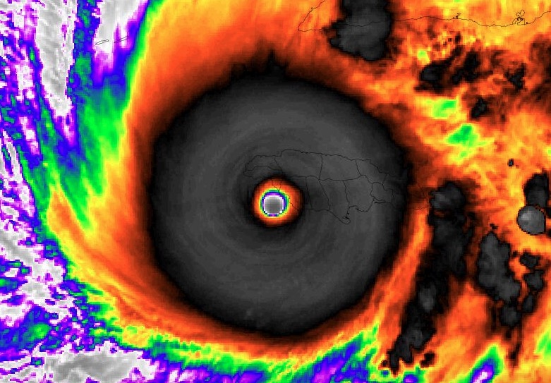
Major Hurricane Melissa - 892mb - 185mph
TheDreamTraveler replied to GaWx's topic in Tropical Headquarters
Wilma is the most intense at 882mb. Unless we're just talking about wind speed then it's pretty much tied with her at 185mph -
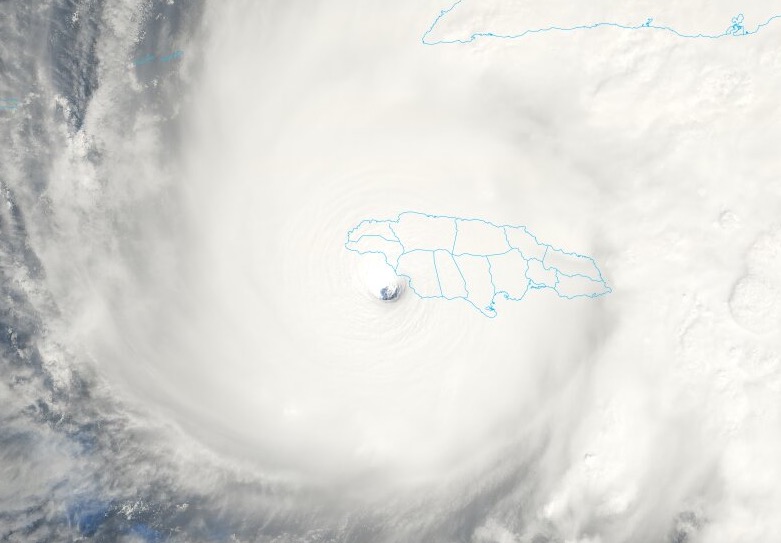
It looks rather like the eye is oscillating within the storm. The bulk of the storm is still making eastward progress.
-
It depends on the codes adhered to, if any. Those resorts, given the investments made, tend to be pretty well built, specifically to handle these types of storms. Now, the flooding is a problem. And this is an unprecedentedly strong hurricane, so we'll see.
-
Melissa hasn't made any eastward progress (per satellite) for the last 90 minutes.
-
Oh definitely. I was just hoping he would be able to get stadium effect shots.
-

Major Hurricane Melissa - 892mb - 185mph
Roger Smith replied to GaWx's topic in Tropical Headquarters
Looks to be in the zone where eastern eyewall might just clear him for moments, or he may stay in the eyewall without a clearance, center of eye track likely to be 10 to 15 miles west; as you know this means he is going to see the strongest winds and the surge there will likely be at its max also, think he may be above that but only just. -

Major Hurricane Melissa - 892mb - 185mph
NorthHillsWx replied to GaWx's topic in Tropical Headquarters
It’s possible but I think it bends back right as it comes onshore. Regardless he is in the absolute worst spot to be wind wise and is taking the full brunt at his location -
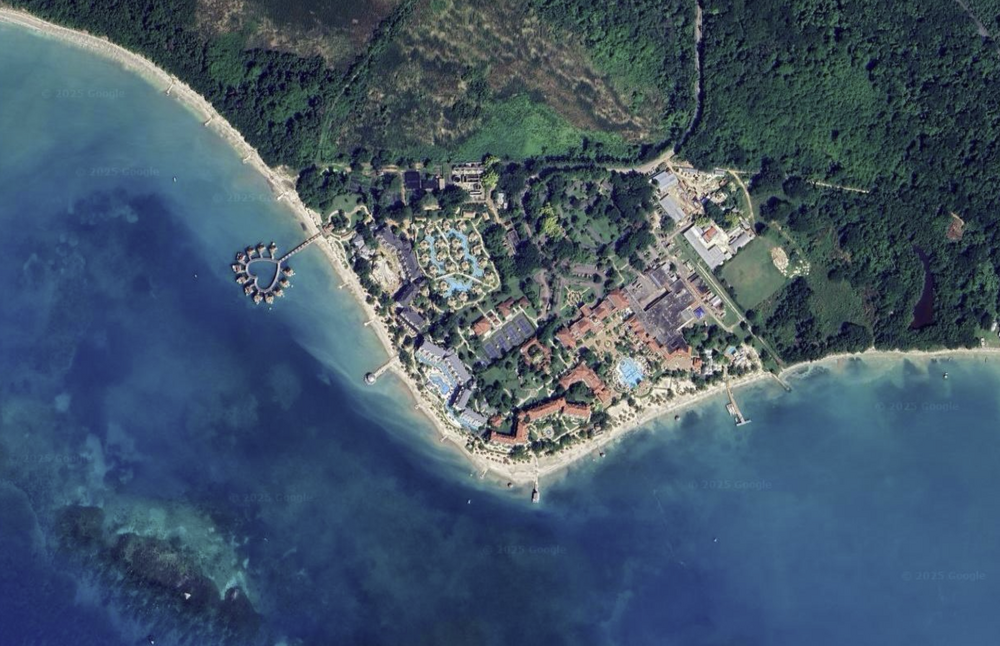
Purely a structural question, but how to these overwater bungalows hold up in a hurricane? Because the ones at the Sandals resort (in pic) just outside Auchindown are going to take a direct hit.
-
He will not be happy about that for sure.
-
Major Hurricane Melissa - 892mb - 185mph
NorthHillsWx replied to GaWx's topic in Tropical Headquarters
Jamaican land is now visible inside the clear eye of a 185 mph sub 900 mb monster -

Major Hurricane Melissa - 892mb - 185mph
hawkeye_wx replied to GaWx's topic in Tropical Headquarters
It had looked like he'd hit the center, but the left hook may leave him just getting into the eastern edge of the eye. -
looks like it has even intensified more then it did already this morning weather channel was saying this is basically a 200 mph hurricane if that is the case then this storm would be the strongest ever recorded in the atlantic basin surpassing even wilma..
-

Major Hurricane Melissa - 892mb - 185mph
gallopinggertie replied to GaWx's topic in Tropical Headquarters
This geology channel made a great (and sobering) video about why Jamaica is so prone to landslides. https://youtu.be/QQ4a_01mGQY?si=lUQZ_YOcv_WZ5gLo -
The center of the eye will actually go west of him
-
Is he still properly lined up for the eye with the NNW wobble?
-
Yo! Moving back in February 2026 to the Boston area, location unknown but probably somewhere inside 128. Hopefully I can make Mass Winters Great Again and bring back the snow.... Hope all is well!
-
Major Hurricane Melissa - 892mb - 185mph
NorthHillsWx replied to GaWx's topic in Tropical Headquarters
He’s still got nearly 70 mb to go -
-

Major Hurricane Melissa - 892mb - 185mph
WxWatcher007 replied to GaWx's topic in Tropical Headquarters
Was just going to post. Glad they made it out ok. -
Edge of eye wall coming onshore now.
-

Spooky Season (October Disco Thread)
DavisStraight replied to Prismshine Productions's topic in New England
Hardly any here either, last year the deck was covered with them, we'd clear them and a few days later the deck was covered again. the neighbors' goats ate well last fall. -
The real horror may be the flooding that comes down from the mountains into places like Kingston.
-
A 53rd Weather Reconnaissance Squadron crew (call sign TEAL 75), known as the Air Force Reserve Hurricane Hunters, is returning to it's forward operating location in Curaçao after encountering heavy turbulence today while entering the eye of Hurricane Melissa, a Category 5 storm. During the event, the aircraft briefly experienced forces stronger than normal due to turbulence. While this does not automatically indicate damage, standard safety procedures require an inspection before returning to operations. The 53rd WRS is an Air Force Reserve unit assigned to the 403rd Wing, Keesler Air Force Base, Miss.
-
Stayed there 2 yrs ago. Nice resort


