All Activity
- Past hour
-
Poor ball spacing
-
We tend to suck a lot nowadays
-

January 2026 regional war/obs/disco thread
40/70 Benchmark replied to Baroclinic Zone's topic in New England
It's always nice foreseeing a January 2011 redux en route when most of SNE is single digits with nothing imminent. -

January 2026 Medium/Long Range Discussion
soadforecasterx replied to snowfan's topic in Mid Atlantic
Not a bad mean if you ask me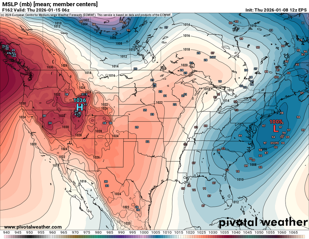
-

January 2026 regional war/obs/disco thread
weatherwiz replied to Baroclinic Zone's topic in New England
Maybe Marco Sturm can transition practices outside and teach the Bruins how to play defense and punish them by making them stand outside in Arctic air at a clip of 30 minutes for each penalty they commit during a game -

January 2026 regional war/obs/disco thread
Ginx snewx replied to Baroclinic Zone's topic in New England
It is always a ball reading the doom and gloom posts during the Jan thaw as we enter the best period of the winter for climo snow. You know who you are. -
it doesn't even go that far
-
Now that was a cool 12z suite.
-
2025-2026 ENSO
40/70 Benchmark replied to 40/70 Benchmark's topic in Weather Forecasting and Discussion
What are you smoking? -
January 2026 regional war/obs/disco thread
Ginx snewx replied to Baroclinic Zone's topic in New England
Zero snow here -
For anyone keeping model-score, the UK is very unsupportive of a Thurs-Fri snowstorm at the end of its run. It looks even worse than the GFS.
-
Euro Ensembles Tony?
-

January 2026 regional war/obs/disco thread
CoastalWx replied to Baroclinic Zone's topic in New England
Toboggans on a 2” glacier in Moosup. -
January 2026 regional war/obs/disco thread
CoastalWx replied to Baroclinic Zone's topic in New England
At the time it was the model suite that was out, but the other guidance showed that too. At least the 12z euro looked better today. It would just be nice to get multiple model runs showing something more favorable instead of a random set of guidance here or there doing it and then going back to ass. Let’s just stabilize something good for once. -
I hear that train way way off in the distance... some good vibes coming in on the 12z.
-

January 2026 regional war/obs/disco thread
tamarack replied to Baroclinic Zone's topic in New England
Jan 94 Gardiner, Maine 26 3 -16 T T 25 27 11 -21 T T 25 28 45 -1 1.61 2.5 24 29 41 18 .01 21 30 18 0 21 31 15 -10 21 -
January 2026 regional war/obs/disco thread
40/70 Benchmark replied to Baroclinic Zone's topic in New England
Great, pond hockey on my driveway after the next cutter. -
Thats the marine layer or coastal front. ERI is very susceptible to sleet and poor snowgrowth. Other than March 18 that is the reason you see drop off
-
January 2026 regional war/obs/disco thread
weatherwiz replied to Baroclinic Zone's topic in New England
@40/70 Benchmark getting back to the end of last weeks discussion regarding that fast flow stuff...I retract what I had stated and I will also add that anything blaming fast flow is also voodoo...to a degree -
100% probably one of the better model suites of the winter thus far. Bottom line: there's potential next week, but no one should be spiking the ball. I fully expect swings with each run, hoping to at least see a trend at 18z where things are still there.
-
I think what a lot of people here forget that you need everything to come together perfectly to get a big snowstorm for the coastal corridor. Cold air in place, storm diving down to the gulf of mexico, picking up moisture, coming up the coast. Or energy from Canada merging with a coastal system to throw snow back in to the big cities (eg Miller A or Miller B systems) It is not easy to get all the pieces in place for a 12"+ system. More likely we are going to get clipper type systems with light amounts, or that might get energized a bit as they approach the coast to give us systems that give us 2" - 8" of snow. Not to mention that all of the models have greater degree of error the further out they try to predict. You get a model showing a huge coastal system on one run, and on the next it is suppressed way to the south.
-

January 2026 regional war/obs/disco thread
moneypitmike replied to Baroclinic Zone's topic in New England
What a beautiful day it’s been today being outside and raking up leaves at the new pit. Lawn cleanup in January. Can’t beat it. -
Yeah, those trying to use flooding pics in Miami as an example of sea level rise and climate change are being completely dishonest and/or patently doomers. And yes, if some in this thread want to label us "deniers", I'm going to label them doomers. Fair is fair.
-
Welcome back Mitch, i have been waiting for you.
-
Yes, and as I pointed out, it wasn't just comparing the magnitude of the extremes on both sides, it was the geographic extent as well. Most of Canada, a huge country, was well below normal last month.


