All Activity
- Past hour
-
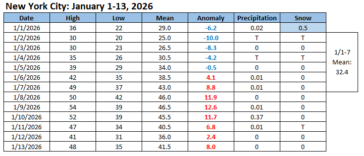
My thinking was as follows: December 27: Below normal temperatures will continue into at least the middle of the first week of January. Some flurries or snow showers are possible late on January 1 into January 2. December 31: The first week of January will likely have a mean temperature below 30° in New York City. The last time that happened was in 2018. The only years since 2000 with a sub-30° mean temperature for the opening week of January were 2001, 2010, 2014 and 2018. January 1: Milder weather could develop on or around January 7th. The milder period appears likely to last for about a week, but there is some uncertainty about its duration. Afterward, conditions could become more favorable for both cold and snowfall, especially if the PNA goes positive. January 6: No significant Arctic blasts or significant snowfalls are likely through at least mid-January. Verification: 1) The first week of January was somewhat warmer than I had anticipated overall. It was still the coldest opening week to January in New York City since 2018. 2) Snowfall totals were light. That's often the case with a predominant PNA- pattern. For December-January, moderate or larger snowstorms typically have a PNA+. 3) Warm anomalies developed a few days earlier than my thinking (January 5th vs. January 7th). Today (January 14th) will likely be the last day with warm anomalies before the onset of a colder pattern. 4) While Arctic air could begin to get involved next week, it appears virtually certain that there will be no moderate or significant snowfalls through January 15th. Going forward, the ensembles continue to evolve toward affirming a predominantly PNA+ pattern. That, in combination with an AO-, has a much higher than climatological frequency of moderate or significant snowfalls. The actual synoptic details will be crucial in determining whether the increased potential will be realized. I suspect that the combination of the AO-/PNA+ and potential re-emergence of an active subtropical jet kicked off by a possible westerly wind burst (WWB) in the Pacific will be conducive to opportunities for snowfall during the second half of January through at least the first 10 days of February. That includes the chance for a moderate or significant snowfall. However, one will need to watch the synoptic details and how things come together. Overall, my confidence for snowfall for this period is notably higher than it was for the first half of January.
-
Worse than last nights run TBH
-

First Legit Storm Potential of the Season Upon Us
WeatherGeek2025 replied to 40/70 Benchmark's topic in New England
is it me or do we need that saturday wave to go way west of us for us to get the bigger storm sunday? -
Euro has nothing for Sunday. So here's where we are: GFS has big storm (won't happen) CMC has a light-moderate event UKMET has a light event ICON has a light-moderate event Either way, almost all models have light snow on Saturday. But the antecedent airmass is very warm so I'd only expect accumulation inland.
-

First Legit Storm Potential of the Season Upon Us
TheBudMan replied to 40/70 Benchmark's topic in New England
Does any of this fall during the Pats game Sunday afternoon or starting overnight ? What time do the Cowboys play Rev ?? #Cancun -
Are these dates off by 1?
-
If the Euro is Dr. NO, the GFS is Dr. Troll for trolling us with hope
-

First Legit Storm Potential of the Season Upon Us
40/70 Benchmark replied to 40/70 Benchmark's topic in New England
Could be, but I feel like this has a better chance for reasons stated. Doesn't have to work out... -
Euro looks like a step in the wrong direction. Tilt looks worse. Energy over the north central is interfering, and not ideal wave spacing. Respectfully, we're all in for disappointment waiting for the lousy GFS to lead and score a coup with one of these. Desperate times.
-
Someone give the Euro some juice.
-
First Legit Storm Potential of the Season Upon Us
40/70 Benchmark replied to 40/70 Benchmark's topic in New England
I never saw the problem before, which is the point that is apparently lost on you. -
The GFS has legs because of this. They’re almost identical at that hour, just a matter of who is right on the strength.
-
Storm potential January 18th-19th
WeatherGeek2025 replied to WeatherGeek2025's topic in New York City Metro
it has a few inches for saturday! -

First Legit Storm Potential of the Season Upon Us
weatherwiz replied to 40/70 Benchmark's topic in New England
That n/s is def more of a kicker on the euro versus gfs. big differences too with that srn stream shortwave and how it evolves across the southeast. Was hoping to see something more positive here -
Euro has a dusting for most on Saturday. 1” for @CAPE
-
And now compared to 6z, either it's slower or it just degraded a bit with the trof...more pos tilt than neutral
-
Yep it’s not going to be a surface depiction we want but the energy is where we’d want it now. Just needs to amp some.
-

January 2026 regional war/obs/disco thread
8611Blizz replied to Baroclinic Zone's topic in New England
-

January 2026 regional war/obs/disco thread
Spanks45 replied to Baroclinic Zone's topic in New England
Euro looks like garbage, good stuff....now if this was reversed, Euro was showing a snowstorm and all the others were OTS, guess which way it would go? Consensus doesn't even matter anymore, the model that shows the lowest chance of snowfall ends up verifying in the end. Can't make this stuff up -

First Legit Storm Potential of the Season Upon Us
Kitz Craver replied to 40/70 Benchmark's topic in New England
Thread Cancel? Lol -

January 2026 regional war/obs/disco thread
TauntonBlizzard2013 replied to Baroclinic Zone's topic in New England
I know that’s coming from a certain poster -
poor wave spacing
-
That energy is a bit weak though
-

First Legit Storm Potential of the Season Upon Us
RUNNAWAYICEBERG replied to 40/70 Benchmark's topic in New England
Yea this may back in to like a low advisory for ema. Nothing more. -

Storm potential January 18th-19th
Jersey_Snowhole replied to WeatherGeek2025's topic in New York City Metro
How are you out that far already?


