All Activity
- Past hour
-

The “I bring the mojo” Jan 30-Feb 1 potential winter storm
Ravens94 replied to lilj4425's topic in Southeastern States
More confluence this run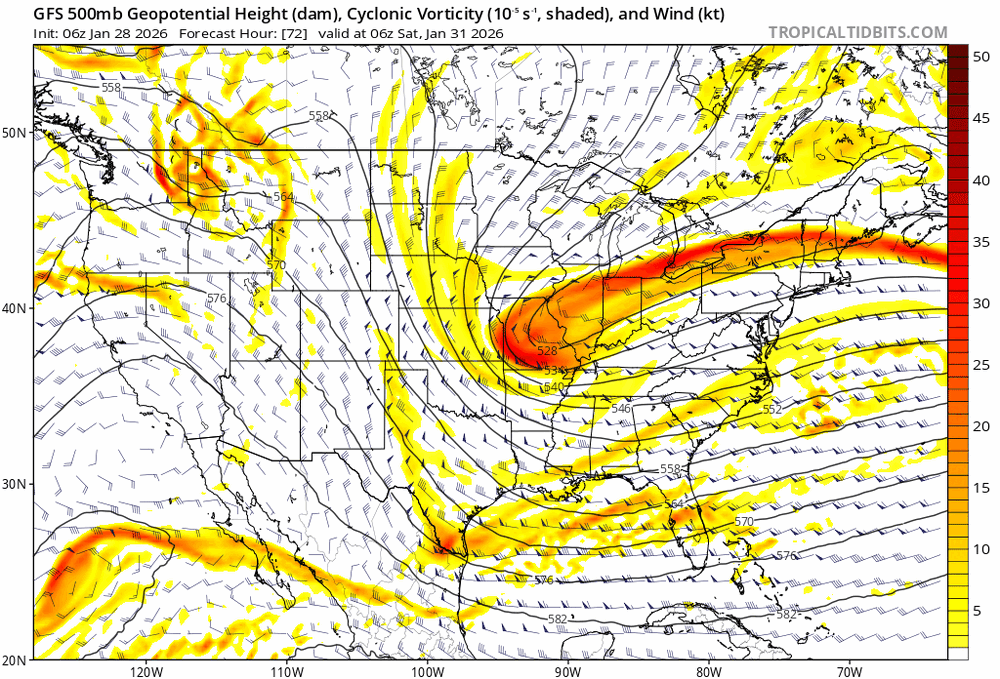
-

Possible coastal storm centered on Feb 1 2026.
RUNNAWAYICEBERG replied to Typhoon Tip's topic in New England
Yes the cape homie. Hallelujahz… -
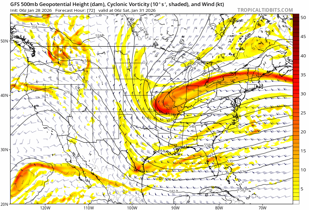
Not much change on the GFS through 06z Saturday.
-

Possible coastal storm centered on Feb 1 2026.
dryslot replied to Typhoon Tip's topic in New England
Unfortunately, Every model has it. -
Kind of sucks that the airports probably won’t capitalize on the snow cover and much below normals temps to hit subzero.
-

Possible coastal storm centered on Feb 1 2026.
weatherwiz replied to Typhoon Tip's topic in New England
That is a ton of convection chasing on the 12z GFS through 72 oh my -

The “I bring the mojo” Jan 30-Feb 1 potential winter storm
Tony Sisk replied to lilj4425's topic in Southeastern States
Thanks!! -

The “I bring the mojo” Jan 30-Feb 1 potential winter storm
BornAgain13 replied to lilj4425's topic in Southeastern States
AI GFS is another Big Hit. Slight tick north -

The “I bring the mojo” Jan 30-Feb 1 potential winter storm
Buddy1987 replied to lilj4425's topic in Southeastern States
Out to 66 trough axis is def more positively tilted and western edge isn't digging as much. Not great thus far. -
probably gonna hit 55 F on sunday
-

The “I bring the mojo” Jan 30-Feb 1 potential winter storm
wncsnow replied to lilj4425's topic in Southeastern States
AIGFS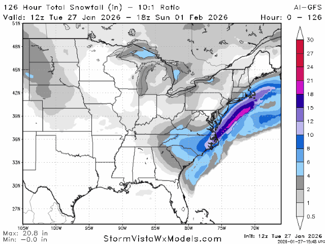
.thumb.png.aad70ced5cb871b35a91567a1f432b4c.png)
-

The Jan 31 Potential: Stormtracker Failure or 'Tracker Trouncing
jgentworth replied to stormtracker's topic in Mid Atlantic
Does the low being closed off over lake michigan on 12z at 60 as opposed to being more oblong and extended in the 06z make a difference or are those just lines and shapes at this point -

The “I bring the mojo” Jan 30-Feb 1 potential winter storm
USCG RS replied to lilj4425's topic in Southeastern States
It's the chance of precip. 70% chance of heavy snow. -

The Jan 31 Potential: Stormtracker Failure or 'Tracker Trouncing
Ji replied to stormtracker's topic in Mid Atlantic
yea def a tick east -
a model with very low skill scores-bottom of the list I believe
-

The Jan 31 Potential: Stormtracker Failure or 'Tracker Trouncing
Terpeast replied to stormtracker's topic in Mid Atlantic
Pacific flow is too fast to back the kicker vort off, so might as well bring it closer and phase to bring that sucker up north. -

The “I bring the mojo” Jan 30-Feb 1 potential winter storm
Snowncanes replied to lilj4425's topic in Southeastern States
AiGFS has the low closing off further north like the RGEM. Dives it down through extreme NE Alabama. Neutral to slightly negative tilt too. Looks like a great run -
The “I bring the mojo” Jan 30-Feb 1 potential winter storm
Tony Sisk replied to lilj4425's topic in Southeastern States
you would think "HEAVY SNOW" would be 100%. Why can't I understand the percentages? -

The Jan 31 Potential: Stormtracker Failure or 'Tracker Trouncing
Cobalt replied to stormtracker's topic in Mid Atlantic
AI GFS looks a tick Northwest? At least at h500 and with that initial slug of precip. -

Possible coastal storm centered on Feb 1 2026.
Kitz Craver replied to Typhoon Tip's topic in New England
What about all the convection east? -

The “I bring the mojo” Jan 30-Feb 1 potential winter storm
DTP replied to lilj4425's topic in Southeastern States
We will have better luck on this storm....you are in a pretty good spot for this type of setup -
9.1° for the low.
-
What in the hell is cfs lmfao.
-
can someone do a PBP ?
-
Sorry, I didn’t realize reality was unacceptable to you. stating and opinion of a storm not happening or missing to our south on a weather forum must go against some code of ethics, I will wishcast like 90 percent of your post are going forward. we’ll disregard the facts that are being displayed across every model. And just keep wishing for nw bumps. That being said if the 12z suites remain the same I will not post anymore regarding this storm as to not clog up the thread.


.png.7d77bafb8ad90c1449cf60c692f9cfbb.png)


