All Activity
- Past hour
-

November 2025 general discussions and probable topic derailings ...
Lava Rock replied to Typhoon Tip's topic in New England
stay safe -
November 2025 general discussions and probable topic derailings ...
Lava Rock replied to Typhoon Tip's topic in New England
I'm hoping and still waiting for a sub 32 morning. -
 What were those seasons relative to normal?
 -
 We bagged 22" dumps in both 22-23 and 23-24. PWM got only 4.2" from the 1st one (Dec 16-17) and 5.3" from #2 (3/24), so maybe not. Just counting on a better 2nd half than last winter, which had but one event over 4" after Christmas. None of the previous 26 winters here had that kind of fail.
 -
November 2025 general discussions and probable topic derailings ...
dendrite replied to Typhoon Tip's topic in New England
Yup. I could see the snow curtains approaching here from the NW before it hit. -
Overnight Wednesday, November 5, 2025 Wind Event
dendrite replied to weatherwiz's topic in New England
Here how the euro trended valid 6z this morning. It sliced and diced mid level winds every run.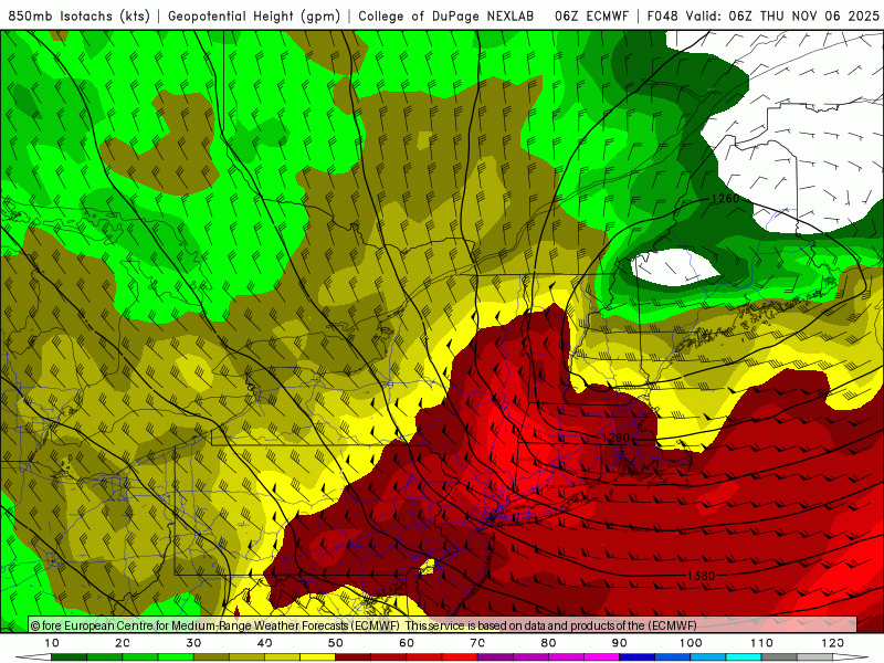
-

November 2025 general discussions and probable topic derailings ...
Typhoon Tip replied to Typhoon Tip's topic in New England
Graupel shower with gusty winds through Ayer an hour or so ago. Bouncing rattling particles with more frozen then liquid at one point. Some of the bigger pieces seemed to carry a bit in the wind, so it gave the affect as though it really wanted to flip. Could see the curtains in the sky moving quickly by. The sun was milked by anvil cirrus as it moved off ... low top convection-like. But the freezing level/mix temp types were not far over head. First frozen of the season in the books! -
But not impossible
-
I like WxBell maps the best and their map interface is easy and works good on mobile. Plus JB is actually entertaining to listen to on his daily videos even if he does see a winter storm behind every blade of grass.
-
Overnight Wednesday, November 5, 2025 Wind Event
Typhoon Tip replied to weatherwiz's topic in New England
that might be why, yeah.. add that to the plausible reasons for model amplitude biases out in time. Over-assimilation in data sparse regions. -
I would agree. @40/70 Benchmark has mentioned a few times that the indicators are not screaming KU’s barreling up the coast and dumping on the I-95 corridor. Especially with a very muted STJ (Niña/-PMM)
-
I feel like you’re due for an old fashioned interior Maine snowy winter.
-
We cant really get above normal with one. That would take a january 2016 type event which happens like once every 20 years.
-
My choices were merely our averages: Watches, did not track Warnings, 5.6 (Median 6.0) Biggest event, 14.8" (Median 13.5") Checked all but CT/RI for pre-Dec 1.
-
What I said is that our new normals since 2018-2019 have been in that lower range around 15”. We are going to need a shift back to benchmark storm tracks at least occasionally for totals getting back above 20” some winters. If we don’t see significant shifts to this pattern over the next 5-10 years, then it will signal that the new average will settle under 20” instead of the mid 20s which has been the very long term average. I came out with 3 potential scenarios a while back. 1) Snowfall continues at these lower levels and only during an occasional season like we had back in 2021 does it get back above average. 2) Snowfall experiences a temporary bounce in the remainder off the 2020s with more benchmark storm tracks than we have had in the last 7 winters. But it could only be a temporary bounce as warming continues. Steeper declines resume during the 2030s. 3) Largest volcanic eruption in hundreds of years cools the planet for 3-7 years with the potential for well above average snowfall. Very low skill forecast since volcanism on this scale is very challenging to forecast ahead of time.
-
Short pump pummeled
-
Not earth shattering. I don’t think anyone here expected a severely negative PDO going into winter. Everyone I’ve seen has been expecting a rise from the severely negative levels. The only unrealistic expectations I’ve seen have been on Twitter….we had some twitterologists back in the spring expecting that we would be in an El Niño/+PDO with a “grand solar minimum” right now….
-
No one can predict the winter right now in November. December looks good right now. We can easily get above normal snowfall with 1 big coastal or 2.
-
 if it clears out, low/mid 60s w/downsloping winds Saturday afternoon?
 -
Yup I really dont see how the math works out to getting even close to our normals (25-30" give or take from philly to nyc) unless we get several big coastal lows tracking along the benchmark. Seems really hard to pull off. Who knows maybe bluewave is right and our new normals are around 15" per season.
-
(002).thumb.png.6e3d9d46bca5fe41aab7a74871dd8af8.png)
Central PA Fall Discussions and Obs
ChescoWx replied to ChescoWx's topic in Upstate New York/Pennsylvania
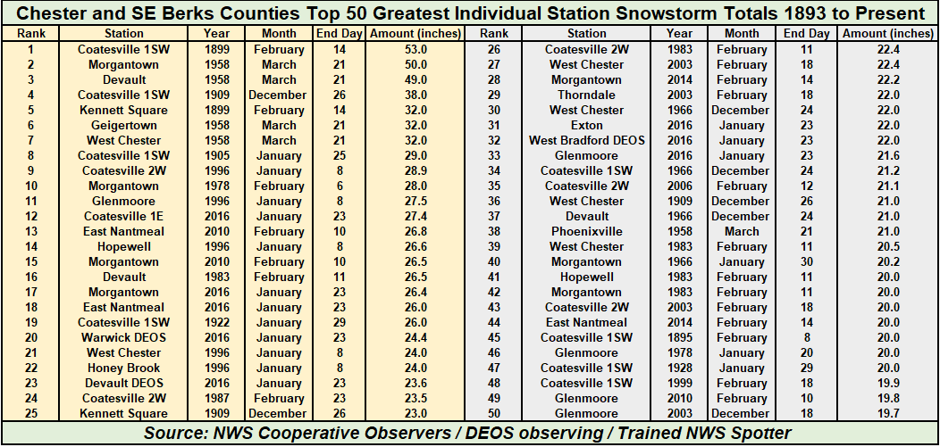
Below are the Top 50 greatest individual snowstorms by station across Chester and SE Berks Counties since 1893. How many of these have you lived through? https://chescowx.com/snow-seasons-storms/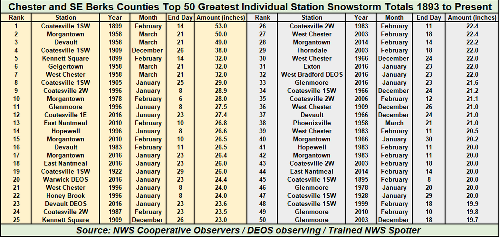
-
E PA/NJ/DE Autumn 2025 Obs/Discussion
ChescoWx replied to PhiEaglesfan712's topic in Philadelphia Region
Below are the Top 50 greatest individual snowstorms by station across Chester and SE Berks Counties since 1893. How many of these have you lived through? https://chescowx.com/snow-seasons-storms/
-
We used to get clippers once in a while but they have largely gone extinct, and 20-30 years ago we used to get hugger tracks that would at least produce on the front end, like the Feb 1995 and March 1993 storms. We really need the offshore benchmark tracks here to have good snow winters now unless these come back.
-
November 2025 general discussions and probable topic derailings ...
dendrite replied to Typhoon Tip's topic in New England
Take that back. Getting a good graupel shower at home now. -

November 2025 general discussions and probable topic derailings ...
Torch Tiger replied to Typhoon Tip's topic in New England
Pelted in Stow. Heavy pellets