All Activity
- Past hour
-

26th-27th event, coming at us like a wounded duck.
Modfan2 replied to Go Kart Mozart's topic in New England
I saw that and the NAM Ginx posted looks good here even into RI; will have to see if that trend continues today. -

26th-27th event, coming at us like a wounded duck.
ineedsnow replied to Go Kart Mozart's topic in New England
FWIW 8z HRRR is even further north and east now compared to 6z -
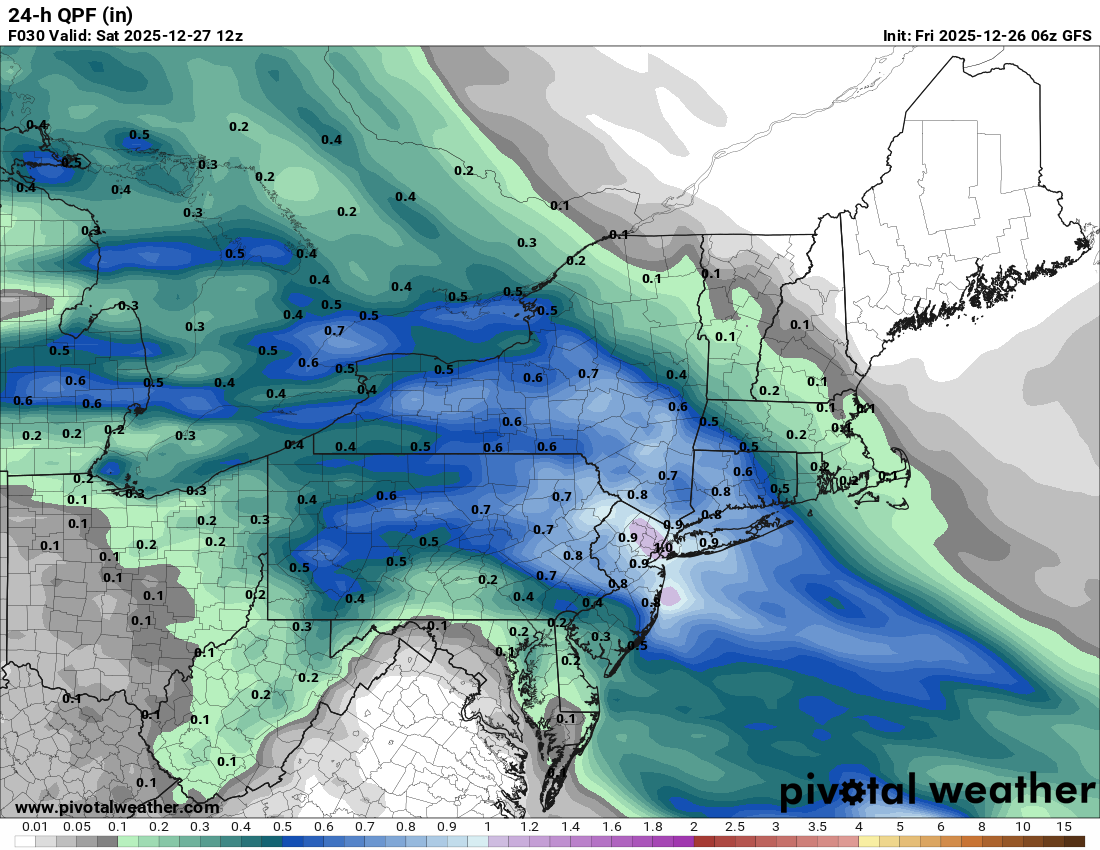
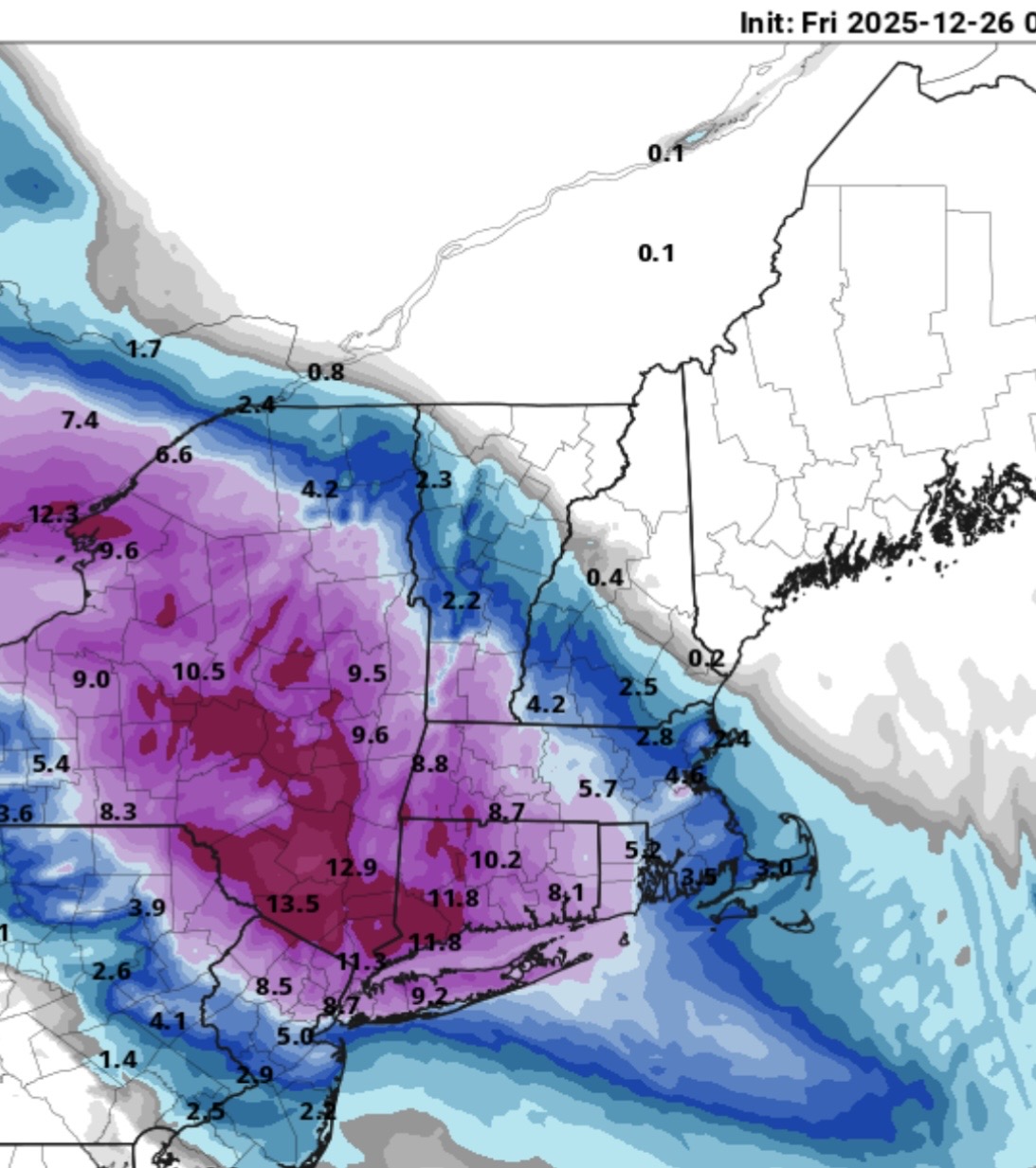
If near warning snow is making it to Boston, a chunk of what my backyard gets even will likely be sleet. I know other models are colder but we’ve seen them verify too cold in these type events. It’s clipper like but behaving like a SWFE with overrunning into cold air. Like that or not, take what you will but historically SWFE is not good for NYC. It’s not your typical SWFE for sure but these overrunning deals so often pull the rug out by trending north at the end. We’re at the point where we just have to see what happens. Hopefully we get good precip that doesn’t shoot over way NE and we’re not waiting for hours in the city as it warms in the mid levels.
-
26th-27th event, coming at us like a wounded duck.
Modfan2 replied to Go Kart Mozart's topic in New England
BOX still not biting east of the river, showing 2-5 most places. -
Just given the cold dense dry air in place I would give a lot more credence to the GFS/RGEM than the northern models.
-
ICON looks slightly better than 0z. GFS and RRFS look very similar to their previous runs. All solid for most of the area! Gotta watch the radar, obs, and HRRR today to see if the northeast shift is real or not.
-

-
it went south a little
-
GFS also held its ground
-
The 6z HRRR and esp NAM should concern snow lovers from NYC south and west. The surface and mid-level low centers continue to tick further northeast. That's getting heavy snow into SVT now, and even BOS on the NAM. That's a yellow caution flag at minimum. On the other hand, the 6z RGEM held steady or even ticked a hair south and wetter locally.
-

26th-27th event, coming at us like a wounded duck.
Ginx snewx replied to Go Kart Mozart's topic in New England
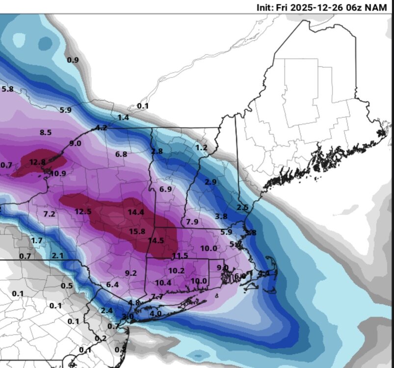
6z NAM IJD
-
Sure would like to see a 25-50 mile slide south
- Today
-
Thats not a warm look as we get into the the end of the first week of Jan
-
6z NAM & Latest HRRR

-
23 in the Bronx. About 12 hours 'til showtime.
-
26th-27th event, coming at us like a wounded duck.
ineedsnow replied to Go Kart Mozart's topic in New England
And 3k.thumb.png.f4ec6598d1912b88b21ff92aa57ca20b.png)
-
26th-27th event, coming at us like a wounded duck.
ineedsnow replied to Go Kart Mozart's topic in New England
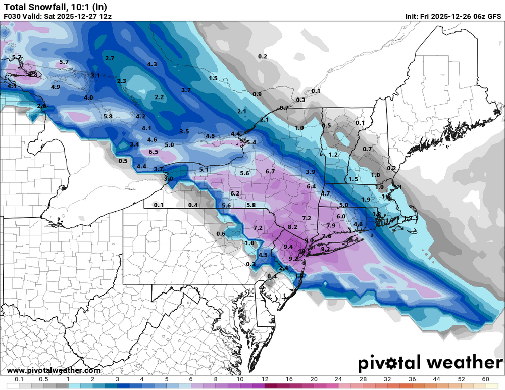
6z HRRR also north.thumb.png.c50cc81e6d67a52425a74dc4d0d28123.png)
-
26th-27th event, coming at us like a wounded duck.
ineedsnow replied to Go Kart Mozart's topic in New England
Man do we pray!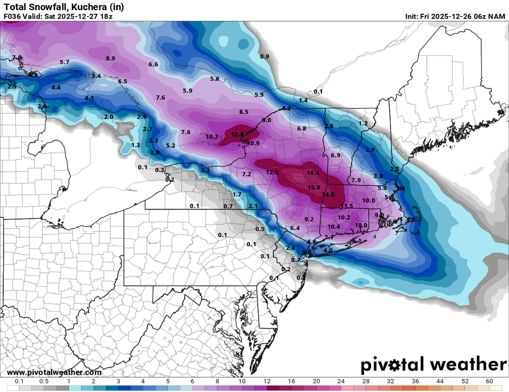
-
26th-27th event, coming at us like a wounded duck.
ineedsnow replied to Go Kart Mozart's topic in New England
6Z NAM zonked again.. warning snows even here -
Dear lord, I’m going to keep quiet.
-
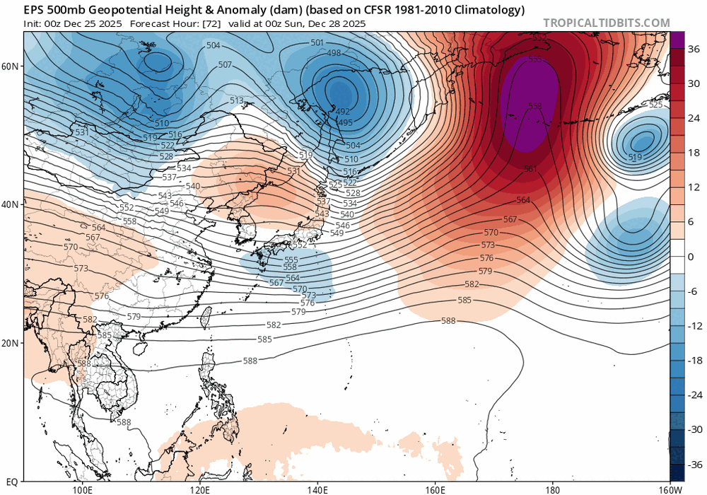
Buyt this should be more or less from the East Asia winter monsoon trough sorta speaking this shifts H from the Bering Sea into Siberia,Mongolia
-
Clear. 15.8F
-

Winter 2025-26 Medium/Long Range Discussion
sbnwx85 replied to michsnowfreak's topic in Lakes/Ohio Valley
Wind and lake effect have some potential to make things interesting locally on Monday. Not huge amounts, but wind-driven snow and cold. Beyond that, the Euro at least has a couple fantasy storms. -

26th-27th event, coming at us like a wounded duck.
The 4 Seasons replied to Go Kart Mozart's topic in New England
Let's go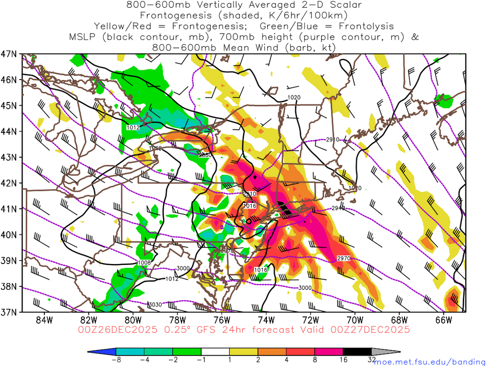
-
26th-27th event, coming at us like a wounded duck.
The 4 Seasons replied to Go Kart Mozart's topic in New England
Yes as Will said 12/14/95 is a farther south version of this. https://www.jdjweatherconsulting.com/dec-14-1995 The first one that came to mind in terms of sfc low track and overall qpf trajectory is 01/14/04. Though contrary to 12/14/95 this is a farther north version of that one. And synoptically at H85 it doesn't appear to be an analog on the list for CIPS. https://www.jdjweatherconsulting.com/jan-14-15-2004


.png.9e063673532af6ff7907a8ac5788ac99.png)
.png.fdc40dbb373a4416242c503148185c55.png)


