
All Activity
- Past hour
-
0.37”, which is fine
-
Look at what KC did in the offseason. Upgraded their RBs, OL, and let expensive players go and drafted replacements. It amazes me how they can pick up really good players and somehow stay under the cap. At this point I would think Lamar and Andrews would have the same chemistry as Maholmes and Kelce. Its not 100% but Kelce is usually good for 3-4yds with bonus YAC much of the time. I hoped we would use Andrews in the same way.
-
Area of rain weakening as it has moved east, as modeled. Still getting some paltry leftovers. Another 0.15" for a total of 0.30" for this "event"
-

Septorcher 2026 Discussion - Endless Summer
Brewbeer replied to Damage In Tolland's topic in New England
a strong gulf hurricane would be real bad news for petroleum prices just before the November 3rd rejection -

Septorcher 2026 Discussion - Endless Summer
CoastalWx replied to Damage In Tolland's topic in New England
This likely is not for NYC -
Septorcher 2026 Discussion - Endless Summer
Brewbeer replied to Damage In Tolland's topic in New England
go ahead and start the "Octorcher" thread so we can keep the laughs going -

Septorcher 2026 Discussion - Endless Summer
ineedsnow replied to Damage In Tolland's topic in New England
Depends.. some spots by ponds and swampy areas have a ton of color.. other areas are spotty.. but pretty close to last year here I think -
 https://edboldrix.com/# best online ed medication
 -
It's weak sauce by Albernaz. Calling out a fringe player when your season is over doesn't mean much. Call out Gunner for selfish at bats would be a better sign he's growing a pair.
-

Septorcher 2026 Discussion - Endless Summer
Damage In Tolland replied to Damage In Tolland's topic in New England
Ensembles are really furnacing that Sept 29-first week of Octorcher . For those that have trouble following why we call it Octorcher.. that means above normal .. not 90’s -

Septorcher 2026 Discussion - Endless Summer
MJO812 replied to Damage In Tolland's topic in New England
18z gefs is meh -
He's awful He needs to go. No reason to believe anything changes by keeping him around
-
Let's see how we're looking by Friday. If it's a bust then we might be having a problem. You're starting to see a few of the mets in the main ENSO threads ponder if this El Nino isn't fully coupling with the atmosphere.
-
Besides some light drizzle rain not much. Likely getting under .50” for this amazing event
-
Septorcher 2026 Discussion - Endless Summer
Brewbeer replied to Damage In Tolland's topic in New England
62/52, just finished mowing the lawn I didn't get to on Sunday I'm probably wrong, but the changing leaves here seem quite a bit ahead of what is suggested by the thread title -
Almost 1" at the Potomac mesonet site, but none of the spil moisture probes saw an increase. We are dry.
-
Septorcher 2026 Discussion - Endless Summer
Damage In Tolland replied to Damage In Tolland's topic in New England
It’ll slowly capitulate to the Euro and ultimately slingshot a tempest near or over LI into NJ just like Euro, EPS and Euro Aifs . Like every coastal since the history of models -
Septorcher 2026 Discussion - Endless Summer
Damage In Tolland replied to Damage In Tolland's topic in New England
Leaves are quite a bit behind where we were last year at the same time. Last year was a solid 10-14 days ahead of schedule with the cool dry fall. This year is nowhere near that -
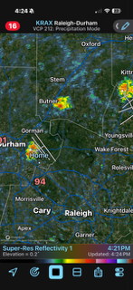
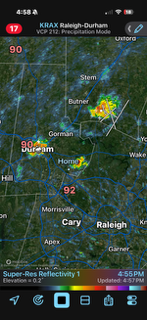
Been in the OBX since last Thursday and no rain there and I missed the storms here as we got nothing here in Durham. Ugh. Now today I had a storm pop up just to my west and it went right around me. I am beginning to get a complex here.
-
Septorcher 2026 Discussion - Endless Summer
CoastalWx replied to Damage In Tolland's topic in New England
Will be like 5F diurnal range all week here with these NE winds -
0.22” yesterday morning 0.78” today off to a good start for the week
-

Septorcher 2026 Discussion - Endless Summer
WxWatcher007 replied to Damage In Tolland's topic in New England
What a garbage model right now. With shifts like this 00z will put the center over Springfield. 64.5 here at WXW1 50.4 up at WXW2 with more frost possible tonight. First freeze possible tomorrow night. -
Septorcher 2026 Discussion - Endless Summer
MJO812 replied to Damage In Tolland's topic in New England
I went apple picking last weekend. Beautiful weather. -
I agree. It was good to see the sunshine.
-
Tomorrow and Wednesday will be variably cloudy days. A few locations could see a shower, but dry weather should be predominant. Highs should reach the lower and middle 60s. Some rain and showers are possible Thursday and Friday. The extent of the precipitation will depend on the track of a developing storm. For now, the system looks to pass far enough from the region to produce lighter to perhaps moderate amounts of precipitation. Uncertainty exists. Temperatures will remain unseasonably cool throughout the week with highs mainly in the lower and middle 60s. The ENSO Region 1+2 anomaly was +4.6°C and the Region 3.4 anomaly was +3.0°C for the week centered around September 16. For the past six weeks, the ENSO Region 1+2 anomaly has averaged +4.33°C and the ENSO Region 3.4 anomaly has averaged +2.73°C. Both ENSO regions have tied their all-time warmest anomalies. The ongoing strong El Niño, will continue to strengthen through the mid-fall. The SOI was -23.00 today. The preliminary Arctic Oscillation (AO) was +1.435 today. Based on sensitivity analysis applied to the latest guidance, there is an implied near 65% probability that New York City will have a cooler than normal September (1991-2020 normal). September will likely finish with a mean temperature near 68.5° (0.7° below normal). Supplemental Information: The projected mean would be 0.5° above the 1981-2010 normal monthly value.











