All Activity
- Today
-

2025 Atlantic Hurricane Season
Stormchaserchuck1 replied to BarryStantonGBP's topic in Tropical Headquarters
I would say the climatological odds favor the African wave staying out to sea. We don't have a huge ridge over the top, but sometimes early in the season you can get a track like Andrew. -
2025-2026 ENSO
Stormchaserchuck1 replied to 40/70 Benchmark's topic in Weather Forecasting and Discussion
We had a strong +PDO wave 2014-2016, it got up there over +2 for a good amount of time. Many thought the phase could be shifting because the std of the +pdo at that time was pretty high, but it tanked a few years after the 15-16 Strong Nino. Looking back, it was just a blip, or an anomaly, in the 30-year trend. -

2025 Atlantic Hurricane Season
Floydbuster replied to BarryStantonGBP's topic in Tropical Headquarters
I remember the long range GFS making a monster hurricane every run. One into Miami. One into New York City. The end result? Hurricane Dean, Cat 5 landfall in Yucatan. Not every long range GFS run is fantasy, especially when it is August and you have consistency run to run showing something developing. The track may be unknown, but something happening becomes more and more likely. -

2025-2026 ENSO
CheeselandSkies replied to 40/70 Benchmark's topic in Weather Forecasting and Discussion
Did we not have an extended period of +PDO in the early-mid 2010s? I recall the slower tornado seasons of those years (mainly 2012-2015, notwithstanding events like Rozel, Moore, Pilger, Rochelle) being attributed to that. -
 I hope Jaxson Dart takes over the job very quickly for you guys. No use wasting any time with Russell Wilson.
 -
My Dad's service was today, and I read a eulogy I prepared. You should all know that I quoted from one of your comments and talked about how important this place was to him. Thank you all.
-
w conspiracy, who planted these sharks?
-
This video I took is from Oak Beach State Park north of Robert Moses. https://streamable.com/qwx7qu
-
They’re even at the marina today. I’ve been there for 40 years, never seen one there or anywhere in the sound even.
-
We haven’t had a hurricane strike but we’ve been pretty active. Irene, Sandy, Fay, Isaias, Henri…not to mention all of the Atlantic Canada strikes including their storm of record (Fiona). It just hasn’t been high end for us, which I do think is unusual given the number of hits.
-
the entire she-bang may evolve (at least early-on) into seaward jobs and ruin SST or-- OHC- jet fuel
-
? I have not seen anything like that . lol Ever
-
Lots of sting rays in the sound and Long Island harbors this heat. I’ve been boating here my whole life and I’ve never seen them before
-
Not this many days with widespread surface air quality impacts. Nothing else comes close to 2023 and 2025 in my memory.
-
40 years since Massachusetts west of the Cape has had a hurricane..Never thought after Gloria (which was largely a disappointment here) it would be 40+ years for the next strike. And I’m not even saying it had to be a Cat 3 at landfall. Ever a weak 2 or strong 1 would have been fine. Is a 40 year drought like that typical around here?
-
Made it up to 78.4 today after not reaching 70 either of the previous two days. My low this morning was 61.7. Very nice for August 4! Currently 66.8 and moderate rain. .
-
Started raining around 6:30 PM. I have accumulated 0.6 inch of rain so far, or 0.15 inch per hour, which is way more than the 0.03 inch per hour shown in the hourly forecast on the point and click from NWS. We have already exceeded the “quarter to half inch” of rainfall we were supposed to get overnight, and the night is still very young. Lots of moisture downstream. The HiRes NAM forecast of close to six inches over the next 60 hours looks much more likely to transpire than the GFS forecast of an inch or so. .
-
18z wasn’t really your friend but it did keep most of the bad wx to the east.
-
For up our way they matter so I don’t disagree there—but I don’t think we’re getting good tropical unless there’s a good pool of higher end deep fuel as a hurricane is rounding the SE coast and slingshotting north. Of course that starts with SST. We’ve had some good years with warmth up and down the EC and I think this is one of the best in the recent active period (2017-) with SSTa and OHC. Better than we saw in 2020 with Isaias and the other recent big heat years in the basin. Combine that with high instability off the coast and a generally favorable environment so far off the EC and anything legitimate in the SW Atlantic and subtropics should cook.
-

2025 Spring/Summer Mountain Thread
gopack42 replied to Maggie Valley Steve's topic in Southeastern States
Hey guys. I'm not on the boards much except for the chatter on snow and hurricanes, so I'll be monitoring things now that the tropics are heating up, but it has definitely been a nice break from the heat the last few days. I was on vacation in Maine last week, and I get home and it's actually cooler than several days I had up there. I was hoping to get under the 50 degree mark on the thermometer the other night. Came close. This is why I moved here permanently! -
 I'd like to hope they can't get any worse
 -
 I hope the Giants will have a better year this upcoming season.
 -

2025 Atlantic Hurricane Season
BarryStantonGBP replied to BarryStantonGBP's topic in Tropical Headquarters
-
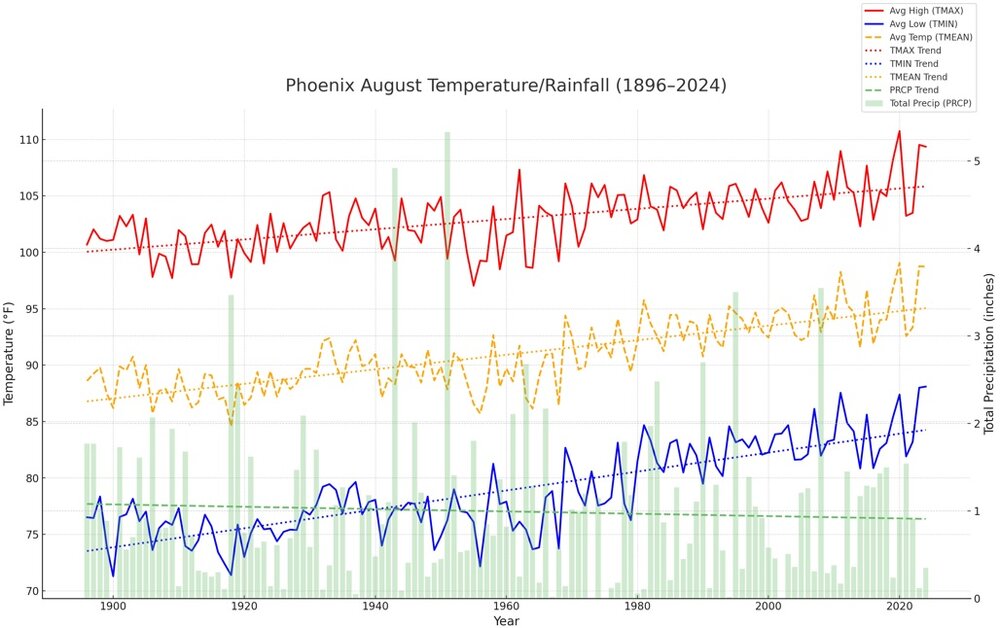
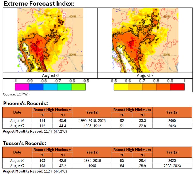
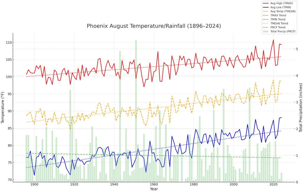
Mountain West Discussion
donsutherland1 replied to mayjawintastawm's topic in Central/Western States
A period of extreme heat will affect Phoenix and Tucson this week, peaking on Wednesday and Thursday. Daily record highs will fall and the August monthly records will be challenged. The long-term August trend for Phoenix is hotter and drier.