All Activity
- Past hour
-

E PA/NJ/DE Autumn 2026 Obs/Discussion
penndotguy replied to PhiEaglesfan712's topic in Philadelphia Region
I’m really curious to see how this ends up, not that it means anything for the upcoming Winter but it could be a sign. -

Strong Nor'Easter/Hybrid Storm Late September 2026
Brian5671 replied to Rjay's topic in New York City Metro
Yeah almost no rain here. LOL. NAM being the NAM and overdoing it. -

October Comes Early: Late September Multi-Hazard Hybrid Storm
Bostonseminole replied to WxWatcher007's topic in New England
so just getting back into this after years of boring foggy weather in CA.. anyone can tell me what is the RRFS model? any good? -
the NE forum is having a meltdown based upon the NAM
-
October Comes Early: Late September Multi-Hazard Hybrid Storm
Bostonseminole replied to WxWatcher007's topic in New England
I think it's still on the table imho -
October Comes Early: Late September Multi-Hazard Hybrid Storm
Brian5671 replied to WxWatcher007's topic in New England
NAM being the NAM and overdoing it. -
 Just saying what they’re mentioning
 -

October Comes Early: Late September Multi-Hazard Hybrid Storm
weatherwiz replied to WxWatcher007's topic in New England
NAM deepens this so much and so quickly that we probably just end up with bands of heavy rain and gusty winds versus a widespread heavy rain shield. Would greatly reduce flooding risk and even wind risk (especially inland). Core of the LLJ never really gets into the region and its quite inverted. But not totally sold on this being as intense as the NAM has it...but this does illustrate such a scenario should that occur -

Strong Nor'Easter/Hybrid Storm Late September 2026
NJwx85 replied to Rjay's topic in New York City Metro
The NAM already starts weakening the storm by Saturday morning. It’s a very different setup than the EURO. It’s also very sparse with rainfall. Could be convective feedback or the fact that the NAM is terrible at handling coastal storms with tropical characteristics. -

October Comes Early: Late September Multi-Hazard Hybrid Storm
CoastalWx replied to WxWatcher007's topic in New England
Nam is kind of a no show. -

2026-2027 Record-breaking El Nino
LakePaste25 replied to Stormchaserchuck1's topic in Weather Forecasting and Discussion
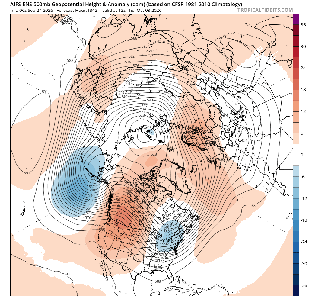
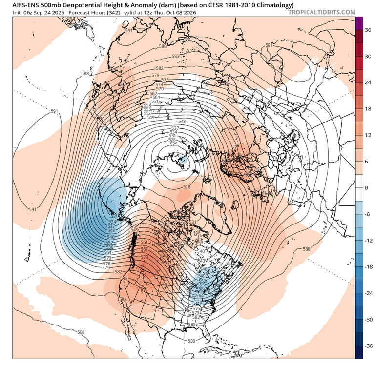
It’s way out there, but the long range AI EPS shows a more east-shifted version of even the 1+2 correlation for October. But, this is also the most East-based El Niño on record, so it would make some sense to see a pattern shifted further east than what we would typically see.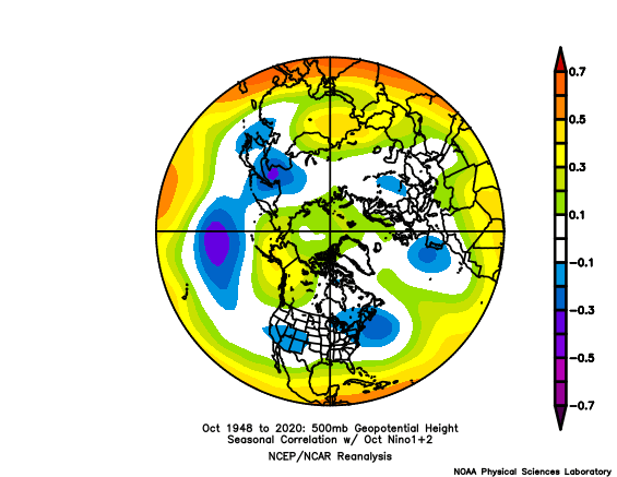
-

October Comes Early: Late September Multi-Hazard Hybrid Storm
WxWatcher007 replied to WxWatcher007's topic in New England
It’s not missing south lol -
Mets are discussing this possibly being a total miss south
-
October Comes Early: Late September Multi-Hazard Hybrid Storm
Bostonseminole replied to WxWatcher007's topic in New England
NAM 3K has it down to 976 at 45hrs, east of the NC/VA border -

2026-2027 Record-breaking El Nino
GaWx replied to Stormchaserchuck1's topic in Weather Forecasting and Discussion
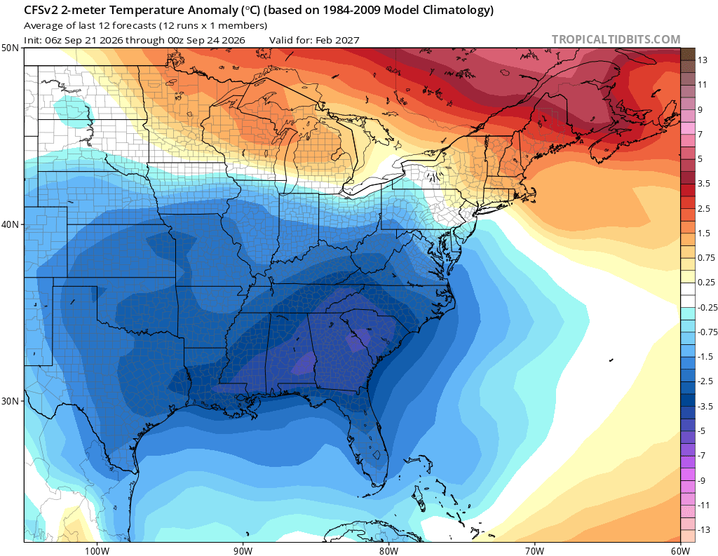
*Fwiw* recent 3 day (12 run) CFSv2 runs for Feb have been cooling back down again. The coldest I’ve seen was the very cold Aug 7-9th mean. The warmest was the recently posted Sep 16-18th mean. The newest (Sep 21-23st) is right in between those: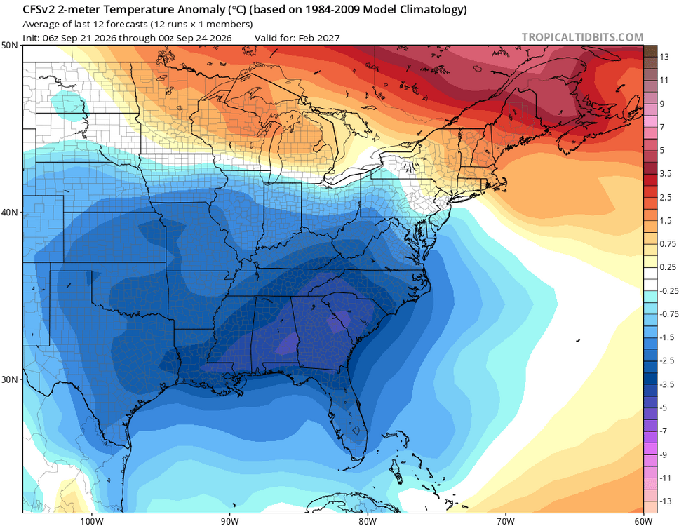
-
Strong Nor'Easter/Hybrid Storm Late September 2026
NJwx85 replied to Rjay's topic in New York City Metro
I hope we get tracks like this in 3 months. -

October Comes Early: Late September Multi-Hazard Hybrid Storm
WinterWolf replied to WxWatcher007's topic in New England
You need the rain…why would you want that? -
October Comes Early: Late September Multi-Hazard Hybrid Storm
Bostonseminole replied to WxWatcher007's topic in New England
the nam might give you that -
Strong Nor'Easter/Hybrid Storm Late September 2026
NJwx85 replied to Rjay's topic in New York City Metro
No. This is a nasty nor’easter. It reminds me of March 2010, if you’re old enough to remember that one. -
October Comes Early: Late September Multi-Hazard Hybrid Storm
CoastalWx replied to WxWatcher007's topic in New England
Let’s bury this in Maryland -
October Comes Early: Late September Multi-Hazard Hybrid Storm
WxWatcher007 replied to WxWatcher007's topic in New England
I think we want that though. It'd be a red flag if the high res weren't picking up on a strong system. I'm really interested in seeing the rain signal. The overnight models painted a nasty zone of sig rain. GFS wanted to paint SW CT as ground zero for flood potential again. -
Thats awesome!!
-
Strong Nor'Easter/Hybrid Storm Late September 2026
GaWx replied to Rjay's topic in New York City Metro
Thanks. Do you see it having a chance to transition from cold core, which we all agree it will start as, to ST status? -
October Comes Early: Late September Multi-Hazard Hybrid Storm
weatherwiz replied to WxWatcher007's topic in New England
If there are trees or limbs hanging over an area where kids play, such as a playscape, and there is signs of tree rot or tree damage you could certainly make a case for negligence on the property owner. No different if you say hurt yourself walking through a parking lot of an establishment because of torn up pavement or concrete -
I can already see the models festering in their schemes to create a snow chance in October ... Probably continues to deepen as these successive fast moving cold knife air mass inserts eventually mean bouts of early Lake Effect cold/LR convection grapple and cat paws. Post the 15th this all gestates into an actual snow chance perhaps. Or not, but the synoptically cryo supportive. **This isn't associated with ENSO