All Activity
- Past hour
-
Exactly Our forecasting system is broken but many cling to it quite vociferously. Some can navigate impressively getting stations installed on public and private lands, they have talent and contacts and expert execution. I wish they would apply that talent to NOAA and NWS and bring about change. I’ve offered suggestions and not just complaints. But I’m a minority voice in that
-

December 2025 Short/Medium Range Forecast Thread
Carvers Gap replied to John1122's topic in Tennessee Valley
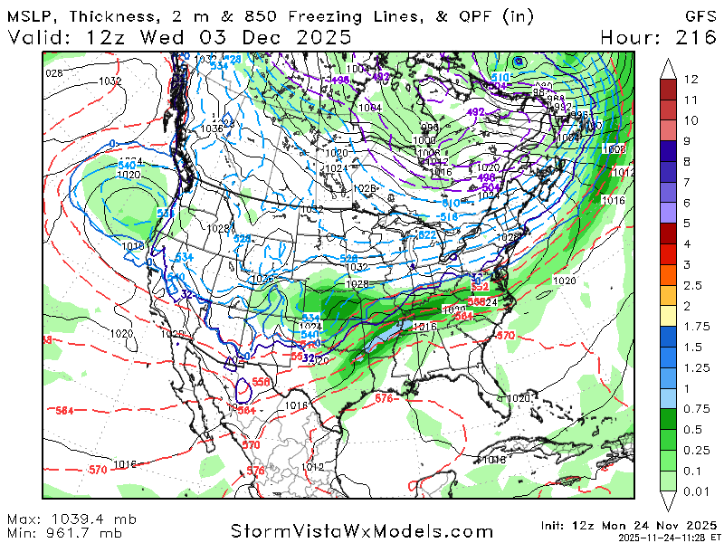
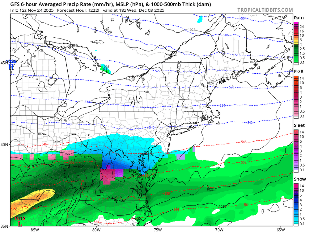
And it is very important to be careful w/ 500 maps with cold air on the prowl. I was watching temp maps that were frigid at the surface, but the 500 map looked benign. The surface map(first image) shows a strong cold outbreak into the Tenn Valley after 300 hours. See that string of high pressures. However, the 500 map looks kind of meh. I think there is a 50/50 chance that we see a strong cold outbreak in/around December 6th. -

November 2025 general discussions and probable topic derailings ...
Lava Rock replied to Typhoon Tip's topic in New England
Watched Train Dreams last night. Decent flick and reminded me of your profession. -

Fall 2025 Medium/Long Range Discussion
A-L-E-K replied to Chicago Storm's topic in Lakes/Ohio Valley
you must be new -
December 2025 Short/Medium Range Forecast Thread
Carvers Gap replied to John1122's topic in Tennessee Valley
The 12z GFS now has a true Arctic outbreak at the end of its run which is exactly what we would expect to see with the MJO flirting with phase 8. And I have said this many times, the GFS deterministic would likely be the first to spot something like that. I don't know if it is right, but it fired the first shots yesterday at 18z. -
December 2025 Short/Medium Range Forecast Thread
Carvers Gap replied to John1122's topic in Tennessee Valley
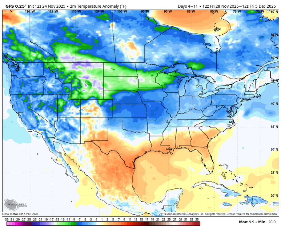
I think the end result of all of this will be some wild swings between cold and warm. The frequency of the troughs and ridges is high. The troughs are deep and the ridges are high. That is a formula for wild swings from model run to model run. I do think troughs tucking under the EPO ridge is probably an error. It is not without precedent, but it usually isn't common this early in the season and especially with an MJO that would want to kick a trough out of the West. The runs which make the most sense are the ones where the troughs get booted if/when they form(from the West). I think the progressive nature of the GFS is probably muting that feedback. -
December 2025 Short/Medium Range Forecast Thread
Carvers Gap replied to John1122's topic in Tennessee Valley
I do believe the GFS is now starting to sense the MJO. That is a MONSTER EPO ridge on that model to begin December. I highly doubt the downstream consequences of that are worked out yet. -
Sheesh man. You’re more negative than me. Let’s at least wait on the Euro.
-
Just like that the warmup is gone during the 1st week of December on the gfs thanks to the negative epo
-

Fall 2025 Medium/Long Range Discussion
TheClimateChanger replied to Chicago Storm's topic in Lakes/Ohio Valley
Record warmth prevailed across Minnesota yesterday, with record highs of 56F at Minneapolis-St. Paul and 55F at St. Cloud. Fargo reached an incredible 60F, setting a daily record and making yesterday the 3rd latest date in the calendar year on which that temperature milestone was reached or exceeded. -

Central PA Fall Discussions and Obs
WmsptWx replied to ChescoWx's topic in Upstate New York/Pennsylvania
Stop talking about smoked Turkey. It's Monday. I stop consuming Tuesday morning to make room. On Wednesday evening I chug a Roaring Springs Premium Water cooler jug to stretch the stomach out. I don't need this temptation already lol -
lol
-
Fall 2025 Medium/Long Range Discussion
A-L-E-K replied to Chicago Storm's topic in Lakes/Ohio Valley
12z guidance looking to close the book on this one before a thread even gets made -
 GFS shows my new Pit1 getting more snow than Pit2 next week. Sell. Sell. Sell.
 -
Pittsburgh PA Fall 2025 Thread
TheClimateChanger replied to TheClimateChanger's topic in Upstate New York/Pennsylvania
If not for that piddly 0.2" on April 9, we'd be near our longest stretch without measurable snow on record right now, as that was the only measurable snow after March 8. -

-
1 run but the gfs showed what a negative epo can do.
-
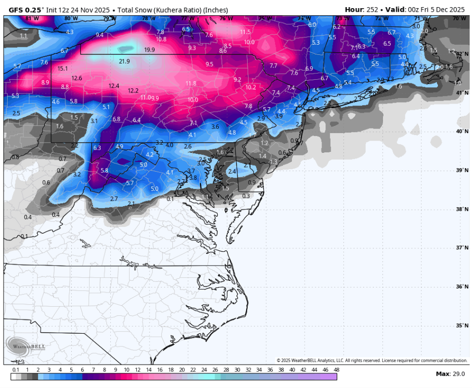
Nice GFS run for mid-next week (weenie)
-
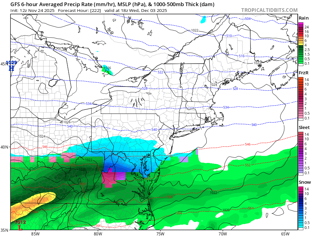
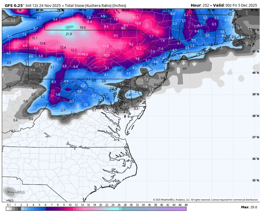
well i'll be damned. DC winter storm on December 3-4.
-
Links to New England Ski Area Web Cams in one easy to get to location. If you have updated links for existing cams, new resorts to add, etc, please post below and I'll update the post. Thanks! VT Killington: https://www.killington.com/the-mountain/webcams/mountain Okemo: https://www.okemo.com/the-mountain/mountain-conditions/mountain-cams.aspx Stowe: https://www.stowe.com/the-mountain/mountain-conditions/mountain-cams.aspx or https://player.timecam.tv/express/index.html?C=D786BEJG4F5A Stratton: https://www.onthesnow.com/vermont/stratton-mountain/webcams Sugarbush: https://www.sugarbush.com/mountain/webcams Jay Peak: https://jaypeakresort.com/resort/photo-day Mad River Glen: https://www.madriverglen.com/live-web-cam/ Bolton Valley: https://www.boltonvalley.com/the-resort/web-cams/ NH Loon: https://www.loonmtn.com/mountain-report#webcam Waterville: https://www.waterville.com/cams Gunstock: https://www.gunstock.com/discover/webcams/ Bretton Woods: https://www.brettonwoods.com/live-cam-forecast/ Attitash: https://www.attitash.com/the-mountain/mountain-conditions/mountain-cams.aspx Sunapee: https://www.mountsunapee.com/the-mountain/mountain-conditions/mountain-cams.aspx Cannon: https://www.cannonmt.com/mountain/webcam-daily-photo Wildcat: https://www.skiwildcat.com/the-mountain/mountain-conditions/mountain-cams.aspx Cranmore: https://cranmore.com/cams ME Sunday River: https://maine-webcams.com/sunday-river-webcam or https://www.youtube.com/watch?v=J98tW5YX4Z8 Sugarloaf: https://www.sugarloaf.com/mountain-report (scroll to bottom of page) Saddleback: https://www.saddlebackmaine.com/mountain-report/webcams/ MA Wachusett: https://www.wachusett.com/the-mountain/media-center/webcams/ CT NY Gore Mountain: https://goremountain.com/the-mountain/summit-webcam/ Catamount: https://catamountski.com/winter/the-mountain/mountain-conditions#webcams
-
WINTER IS TRULY BACK BABY!
-

2025-2026 ENSO
Stormchaserchuck1 replied to 40/70 Benchmark's topic in Weather Forecasting and Discussion
12z GFS brough back the -EPO for early Dec Nice High pressure location.. but this is just one run -
and now the 12Z GooFus has backed that up to 12/3!
-
December 3 FOLKS to rain on the GFS
-
Better PV press on the gfs for next week. Like I said , the models have been way too warm in the long range only to get cooler as time goes on.