All Activity
- Past hour
-

October Comes Early: Late September Multi-Hazard Hybrid Storm
TalcottWx replied to WxWatcher007's topic in New England
I was driving on Hoskins Rd to my house on Tuesday and an acorn hit my windshield so hard I thought I was taking fire. -

October Comes Early: Late September Multi-Hazard Hybrid Storm
Lava Rock replied to WxWatcher007's topic in New England
Gonna get porked on the rain Sent from my SM-S921U using Tapatalk -

October Comes Early: Late September Multi-Hazard Hybrid Storm
UnitedWx replied to WxWatcher007's topic in New England
Acorns are on a mission this fall. We've needed our hard hats on a couple outdoor jobs already -

Strong Nor'Easter/Hybrid Storm Late September 2026
EasternLI replied to Rjay's topic in New York City Metro
Ouch. Tomorrow night is really going to rip some winds through here. This is from the euro. 925mb plus a sounding from the same time. I usually feel like winds are whatever, but this time it looks kind of legit. Nam just spit out something similar too. -

2026-2027 Record-breaking El Nino
GaWx replied to Stormchaserchuck1's topic in Weather Forecasting and Discussion
Thank you! I had a brain malfunction! I’ll edit my original post to point to the error and correction of dates. I apologize for my mistake. The new map for Oct 5-11 has a slightly stronger cold signal than yesterday’s: @mitchnick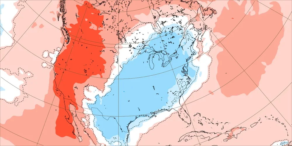
-

Strong Nor'Easter/Hybrid Storm Late September 2026
MJO812 replied to Rjay's topic in New York City Metro
Tunnels to towers 5k walk/ run is still going on Sunday. I will be participating in it. Going to be interesting weather wise. -
 We have a lot of movement below the belt
 -

Strong Nor'Easter/Hybrid Storm Late September 2026
psv88 replied to Rjay's topic in New York City Metro
WHAT...For the High Surf Advisory, large breaking waves of 9 to 15 feet in the surf zone. For the High Rip Current Risk, dangerous rip currents. For the Coastal Flood Advisory, up to one half foot of inundation above ground level expected in vulnerable areas near the waterfront and shoreline. For the Coastal Flood Warning, one to two feet of inundation above ground level expected in vulnerable areas near the waterfront and shoreline. -

October Comes Early: Late September Multi-Hazard Hybrid Storm
CT Rain replied to WxWatcher007's topic in New England
Yeah just odd. LIke did they look at a bufkit sounding? lol This is what happens when you're tied to model blends and WPC grids. -

Strong Nor'Easter/Hybrid Storm Late September 2026
Brian5671 replied to Rjay's topic in New York City Metro
NAM drops 3-5 inches of rain LI now -
Strong Nor'Easter/Hybrid Storm Late September 2026
MJO812 replied to Rjay's topic in New York City Metro
State of Emergency for NYC , Nassau, Westchester and Suffolk. -
October Comes Early: Late September Multi-Hazard Hybrid Storm
Brian5671 replied to WxWatcher007's topic in New England
they've downplayed it the whole way--meanwhile the NAM drops 3-5 inches of rain on LI /S CT flood watch anyone? -

October Comes Early: Late September Multi-Hazard Hybrid Storm
CoastalWx replied to WxWatcher007's topic in New England
Cookies? -
October Comes Early: Late September Multi-Hazard Hybrid Storm
CT Rain replied to WxWatcher007's topic in New England
Really bizarre behavior by them. No coastal flood watches yesterday either around here. Strange. -

October Comes Early: Late September Multi-Hazard Hybrid Storm
Bostonseminole replied to WxWatcher007's topic in New England
3K would make damage boy happy.. 50-60 gusts.. ? -

Strong Nor'Easter/Hybrid Storm Late September 2026
nycsnow replied to Rjay's topic in New York City Metro
Wouldn’t be surprised to see Long Island maybe even queens and Brooklyn get upped to high wind warning. Models seem to be increasing them sat night into Sunday -
October Comes Early: Late September Multi-Hazard Hybrid Storm
CoastalWx replied to WxWatcher007's topic in New England
Convective models finally not treating this as tropical. AWT. -

October Comes Early: Late September Multi-Hazard Hybrid Storm
WxWatcher007 replied to WxWatcher007's topic in New England
I think 60 is possible along the CT coast, with maybe a spot 65 in SE CT. -

2026-2027 Record-breaking El Nino
michsnowfreak replied to Stormchaserchuck1's topic in Weather Forecasting and Discussion
That cold map is for Oct 5-12. -
October Comes Early: Late September Multi-Hazard Hybrid Storm
Bostonseminole replied to WxWatcher007's topic in New England
3K much weaker and thus further north -

October Comes Early: Late September Multi-Hazard Hybrid Storm
weatherwiz replied to WxWatcher007's topic in New England
surprised they didn't with the afternoon update. -

Strong Nor'Easter/Hybrid Storm Late September 2026
jm1220 replied to Rjay's topic in New York City Metro
Satellite already looks like a beast incoming. -
October Comes Early: Late September Multi-Hazard Hybrid Storm
Brian5671 replied to WxWatcher007's topic in New England
they need to convert to a high wind warning there -
October Comes Early: Late September Multi-Hazard Hybrid Storm
weatherwiz replied to WxWatcher007's topic in New England
Maybe gusts 60-65 on parts of Long Island later tomorrow on the 18z NAM. -
October Comes Early: Late September Multi-Hazard Hybrid Storm
WxWatcher007 replied to WxWatcher007's topic in New England
Respectfully submitted