All Activity
- Past hour
-
We are warming up for another disastrous winter in the NW burbs...well I will start posting this nonevent for those west of 95 under obs. after 18Z.
-

2025 Atlantic Hurricane Season
LibertyBell replied to BarryStantonGBP's topic in Tropical Headquarters
There's that big gap I remember between July 9 and August 3 and again between August 20 and September 9. August was crickets lol -
Occasional Thoughts on Climate Change
LibertyBell replied to donsutherland1's topic in Climate Change
At different stages of the planet's evolution did we have a different amount of water on the planet Don? If we are going to pursue space colonization, I don't really see any other way, but to bring water from Earth. There is not enough water anywhere else in our solar system (to my knowledge) to sustain a space colony. If it will help keep sea levels lower than what climate change will do, in a way we're killing two birds with one stone. -

2025-2026 Fall/Winter Mountain Thread
Maggie Valley Steve replied to Buckethead's topic in Southeastern States
Radar has certainly come alive this afternoon. Looks like another day or so of additional showers. I suspect we will see some bright reds added to the leaves as we progress quickly toward peak Fall Leaf Season. -

September 2025 OBS-Discussion centered NYC subforum
anthonymm replied to wdrag's topic in New York City Metro
The last couple days of Sept scares me. GFS has been hinting at a torchfest. -
September 2025 OBS-Discussion centered NYC subforum
LibertyBell replied to wdrag's topic in New York City Metro
This is very weird, did the same hurricane return 20 years later Tony?? 1975: Marilyn struck the Virgin Islands as a Category 3 Hurricane with maximum sustained winds of 115 mph and an estimated minimum central pressure of 952 millibars or 28.11 inches of mercury. The strongest, most damaging part of the storm passed directly over the island of St. Thomas. The island of Culebra reported an unofficial wind gust of 125 mph. Storm surge was generally 6 to 7 feet with an isolated 11.7 storm surge in St. Croix. 80% of the homes and business on St. Thomas were destroyed and 10,000 people were left homeless. 30% of the homes on St. John were destroyed and 60% were left roofless. Marilyn caused 8 deaths and $1.5 billion dollars in damage. (Ref. Wilson Wx. History) 1995: Hurricane Marilyn strikes Virgin Islands. It hit the U.S. Virgin Islands as a strong category 2 storm with top winds of 115 mph. The strongest, most damaging part of the storm passed directly over St. Thomas Island. It caused 8 deaths and $1.5 billion in damages. (Ref. AccWeather Weather History) -
September 2025 OBS-Discussion centered NYC subforum
LibertyBell replied to wdrag's topic in New York City Metro
nice low humidity, 1980s type weather is back -
September 2025 OBS-Discussion centered NYC subforum
LibertyBell replied to wdrag's topic in New York City Metro
why do we call this a coastal low instead of a noreaster? any storm with NE winds should be referred to as a noreaster, I noticed the media is calling it a coastal low too. -
September 2025 OBS-Discussion centered NYC subforum
LibertyBell replied to wdrag's topic in New York City Metro
we should finish below normal here. I don't know how Islip is so warm lol -
September 2025 OBS-Discussion centered NYC subforum
LibertyBell replied to wdrag's topic in New York City Metro
wow it's been very wet in the Poconos! today is my birthday so thanks for the YTD right to my birthday Chris!! -
September 2025 OBS-Discussion centered NYC subforum
LibertyBell replied to wdrag's topic in New York City Metro
It could be the last very warm day of the season, I see my forecast as mid 80s. We have not been warmer than low 80s since the first half of August, it has nothing to do with the ocean as the flow has been NW most of that time and low humidity, good sky conditions. -
Don’t look at the hrrr but how is this in the long range thread
-
AMO state is flipping to negative and it's pretty clear now.
-
all I can say this is MUCH better than the high humidity and flooding rainfalls we were getting year after year. It looks like the cyclic change back to a 1980s type pattern has finally happened.
-
KEd ?
-
It's awesome and 199 is a total bargain Only caveat is that it gets 2nd class citizen treatment from Alterra sometimes, but still great.
-
Coc
-
so glad to return to a 1980s type of pattern
-

2025-2026 Fall/Winter Mountain Thread
ncjoaquin replied to Buckethead's topic in Southeastern States
Picked up a surprise .62 inches(so far) of rain from a shower. Very welcome and much needed. - Today
-
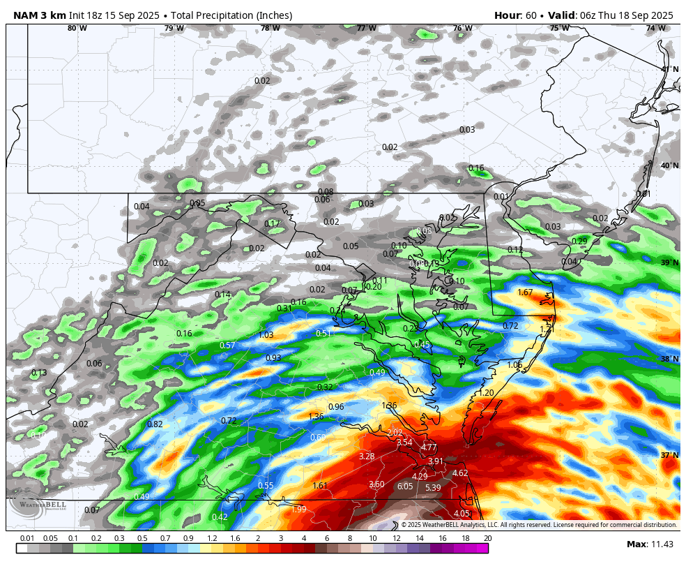
Latest NAM is a disaster if you are looking for rain....WB 18Z 3K NAM

-
12Z UKMET: again has a followup MDR TC to Invest 92L (0Z actually had 2 followups): NEW TROPICAL CYCLONE FORECAST TO DEVELOP AFTER 156 HOURS FORECAST POSITION AT T+156 : 15.9N 37.2W LEAD CENTRAL MAXIMUM WIND VERIFYING TIME TIME POSITION PRESSURE (MB) SPEED (KNOTS) -------------- ---- -------- ------------- ------------- 0000UTC 22.09.2025 156 15.9N 37.2W 1012 31 1200UTC 22.09.2025 168 16.7N 39.4W 1011 32
-
dont look at the 18z HRRR. It took us from Winter Storm Warning to maybe a dusting lol
-
Hugging the euro suite. It’s been a rock while everything else (maybe not GGEM) has been bouncing all over. 18z NAM 3k vs 12z is whiplash.
-
We'll take it:

-
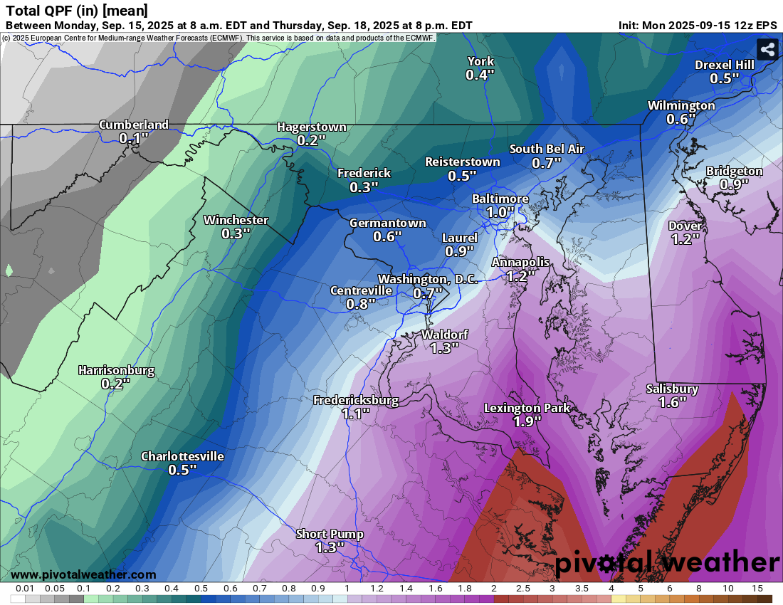
NWS discussion: Clouds will lower and thicken further on Tue with rain or showers slowly spreading further NW through the day Tuesday. Rain/showers should reach the Route 15 corridor by Tue evening. Rain will continue off and on Tue night through Wed as coastal low gets closer to the area. The low pressure center will begin to exit the area Wed night with the rain/showers ending from west to east Wed night. Ensemble guidance suggest half to inch and half of rain may fall along and east of I-95.