All Activity
- Past hour
-

2026-2027 El Nino
jconsor replied to Stormchaserchuck1's topic in Weather Forecasting and Discussion
Nice points. I agree - the lean toward La Ninas has acted as at least a slight brake on the global temp rise over the past three decades. Global temp anomalies past 10 years or so have increased more rapidly in the extratropics than the tropics. See this post from Dr. Joseph Fournier: https://www.linkedin.com/posts/joseph-fournier-7077087_following-the-15-year-great-hiatus-2000-activity-7449541780481654784-8jWQ?utm_source=share&utm_medium=member_desktop&rcm=ACoAAAB0F_QB1PGc4wDzKl0eXPl_N7X02RAnqV4 The attached graph is from the same post and is generated using satellite temperature estimates.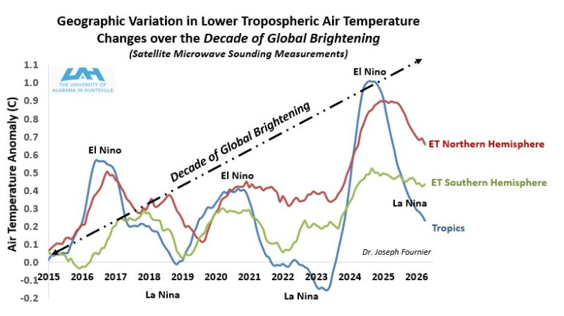
-
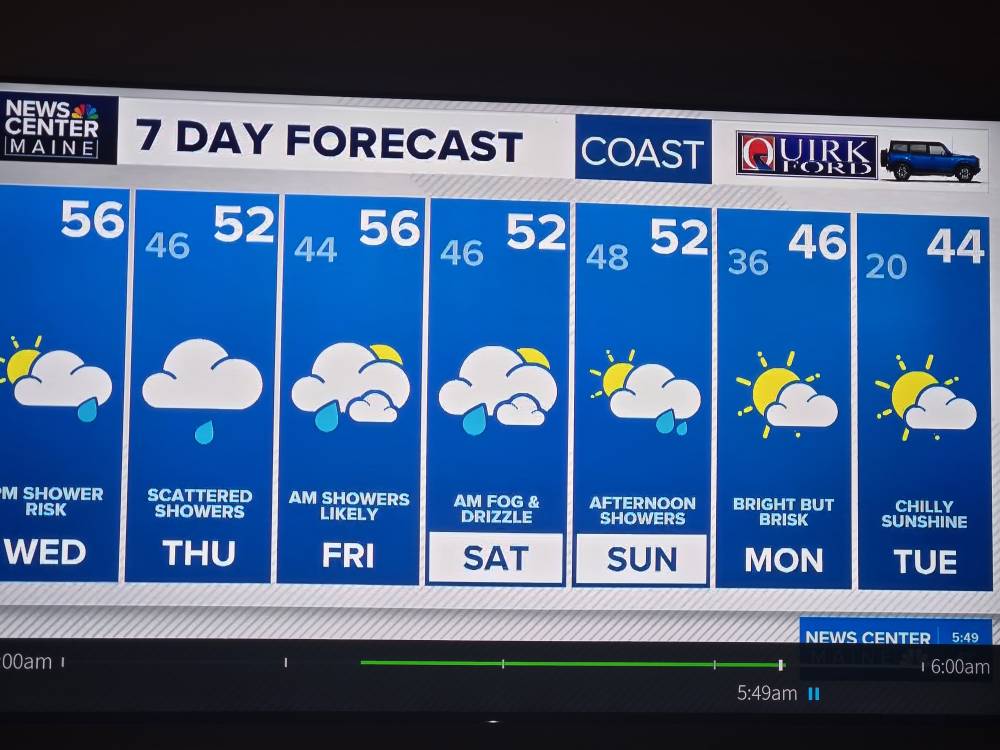
Three more days of HHH . Not looking forward to Sunday and Monday chill
-
One unit permanently on the side of house and others are windows
-
This would be the real wtf.
-
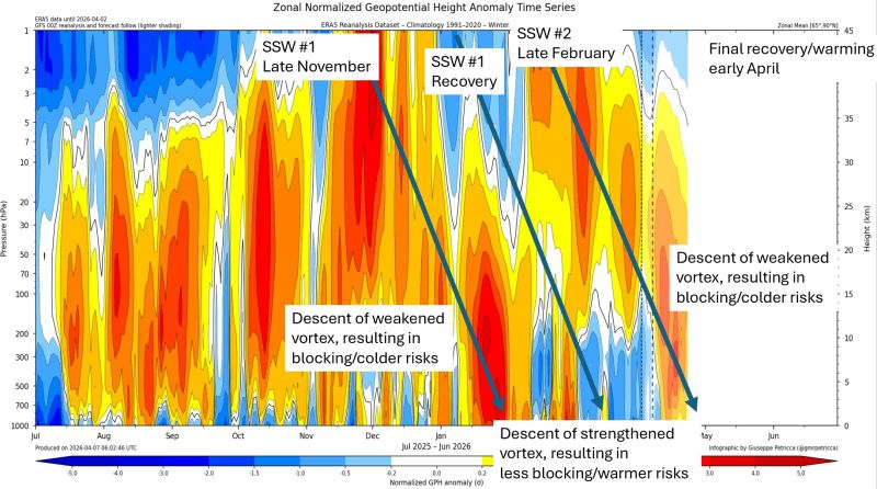
I agree it's ironic. I think that mainly has to do with how slow the downward propagation ("drip down") of above normal heights from the stratosphere to the troposphere was this year. See the attached graphic of polar (65-90N) height anomalies past several months, courtesy of meteorologist Todd Crawford on LinkedIn. Here's his full post: https://www.linkedin.com/posts/todd-crawford-5a02092_the-stratospheric-polar-vortex-spv-had-activity-7447251962808569889--JnW?utm_source=share&utm_medium=member_desktop&rcm=ACoAAAB0F_QB1PGc4wDzKl0eXPl_N7X02RAnqV4 Looks to me like there is a direct link between the recent increase in polar blocking (starting in early Apr near Scandinavia with a separate area near the Arctic Circle) + the forecast near-record strength Greenland blocking last week of Apr, with the notable stratospheric warming event in late Feb and early Mar.

-
Do you have central air, splits, or just install/uninstall window units?
-
Yeah it was pretty toasty. Tough to get the motivation to install when you know a week of wood stove is coming.
-
Bet there was a lot of hot homes last night and 911 sheets stuck to bodies calls. We slept
-
Summer heat
-
But without knowing how warm it was in SNE, I have to admit it felt good up here.
-
April being April
-
Wtf. Sent from my SM-S921U using Tapatalk
-
Both nams have a lot of elevated instability tonight. Overnight bangers.
-

Central PA Spring 2026 Discussion/Obs Thread
pawatch replied to Voyager's topic in Upstate New York/Pennsylvania
Linden launch Williamsport Pa. 60 degrees and pretty good fog this morning. .12” of rain yesterday -
Another pantless morning
- Today
-
Even BIL in Plymouth had a tstm. Hope we get some tonight like hrrr has. Fert is dropped. Now we rain hopefully.
-

Central PA Spring 2026 Discussion/Obs Thread
Voyager replied to Voyager's topic in Upstate New York/Pennsylvania
.37" after I went to bed last night. -
Central PA Spring 2026 Discussion/Obs Thread
Voyager replied to Voyager's topic in Upstate New York/Pennsylvania
Seeing how we swing the pendulum back to almost winter again next week, I'm beginning to think this summer is going to be a roller coaster ride of hot one week, cool/cold the next. -
Still, given how much the map was lit up with warnings, and all the places that were seemingly slammed per radar, I would have expected to see at least a bit more than 5 reports on the SPC page. But I'm sure more (delayed) reports will gradually trickle in throughout the morning.
-
Eh everyone’s asleep. Heck my whole family is snoring right now
-
Not a drop, but watched a good light show to the north. Palatable bust.
-
69 MPH wind gust reported at DTW... Somewhat surprisingly (even for it being nighttime), the MI storm reports are quite sparse for now...
-
Oh boy there’s definitely something on the ground in Taylor. Not great
-
Chased the tornado warning here locally, it tried to produce one, had a very brief funnel cloud just outside of reading but in the time to open my camera app it petered out in between lightning strikes.
-
I was just awaken by another good cell at the front end of the LLJ convection. We got some small hail, wind, and very heavy rain, but nothing severe.