All Activity
- Past hour
-
Shame you are 5 posted.
-

2026-2027 Record-breaking El Nino
MJO812 replied to Stormchaserchuck1's topic in Weather Forecasting and Discussion
I remember people saying we will not get anymore HECS because of the planet warming. Well last year said wait a minute. -
ASOS era
-

2026-2027 Record-breaking El Nino
40/70 Benchmark replied to Stormchaserchuck1's topic in Weather Forecasting and Discussion
Is anyone subscribed to The World Climate Center paywall? I made an inquiry about a trial, but haven't heard back.....I'm looking to access a data set... -

2026-2027 Record-breaking El Nino
mitchnick replied to Stormchaserchuck1's topic in Weather Forecasting and Discussion
Did you scream "police brutality "? -
Dec 5 blizzard
-
2026-2027 Record-breaking El Nino
MJO812 replied to Stormchaserchuck1's topic in Weather Forecasting and Discussion
He blocked me on Twitter -
First time I saw thunder snow. We were on a generator for 4 days. Local DPW left a giant pile of mess at the end of my driveway because someone had never plowed snow before but i digress.
-
 best online canadian pharmacy: CanPointe - canadian pharmacies
-
mexican medicine: FronteraCare Direct - legitimate mexican pharmacy online
-
Since moving here in 2005, far and away most favorite wx event. Only thing that will top it will be a direct strong cane strike up the CTRV or a TOR thru backyard
-

Yellow Medicine County, MN - Climate Fact or Climate Fiction?
donsutherland1 replied to Cobalt's topic in Climate Change
Thank you for your kind words, ChescoWX. I appreciate them. Have a great evening. -
It will turn somewhat cooler with readings in the upper 50s to near 60° for tomorrow and Wednesday before temperatures again warm into the middle and upper 60s for the remainder of the work week. Much of the region could approach or reach 70° on Friday. Unseasonable warmth will continue into the start of November. Dry conditions will likely persist through next week. The ENSO Region 1+2 anomaly was +5.2°C and the Region 3.4 anomaly was +3.4°C for the week centered around October 14. For the past six weeks, the ENSO Region 1+2 anomaly has averaged +5.08°C and the ENSO Region 3.4 anomaly has averaged +3.22°C. ENSO Region 3.4 breaks the all-time record most recently set in the prior week. The ongoing strong El Niño, will continue to strengthen through the mid-fall. The SOI was +9.35 today. The preliminary Arctic Oscillation (AO) was +1.221 today. Based on sensitivity analysis applied to the latest guidance, there is an implied near 97% probability that New York City will have a warmer than normal October (1991-2020 normal). October will likely finish with a mean temperature near 59.5° (1.6° above normal). Supplemental Information: The projected mean would be 2.6° above the 1981-2010 normal monthly value.
-
I’ll say I’ve been fringed in a lot of SNE storms but that’s the only one I’m still jealous of. We got 1.5” lol. What a remarkable event.
-
I really don’t know . That was a hot month , so I would heavily lean no. That morning for the last 2-3 hours of the storm dropped into upper 20’s after 31. 5 paste all night . The last inch or two was powdery
- Today
-
Had you hit 32F or lower in 2011 before the Rocktober snowstorm?
-
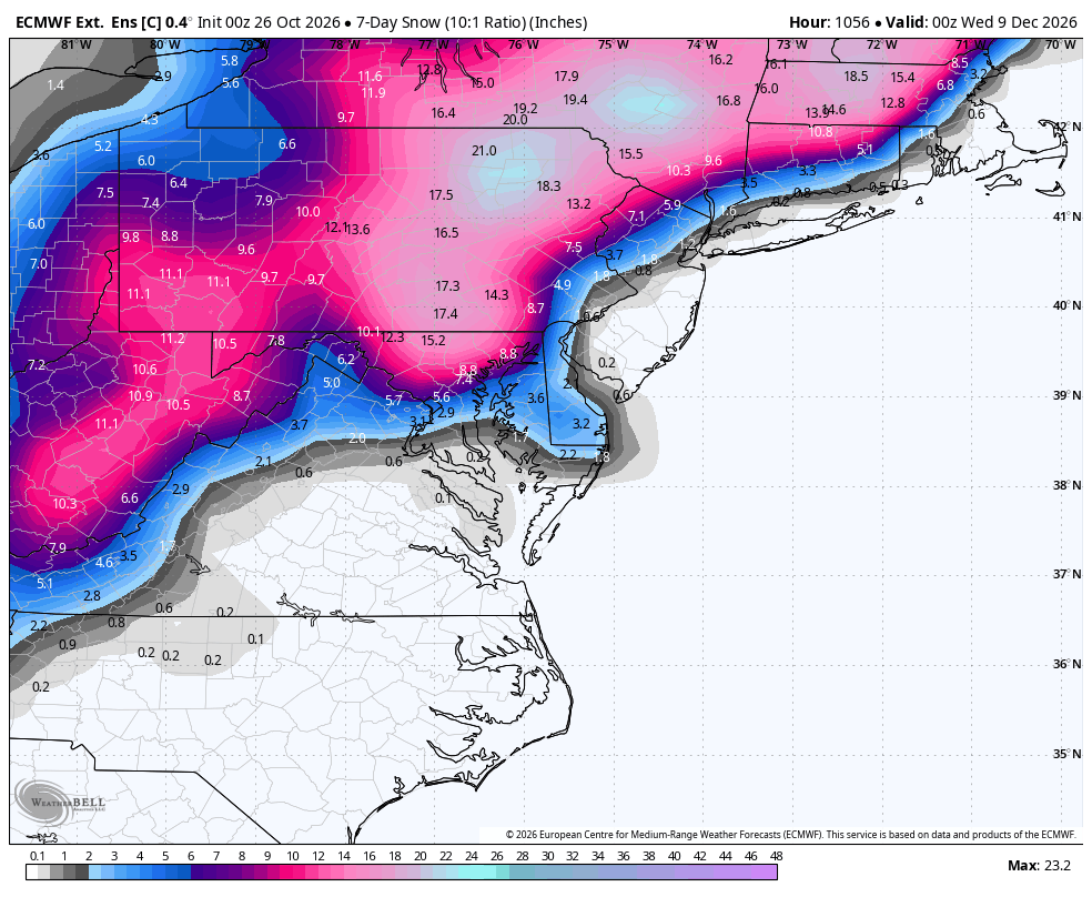
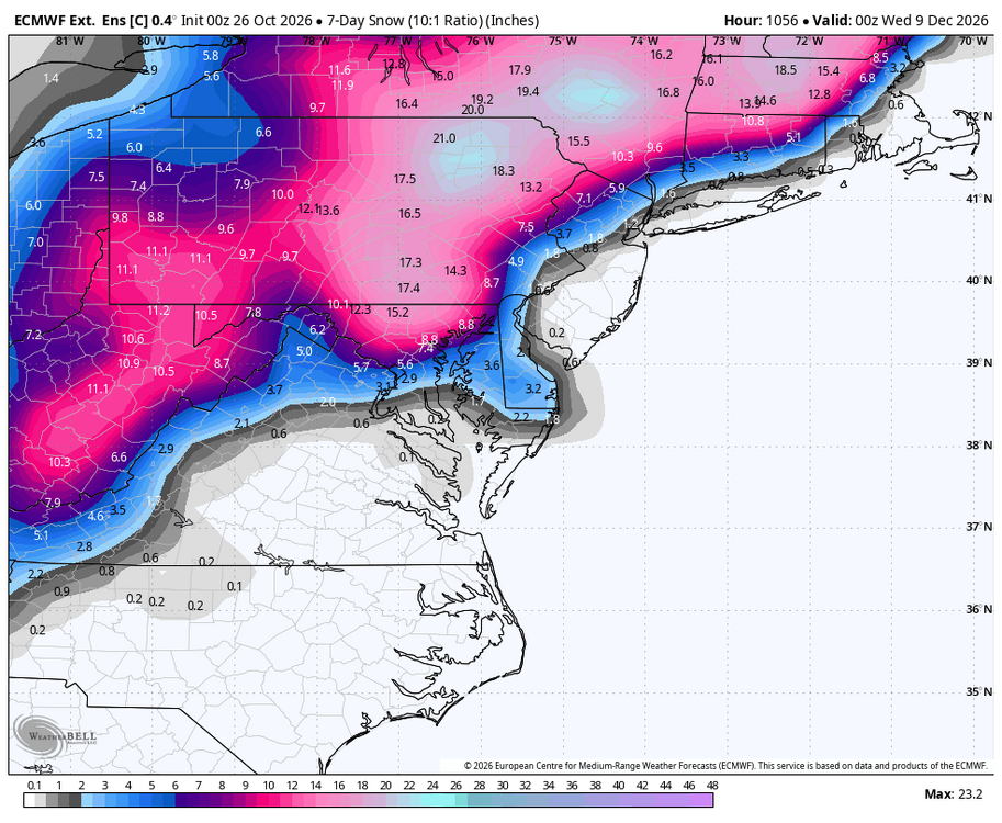
WB latest EPS weeklies control. First week of December is less than 5 weeks away!!!
-
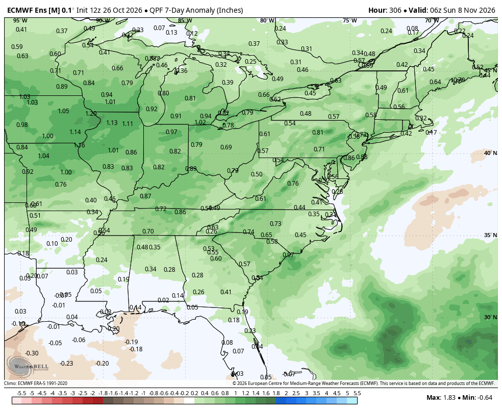
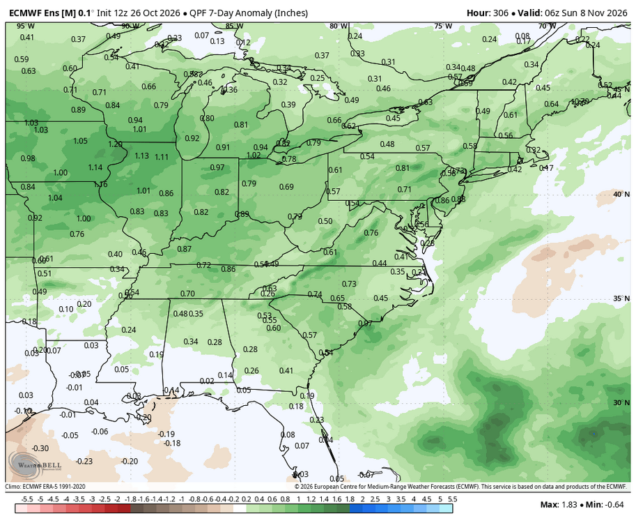
WB 12Z EPS. Next week looks wet.
-
Sizable full moon...noticed it last night from Vegas (been out west the last couple weeks).
-
Good to be back, gentlemen. I'll take your coats. Drinks are in the back.
-
http://zenithindusrx.com/# online drugstore
- Yesterday
-
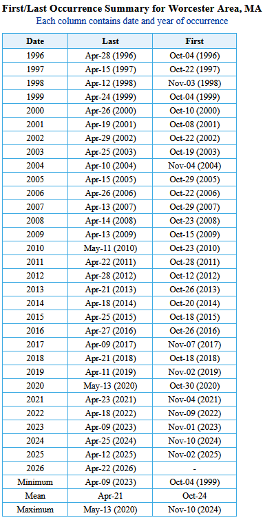
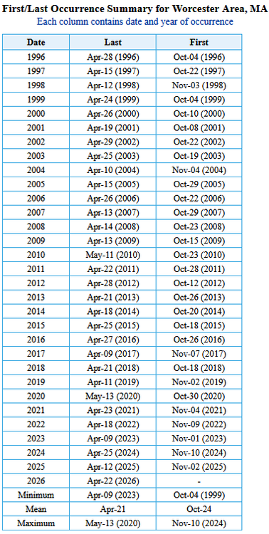
That’s probably longer here . I recall a HFD marathon I ran in mid 2010’s and left here at about 5:00 AM and it was 28 degrees. That’s always run 2nd weekend of Octorcher . Only Oct in last 15 I can remember a freeze that early here
-
2026-2027 Record-breaking El Nino
40/70 Benchmark replied to Stormchaserchuck1's topic in Weather Forecasting and Discussion
And refuse to acknowledge it....(not Adam). -
That’s kind of wild. FROPA through here, some decent NW gusts.
-
ORH hasn’t had a freeze before November since 2020.