All Activity
- Past hour
-
I want to believe. The signal is there. Just afraid to wear my heart on my sleeve again haha
-
What creates the dry slot for metro chatt and southern TN valley? Orographic elements from the plateau? .
-
Thats true but theres still a noticeable hole. I dont think it means anything but its interesting to see how that area keeps getting screwed. Yeah, i just did the same thing, looking back at 12"+ events for SNE. It's actually not as bad as i thought it would be, there's many RI crushers...actually in the past 10-15 years, that area certainly got more crush jobs than anywhere WOR


-
EPS are better than 0z - you could even say much better. The mean shows light precipitation in the Thurs-Fri timeframe whereas 0z was mostly offshore. Several individual members are moderate hits but the majority are still light or misses.
-

Central PA Winter 25/26 Discussion and Obs
Festus replied to MAG5035's topic in Upstate New York/Pennsylvania
One nice thing coming out of a relatively cold pattern is a day like today feels like 75 where 3 months ago it would have felt like 45. -
It does. The trof structure and evolution is very clear at 12z Thurs. That's a squashed, progressively tilted trof. What happens for the next wave for the weekend and beyond is unknown.
-

January 2026 regional war/obs/disco thread
Ginx snewx replied to Baroclinic Zone's topic in New England
Still zero -

Occasional Thoughts on Climate Change
WolfStock1 replied to donsutherland1's topic in Climate Change
Funny the Florida example should come up. U-Haul just came out with their annual migration index the other day: https://www.uhaul.com/About/Migration/ Florida is the #2 growth state, with 8 of the top 10 and 12 of the top 25 growth metros. Lots of people committing suicide, I guess. (in case anyone's wondering - Texas is the #1 state and California is #50) -

January 2026 regional war/obs/disco thread
CoastalWx replied to Baroclinic Zone's topic in New England
Meant after the cutter Ray referenced -
All this year events were shredded by the time the reached RI. I looked thru all your historical snows over 12 inches and there isn't many standing wave issues. Also seasonal shows exactly what influence the big pond has. Western CT has buffer.
-
Had 20" of 9:1 cold sand at single digits from that storm, one of only 4 events (27 winters) to meet blizzard conditions here in the sheltered woods. Unfortunately, I never saw a flake at home - was with family in SNJ, where the forecast 12-16" verified at 1.5", all of which was gone 4 hours from final flakes. 3rd of 4 times that winter that warned storms verified at 1/8 (or less) of the low end of the forecast range. Got to shovel it all, however, getting home about 12 hours after it ended.
-
Poor ball spacing
-
We tend to suck a lot nowadays
-

January 2026 regional war/obs/disco thread
40/70 Benchmark replied to Baroclinic Zone's topic in New England
It's always nice foreseeing a January 2011 redux en route when most of SNE is single digits in mid January with nothing imminent. -

January 2026 Medium/Long Range Discussion
soadforecasterx replied to snowfan's topic in Mid Atlantic
Not a bad mean if you ask me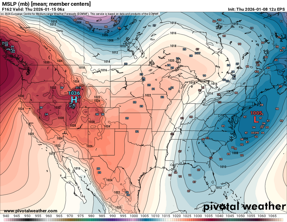
-

January 2026 regional war/obs/disco thread
weatherwiz replied to Baroclinic Zone's topic in New England
Maybe Marco Sturm can transition practices outside and teach the Bruins how to play defense and punish them by making them stand outside in Arctic air at a clip of 30 minutes for each penalty they commit during a game -
January 2026 regional war/obs/disco thread
Ginx snewx replied to Baroclinic Zone's topic in New England
It is always a ball reading the doom and gloom posts during the Jan thaw as we enter the best period of the winter for climo snow. You know who you are. -
it doesn't even go that far
-
Now that was a cool 12z suite.
-
2025-2026 ENSO
40/70 Benchmark replied to 40/70 Benchmark's topic in Weather Forecasting and Discussion
What are you smoking? -
January 2026 regional war/obs/disco thread
Ginx snewx replied to Baroclinic Zone's topic in New England
Zero snow here -
For anyone keeping model-score, the UK is very unsupportive of a Thurs-Fri snowstorm at the end of its run. It looks even worse than the GFS.
-
Euro Ensembles Tony?
-
January 2026 regional war/obs/disco thread
CoastalWx replied to Baroclinic Zone's topic in New England
Toboggans on a 2” glacier in Moosup. -
January 2026 regional war/obs/disco thread
CoastalWx replied to Baroclinic Zone's topic in New England
At the time it was the model suite that was out, but the other guidance showed that too. At least the 12z euro looked better today. It would just be nice to get multiple model runs showing something more favorable instead of a random set of guidance here or there doing it and then going back to ass. Let’s just stabilize something good for once.