All Activity
- Yesterday
-
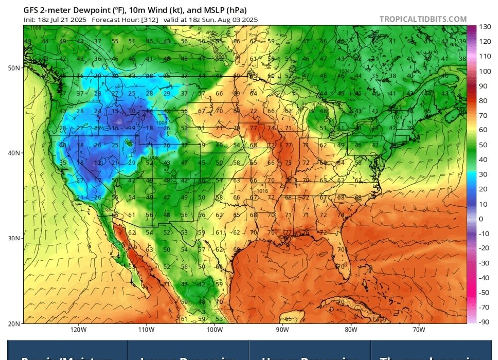
We're gonna put together a pretty impressive streak of daily 70+ dews. May make a run at a 2 week streak. Also will be some 80+ days mixed in as well. Signs we may see some relief around the 31st when we finally get a blast of drier air.
-
Can't complain one bit about this airmass. Dew points actually dropped below 70 for the first time in weeks at my place. The morning's drive home from work will be glorious. Sunroof open kind of nice. Currently 85/65 at the office and 82/71 at mi casa
-

July 2025 Obs/Disco ... possible historic month for heat
Damage In Tolland replied to Typhoon Tip's topic in New England
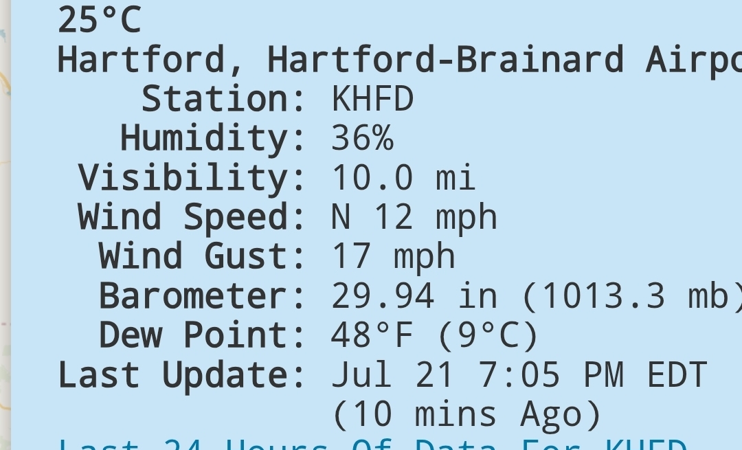
68/52 here now. So that should tell us a low probably in the 55-57 range -

July 2025 Discussion-OBS - seasonable summer variability
Sundog replied to wdrag's topic in New York City Metro
Fantasy land sure but day 10 Euro has highs in the 70s and not because of rain. -

July 2025 Obs/Disco ... possible historic month for heat
kdxken replied to Typhoon Tip's topic in New England
What say ye?
-
July 2025 Obs/Disco ... possible historic month for heat
kdxken replied to Typhoon Tip's topic in New England
-

July 2025 Obs/Disco ... possible historic month for heat
Torch Tiger replied to Typhoon Tip's topic in New England
ensembles aren't warm post 7/30 or so... cooler for sure. not "chilly" lol just few to no 90/70 days or 75/70 type nights -
July 2025 Obs/Disco ... possible historic month for heat
Damage In Tolland replied to Typhoon Tip's topic in New England
There’s literally nothing to make anyone think there’s a chilly shot next week that I see other an op run . That Bermuda high is going nowhere. It’ll be humid right thru day 10 in my opinion -
July 2025 Obs/Disco ... possible historic month for heat
Torch Tiger replied to Typhoon Tip's topic in New England
we'll have a few cool days lol There is certainly no support for anything record-breaking or even impressive, just a relatively cool airmass -

2025-2026 ENSO
michsnowfreak replied to 40/70 Benchmark's topic in Weather Forecasting and Discussion
I was using it as an example. I didnt even look up the departure. Detroits winter was 27.5° which was -0.9° 1991-2020 departures. But again. This turned into more than my intended point. My entire point is that everyone in the U.S. did not "feel" a 34.07° winter avg temp. Some places were warmer and some colder relative to their own averages. -
July 2025 Obs/Disco ... possible historic month for heat
Damage In Tolland replied to Typhoon Tip's topic in New England
With little to no ensemble support it’s not likely . Didn’t think we’d lose you to ACATT -
Cloudy and muggy day down here at the beach north of cape Charles. But clearing off and hoping for lower humidity tomorrow. Gonna spend all day fishing and playing in the water. With beer
-

July 2025 Obs/Disco ... possible historic month for heat
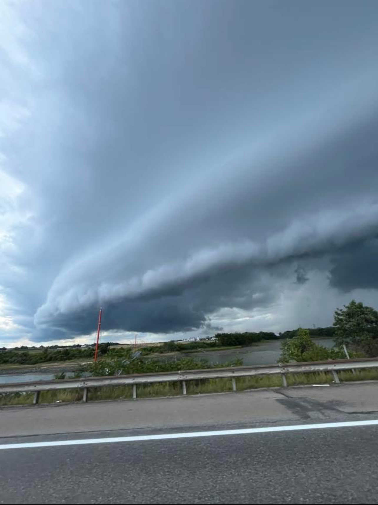
dryslot replied to Typhoon Tip's topic in New England
Another from yesterdays storms
-
An outflow boundary just came through here. No rain here yet. Hearing thunder. Very dark skies just to the south. Edit 7:45PM: Here there was a collision of that aforementioned outflow boundary, which actually appeared to be a seabreeze on closer examination, and one moving in nearly the opposite direction (from inland) that was true outflow from a well inland thunderstorm complex. That collision lead to an area of thunderstorms near the coast and which soon after made it here. There had just been a short period of heavy rain (first since July 13th) though it has for now lightened up. Looking at radar, the thunderstorm area may hang around for awhile. Crossing my fingers this doesn’t turn into a heavy rainfall event. Now moderately heavy rain. There’s been some rather hefty gusts with this, too. High these last two days has been a very uncomfortable 97, hottest so far this year.
-
Mine gets full sun all day and so far is pretty much in line with all the other local PWS's as far as temps are concerned.
-
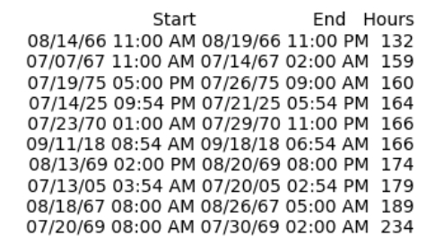
Another 24 hours or so before dewpoints finally drop below 70. Should put the streaks near second place all time
-
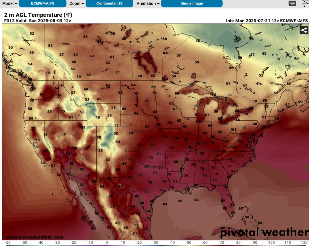
July 2025 Obs/Disco ... possible historic month for heat
kdxken replied to Typhoon Tip's topic in New England
Are they above or below near normal? -
July 2025 Obs/Disco ... possible historic month for heat
Torch Tiger replied to Typhoon Tip's topic in New England
those are near normal temps on 12z on 8/3 -
July 2025 Obs/Disco ... possible historic month for heat
kdxken replied to Typhoon Tip's topic in New England
Finger slipped while highlighting. -
July 2025 Obs/Disco ... possible historic month for heat
Torch Tiger replied to Typhoon Tip's topic in New England
funny guy. Yeah I could see temps some BN temps in there after (most likely) that stronger front arrives mid-next week -
July 2025 Obs/Disco ... possible historic month for heat
kdxken replied to Typhoon Tip's topic in New England

-
July 2025 Obs/Disco ... possible historic month for heat
Torch Tiger replied to Typhoon Tip's topic in New England
why didn't you bold "near" -
After several dry days, a potential active period returns for Friday through Sunday. Latest AFD from Mount Holly- By Friday, with return flow fully in place ahead of an approaching cold front, temperatures and humidity values will continue to increase as thicknesses increase across the area. Heat Index values are forecast to be high enough for potential Heat Headlines. As a cold front approaches, there could be enough instability and disturbances aloft for showers and thunderstorms to develop later in the day and into the evening hours. This front may stall near the area over the weekend, leading to additional showers and thunderstorms Saturday into Sunday. Also, depending on where the front sets up, areas south of the boundary may keep enough heat and humidity in place for additional Heat Headlines on Saturday. With PW values near 2+ inches, heavy rainfall will become a threat with any showers or thunderstorms. There may also be a threat for strong winds as well with some storms.
-
July 2025 Obs/Disco ... possible historic month for heat
Torch Tiger replied to Typhoon Tip's topic in New England
.gif.2824f4fc518c7486f9e3fdf534c4cff5.gif)
-
July 2025 Obs/Disco ... possible historic month for heat
kdxken replied to Typhoon Tip's topic in New England
"Both the West Coast and the Northeast are forecast to be influenced by weak mid-level troughs bringing near normal temperatures to the West Coast and near to below normal temperature chances to the Northeast. "