All Activity
- Past hour
-
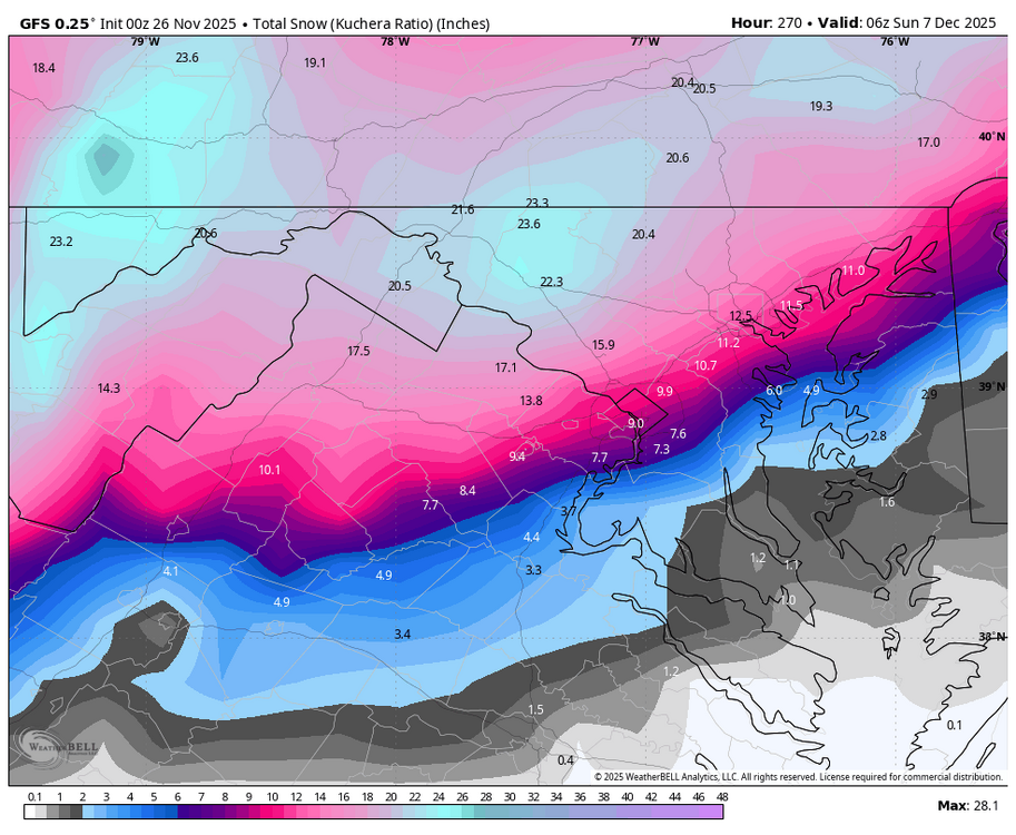
Where is the snow map?
-
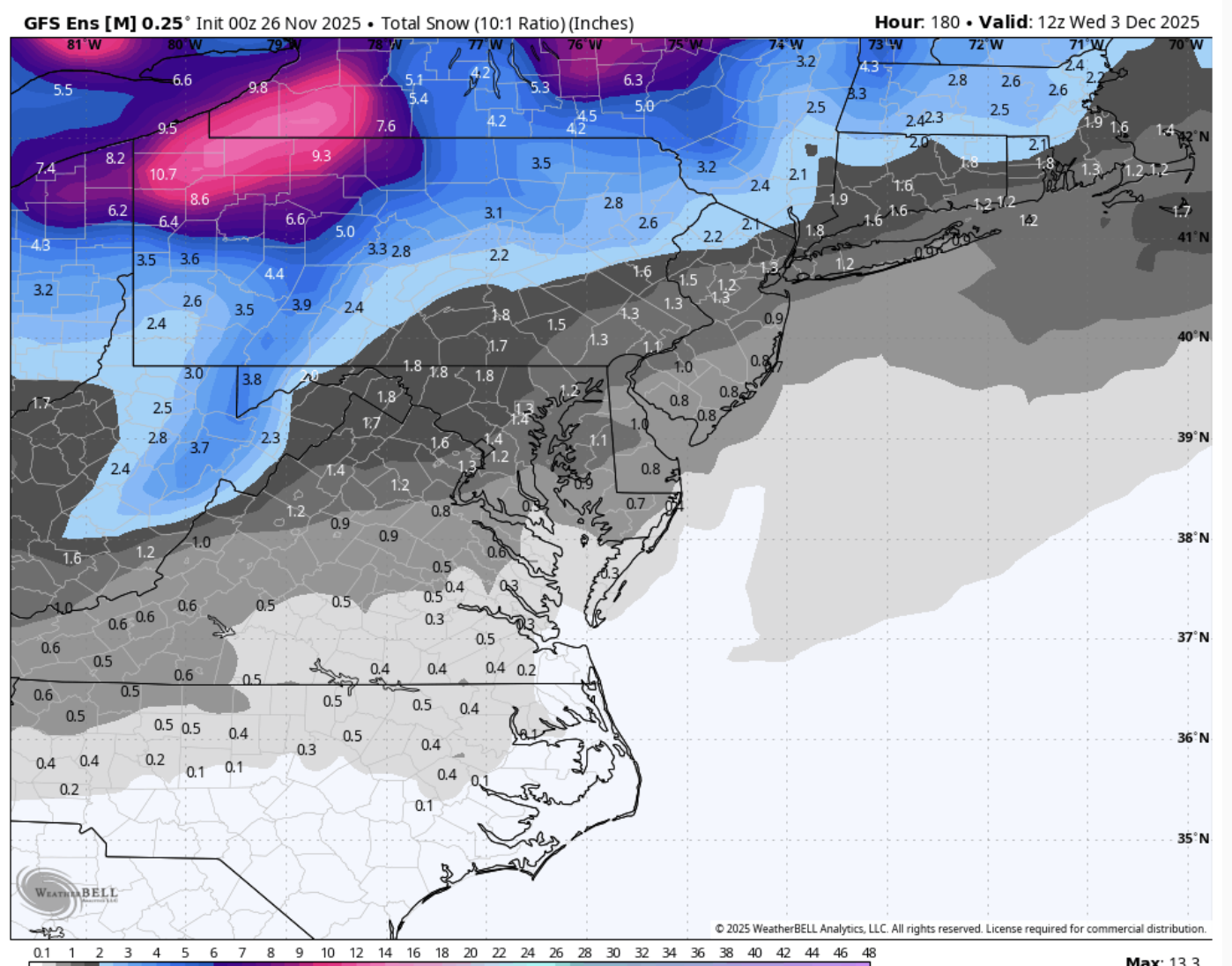
0z GEFS is slightly drier/south compared to 18z. So the GFS and GEFS moved towards each other this run.
-
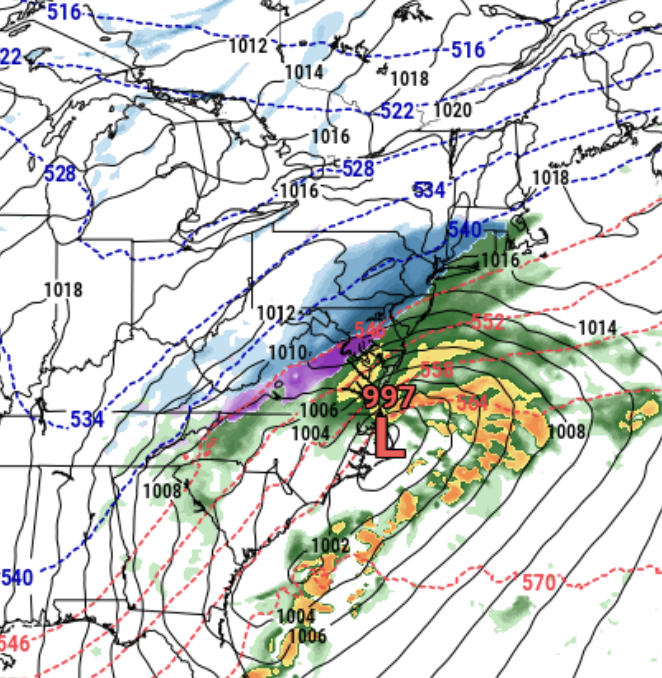
A thing of beauty upstairs too.
.thumb.png.df16e0401eb39ec20d1ab4ffa2906b38.png)
-
GEFS is awful.... ...if you hate snow! There's a substantial increase in the mean from 18z and 12z.

-
So ugly. What a brutal game.
-
Gefs look as good as can be expected at this point imho with the threat.
-
midnight and there's a fuck ton of people online. it's winter already

-
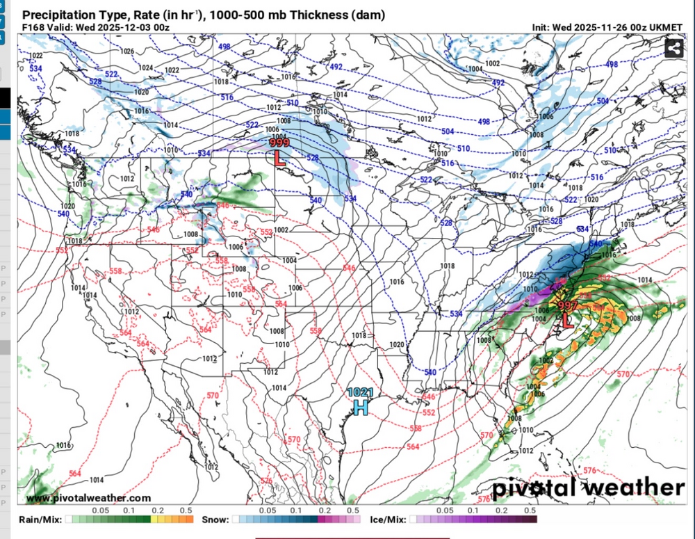
UKMET = very nice
-
UKIE also a substantial hit 5” when the run ends with more to go
-
Ukie is also on board with the storm along the front.
-
Damn I thought we were canceling December and winter as a whole 3 days ago
-
The GFS retrogrades the CA ULL west into the Pacific. If that doesn't happen, the longwave flow across the US would be significantly altered. Our downstream weather is extremely sensitive to the modeled evolution of the western trof over this period. Could still end up balls cold or periodically torched days 6-15.
-
We have been talking early start to winter since October! Would be wild if it actually verified
-
Nice ridge out west and plenty of cold. What a turnaround from the models.
-

Nov 28-30th Post Turkey Day Wintry Potential
Geoboy645 replied to Chicago Storm's topic in Lakes/Ohio Valley
Definitely looks like the potential for a significant hit for the Madison metro is steadily increasing over the last day or so. Could get very interesting here, especially because we are potentially less than three days out from the snow starting to fall on Thanksgiving weekend, with all that entails for travel. Could see headlines and messaging start in earnest tomorrow because of this factor. -
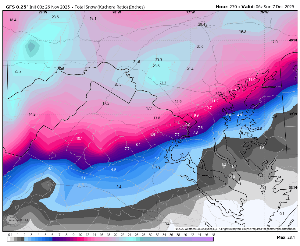
The 0z GFS is an absolutely filthy glutton for snow. I'm going to pretend I didn't see the extended run and keep my personal focus on the mid-range.
-

2025-2026 ENSO
so_whats_happening replied to 40/70 Benchmark's topic in Weather Forecasting and Discussion
It is based on RMM phases not specific to La Nina or El Nino. Phase 8/1 doesn't become as conducive until we head into January and February for the east. I wouldn't expect blazing temps but I certainly wouldn't expect downright frigid outside of the colder period until about mid December/3rd week. Still feel pretty confident in the warming potential as we move into christmas week and the new year. Surely things can change and it will be interesting to see if it does but overall I would expect near normal through much of the east with above normal across the SE. The true test will be what happens with the December 2nd/3rd system and how that sets up. We will be able to see if the models are overzealous in either direction with respect to the SER or cold pressing into SE Canada. -
Legendary early season GFS run.
-
The UK is also an excellent run at 0z (both surface and aloft). Supports the GFS - maybe slightly better even.
-
noticeably warmer out in the last hour.
-
It’s too warm for close burbs but Kuchie is gonna spit out 25” for someone over a 12 day period in early early December. Fun but unrealistic night haha
-
I'm too old to get this excited!
-
Omg. Snowing again on the 6th too. Gonna bat 3/3
-
Dr. No sucked last year with way too many false Yeses, so screw it.
-

December 2025 Short/Medium Range Forecast Thread
jaxjagman replied to John1122's topic in Tennessee Valley
SOI has been fairly chaotic as of late,ups and downs,the last couple weeks,big drop two days ago,ensembles were looking severe last weekend into the first part of Dec,not no more 25 Nov 2025 1009.58 1005.50 7.63 16.34 9.25 24 Nov 2025 1007.56 1004.90 -1.40 17.10 9.38 23 Nov 2025 1009.73 1000.85 38.17 17.97 9.60 22 Nov 2025 1011.59 1003.75 31.56 17.51 9.41 21 Nov 2025 1011.94 1004.90 26.47 17.04 9.28 20 Nov 2025 1013.02 1005.20 31.43 16.68 9.16 19 Nov 2025 1013.90 1005.00 38.30 16.14 8.87 18 Nov 2025 1013.91 1006.65 27.87 15.23 8.46 17 Nov 2025 1013.24 1007.30 19.47 14.55 8.06 16 Nov 2025 1013.02 1008.85 8.20 14.05 7.64 15 Nov 2025 1011.89 1008.00 6.42 13.81 7.50 14 Nov 2025 1011.80 1008.10 5.21 13.71 7.48 13 Nov 2025 1011.52 1009.15 -3.25 13.44 7.37 12 Nov 2025 1012.06 1010.30 -7.13 13.43 7.36 11 Nov 2025 1012.19 1009.60 -1.85 13.91 7.44 10 Nov 2025 1012.05 1008.55 3.94 14.24 7.51 9 Nov 2025 1013.18 1009.05 7.95 14.46 7.52 8 Nov 2025 1015.00 1009.15 18.89 14.82 7.31 7 Nov 2025 1015.88 1008.40 29.26 14.92 6.94 6 Nov 2025 1015.28 1008.05 27.67 14.37 6.61


.png.537bfa01d700740982859b67527a24cd.png)