All Activity
- Past hour
-

2025-2026 ENSO
michsnowfreak replied to 40/70 Benchmark's topic in Weather Forecasting and Discussion
The warmth yesterday and today was very impressive here (70s) as will be the cold early next week. Beyond that, I expect pretty mundane spring weather here in the Lakes for a while. Not warm and not cold. -
High of 85, low of 54. Still no AC. House cools off really nice at night with the ceiling fans on. One more warm day to go.
-
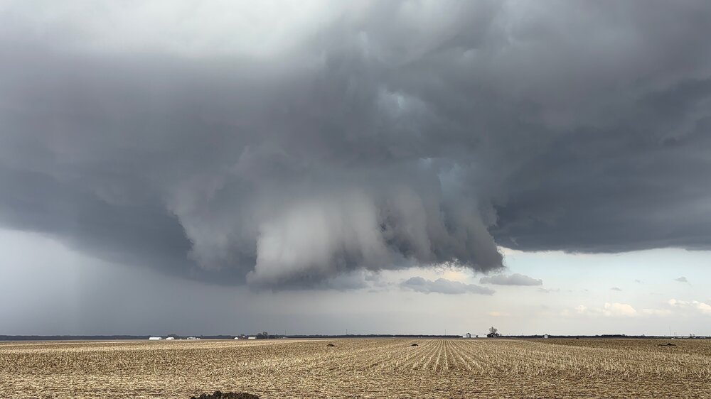
Looks mean from 75 mi south. Good luck out there.
-
-
My son was pissed about a local disc golf course still being snow covered after all this.
-
Still 12-14” here
-
TOG
-
Potential CC drop.
-
Tornado OTG.
-
T warned now
-
and Twarned
-
Big Motion. This wants to plant one.
-
Near Pontiac currently.
-
Pic from my son on the Pontiac cell.
-
Real close to dropping a big dog
-
It’s turning slightly right as well. Its moving right of the warning cone.
-
Dam…that’s something. That thing is bulletproof.
-
Can see the Pontiac sup off in the east/southeastern horizon. Looks pretty badass even from here.
-
Streamer has a broadly rotating lowering just north of Pontiac
-
I don’t know what science book or meteorological book you’re looking at, this is a scientific forum and March Absolutely is a winter month. this has to be one of the most ill-informed posts I’ve ever read on here
-
It’s getting that look now. Grown in size too.
-
That has a strong meso on it aloft, but it seems to be elevated. Definitely a hail mode cell though.
-
Sometimes(probably often) winter ends abruptly here. This may be what we are facing. If so, it was a good run. My heating bill concurs. On to El Nino! Lets hope it is Modoki with NA blocking.
-
9-13" on the level...17" drift...dont ask me how, but I lost 2" Hi of 76.6* recorded on the station located right where I measured. DP is 44.1 Most resilient pack I can ever recall.
-
Storm near Pontiac is trying. Needs a little boundary or something to give it a nudge