All Activity
- Past hour
-
Yeah, could just be a matter of time before the stronger winds mix down to the surface.
-
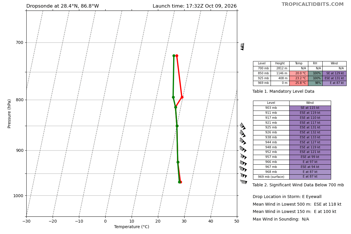
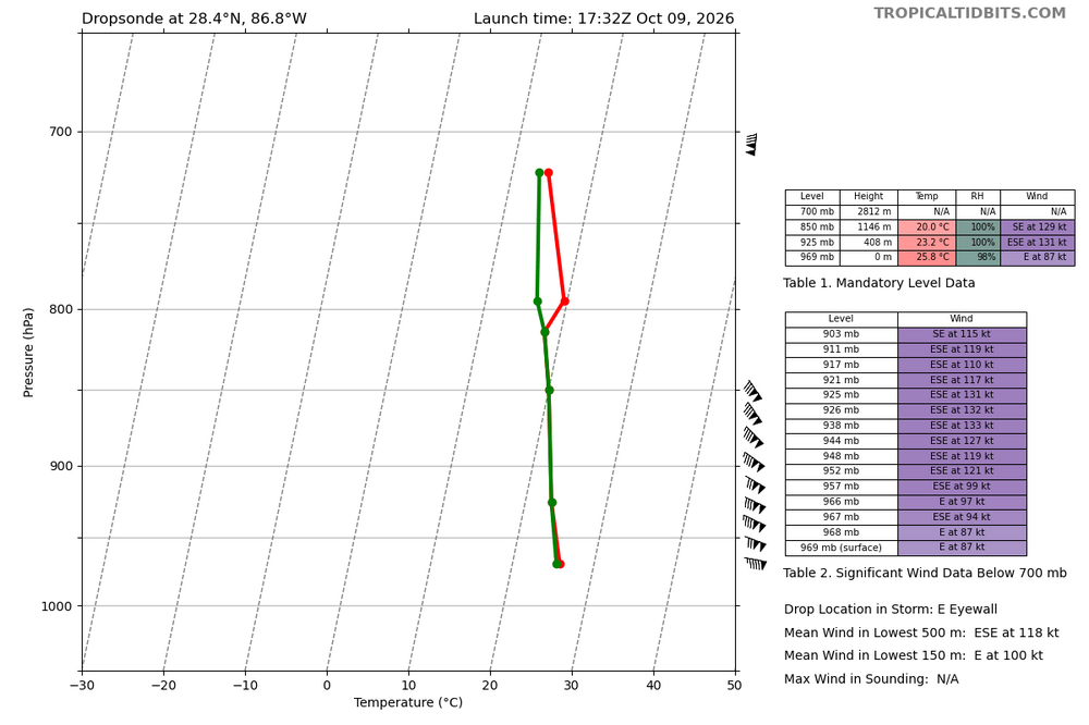
This wouldn't warrant an upgrade, but the data shows a storm that's pretty robust. 150 mph winds at 925mb-938mb, which is about 800-1200ft above the surface
-
I play in the men’s footy beer leagues on Sundays and it has been miserable. Pickups have been annoying enough, late summer but so far, 1st Sunday was pouring up until a few hours before and it was clear but it was ungodly humid. Like, I was sweating for an hour AFTER we were done. We canceled the weekend of the nor’easter, which probably would have been the best weather and the other two Sundays were raw and rainy. Couldn’t tell if it was sweat, rain, or both and took forever for my clothes and cleats to dry. Awful weather.
-
My 5 model blend for Augusta County has increased from 1.56" to 1.76". At the same time the NBM decreased from 1.02" to .82"! That NBM is a real party pooper considering how badly we need rain!!
-
Gotta take the over on this for most spots.
-
While I know it’s not a Helene, our area hasn’t really been tested since that storm. I’m nervous about what this could knock loose - both land and trees that may still be hanging by a thread.
-

2026-2027 Fall/Winter Mountain Thread
Met1985 replied to BlueRidgeFolklore's topic in Southeastern States
Map Sent from my SM-G998U using Tapatalk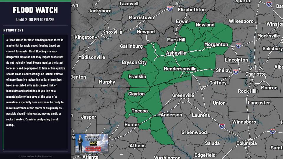
-
Damn you’re a young man. You should celebrate your bday and enjoy the warm autumn weather today and tomorrow.
-
Tuesday is going to be close to 80
-
Surprisingly the east eyewall drop only recorded 87kt surface level winds
-
It's easy to get nervous after what happened 2 years ago
-
Yep.
-
High end Forecast
-

2026-2027 Fall/Winter Mountain Thread
BooneWX replied to BlueRidgeFolklore's topic in Southeastern States
Ticking east every run. Good call. -
2026-2027 Fall/Winter Mountain Thread
Met1985 replied to BlueRidgeFolklore's topic in Southeastern States
Yup they finally pulled the trigger. Good thing as well. No need to wait until the last minute. People have PTSD from Helene. This storm looks legit for us folks. -
How many more wobbles east should I allow before I start to get nervous?
-

2026-2027 Fall/Winter Mountain Thread
yoda replied to BlueRidgeFolklore's topic in Southeastern States
Flood Watch National Weather Service Greenville-Spartanburg SC 200 PM EDT Fri Oct 9 2026 GAZ010-017-018-026-028-029-NCZ033-049-050-052-053-059-062>065- 501>510-SCZ101>104-100300- /O.NEW.KGSP.FA.A.0003.261010T1200Z-261011T1800Z/ /00000.0.ER.000000T0000Z.000000T0000Z.000000T0000Z.OO/ Rabun-Habersham-Stephens-Franklin-Hart-Elbert-Avery-Yancey-Mitchell- Haywood-Buncombe-Northern Jackson-Macon-Southern Jackson- Transylvania-Henderson-Caldwell Mountains-Greater Caldwell- Burke Mountains-Greater Burke-McDowell Mountains-Eastern McDowell- Rutherford Mountains-Greater Rutherford-Polk Mountains-Eastern Polk- Oconee Mountains-Pickens Mountains-Greenville Mountains- Greater Oconee- Including the cities of East Flat Rock, Celo, Ruckersville, Cove Creek, Cullowhee, Black Mountain, Marion, Fletcher, Cornelia, Walhalla, Glassy Mountain, Micaville, Dysartsville, Patterson, Newland, Canon, Cashiers, Boydville, Royston, Sylva, Little River, Canton, Fortsonia, Chimney Rock State Park, Sugar Hill, Hollywood, Ashford, Gumlog, Glenwood, Oakway, Hartwell, Hendersonville, Sawmills, Waynesville, Cedar Mountain, Swiss, Elberton, Highlands, Wolf Mountain, Forest City, Demorest, Valdese, Jonas Ridge, Ingalls, Lenoir, Tuxedo, Rocky Bottom, Busick, Brevard, Asheville, Etowah, Pleasant Grove, Old Fort, Nuberg, Banner Elk, Woodlawn, Nebo, Seneca, Toccoa, Poplar, Baldwin, Mountain Rest, Westminster, Kings Creek, Ramseytown, Columbus, Clarkesville, Dana, Cruso, Granite Falls, Waterville, Fero, Saluda, Burnsville, Reed Creek, Morganton, Rutherfordton, Mountain City, Middleton, Tuckasegee, Pine Mountain, Clayton, Franklin Springs, Candler, Lavonia, Tryon, Rainbow Springs, Mill Spring, Franklin, Spruce Pine, Spindale, and Kyle 200 PM EDT Fri Oct 9 2026 ...FLOOD WATCH IN EFFECT FROM SATURDAY MORNING THROUGH SUNDAY AFTERNOON... * WHAT...Flash flooding caused by excessive rainfall is possible. * WHERE...Portions of northeast Georgia, including the following counties, Elbert, Franklin, Habersham, Hart, Rabun and Stephens; portions of western North Carolina, including the following counties, Avery, Buncombe, Burke, Caldwell, Haywood, Henderson, Jackson, Macon, McDowell, Mitchell, Polk, Rutherford, Transylvania and Yancey; portions of Upstate South Carolina, including Oconee County, and mountainous northern portions of Pickens and Greenville Counties. * WHEN...From Saturday morning through Sunday afternoon. * IMPACTS...Excessive runoff may result in flooding of rivers, creeks, streams, and other low-lying and flood-prone locations. Creeks and streams may rise out of their banks. Low-water crossings may be flooded. * ADDITIONAL DETAILS... - As Isaias weakens and moves northward through the Mid-South early Saturday, rain will become increasingly likely across the western Carolinas and northeast Georgia. Periods of rain may begin over the watch area prior to dawn Saturday, though rainfall rates will initially be light. Rainfall rates will increase during the day, and heavy rain is most likely Saturday afternoon through early Sunday morning, particularly along the south and east facing Blue Ridge Escarpment, that is, near the southern border of North Carolina west of I-26, and in the sharp terrain from near Saluda to Grandfather Mountain in North Carolina. - http://www.weather.gov/safety/flood PRECAUTIONARY/PREPAREDNESS ACTIONS... A Flood Watch for flash flooding means there is a potential for rapid onset flooding based on current forecasts. Flash flooding is a very dangerous situation and may impact areas that do not typically flood. Please monitor the latest forecasts and be prepared to take action quickly should Flash Flood Warnings be issued. Rainfall of more than five inches in similar storms has been associated with an increased risk of landslides and rockslides. If you live on a mountainside or in a cove at the base of a mountain, especially near a stream, be ready to leave in advance of the storm or as quickly as possible should rising water, moving earth, or rocks threaten. Consider postponing travel along mountain roads during periods of heavy rainfall. -
Wind gust forecast starting to rise across the region for Sunday... now 30 to 35 mph.
-

2026-2027 Fall/Winter Mountain Thread
Maggie Valley Steve replied to BlueRidgeFolklore's topic in Southeastern States
Flood Watch issued for all of WNC including the Mountains. -
Still waiting on GSP to pull the trigger
-
For real. IMO based on recon we have a cat 4 just hours from landfall in a very populated part of Florida and some on here still think a nor Easter is going to be the end result.
-
BULLETIN Hurricane Isaias Intermediate Advisory Number 12A NWS National Hurricane Center Miami FL AL092026 100 PM CDT Fri Oct 09 2026 ...TROPICAL STORM CONDITIONS BEGINNING ALONG THE NORTHERN GULF COAST... ...PREPARATIONS AGAINST LIFE-THREATENING STORM SURGE AND DEVASTATING WINDS SHOULD BE COMPLETED IN THE NEXT COUPLE OF HOURS... SUMMARY OF 100 PM CDT...1800 UTC...INFORMATION ---------------------------------------------- LOCATION...28.4N 87.2W ABOUT 145 MI...235 KM S OF PENSACOLA FLORIDA ABOUT 125 MI...200 KM ESE OF THE MOUTH OF THE MISSISSIPPI RIVER MAXIMUM SUSTAINED WINDS...120 MPH...195 KM/H PRESENT MOVEMENT...NNE OR 20 DEGREES AT 16 MPH...26 KM/H MINIMUM CENTRAL PRESSURE...959 MB...28.32 INCHES
-
Most underhyped major cane I can recall. At least when it comes to this board and some of the weenie crowds. It's usually the opposite.
-
Curious to see if they got a good dropsonde in the eastern eyewall where those FL winds were just measured…the eye sonde continued to support 959mb, but those FL winds could support 110-115kt.
-
I think we’re getting some sting jet interaction. This very likely is cat 4 based on recon’s last pass of FL winds 130+ kts