All Activity
- Past hour
-
s tier color season incoming?
-
Hopefully Its weird not seeing any cold air anywhere in the long range gfs. I guess thats a Strong EL Nino for you.
-

Central PA Autumn 2026
Mount Joy Snowman replied to canderson's topic in Upstate New York/Pennsylvania
Low of 58 with .03" of rain from off-and-on all day drizzle yesterday. Looks like a splendid Fall week ahead. Onward. -
Now cherry (30%/70%): Tropical Weather Outlook NWS National Hurricane Center Miami FL 800 AM EDT Mon Oct 5 2026 Southwestern Gulf of America: A trough of low pressure in the southwestern Gulf of America is producing disorganized showers and thunderstorms. Although environmental conditions appear to be marginally conducive, gradual development is becoming more likely, and a tropical depression is likely to form during the middle or latter portion of the week. This system is expected to drift eastward over the next few days, before it turns northward. * Formation chance through 48 hours...low...30 percent. * Formation chance through 7 days...high...70 percent.
-
time to talk about snow that melted decades ago
-
Stein and boredom are back
-
 http://isocleardirect.com/# generic isotretinoin tablets
 -
Unfortunately it's that time of the year. URGENT - WEATHER MESSAGE National Weather Service State College PA 1233 AM EDT Mon Oct 5 2026 PAZ004-012-017>019-024-033-037-041-042-045-052000- /O.NEW.KCTP.FR.Y.0010.261006T0500Z-261006T1300Z/ Warren-Northern Clinton-Clearfield-Northern Centre-Southern Centre-Cambria-Somerset-Tioga-Northern Lycoming-Sullivan-Southern Clinton- Including the cities of Somerset, Trout Run, Laporte, Warren, DuBois, Renovo, Mansfield, Lock Haven, Johnstown, Wellsboro, Clearfield, State College, and Philipsburg 1233 AM EDT Mon Oct 5 2026 ...FROST ADVISORY IN EFFECT FROM 1 AM TO 9 AM EDT TUESDAY... * WHAT...Temperatures as low as 35 degrees will result in frost formation. * WHERE...A portion of central Pennsylvania. * WHEN...From 1 AM to 9 AM EDT Tuesday. * IMPACTS...Frost could harm or kill sensitive outdoor vegetation. PRECAUTIONARY/PREPAREDNESS ACTIONS... Those with agricultural interests should protect sensitive vegetation. Near-ground freezing temperatures could kill uncovered sensitive outdoor vegetation. The latest forecast information can be found on the NWS State College Facebook page and Twitter @NWSStateCollege, or on the web at weather.gov/ctp.
-
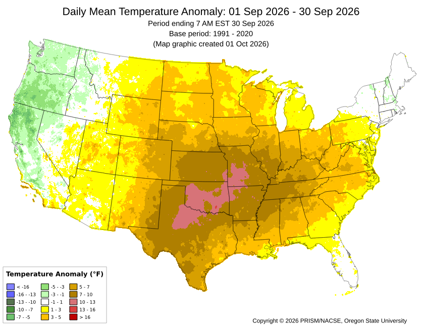
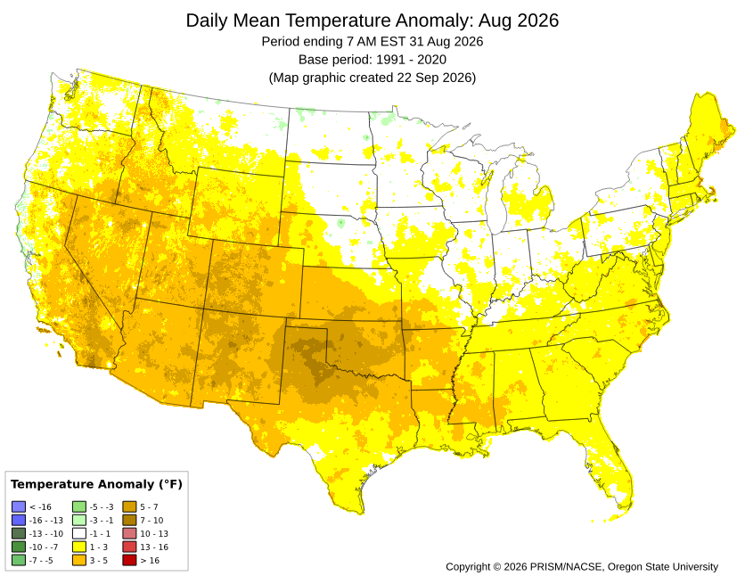
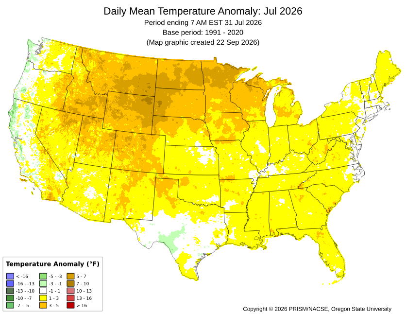
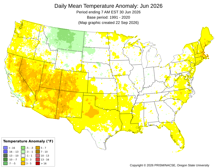
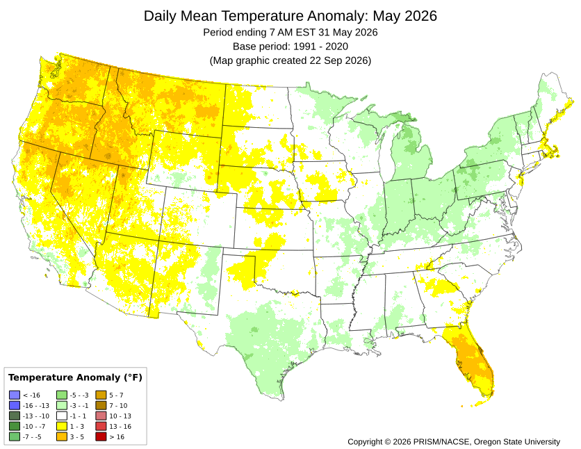
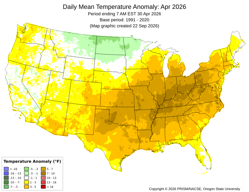
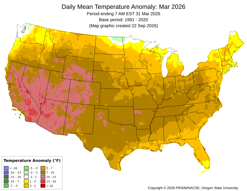
Last month was N to a little AN for most stations with the exception of the immediate Long Island Sound stations like BDR and LGA. All the other months back to March were also some degree of AN. With such extensive ridging and record CONUS warmth, there wasn’t much cooler air around. So the few cooler spots last month like LGA and BDR had to rely on lower daytime highs rather than cooler minimums. May managed to finish a little above even with the cooler conditions just to our West. The record warm day where parts of the area reached 100° for the first time in May put that month over the top. So the theme has been back and forth with the warmer departures being more impressive than the cooler ones. October looks like a continuation of the same theme. Very warm start to the month with a cool down this week. But we warm right back up into the 70s again. Whether we reach 80° again by mid-October will be contingent on sky conditions, wind direction, and how far north the moisture near the Gulf gets.
-
Drizzled/Misted all day and picked up .12. Finally was able to get in 2 baseball games.
- Today
-
Don't forget about 2002-03 to 2004-05. That was an epic 3-year stretch. Also, after 2009-10 and 2010-11, you had (after 2 lean years) 2013-14 and 2014-15 to complete the Big 4.
-
get generic avodart no prescription: dutashielddirect - cheap avodart for sale
-
Yeah, the right call was to go for it. What was wrong was the play call. The Eagles had total control of the game up until that point.
-
Get on it.
-
In 2022 the Vikings had a great record and a terrible point differential. That was the most obvious paper tiger in recent memory (they lost to Daniel Jones in the WC game). The 2026 Vikings have the 5th best point differential right now and the starting QB has been in the system two weeks (mostly without Jefferson). The D and ST are elite, but I have simply no idea whether the O can find a way this season. It is ugly so far.
-
I buck the tree into rounds and load onto my ATV trailer. Works out well . I bring it right to the splitter. Certainly not high volume but with my small ATV I can get almost anywhere.
-
Check out the record high for today.
-
zithromax generic cost and zithromax drug buy zithromax online australia http://clients3.weblink.com.au/clients/aluminalimited/priceframe1.aspx?link=https://rapidzithrodirect.com buy cheap generic zithromax or http://lenhong.fr/user/xqiuxnwqut/ generic zithromax 500mg [url=https://maps.google.co.ls/url?sa=t&url=https://rapidzithrodirect.com]zithromax for sale 500 mg[/url] where can i get zithromax and [url=https://bold-kw.com/user/gyanehihmb/?um_action=edit]zithromax online paypal[/url] zithromax cost
-
There was definitely some OE for sure.
-
get avodart pill or how to buy generic avodart without a prescription how to get cheap avodart prices https://images.google.by/url?q=https://dutashielddirect.com where can i buy avodart online and http://sotoycasal.com/user/ngdtneohrq/ cost of avodart without rx [url=http://www.aaronsw.com/2002/display.cgi?t=
-
can you get generic avodart online: DutaShield Direct - order avodart
-
https://cardiostatindirect.com/# lipitor 20mg price per pill
-
lipitor 20mg price per pill: CardioStatin - order generic lipitor 90 day supply
-
Up to 10/50% as of 1AM CDT advisory: Tropical Weather Outlook NWS National Hurricane Center Miami FL 200 AM EDT Mon Oct 5 2026 For the North Atlantic...Caribbean Sea and the Gulf of America: 1. Southwestern Gulf of America: A surface trough of low pressure has developed along the coast of Mexico in the southwestern Gulf of America. Although environmental conditions are expected to be only marginally conducive, gradual development of this system is possible and a tropical depression could form by the second half of this week while it initially drifts eastward before turning northward. * Formation chance through 48 hours...low...10 percent. * Formation chance through 7 days...medium...50 percent. Forecaster Papin