All Activity
- Past hour
-
36/35, cars getting frosty here too
-
Frosty cars when taking the dog out for her final walk. It seems like we will be getting a steady diet of radiational nights even if thicknesses are high. Large diurnal trends this time of year.
-
2026-2027 Fall/Winter Mountain Thread
Met1985 replied to BlueRidgeFolklore's topic in Southeastern States
Temp down to 39 degrees. -
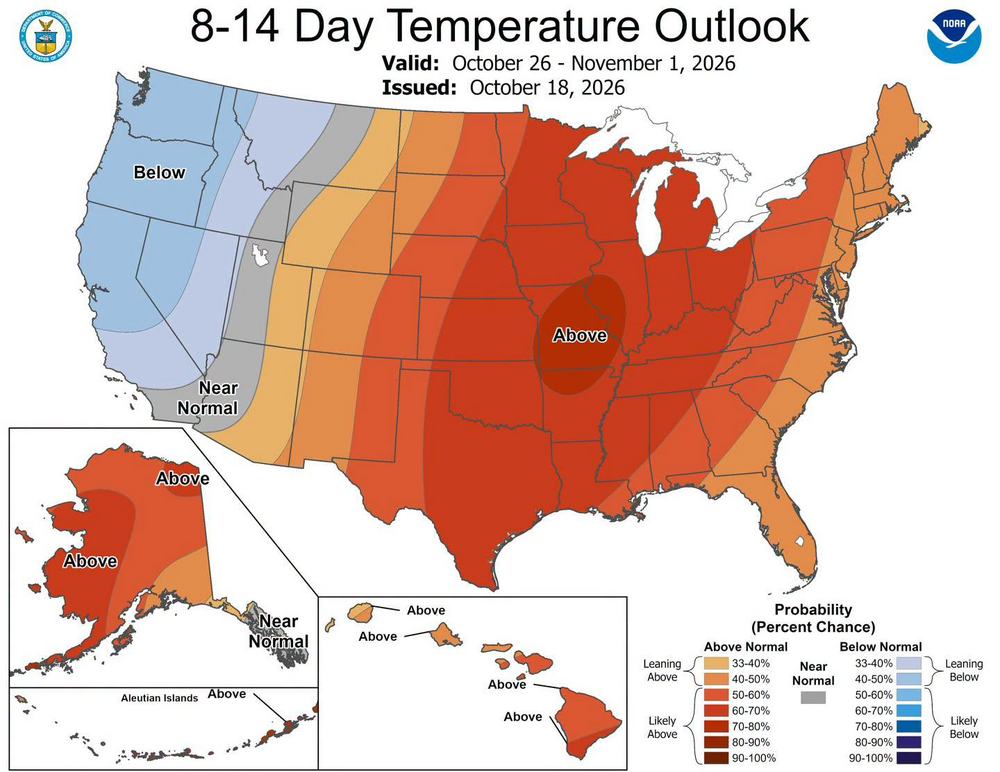
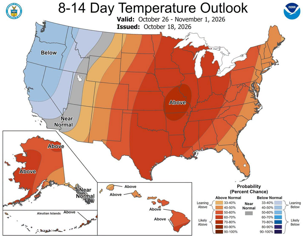
Only got 10 or so weeks but perhaps we can still break the US tornados by state record
-

2026-2027 Record-breaking El Nino
40/70 Benchmark replied to Stormchaserchuck1's topic in Weather Forecasting and Discussion
I wonder what @bluewavefeels about the fact that we haven't seen the big GOA low yet, and what that could mean if we don't... -
You got your freeze @John..lol.We was 4 degrees BN yesterday,would rather see some rain right now,looks like thats not going to work out very well the next 7-days
-
It’s like trying to trend into a warm week Wait next week
-
Beautiful pink asters. A great native fall perennial that should be used in place of non native mums. 34 at KFOK already. Forecast low of 35, likely makes it to the upper 20s in the pine barrens. .
-
2026-2027 Record-breaking El Nino
40/70 Benchmark replied to Stormchaserchuck1's topic in Weather Forecasting and Discussion
The only thing I like as much or more than cold and snow is getting the forecast right, so there is nothing worse than when I go cold/snowy and winter sucks...last thing I want. -
2026-2027 Record-breaking El Nino
40/70 Benchmark replied to Stormchaserchuck1's topic in Weather Forecasting and Discussion
Yea, the most likely outcome is it's just an exception to the October=winter N Pac pattern rule and it's just delayed. -
 Yeah I think the whole year is when you have the strongest event on record, and there are basically no negative H5 anomalies in the mean April to the present. Will be interesting to see if the pattern sets up for the 1st time as the N. Hemisphere Winter comes, it did happen for the S. Hemisphere Winter.
-
 For sure, it’s been shockingly cold in the Arctic this summer. So cold air is available to source. And anyone that claims to know exactly what is going to happen during an unprecedented event is just wishcasting. A very warm start, possibly record warm and of course wet is starting to lock in. After that the amount of uncertainty is off the charts. That’s why I think something like 83 or 16 is really on the table just as much as 73 or 98. .
-
2026-2027 Record-breaking El Nino
40/70 Benchmark replied to Stormchaserchuck1's topic in Weather Forecasting and Discussion
Heh...I just ran that narrative through AI and needed to go cyber-stroke after reading the response. All I can say is we had better get that pig GOA low soon. - Today
-
2026-2027 Record-breaking El Nino
40/70 Benchmark replied to Stormchaserchuck1's topic in Weather Forecasting and Discussion
Yea, October is usually telling for that....if we manage a cool ENSOish North Pacific, or hybrid type deal without MC tropical forcing...look out. -
Go NFC North! And Go Brewers starting Friday
-
Yeah I mean I'm 39F at 10pm. It's felt cool from the 2nd half of Summer on. I think there will be -AO tendency this Winter. And the N. pacific is looking nothing like El Nino right now... still.. told ya lol ENSEMBLE LOOP Will be interesting to see the N. pacific pattern this Winter. Monster low pressure likely won't dominate
-
I know. I get what you're saying. I just don't think this winter will act as hostile to cold/snow as worst case, at least not imby. And I also think the atmosphere is moving slower getting pieces in position thanks to the years of MC forcing and -PDO. That's why I'm more convinced with the formation of the Aleutian low than you. But as I said, time will tell and December will be here before you know it. Once Halloween hits, the holidays just fly by.
-

2026-2027 Record-breaking El Nino
GaWx replied to Stormchaserchuck1's topic in Weather Forecasting and Discussion
Thanks. Do you know whether or not it’s normal for +AAM to be prevalent within 30-50N at any point during a strong El Niño? Or does it tend to stick closer to the equator? Have you seen any actual data? The only other El Niño for which I can see latitude based relative AAM from this site’s data is 23-4 because it only goes back to 2022. Reviewing 23-4, the 30S to 30N region had the main +AAM only during Dec 1st-Jan 15th and it never exceeded +3 SD for any latitude. That paled in comparison to Sept 14th-Oct 3rd of ‘26, when it exceeded +4 SD in portions of 15S to 15N! -
2026-2027 Record-breaking El Nino
40/70 Benchmark replied to Stormchaserchuck1's topic in Weather Forecasting and Discussion
This season isn't as easy as people are making it out to be....aside from it's safe to say it won't average cold. This is my 13th one of these seasonal deals and this one has a lot more conflicting data than most make it seem. Last year was just about the easiest one I have had. -
I'm not saying it can't snow, if the Pacific neutralizes we can do it with -AO, which I think we will have some -AO this Winter. But I'm pointing out a very likely flaw: long term modeling in the N. Pacific.
-
Bottomed out at 40* this morning around 6:15am today Currently hanging at 48* at 950pm
-
2026-2027 Record-breaking El Nino
40/70 Benchmark replied to Stormchaserchuck1's topic in Weather Forecasting and Discussion
Literally every polar indicator looks great, so I do think it's unreasonable to expect a favorable window....is guidance overdoing it? Probably- -

2026-2027 Record-breaking El Nino
MJO812 replied to Stormchaserchuck1's topic in Weather Forecasting and Discussion
Be careful with that. We know weather does its own thing. Who knows maybe we will get decent blocking . -
2026-2027 Record-breaking El Nino
MJO812 replied to Stormchaserchuck1's topic in Weather Forecasting and Discussion
The sea ice and snow cover doesnt look bad at all in Canada. We never seen an El Nino this strong so we dont know what the outlook would be. Going to be an interesting winter for sure.