All Activity
- Past hour
-
2011 was the most unceremonious break I can recall. It wasn't a terribly long heat ordeal. ...Took maybe 2 or 3 days, but on that 3rd day my car's dash temperature read 108 F on Rt 9 at 55 mph just west of Framingham, obviously that's a blacktop park down there in that 1 story brick and mortar sprawl. NWS sites were 100 to 101 so ... At noon, DPs were close to 70 with temperatures already 96, then mid afternoon right at about 100 ... the DPs just shrank away. KFIT was left at 100 with a DP of 48... what? Meanwhile, HFD was still something like 101/74. Some sort of a quasi dry line had moved passed and evac'ed it all away. It was still hot as hell but the truly oppressive evening that day ended up down around southern zones the and Tristate region. I don't think I saw one cumulous cloud during that transition, either. The next day was bone dry at 83 or something banal
-
Do they make cloud panels for CAD land?
-
Yeah I’d prefer a little damage for a lot of people over devastating damage for just a few.
-
What a miserable fucking day
-
I think we'd all prefer a region-wide derecho vs. another 2011 or 1953
-
90's were a hotbed of 'rechos
-
Smokey. Can smell it and see it. I guess the NE breeze is a bit stronger. Didn't really notice anything earlier in the day.
-
Until tomorrow.
-
There's a interesting outflow boundary today in Texas. Some clear skies in the outflow, with scattered storms on the boundary.
-
EPS mean's making up for CC credits this spring... It's like what's been missing gets added in one 5 day stint. Under a solstice sun. zomb
-
Probably around the 24th-27th is a decent shot.
-
Yes.
-
I’m pretty confident that under 70 afternoons are gone from Monday on for a long spell. Let’s get some 95-102 days in here!
-
Got a little warmer here than I expected. Sun has finally made its appearance, though certainly not a blue sky kinda day. The lower visibilities are apparent when looking south towards Sugarloaf (which I can hardly see) and w/nw to the Catoctin's.
-
we have to look at 90 degree days to judge heat not average temperatures. In September 1983 for example, there were 7 90 degree days and a scorching 99 on September 11th. I wonder how many Junes have had 7 90 degree days and peaked at 99? Maybe a couple at most.
-
It's really like it begins now... From this point on you're gaining a little more summer vibes every day. Front on Thursday is a whisky variety ( severe?) and it's mostly a dry line ...setting stage for a synoptic roll out and the heat arrives.
-
I think he means a snowstorm to break the dews in December.
-
My statement was based off the already fake and overly warm latest climate normals.
- Today
-
Well the thing is.. there really is no end
-
Not sure where that is but SNE General was under .15. A terrible job by anyone calling for rain and using euro
-
hoping we can manage some big storms at the end of it
-
July 2, 1993 we had a split of 66/62 (actually similar to today with windy onshore flow and heavy rain.) A few days later we were off to the races with one of the most extreme heatwaves on record and one of the hottest summers on record, many of whose records still stand today (3 days in a row of 100+ at NYC, 5 days in a row of 100+ at EWR and 9 100+ days for the season at EWR, most 90 degree days at NYC with 39, tied 1991.)
-
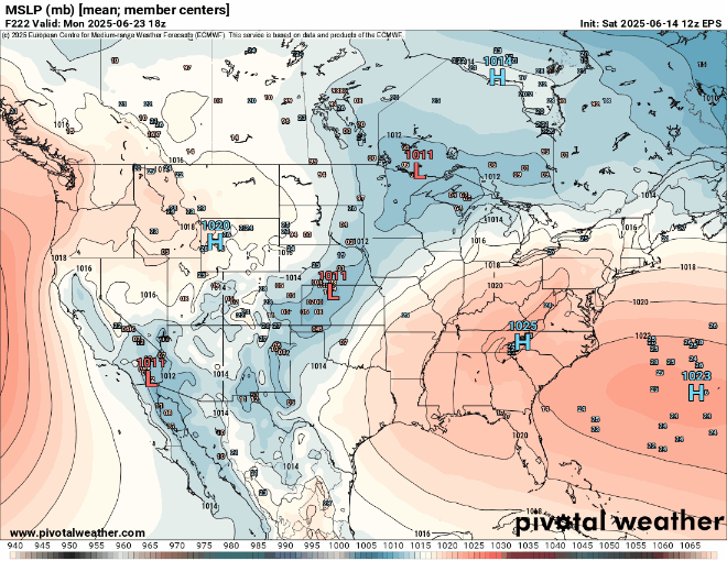
If we can keep the ridge from elongating too much into SE Canada in later runs, then a flatter EPS high like below will keep the flow more westerly.
-
Yes, I wonder if 1980 would be a good analog, I think we had big storms and big heat that summer. A late starting summer but it lasted a long time.
-
We have to look at recent trends more, September become a summer month now. Even October.


.thumb.png.4150b06c63a21f61052e47a612bf1818.png)


