All Activity
- Past hour
-
LOL you haven't learned yet that labeling almost anything as "toxic" IS toxic? Welcome to the 2020s
-

December 2025 regional war/obs/disco thread
Damage In Tolland replied to Torch Tiger's topic in New England
Everywhere should have that. -
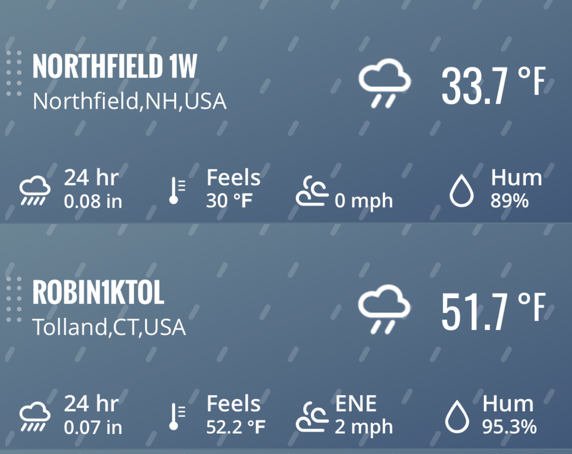
Heavy rain here this morning. 0.92" and still going.
-
December 2025 regional war/obs/disco thread
Damage In Tolland replied to Torch Tiger's topic in New England
I saw that lol -
Looks like BOx expanded HWW to the rest of SE MA like we talked about yesterday. Could be an interesting day around here.
-
LFG
-
53 outside. Temp rising faster than Kevin at bear week in Provincetown.
-
Nicer day yesterday than I expected, got to 7C/44.5F with some sun even peeking in the later aft hours. Lost a lot of snow. The rain started after dusk, in awe to find it was over 10mm/.4" of rain ugh. I just had it switch over to snow, roads look icy even before the flash freeze. WUN is showing xmas day around 3-5C and rain...
-
.thumb.jpg.6a4895b2a43f87359e4e7d04a6fa0d14.jpg)
Central PA Winter 25/26 Discussion and Obs
Yardstickgozinya replied to MAG5035's topic in Upstate New York/Pennsylvania
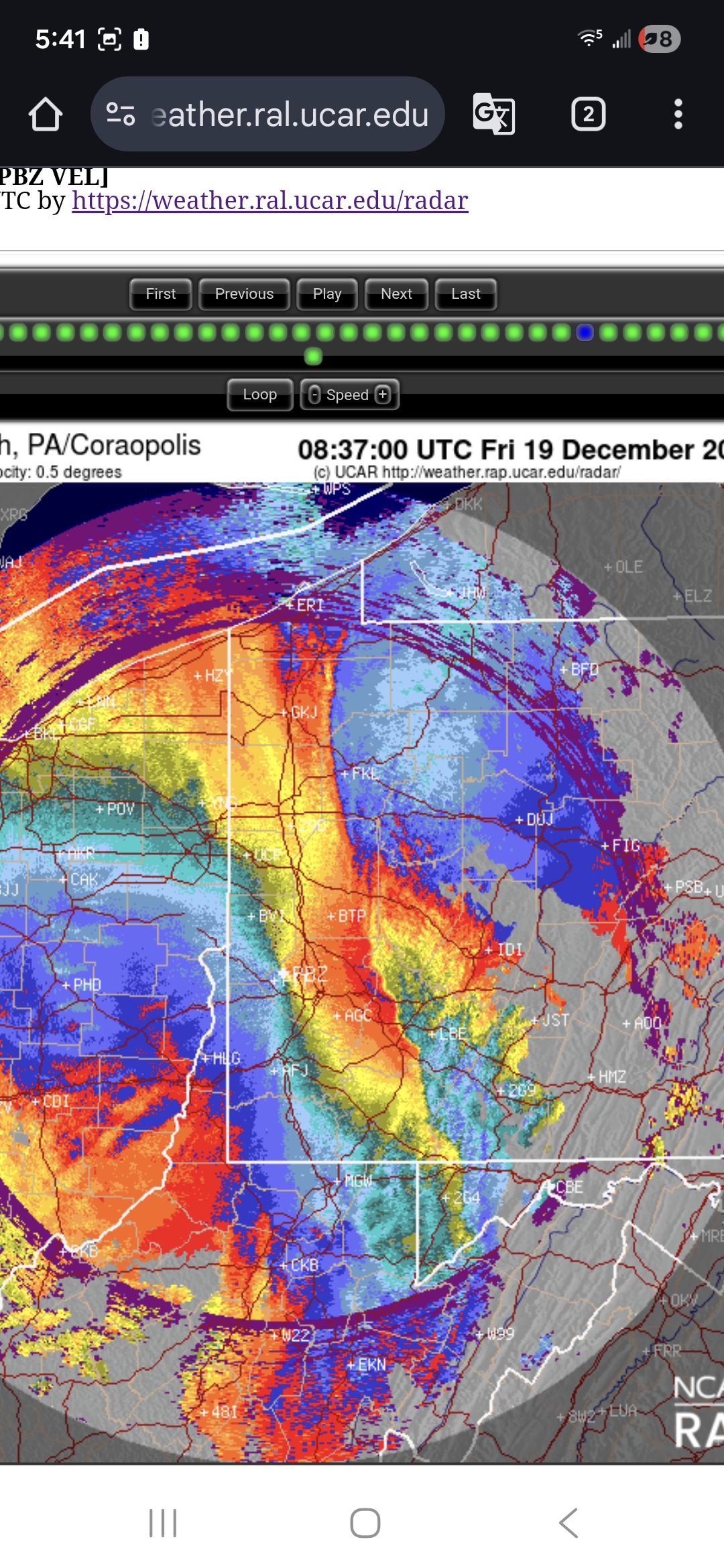
0.5 scan out of pittsburgh was definitely showing some bite at the ground from that band.
-

Central PA Winter 25/26 Discussion and Obs
mahantango#1 replied to MAG5035's topic in Upstate New York/Pennsylvania
-
Central PA Winter 25/26 Discussion and Obs
mahantango#1 replied to MAG5035's topic in Upstate New York/Pennsylvania
Patiently waiting to see if this squall line will make it through my area. Was looking forward to a thunderstorm. -
May have a nice squall as secondary cold front comes through in SNE. Hi res shows it this evening.
-
AI models are cooler fwiw on the 23rd. Hope for that especially SoP.
-
Hope for 1-3 on the 23rd and somehow makes it through Christmas Eve night when it finally goes below 32. Other than that overnight runs meh. What a pattern.
-
Central PA Winter 25/26 Discussion and Obs
Yardstickgozinya replied to MAG5035's topic in Upstate New York/Pennsylvania

-
Central PA Winter 25/26 Discussion and Obs
Yardstickgozinya replied to MAG5035's topic in Upstate New York/Pennsylvania
That said the lightning detection systems are plenty adequate enough to know that there's very little if any lightning occurring. -
6Z GFS still insisting on the 80s "Rain changing to snow before ending" this afternoon, and even looks to have a little Norlun weenie over Mnt.Tolland Also still has a decent signal for the 23rd, but I'd feel better if it would trend a little south
-
Central PA Winter 25/26 Discussion and Obs
Yardstickgozinya replied to MAG5035's topic in Upstate New York/Pennsylvania
Very little lightning downstream over the last twenty four hours. However, just because lightning is not detected does not mean it's not occurring. Parts of pennsylvania and the ohio valley do not have the best lightning detection systems.
-
ENSO thread says -NAO talk is jumping the gun and don’t expect any significant cold shots at the very end of the month…
-
Thanks a lot

-
Central PA Winter 25/26 Discussion and Obs
Yardstickgozinya replied to MAG5035's topic in Upstate New York/Pennsylvania
Trainingtimes Hrrr graphic has been fairly accurate in its depiction of a extremely narrow line of thunderstorms moving through Western Pennsylvania and the Ohio valley overnight. However, it has produced at no detectable lightning throughout the last several hours of its life cycle tonight. Furthermore the band has weakened as advertised. It'll be interesting to see if the Hrrr can continue it's accurate depiction of reinitiation of a narrow band as it moves through cpa. If it can get going again, it definitely looked like that kind of sharp narrow band that could have some gnarly winds this time of year. -

Central PA Winter 25/26 Discussion and Obs
Voyager replied to MAG5035's topic in Upstate New York/Pennsylvania
Don't forget 15 in Tamaqua...lol Not complaining, but my backyard is so sheltered by the neighborhood houses and the nearby mountains that I rarely get over 20 mph here -
Squeal line incoming
- Today
-

December 2025 Short/Medium Range Forecast Thread
Knoxtron replied to John1122's topic in Tennessee Valley
You guys weren't kidding on the winds, weather station recorded a 30 mph gust (only counts a 5 second avg for gust speed) and temp dropped 12 degrees in 5 mins from 1010 to 1015 last night Interesting that the winds were from the north all day and flipped 180 degrees to from the south in that time period. Whipping fog at 60 degrees in heavy wind is awesome weather haha -
Central PA Winter 25/26 Discussion and Obs
Yardstickgozinya replied to MAG5035's topic in Upstate New York/Pennsylvania
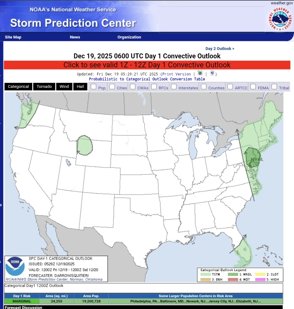
SPC AC 190529 Day 1 Convective Outlook NWS Storm Prediction Center Norman OK 1129 PM CST Thu Dec 18 2025 Valid 191200Z - 201200Z ...THERE IS A MARGINAL RISK OF SEVERE THUNDERSTORMS ACROSS PORTIONS OF THE MID ATLANTIC... ...SUMMARY... Isolated damaging winds may accompany convection over the Mid Atlantic today. ...Mid Atlantic... Late-evening water-vapor imagery depicts a notable midlevel trough over the MS Valley, shifting east in line with latest model guidance. This feature is forecast to take a more negative-tilt orientation by late morning as 100+kt 500mb speed max develops/translates across the Mid Atlantic by 18z. Impressive 12hr height falls at 500mb will overspread the OH Valley into New England where values will range from 240-300m in response to this strong feature. Needless to say, very strong wind fields will provide background support for organized frontal convection. HREF guidance is in general agreement that a narrow strongly forced line of convection will develop along the surging cold front early in the period. Forecast soundings do not exhibit more than weak SBCAPE with this frontal convection, but some mixing is expected given that 0-3km lapse rates should be on the order of 7 C/km. 40kt mean wind within this layer is expected to contribute to gusty winds with this activity. Have introduced MRGL Risk of damaging winds to account for strong gusts with a narrow line of convection that will surge east along the front. Given the limited buoyancy across southern New England will not introduce wind probabilities at this time. ..Darrow/Squitieri.. 12/19/2025 CLICK TO GET WUUS01 PTSDY1 PRODUCT NOTE: THE NEXT DAY 1 OUTLOOK IS SCHEDULED BY 1300Z CURRENT UTC TIME: 0944Z (4:44AM), RELOAD THIS PAGE TO UPDATE THE TIME