All Activity
- Past hour
-

October Comes Early: Late September Multi-Hazard Hybrid Storm
Spaizzo replied to WxWatcher007's topic in New England
It’s breezy here already in southern ct . -

Strong Nor'Easter/Hybrid Storm Late September 2026
MANDA replied to Rjay's topic in New York City Metro
NJ leadership has other issues going on. This is a case where they might actually need one. so we'll see when or if it comes. I think more when than if. -

October Comes Early: Late September Multi-Hazard Hybrid Storm
DirtySnowDen replied to WxWatcher007's topic in New England
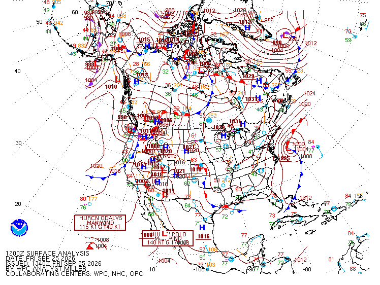
It is already dividing the high pressure symmetrically. -
 http://solmedsdirect.com/# mexico pharmacy ship to us
 -
October Comes Early: Late September Multi-Hazard Hybrid Storm
DirtySnowDen replied to WxWatcher007's topic in New England
-
Strong Nor'Easter/Hybrid Storm Late September 2026
MANDA replied to Rjay's topic in New York City Metro
This event is moving towards being very impactful over this subform. Been trying to keep my thoughts in check the last day or so not wanting to hype but this system has been throttling up the last 24-36 hours towards upper ranges of potential in all aspects. Coastal flooding and erosion, rainfall totals and wind potential have all ramped with each model cycle. Have been worried all along about major coastal flooding and that now seems likely at some locations. Winds have become a bigger factor as well especially over the more inland areas. Power outages could be widespread with wet ground and winds gusting to 50 mph+ along the coast and up to 40 mph more inland. Excessive rainfall totals now very possible over parts of the area. Some areas will not be able to take that much rain on top of what has fallen recently. Especially southern tier of CT and into NE NJ. Will be interesting to watch this unfold. Batten down the hatches if you are a coastal dweller. -

2026-2027 Record-breaking El Nino
Typhoon Tip replied to Stormchaserchuck1's topic in Weather Forecasting and Discussion
That seems diametrical to the current operation guidance, CMC/GFS/EURO All three have 564 to 570+ hydrostatic heights, with W to SW/NW off shore components, Wed thru Sat. Now ...this may differ from ens mean/bulk signaling and telecon indexes therefrom, et al... not sure, haven't checked. But, the operational runs are warmer than just mild those 4 days as of these last 00z guidance -

Strong Nor'Easter/Hybrid Storm Late September 2026
wthrmn654 replied to Rjay's topic in New York City Metro
Last thing it is a bit sandyish like, as we got closer and closer to the event, the tide forecasts kept ramping up and up and up Just like this one -
Strong Nor'Easter/Hybrid Storm Late September 2026
wthrmn654 replied to Rjay's topic in New York City Metro
The ironic thing about the coastal flooding situation, from past other storms events, my area usually lucked out from winds dying down earlier, or direction shift.... they usually were a little to high in there forecasts because they thought the models we underdone.. with this storm it would seem they think they're over done? Idk... with the storm more tucked in, and slow moving, south of Long Island and modeled to be stronger the wind directions are all changed, from a more north/ northeast, to now it being northeast, to a more easterly direction with at times some south depending on timing all of which is going funnel the crap into long island sound, gardiners/ peconic bay etc.. -

Strong Nor'Easter/Hybrid Storm Late September 2026
jdj5211 replied to Rjay's topic in New York City Metro
12Z Nam is wild so far...thing is just sitting off the Carolina coast and deepening.... -

Strong Nor'Easter/Hybrid Storm Late September 2026
NJwx85 replied to Rjay's topic in New York City Metro
There’s locations on the Jersey shore that didn’t fully recover for years. -

October Comes Early: Late September Multi-Hazard Hybrid Storm
WxWatcher007 replied to WxWatcher007's topic in New England
Yeah, for those following--this was never going to be purely tropical. We're talking about possibly a shallow warm core system. To be tropical it would need to shed the fronts it's attached to. But the title is what it is for a reason. We're talking hybrid here or maybe subtropical if things break right. Convection near the center, banding features, etc.. All that is still on the table once this really ramps up later today and tonight. As it stands however, we're all systems go. Good pressure falls are underway and our storm is organizing right where we want it. Big rainfall is still on the table along with significant winds especially along the coast. Euro is still most robust between it and the GFS on 925mb winds. Close call for mixing on the soundings. -

October Comes Early: Late September Multi-Hazard Hybrid Storm
dendrite replied to WxWatcher007's topic in New England
-

Strong Nor'Easter/Hybrid Storm Late September 2026
NorthShoreWx replied to Rjay's topic in New York City Metro
Most of the island was out for one to two weeks. Some mitigation. -
Strong Nor'Easter/Hybrid Storm Late September 2026
NJwx85 replied to Rjay's topic in New York City Metro
NWS is waiting on the 12z guidance. They still have time to enhance the warning package if things continue to escalate. -

Strong Nor'Easter/Hybrid Storm Late September 2026
SnoSki14 replied to Rjay's topic in New York City Metro
Models seem pretty locked in on this getting to LI or just south and heading due west into NJ a la Sandy. Obviously a much weaker version of that but could definitely result in major coastal flooding. Peak impacts are Sunday morning. A lot more rain than a Sandy solution given it'll be further north. -
October Comes Early: Late September Multi-Hazard Hybrid Storm
DirtySnowDen replied to WxWatcher007's topic in New England
The ballet/dance has begun. -
47.8 F for my low this morning!
-

Strong Nor'Easter/Hybrid Storm Late September 2026
WestBabylonWeather replied to Rjay's topic in New York City Metro
Haven’t started my generator in four years. I ran stabilizer through it after last use. Fingers crossed -

2026-2027 Record-breaking El Nino
GaWx replied to Stormchaserchuck1's topic in Weather Forecasting and Discussion
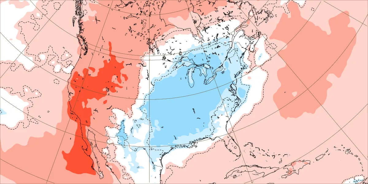
It’s looking pretty chilly in the E 1/2 of the U.S. next week (this is for Sep 28th-Oct 3rd):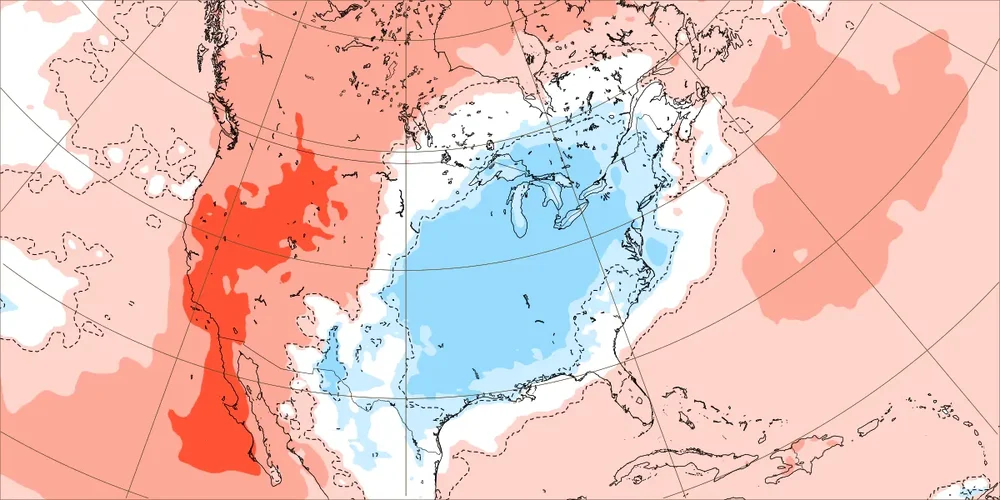
-
Strong Nor'Easter/Hybrid Storm Late September 2026
wthrmn654 replied to Rjay's topic in New York City Metro
I've bugged them enough this week. I'm on there real time slack group with other mets from media, emergency management etc... they didn't reply to my questioning why they issued coastal flood watch when there tide forecasts were mainly only minor... as the criteria is moderate to major. Asked if they saw the higher potential but didn't wanna issue yet? Crickets... -
Strong Nor'Easter/Hybrid Storm Late September 2026
NorthShoreWx replied to Rjay's topic in New York City Metro
Hopefully. It seemed like 97-98 had more nor'easters than any other winter. -
Strong Nor'Easter/Hybrid Storm Late September 2026
NJwx85 replied to Rjay's topic in New York City Metro
Consider yourself lucky. We had gusts to 100mph with Sandy and no power for 10 days. I was deployed to Seaside afterwards and the houses near the beach were pushed into each other like toys. Complete foundation failures. The main road in was blocked by a house that ended up there. And there were broken natural gas lines everywhere. It was truly a surreal experience. I’ll never forget being out the night of the storm when a 70 foot tree missed our truck by a few feet. That storm and riding out the mid Atlantic derecho in an RV in South Jersey were the scariest nights in my life. -

Septorcher 2026 Discussion - Endless Summer
Great Snow 1717 replied to Damage In Tolland's topic in New England
...September was suppose to be a month of endless summer according to some people lol -
October Comes Early: Late September Multi-Hazard Hybrid Storm
DirtySnowDen replied to WxWatcher007's topic in New England
I need some in-depth science. Would the cooler air OR water vapor enhancement add to intensity more? There is Beauty in the Beast.