All Activity
- Past hour
-
I’ve never heard/read one bad word about Dolly. Never! How many public figures can you say that about? Yes, one part of her anatomy was often made fun of but it was all in good fun and she seemed to enjoy the laughs.
-
Can you show me which stations in our sub-forum that is true for? This has not been an extremely hot summer, those surges of heat we had were short lived. This was a typical summer for the metro that featured warm and humid days and a stormy pattern starting after the 4th. It's interesting because if we had the inverse of this summer pattern happen in the winter (some extremely cold days mixed in with mostly average/warmer ones), you wouldn't have people going around saying that it's an icebox record cold winter.
-

2026-2027 Record-breaking El Nino
EasternLI replied to Stormchaserchuck1's topic in Weather Forecasting and Discussion
Yeah. You would expect to see some recurving typhoons instead of that. Key part of the puzzle IMO. Which we are still waiting for... -

2026-2027 Record-breaking El Nino
LakePaste25 replied to Stormchaserchuck1's topic in Weather Forecasting and Discussion
+PDO tends to be more indicative that the Pacific was in more of a nino state during the past 5-10 years and vice versa so that makes sense. Weak ENSO is going to have high variability. -
Looks like the Nino flatlined a little more than expected the last week or two. It's actually weakening considerably in 3-4. It may not quite peak as high as predicted. Regarding the PDO. Nino winters had positive PDO in something like 80 percent of moderate to strong ninos. 2023-24 was the only -pdo winter for one of them in the last 75 years.
-
 In some months the PDO correlates higher with US Temperature than ENSO. In a few months it actually scores higher than the PNA!
 -
2026-2027 Record-breaking El Nino
LakePaste25 replied to Stormchaserchuck1's topic in Weather Forecasting and Discussion
If this event doesn’t strongly couple then we need to start making PDO threads rather than ENSO threads. -

2026-2027 Record-breaking El Nino
jaxjagman replied to Stormchaserchuck1's topic in Weather Forecasting and Discussion
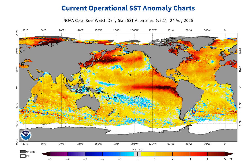
I agree with you,it dont seem like when the monthly updates you should see much change with a typhoon going into East China the next couple days.Look at how warm those SST's are east Japan into the Pac.Its rare in a strong NINO to even witness this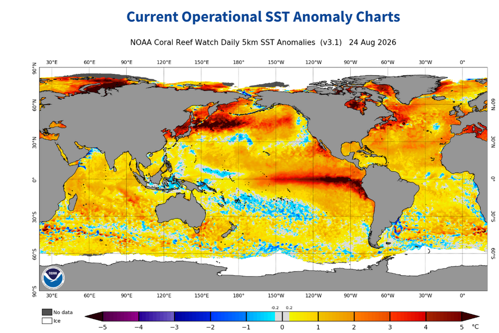
-
2026-2027 Record-breaking El Nino
EasternLI replied to Stormchaserchuck1's topic in Weather Forecasting and Discussion
Disagree that the odds are nearly zero. I do agree that the sheer magnitude of this el nino prevails. And I believe this autumn will do major work on that. However I also believe it is a true battle between the two. As the upper air pattern driving said PDO are fighting against it. PDO after all is a reflection of a predominant 500mb pattern. It takes effort to transform that as research shows. A major driver of this is known to be aleutian low variability. So it will be fascinating how that shakes out. The runaway strengthening on pause currently could be a little clue towards that. Or maybe not, but I would not be overly confident in either, and I am not. -
October 2024 PDO hit a 150-year low. Then in July 2025 it beat that, going lower. Now relative to ENSO it's probably just as impressive as Oct 2024 and July 2025. Don't think you can call a peak in the cold phase yet.
-

2026-2027 Record-breaking El Nino
40/70 Benchmark replied to Stormchaserchuck1's topic in Weather Forecasting and Discussion
This will couple more than 2024 at the height of the cold phase. - Today
-

Winter 2026-2027 Speculation
Prismshine Productions replied to 40/70 Benchmark's topic in New England
Man I am moving near a cliff don't do this to me Sent from my SM-S176V using Tapatalk -

2026-2027 Record-breaking El Nino
ensonerd1233e343 replied to Stormchaserchuck1's topic in Weather Forecasting and Discussion
thanks -
2026-2027 Record-breaking El Nino
40/70 Benchmark replied to Stormchaserchuck1's topic in Weather Forecasting and Discussion
https://www.data.jma.go.jp/tcc/tcc/products/clisys/figures/db_hist_3mon_tcc.html -
Something to consider as models show nearly a 6000dm ridge south of the Aleutian islands in 4-5 days, here are the last 3 El Nino Winters:
-
Yeah the GFS short to medium term backoff was expected, though the later window for recovery and potential intensification north of the islands is real. Future Dolly has the cards stacked against it in terms of making it to that pocket however. The shear is very real, as well as decreasing RH. Basin tenor has been very hostile this year, it just seems so much more likely that this fragile system will dissipate with a whimper. Some classic survivor bias within ensemble intensity forecasts down the line, and even that has been reduced as we've seen downtrending across the board today. Most AI ensemble members don't even show a TC anymore!
-
Everyone falls into the analog trap. 23-24 didn't couple and it peaked at +2.0c Here are the last 3 El Nino Winters:
-
PDO next update shouldnt change much with a typhoon headed into east China the next couple days.Maybe this winter will have its own analogs,but i wouldn't rely on a +PDO,probably wont happen ATM,thats rare in a strong NINO those SSTS east of Japan,lets go skiing in West Japan this winter?Very unique pattern regardless
-

Augdewst 2026: Summer's Last Stand
ineedsnow replied to Prismshine Productions's topic in New England
click around here and you can find the 1,000 ensemble run https://polarwx.com/tropical/#al962026/super also weathernerds.org is good -
2026-2027 Record-breaking El Nino
ensonerd1233e343 replied to Stormchaserchuck1's topic in Weather Forecasting and Discussion
still record breaking -
Kev... What site do you view Google Deep Mind tropical graphic?
-
2026-2027 Record-breaking El Nino
ensonerd1233e343 replied to Stormchaserchuck1's topic in Weather Forecasting and Discussion
Mine are 3.3-3.5 oni 2.4-2.6 roni so we agree for roni i just think the tropics will be warmer so the gap between roni and oni will be bigger -
2026-2027 Record-breaking El Nino
ensonerd1233e343 replied to Stormchaserchuck1's topic in Weather Forecasting and Discussion
I would say three years of la nina are likely -
2026-2027 Record-breaking El Nino
ensonerd1233e343 replied to Stormchaserchuck1's topic in Weather Forecasting and Discussion
I dont think it really is and either way the odds of el nino not coupling to the n pac during northen winter are near zero so imo the point is moot -
 https://northtrustpharm.com/# NorthTrust Pharm