All Activity
- Past hour
-
Reminds me of the Dec 2020 system somewhat. It won't be that intensity but it'll come down to it comes in like a wall or shredded. Feb's SWFE came in more like a wall and we had 4-6" for almost all. Dec 2020 came in shredded and it was still a very nice event here, but it was 8" vs 12+ because the shredded up precip shield allowed the warm mid level air to take over. We need this blocking to happen.
-
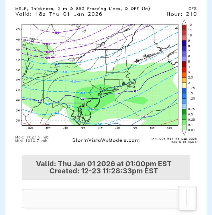
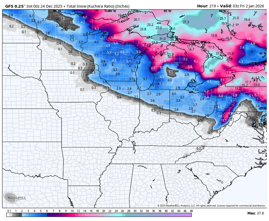
Gfs for NYD
-
A bit soon for a lock which is worrying. We got 8 more cycles to go for that. Might wobble some and expect it, so we will need to come back to ourselves and not get overly concerned. We don’t want big moves, thats for sure.
-

Winter 2025-26 Medium/Long Range Discussion
migratingwx replied to michsnowfreak's topic in Lakes/Ohio Valley
Well, this is an interesting development.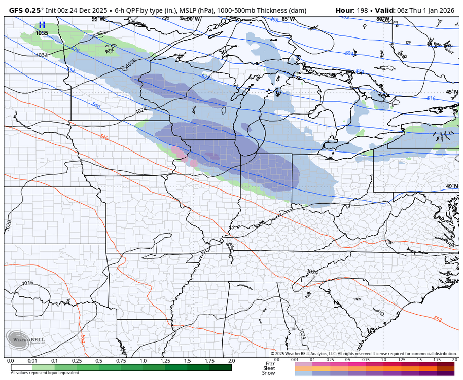
-
When the irresistible force meets the immovable object, someone could wind up under a death band even if the shortwave is a little sheared. Fun to track.
-

2025-2026 ENSO
so_whats_happening replied to 40/70 Benchmark's topic in Weather Forecasting and Discussion
Here is the latest subsurface from November to present. The wind anomalies have all but halted but things are primed if we get another solid weakening event of trades. Right now we are just maintaining the Nina SST profile. I will say it is fascinating to see how active the sun has been going into winter and us getting a pronounced -NAO periods showing up now multiple times..thumb.gif.2f198aeff236b0d0767d2751f47b4a8d.gif)
-
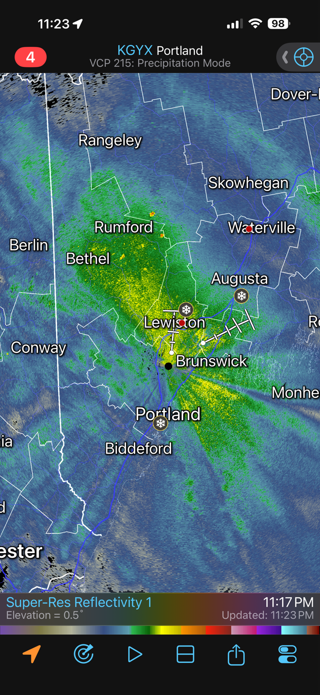
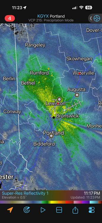
Its ripping, Closing in on 6"
-

White Christmas Miracle? December 23-24th
ma blizzard replied to Baroclinic Zone's topic in New England
1.3" 4.5" season to date -
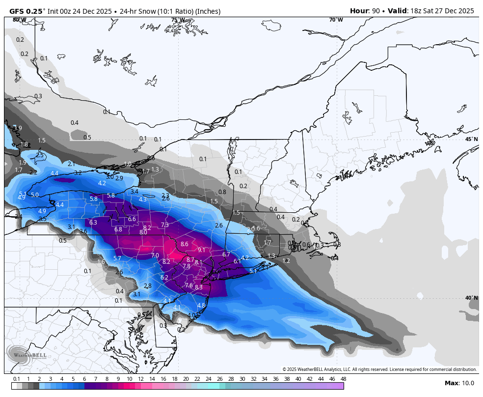
we need the GFS run to verify that's literally as good as it's going to get for this storm
-
.thumb.png.4150b06c63a21f61052e47a612bf1818.png)
26th-27th event, coming at us like a wounded duck.
HIPPYVALLEY replied to Go Kart Mozart's topic in New England
Looks good for NYC and S CT. Going to need a big turn tomorrow to get most of SNE in the game for more than 1"- 2" -
Gfs has that north trend on full display I was talking about that effs over Philly. For NYC, this is a good run but it needs to hold. Remember for the most snow, you need to sniff taint so roll the dice, city folks. Rooting for that to break the 4 inch shit streak down there for y’all.
-

White Christmas Miracle? December 23-24th
40/70 Benchmark replied to Baroclinic Zone's topic in New England
2.5".....looks like it's starting to taper a bit, as growth has eroded a bit... -
Yeah I do not think anyone as of NOW would go to rain. The GFS obviously at 78 hours shows a SE flow but that won't happen. The higher RES RGEM shows the CAD signature clearly in that same time period. We would need the surface low to go over like N NJ probably to see non frozen. The low is simply not deep enough and the high in too good a location any wind from like LI back into NNJ will be like 010-050.
-
I'm not saying you're wrong... And I appreciate that you are willing to stick your neck out and anticipate future model shifts. But I think it's worth noting that all ensemble guidance prior to 0z kept the heaviest precipitation well southwest of CT. Both the ECM-AI and GFS-AI also have done so for several cycles. I mention this because the ensembles and AIs have done well in the mid-range recently with precipitation distribution. We have not necessarily been seeing a northward shift in the short range. I can offer no particular reason to think this event will shift one way or the other... so I'm watching the ensembles means and spreads.
-
2025-2026 ENSO
so_whats_happening replied to 40/70 Benchmark's topic in Weather Forecasting and Discussion
Fun! Let us see if it shifts more west in time, as of this look Maine and Nova Scotia get the fun. -
Yep temps in the 20s
-
Blocking is strong . I can see the coast changing over to sleet at the very end but this looks like a moderate snowstorm.
-
All day long. Lets do it the GFS way this time.
-
I think the shortwave will ultimately gain enough latitude over the Upper MW its going to be insanely hard to force it so far south we can clear everything at 700/850.
-
These move north at the end so many times. The soundings and 700/850 tracks will matter and whether the snow comes in like a thump or shredded crap. I'm a little hopeful for MBY 30 miles east of Central Park but if this blocking lets up by a hair it's congrats this entire subforum while I drown in sleet. Hopefully there's a way we can all win.
-
what's your reasoning? most models including gfs have all the lows scoot way south of us and it's going to be way colder
-

Central PA Winter 25/26 Discussion and Obs
Blizzard of 93 replied to MAG5035's topic in Upstate New York/Pennsylvania
0z GFS shows heavy sleet for most of us on Friday. Warning level snow for northeast PA this run.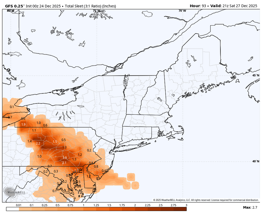

-
I believe in the end the metro changes over to sleet for a decent period with this. Still feel something like the RGEM or slightly NE happens but might get 3 plus before any changeover happens. The model bias game right now based on their positions would argue a line from like WRN LI NW up through NE NJ/SW NY is the bullseye but I think this may shift 30-50 miles NE in the end. If you asked me where I'd go now if I had to pick a spot to get slammed and I cannot move or change my mind once I pick it I'd go with Waterbury CT
-
looks 4-8
-

December 2025 regional war/obs/disco thread
SnowGoose69 replied to Torch Tiger's topic in New England
I felt 48 hours ago the place to be here would be SNE because I felt despite the block the shortwave would gain enough latitude over the Upper Midwest it would be hard to keep this forced that far SW. I still think something like the RGEM may happen and some areas of CT might do well between BDL and HVN and W-SW of there. I am of the belief still NYC changes over to sleet for a decent period and if that happens it probably means CT jackpots. RI/MA need more help than I think we're going to get.


.gif.67489d4eb9462e976c7ac38b7e4a1995.gif)