All Activity
- Past hour
-
Flash flood warning just issued for it. 1-2” per 30 min.
-
Storm stayed just to the northeast. Sun is popping back out again. Onto tomorrow…
-

July 2025 Obs/Disco ... possible historic month for heat
Snowedin replied to Typhoon Tip's topic in New England
If we ever surpass that threshold officially just once before this season has passed, I guarantee you I’ll be sitting outside with nothing but my shortest shorts, the most tropical inspired drink and the biggest grin on my face imaginable. -
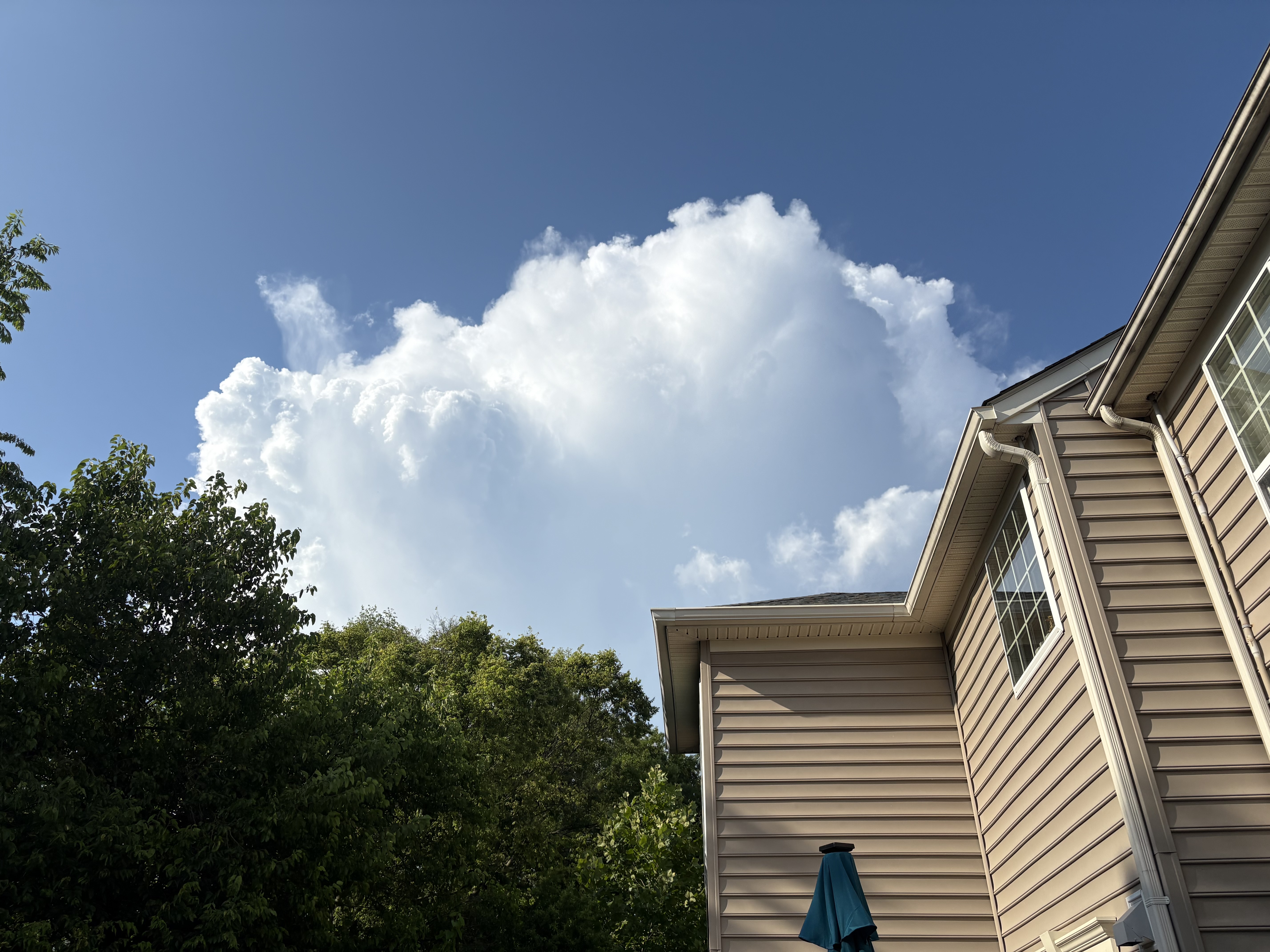
It’s actually backbuilding and now literally on my doorstep lol
-
2.45" so far in just under an hour. It was pouring for a while. Was outside when it started and thunder was nearly continuous. The first drops were like globules, akin to snow parachutes in winter. Was nearly stationary over Reston and Vienna as it blew up.
-
The thunder is intense...at least it cooled it off here even if it doesn't rain
-
Yeah they aren't moving much at all.
-

2025 Short Range Severe Weather Discussion
Spartman replied to Chicago Storm's topic in Lakes/Ohio Valley
Through tonight -

July 2025 Discussion-OBS - seasonable summer variability
Dark Star replied to wdrag's topic in New York City Metro
The LAST thing we need is a world government. Globalist are trying to take down this country. If you think the world might be a better place without the US, I don't think the rest of the world would agree. You don't see people flocking to Russia or China? -
1.5 miles from radar estimates of well over an inch. I’m at 0.05”.
-
We heard that down here as well. Had no idea anything was even out there. Here it is from my back deck looking N.

-
July 2025 Discussion-OBS - seasonable summer variability
Dark Star replied to wdrag's topic in New York City Metro
China has most of our manufacturing with a lot less of emissions control. -
It's teasing me I can feel the rain in the wind
-
Ended up hiking Billy Goat this morning (first time in a while). My drive home would have been a disaster if I hadn’t brought another shirt to wear. Looks like I went at the right time because the 270 split microclimate is cranking again. Also, have heard some decent thunder in the last few mins, but looks like that cell might stay to the north.
-
In between the "relentless rains," Dayton has done quite well with heat. Today was the 11th 90F+ reading of the season. Dating back to 1955 (71 years), that amount has only been exceeded through today's date (July 12) in 5 years (1966, 1988, 1994, 2012, and 2020). Through yesterday, the mean temperature was 6th highest in the threaded record. A little weird that they use the warmer, low elevation Miami Conservancy District building records for 1943 & 1944, instead of the higher elevation airport site. At the airport site, it has been the warmest since 1935, outpacing both of those years. Today's heat should help these numbers somewhat. The forecast calls for generally warm and summery weather conditions over the next several days, with highs forecast in the upper 80s tomorrow & Monday, near 90 on Tuesday and Wednesday, upper 80s Thursday, and perhaps cooling to the middle 80s by Friday.
-
Just ooze a bit this way…
-

July 2025 Discussion-OBS - seasonable summer variability
bluewave replied to wdrag's topic in New York City Metro
Yeah, the ridge axis was to our west. This is why JFK only has around half as many 90° days as NJ this year so far. The warm spots in NJ may very well top 40 days reaching 90° again this year. While the number to the east of NYC with the sea breeze will be much lower. The ridge axis has been located to the east of New England again this summer. 90° Day Data for January 1, 2025 through July 11, 2025 Click column heading to sort ascending, click again to sort descending. Newark Area ThreadEx 18 OCEAN COUNTY AIRPORT WBAN 18 NEWARK LIBERTY INTL AP WBAN 18 TETERBORO AIRPORT COOP 16 HIGHTSTOWN 2 W COOP 16 TETERBORO AIRPORT WBAN 16 CALDWELL ESSEX COUNTY AP WBAN 16 HARRISON COOP 16 PHILADELPHIA/MT. HOLLY WFO COOP 14 90° Day Data for January 1, 2025 through July 11, 2025 Click column heading to sort ascending, click again to sort descending. LAGUARDIA AIRPORT WBAN 13 New York-LGA Area ThreadEx 13 BAITING HOLLOW COOP 11 PORT JERVIS COOP 10 SARATOGA SPRINGS 4 SW COOP 10 POUGHKEEPSIE/HUDSON VALLEY REGIONAL AIRPORT WBAN 10 STONYKILL NEW YORK RAWS 10 Poughkeepsie Area ThreadEx 10 ST. JAMES COOP 10 DANSVILLE MUNICIPAL AIRPORT WBAN 9 JFK INTERNATIONAL AIRPORT WBAN 9 New York-Kennedy Airport Area ThreadEx 9 SARA NEW YORK RAWS 9 VICTOR 2NW COOP 8 LANSING MANOR COOP 8 WEBSTER 2 NE COOP 8 GANG MILLS NEW YORK RAWS 8 SHERBURNE NEW YORK RAWS 8 ISLIP-LI MACARTHUR AP WBAN 7 HUDSON CORRECTIONAL FACILITY COOP 7 DANSVILLE COOP 7 SYRACUSE HANCOCK INTL AP WBAN 7 WESTCHESTER CO AP WBAN 7 SHIRLEY BROOKHAVEN AIRPORT WBAN 7 Islip Area ThreadEx 7 Syracuse Area ThreadEx 7 FARMINGDALE REPUBLIC AP WBAN 6 NY CITY CENTRAL PARK WBAN 6 SHRUB OAK COOP 6 MONTGOMERY ORANGE COUNTY AP WBAN 6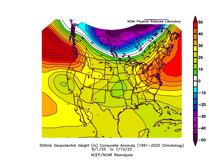
-
100%. This area is not meant to be dry with a northwest wind on a daily basis.
-
Daily PDO is hitting -3.4, they say that's the lowest daily they've ever seen. Last October the daily peaked at -3.0, and it resulted in a -3.8 monthly for October 2024, the lowest monthly reading on record going back to the 1800s.
-
It is very active in Haymarket right now!
- Today
-
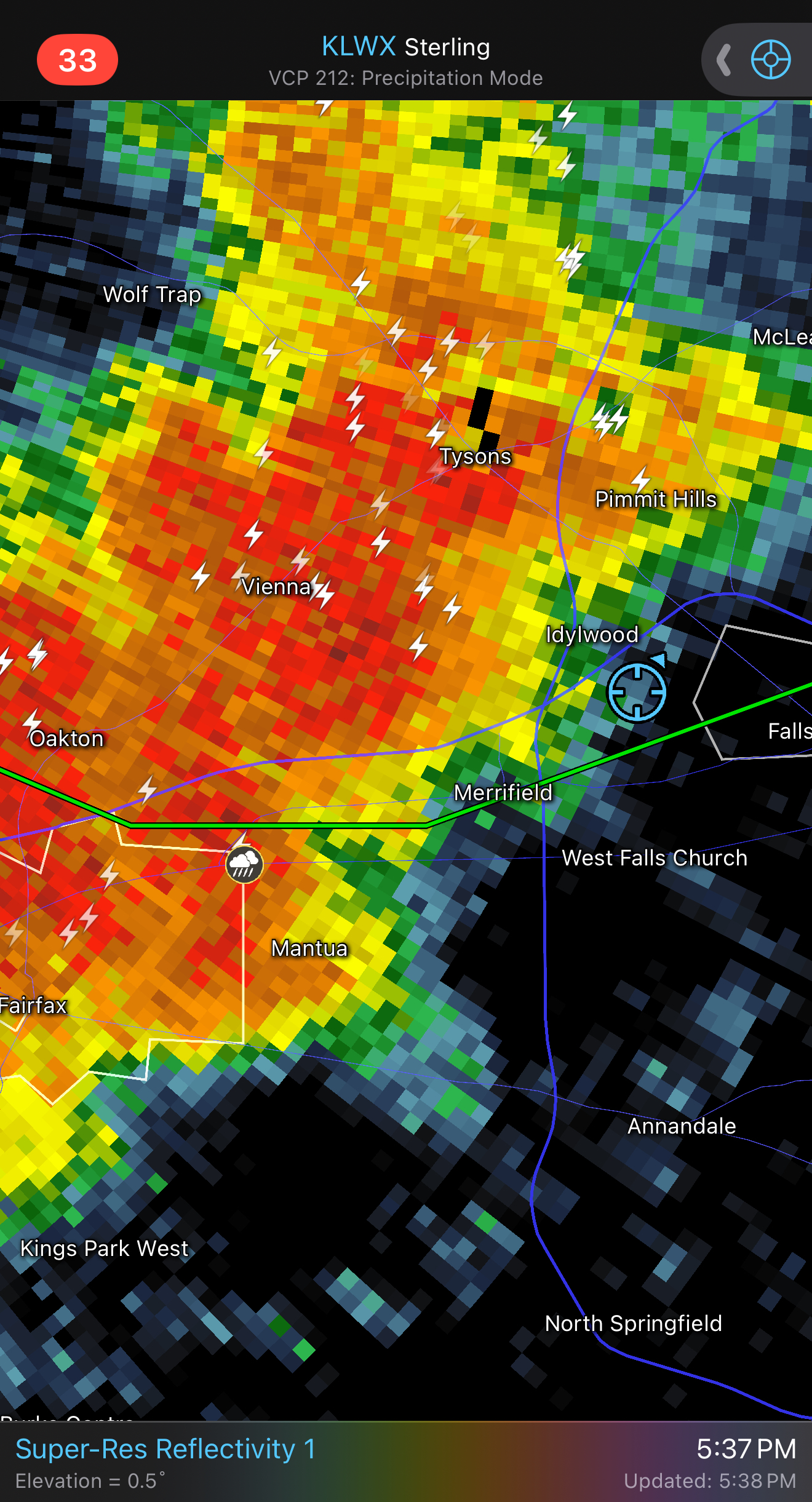
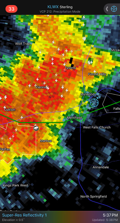
BULLETIN - EAS ACTIVATION REQUESTED Flash Flood Warning National Weather Service Baltimore MD/Washington DC 449 PM EDT Sat Jul 12 2025 The National Weather Service in Sterling Virginia has issued a * Flash Flood Warning for... South Central Montgomery County in central Maryland... West Central Arlington County in northern Virginia... Fairfax County in northern Virginia... The Northwestern City of Falls Church in northern Virginia... * Until 800 PM EDT. * At 449 PM EDT, Doppler radar indicated thunderstorms producing heavy rain across the warned area. Between 1 and 3 inches of rain have fallen. The expected rainfall rate is 1 to 2 inches in 30 minutes. Additional rainfall amounts of 1 to 2 inches are possible in the warned area. Flash flooding is ongoing or expected to begin shortly. HAZARD...Flash flooding caused by thunderstorms. SOURCE...Radar. IMPACT...Flash flooding of small creeks and streams, urban areas, highways, streets and underpasses as well as other poor drainage and low-lying areas. * Some locations that will experience flash flooding include... Arlington... Rockville... Bethesda... Reston... Herndon... Fairfax... Vienna... Falls Church... Pimmit Hills... American Legion Bridge... Mclean... Potomac... North Bethesda... Oakton... North Potomac... Tysons Corner... Wolf Trap... Great Falls... Merrifield... I66 and I495 Interchange...
-

July 2025 Discussion-OBS - seasonable summer variability
LibertyBell replied to wdrag's topic in New York City Metro
The only thing I can realistically compare it to is the December 1992 noreaster in terms of how intense it was and how long it lasted. The 1990s were chock full of extreme weather the likes of which we have not experienced since! -
Flash Flood Warning National Weather Service Baltimore MD/Washington DC 513 PM EDT Sat Jul 12 2025 The National Weather Service in Sterling Virginia has issued a * Flash Flood Warning for... Fairfax County in northern Virginia... South Central Loudoun County in northern Virginia... Prince William County in northern Virginia... * Until 815 PM EDT. * At 513 PM EDT, Doppler radar indicated thunderstorms producing heavy rain across the warned area. Between 1 and 2.5 inches of rain have fallen. The expected rainfall rate is 1 to 2 inches in 30 minutes. Additional rainfall amounts of 1 to 3 inches are possible in the warned area. Flash flooding is ongoing or expected to begin shortly. HAZARD...Flash flooding caused by thunderstorms. SOURCE...Radar. IMPACT...Flash flooding of small creeks and streams, urban areas, highways, streets and underpasses as well as other poor drainage and low-lying areas. * Some locations that will experience flash flooding include... Centreville... Bull Run... Sudley... Catharpin... Woolsey...
-
July 2025 Discussion-OBS - seasonable summer variability
LibertyBell replied to wdrag's topic in New York City Metro
This was the most intense and extreme heatwave I've ever experienced, both extreme in duration and intense in how long peak triple digit heat lasted. Most of the posters who didn't experience 1993 have no idea what kind of heat we had back then and have never experienced anything like it in our area! -
July 2025 Discussion-OBS - seasonable summer variability
LibertyBell replied to wdrag's topic in New York City Metro
Wow that's absolutely amazing Chris... is that the Bermuda High centered over SE PA? That's the equivalent of Sandy making landfall in S NJ, you rarely if ever see a track and position like that. Did the same thing happen in 1999 and 2002 during the very long heatwaves in those years too?