All Activity
- Past hour
-

July 2025 Discussion-OBS - seasonable summer variability
SACRUS replied to wdrag's topic in New York City Metro
76/ 69 clear. Great stretch of summery weather coming up, warm - hot today, mainly clear and dry - 80s - low 90s in the hotter areas. Passing storms tonight, look to stay mainly north and will make way for a gorgeous fourth of july - beach - bbq - bay - fireworks and outside dry- sunny warm mainly 80s / some 70s shores and north. Sat - mon - warm - hot / humid 80s to low/mid 90s in the hot areas - hottest looks monday - onshore component keeps heat focused inland. Beyond there overall warm - hot , humid and wetter - see onshore frequency. Way beyond continues to see ridge building heights east with heat following for a hot close. -

July 2025 Obs/Disco ... possible historic month for heat
jbenedet replied to Typhoon Tip's topic in New England
The mandarin off the southeast coast looks important to closely watch. At this moment still early but not for Cape and Islands. Some indirect impacts potentially as early as Sunday and —at risk of stating the obvious here— it’s a big beach/vacation weekend…. Both euro and GFS develop a weak tropical system within 72 hrs. Big ridge in the western Atlantic will preclude a quick escape east, so it will be close to the mid Atlantic/northeast coast at least through 120 hrs. We watch. -

2025-2026 ENSO
Stormchaserchuck1 replied to 40/70 Benchmark's topic in Weather Forecasting and Discussion
Well there's a lot of variables included. This is one of them. I posted some pretty cool PDO stuff a few pages back.. you are right, the later into Summer you go the more important some things are. A side note, but I do really like cold 500mb in any form.. I said this last year. We had almost the same exact strong +AO happening at this time last year, and it was the first time we had a cold 500mb sustained area in long time, I think the whole 2020-2023 period didn't have that. I was saying how it could possibly flip the EPO to negative for the Winter, and we did in fact have some -EPO driven cold. All these composites of best snowfall DCA seasons have cold 500mb all over the N. Hemisphere in the Fall before then.. it doesn't matter so much if there is PNA etc. just that there is widespread 500mb cold. I think it's a new pattern that we entered into last year. -
Tomorrow looks like a fantastic summer day with low humidity and reasonable temps.
-
I actually prefer the opposite.
-
-

2025-2026 ENSO
40/70 Benchmark replied to 40/70 Benchmark's topic in Weather Forecasting and Discussion
This composite below is strongly QBO and solar derived. -

July 2025 Obs/Disco ... possible historic month for heat
CoastalWx replied to Typhoon Tip's topic in New England
Just the start -
2025-2026 ENSO
40/70 Benchmark replied to 40/70 Benchmark's topic in Weather Forecasting and Discussion
I think February could be pretty balmy before some potential late season stratospheric shennanigans- -
I get it, but it's going to miss a whole lot of changes is SSTA, solar, and other variables before winter arrives, so at this range it's hard to get excited one way or the other. Then again, it's hard to get excited over anything at this range.
-
2025-2026 ENSO
40/70 Benchmark replied to 40/70 Benchmark's topic in Weather Forecasting and Discussion
Notice the two steps forward, one step back type of progression towards the shift back to a warmer Pacific phase that occurred in both 2000 and 2012, where as 2000-2001 flipped strongly positive before 2001-2002 was negative again....2012-2013 was strongly positive and 2013-2014 flipped negative again. This is what I expect to see moving forward....next year will be negative again, but change is afoot IMHO. Its a several year process that will take the latter portion of this decade, but after that we should also be approaching solar min. -
2025-2026 ENSO
40/70 Benchmark replied to 40/70 Benchmark's topic in Weather Forecasting and Discussion
This is also added support for poleward Aleutian ridging....looks alot like more early polar composite. -
2025-2026 ENSO
40/70 Benchmark replied to 40/70 Benchmark's topic in Weather Forecasting and Discussion
Interesting....since 1950, I have 1955-1956, 1971-1972, 1974-1975, 1984-1985, 1999-2000, 2008-2009, 2011-2012, 2017-2018 and 2021-2022 as second year La Nina evemts. The only two DM periods that did not average -PNA out of that data set are 1999-2000 and 2011-2012, which preceeded swings back towards Pacific warm phase from cold phase. 2021-2022 actually had an extensive mid season +PNA mismatch period, but the seaonal mean was biased negative due to the the very stout RNA that ruined December....I could see a similar outocme this season with perhaps not as promounced -PNA, as that was record setting. -
2025-2026 ENSO
Stormchaserchuck1 replied to 40/70 Benchmark's topic in Weather Forecasting and Discussion
I'm going with a colder than average March, and probably above average Dec-Feb. -
2025-2026 ENSO
Stormchaserchuck1 replied to 40/70 Benchmark's topic in Weather Forecasting and Discussion
There's enough data where it works as per the correlation coefficient. It's /1 so 0.1 is +10%, or 55% chance. 0.3 is +30%, or 65% chance. 0.5 is +50%, or 75% chance. Etc. -
That was us yesterday. Hours of thunder through the afternoon and evening but not a drop of rain. Two days ago we got a very brief (~30 sec or so) light shower but I couldn't tell where it was coming from. All of us at the neighborhood pool were looking around like "where's the cloud?" and laughing about it. All I can figure was the winds were blowing it around pretty good on the way down...
-
2025-2026 ENSO
40/70 Benchmark replied to 40/70 Benchmark's topic in Weather Forecasting and Discussion
Right...its not a perfect 1 correlation because nothing is...doesn't mean there isn't predictive value to be gleaned. -
2025-2026 ENSO
40/70 Benchmark replied to 40/70 Benchmark's topic in Weather Forecasting and Discussion
Incidentally, this is in perfect alignments with my thoughts. Thanks. -
Roll forward didn't work last year, so we're back to "who knows."
-

July 2025 Obs/Disco ... possible historic month for heat
kdxken replied to Typhoon Tip's topic in New England
Sunday and Monday look to be scorchers. Hopefully that'll be it for a while. - Today
-

July 2025 Discussion-OBS - seasonable summer variability
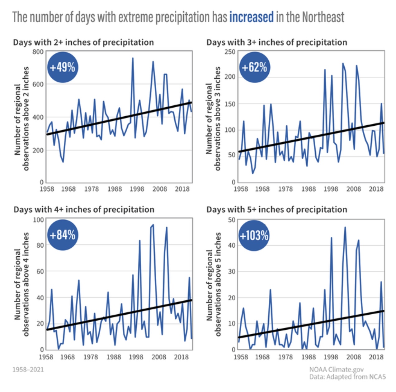
bluewave replied to wdrag's topic in New York City Metro
Doesn’t look like we will be switching to a drier pattern like that’s anytime soon since the pattern has become so much wetter in the last 20 years. Flooding has been more of a concern here than drought. Models backing off the heat next week due to the tropical low moving up the coast. Makes sense since past instances of 103°-105° heat didn’t have a return to near 100° so soon. New run Old run

-
2025-2026 ENSO
40/70 Benchmark replied to 40/70 Benchmark's topic in Weather Forecasting and Discussion
Agree.... -
recent warm stretch has done work getting lake water into shape for holiday weekend swimming, should be on track for about 80 by later in the month
-

E PA/NJ/DE Summer 2025 Obs/Discussion
Mikeymac5306 replied to Hurricane Agnes's topic in Philadelphia Region
Not looking like an ideal week in the Outer Banks next week for my vacation -

July 2025 Obs/Disco ... possible historic month for heat
NoCORH4L replied to Typhoon Tip's topic in New England
Cold, and 10 mph a little windy