All Activity
- Past hour
-

Potential Tropical Cyclone Nine
Wannabehippie replied to WxWatcher007's topic in Tropical Headquarters
Still looks like a mess on recent still color enhanced satellite photos. No closed center that I see. -
BULLETIN Potential Tropical Cyclone Nine Advisory Number 1 NWS National Hurricane Center Miami FL AL092025 500 PM EDT Fri Sep 26 2025 ...TROPICAL STORM WATCHES AND WARNINGS ISSUED FOR PORTIONS OF THE BAHAMAS... SUMMARY OF 500 PM EDT...2100 UTC...INFORMATION ---------------------------------------------- LOCATION...20.9N 74.6W ABOUT 55 MI...90 KM NNW OF THE EASTERN TIP OF CUBA ABOUT 200 MI...325 KM SSE OF THE CENTRAL BAHAMAS MAXIMUM SUSTAINED WINDS...35 MPH...55 KM/H PRESENT MOVEMENT...NW OR 305 DEGREES AT 9 MPH...15 KM/H MINIMUM CENTRAL PRESSURE...1008 MB...29.77 INCHES WATCHES AND WARNINGS -------------------- CHANGES WITH THIS ADVISORY: The government of the Bahamas has issued a Tropical Storm Warning for the central Bahamas and a Tropical Storm Watch for portions of the northwestern Bahamas. SUMMARY OF WATCHES AND WARNINGS IN EFFECT: A Tropical Storm Warning is in effect for... * Central Bahamas, including Cat Island, the Exumas, Long Island, Rum Cay, and San Salvador. A Tropical Storm Watch is in effect for... * Portions of the northwestern Bahamas, including Eleuthera, New Providence, the Abacos, Berry Islands, and Grand Bahama Island. A Tropical Storm Warning means that tropical storm conditions are expected somewhere within the warning area, within 36 hours. A Tropical Storm Watch means that tropical storm conditions are possible within the watch area, generally within 48 hours. For storm information specific to your area, please monitor products issued by your national meteorological service. Interests in eastern Cuba, the southeast Bahamas, the Turks and Caicos Islands, and the southeastern U.S. should monitor the progress of this system. DISCUSSION AND OUTLOOK ---------------------- At 500 PM EDT (2100 UTC), the disturbance was centered near latitude 20.9 North, longitude 74.6 West. The system is moving toward the northwest near 9 mph (15 km/h). A north-northwestward motion is expected during the next few days. On the forecast track, the center of the system is expected to track across the central and northwestern Bahamas this weekend and approach the southeast U.S. coast early next week. Maximum sustained winds are near 35 mph (55 km/h) with higher gusts. Gradual strengthening is forecast, and the system is expected to become a tropical depression on Saturday and a tropical storm Saturday night or early Sunday. * Formation chance through 48 hours...high...90 percent. * Formation chance through 7 days...high...90 percent. The estimated minimum central pressure based on surface observations is 1008 mb (29.77 inches). HAZARDS AFFECTING LAND ---------------------- Key messages for Potential Tropical Cyclone Nine can be found in the Tropical Cyclone Discussion under AWIPS header MIATCDAT4 and WMO header WTNT44 KNHC. WIND: Tropical storm conditions are expected in the tropical storm warning area beginning Saturday night and are possible in the watch area on Sunday. RAINFALL: The disturbance is expected to produce the following storm total rainfall amounts through Monday morning. Eastern Cuba: 8 to 12 inches, with isolated maximum totals of 16 inches possible. Bahamas: 4 to 8 inches of rain are expected. Hispaniola, Jamaica, and portions of central and southern Cuba: 2 to 4 inches of additional rainfall are expected. This rainfall will likely produce flash and urban flooding. Mudslides are also possible in areas of higher terrain across eastern Cuba, Hispaniola, and Jamaica. An increasing threat of heavy rainfall from this system is forecast over the southern Mid-Atlantic through coastal Georgia which could cause flash, urban, and river flooding into next week. For a complete depiction of forecast rainfall and flash flooding associated with Potential Tropical Cyclone Nine, please see the National Weather Service Storm Total Rainfall Graphic, available at hurricanes.gov/graphics_at4.shtml?rainqpf. STORM SURGE: A storm surge will raise water levels by as much as 1 to 3 feet above ground level along the immediate coast in areas of onshore winds in the northwestern Bahamas. Near the coast, the surge will be accompanied by large waves. SURF: Swells generated by both this system and Hurricane Humberto will affect portions of the Bahamas this weekend, and spread to portions of the southeast U.S. coast early next week. These swells are likely to cause life-threatening surf and rip current conditions. Please consult products from your local weather office. A depiction of rip current risk for the United States can be found at: hurricanes.gov/graphics_at4.shtml?ripCurrents NEXT ADVISORY ------------- Next intermediate advisory at 800 PM EDT. Next complete advisory at 1100 PM EDT. $$ Forecaster Cangialosi
-
With Humberto rapidly intensifying today, another MH is on the board. Peak Season Forecast (Aug 20-Oct 20) Named Storms: 10 (3) Hurricanes: 6 (2) Major Hurricanes: 3 (2) Fernand, Gabrielle (MH), Humberto (MH)
-

Potential Tropical Cyclone Nine
WxWatcher007 replied to WxWatcher007's topic in Tropical Headquarters
Taking a look at our coming PTC. Thanks to @Nibor for showing me how to post larger gif animations. You can clearly see both the gradual organization and headwinds for the coming PTC 9. To the north, you can see arc clouds still radiating out of the area, indicating the presence of some dry air. You can also see some of the thunderstorm tops being sheared, although it does look like in recent frames that things may have slackened some. It's easier to see the larger scale spin, and recon is on the way to examine how well defined a low level center there is. For a relatively short term forecast, there is still a lot to be figured out. -
Humberto is now a Cat 3. SUMMARY OF 500 PM AST...2100 UTC...INFORMATION ---------------------------------------------- LOCATION...22.3N 58.1W ABOUT 430 MI...690 KM NE OF THE NORTHERN LEEWARD ISLANDS MAXIMUM SUSTAINED WINDS...115 MPH...185 KM/H PRESENT MOVEMENT...WNW OR 295 DEGREES AT 5 MPH...7 KM/H MINIMUM CENTRAL PRESSURE...962 MB...28.41 INCHES
-
NHC will initiate advisories on Potential Tropical Cyclone Nine (formerly AL94), located near eastern Cuba, at 500 PM EDT (2100 UTC).
-
Wonder if he's gonna apologize for the "spoiled" comment, lol (I mean I happen to agree with him but it was really, really bad timing)
-
AI models are interesting for next weekend.. we watch
-
Well I think he was implying that it formed as a result of the event rather than necessarily during it. His name is Paul Roundy and has a lot of neat papers on seasonal climatology fyi. I can ask about the details next class if you want, don't fully know myself tbh.
-
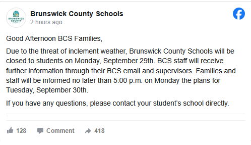
Schools closed Monday in Brunswick County NC (most southern county)
-
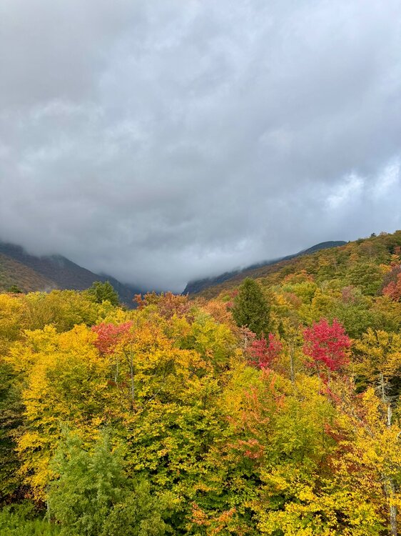
colors are really exploding here.. some areas look great.
-
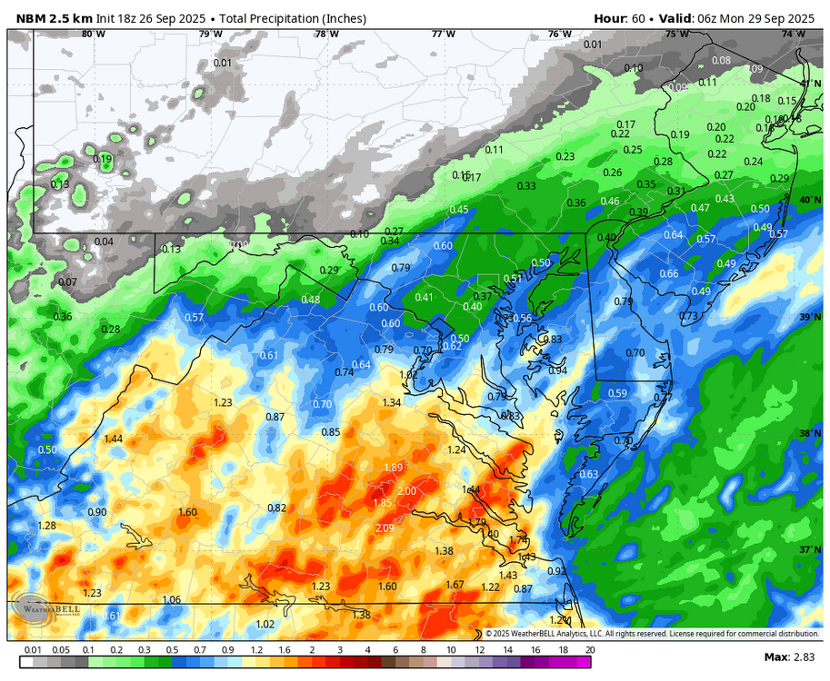
Also can take more precip, refer to Flash Flood Guidance. The terrain causes extra problems..8 inches of rain in NC is very different than Sofla.
-
Should have PTC 9 at the 5pm or 8pm advisory at the latest, it's coming up on Tomer Burg's site as a PTC now. By the way, some really nice value added products on his tropics site: polarwx.com/tropical
-
Brunswick County NC schools closed Monday.

-
Going be interesting to see if the AI models can be good like what they did for Erin, again.
-
 Kraychav changed their profile photo
 -
Google models look to mainly stay offshore then go up coast in various ways to. https://www.weathernerds.org/models/genc.html?&inittype=zoom&initfield=SST_Anomaly_Surface&initcycle=determine&initfhour=120&initimdimx=1050&initimdimy=630&initrange=55.000000000000:230.000000000000:20.000000000000:300.000000000000&initcx1=NaN&initcy1=NaN&initcx2=NaN&initcy2=NaN&initcross=False&initsound=False&initsoundx=429&initsoundy=291&initloop=True&initoverlay=False&initlstart=000&initlend=360&initlint=6&initol1=SST_Anomaly_Surface&initol2=null&initol3=null&initol4=null&initol5=null&initcities=Off&inithgwys=Off&inittracks=On&initlows=On&initlatlon=Off
-
We’ve started some color here but it was definitely behind what I saw in SVT elevations last week. This is right now up here.
-
Extremely dry can lead to extreme run off until the ground gets moist enough to absorb rain.
-
I feel like it’s always stick season in the mtns for that weekend. Peeps are always like a good week late.
-
Total noob here. I follow this board pretty closely for weather info, and I understand about 10% of what I read. However, I'm learning. This comment really caught my eye. I was at Ground Zero for Matthew (and Florence) here in southeastern NC. I mean, we had Jim Cantore in our town and everything. One if the biggest issues with Matthew was that we'd had a lot of rain prior to that storm. Right now, however, it is extremely dry in most of our part of the state. I assume that would make a huge difference when comparing potential outcomes of this storm to Matthew, or am I totally off base?
-
Funny no one's talking about the 12z euro ai run...... Doesn't come to shore anywhere it lingers south until the high to north weakens and comes to the north east around 983 mb close to long island...
-
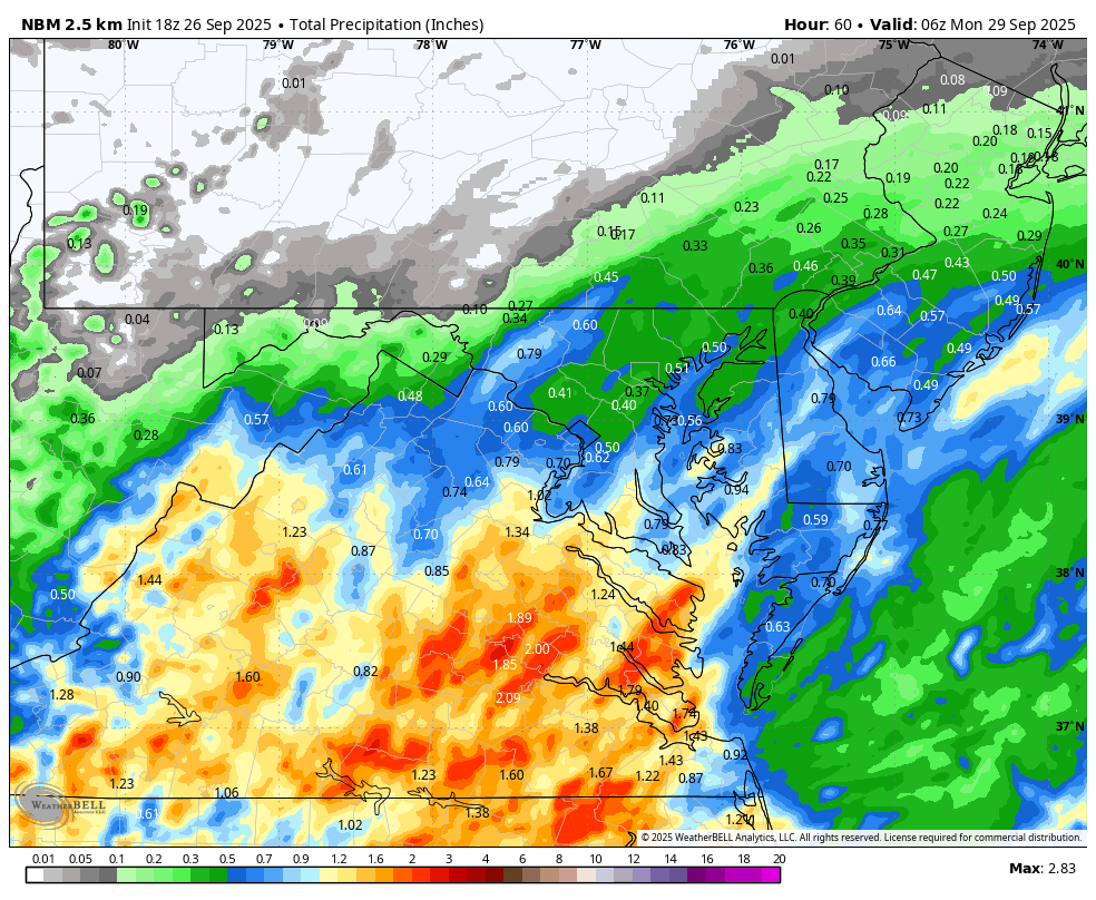
Busy doing yard work today, and it looks like I did not jinx the rain for later tomorrow! WB 18Z NBM for the weekend rain.
-
I have some maples near peak already. The Kanc/Lincoln will be funny Columbus day weekend with stick season well underway
-

September 2025 OBS-Discussion centered NYC subforum
lee59 replied to wdrag's topic in New York City Metro
That is a low record high, even for Westhampton. Meanwhile my high today was 81. - Today
-

September 2025 OBS-Discussion centered NYC subforum
donsutherland1 replied to wdrag's topic in New York City Metro
Newark has reached 86°. That's the fourth time it has reached 86° or above during the second half of September. The last time there were at least four such days during the second half of September was 2019 when there were five such days.


.thumb.jpeg.406ecda2eec9e267302c22b9f128fe3c.jpeg)