All Activity
- Past hour
-

Septorcher 2026 Discussion - Endless Summer
vortex95 replied to Damage In Tolland's topic in New England
What about something like this? G103mph at DE-lux-BURY MA (that's your nickname for the location, not mine!) https://en.wikipedia.org/wiki/October_2021_nor'easter| G113 mph Truro MA. That's among the highest gusts ev-A recorded at sea level in a nor'easter in New England. Probably the 2/2/1976 one had gusts this high on the ME coast (the one that flooded downtown BGR). And of course, @CoastalWx fav -- Dec 9, 2005 ("what's that roar noise outside?" -- said by Scott waking up in the aftn in GHG!). Even if we got something like this again, he'd be like, "MEH! NIMBY!" -
Update weenie dictionary https://www.patreon.com/JaysWintryMix/posts/97501273?utm_campaign=postshare_creator
-
Septorcher 2026 Discussion - Endless Summer
vortex95 replied to Damage In Tolland's topic in New England
Recall that overnight in Feb 2016 (I think it was that year)? @CoastalWx was thoroughly impressed w/ the LTG. Probably the most CGs in SNE for a single tstm event in Feb on record! Then he could not believe the two spinners in wrn MA on 2/25/2017! -
Septorcher 2026 Discussion - Endless Summer
vortex95 replied to Damage In Tolland's topic in New England
-
It eludes me why Emily from 2005 was not retired. Not b/c it was Cat 5 in July, but b/c it made two Cat 3 landfalls in Mexico. Usually, a Cat 3 or higher landfall anywhere us retired no problem. But retirement request I think are based on if the country(s) impact from officials there. Since Mexico was the only country direct impacted, they must have not requested it in the annual WMO meeting. Bret in 1999 was a Cat 3 landall in TX, but it was small and made landfall between the very sparsely populated area between CRP and BRO, so it was not retired.
-
These Ai models [emoji102]
- Today
-
2026 Atlantic Hurricane Season
vortex95 replied to Stormchaserchuck1's topic in Tropical Headquarters
A bit of caution here. The other two very strong El Ninos since 1950? 1983 was lowest ACE on record in the satellite era and only 4 NS. 1992 had only 7 NS and an ACE of 40. Yes, we had Andrew, but I am looking at entire seasons here, not individual storms. 1983 had Alicia Cat 3 that made a direct hit on HOU. 2023 going by the RONI index, was a moderate El Nino, not very strong. https://ggweather.com/enso/roni.htm This is only the 5th very strong El Nino since 1950, so small sample size precludes a statistically significant signal either way for what 2027 might hold using just very strong El Nino as an indicator. -
2026 Atlantic Hurricane Season
vortex95 replied to Stormchaserchuck1's topic in Tropical Headquarters
I think TCs result in 10-15% of rainfall overall in the tropics. Some areas much more. like Cabo San Lucas MX. Most sig rainfall here comes from TCs or their remnants. -
24-hr rain from last night (to 1200z) was 1.25" to 3.0" for Toledo. We had some more light showers. Now, SPC is considering a new severe thunderstorm watch for southern Michigan to NW Ohio late tonight
-
Is that considered a double-bounce?
-
K4MD - Baltimore/Pier 7 MD KBDQ - Morrilton AR KCHT - Chillicothe MO KK51 - Medicine Lodge KS KM46 - Colstrip MT PACE - Central AK PACI - Chalkyitsik AK METAR Site ID Change: K2V5 to KRYA - Wray CO
-

2026-2027 Record-breaking El Nino
ensonerd1233e343 replied to Stormchaserchuck1's topic in Weather Forecasting and Discussion
2023 was weird bc of weaker nino forcing due to warm global tropics -

E PA/NJ/DE Autumn 2026 Obs/Discussion
PhiEaglesfan712 replied to PhiEaglesfan712's topic in Philadelphia Region
1972-73 should be included as well. That was a -PDO, and was pretty much snowless at PHL. -
 reputable overseas online pharmacies: QuickPh :: top online pharmacy
 -

2026-2027 Record-breaking El Nino
raindancewx replied to Stormchaserchuck1's topic in Weather Forecasting and Discussion
Summer heat over the West looks like it has been destroyed, as Sept has been cold so far over some of the warmest areas, with more cooler than average temps coming for a while. Especially with significant rains likely from the dying East Pacific hurricane running north. Our local pattern of "every day is 90-105" has finally broken in Sept, which is nice. More rain forecast will help if it verifies. -
Might clean house...only up in the air in that scenario is Albernaz. Will depend on new GM unless Rubinstein wants him to stay, I suppose. What I have trouble believing is that Rubenstein does nothing. You can't publicly complain about being in last place and do nothing. And there is only one thing to do: fire Elias, clean house in the FO. He himself said that increasing payroll is not the end-all and there is more to successful ownership than that. I hope he takes what he learned from other top sports owners for his book, and applies to this organization.
-

Septorcher 2026 Discussion - Endless Summer
powderfreak replied to Damage In Tolland's topic in New England
Cold pool orographic showers led to rainbows as they moved through.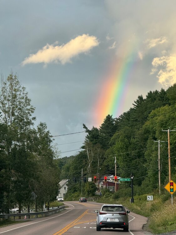
-
Long range 12z GFS was brutal for you all...
-
2026 Atlantic Hurricane Season
vortex95 replied to Stormchaserchuck1's topic in Tropical Headquarters
Yes, "the door swings both ways" as I always say. Sure, when you have high-end wx event that has big impacts, that is going to be front and center. However, there is flip side, when you get atypically inactive or quiet periods, or a pattern/cycles that suppresses extreme wx events. Heck, we've seen that over the decades for East Coast snowstorms, much to the dismay of snow weenies! I get it, out of sight, out of mind, and that does not sell, but that does not mean it is not important or should be ignored from scientific or meteorological POV. The reporting bias of wx from the MSM and social media is obvious. and that skews perception. What suppresses TC activity, or any stormy wx, is just as important as what favors it. There should be more study on this. TC are more tenuous as to existing than many think. They require very specific conditions to develop and maintain. and SSTs alone do not cut it (far too much emphasis on those IMHO). What matters most is in the atmosphere, not the ocean. Wind shear and TPW are paramount. You can have all the warm water in the world, but if the atmosphere does not cooperate, you get nothing or TCs that have trouble getting intense. This Atlantic season so far displays it more obvious than I think any other recently. High shear across the MDR?, no dice. And what manages to develop, struggles big time and does not last long. And look at Edouard. Over 31 C SSTs, and it still took its time developing b/c of a lot of dry air present and minor shear. Close to landfall, it got closer to the center of a 250 mb high pressure, and only *then* did it make its move, so to speak. The shear decreased to near zero, and less shear stopped the entrainment of dry air into the core. Edouard being so small, it makes a TC more vulnerable to even small environmental changes, and drier synoptic environment typically means TCs will be smaller overall. So you see how it is all tied together. You can't treat any wx parameter in a vacuum. The ocean and the atmosphere are coupled. -
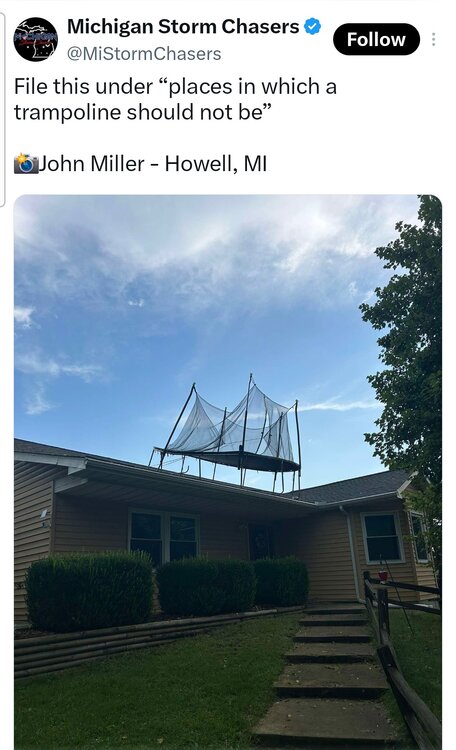
This you @Jonger?
-
Not gonna bother changing the snow blower's oil this fall.
-

2026 Atlantic Hurricane Season
WxWatcher007 replied to Stormchaserchuck1's topic in Tropical Headquarters
The AMO is SO important. People really do forget how the Atlantic can vary for decades at a time! Doesn’t mean we can’t get a big event during a “lull” but of all the areas where you really need to care about the longer historical record, tropical is it. I’ll also just note, this is an extremely impressive season so far—it just happens to be on the other side of the activity spectrum. To have this little ACE, this deep into the general climatological peak in the Atlantic, it’s really something to behold. -
.thumb.jpg.6a4895b2a43f87359e4e7d04a6fa0d14.jpg)
Central PA Summer 2026 Discussion/Obs Thread
Yardstickgozinya replied to Voyager's topic in Upstate New York/Pennsylvania
I believe it might have been confirmed this afternoon. -
2026 Atlantic Hurricane Season
vortex95 replied to Stormchaserchuck1's topic in Tropical Headquarters
Ginger in 1971 is one of the oddest TC tracks and second-long lasting TC in the Atlantic on record. https://en.wikipedia.org/wiki/Hurricane_Ginger The "Yankee" hurricane in 1935 started near Bermuda and ended up hitting MIA from the ENE! https://en.wikipedia.org/wiki/1935_Yankee_hurricane For the oddest track globally?, Typhoon Wayne in the NW Pacific in 1986 takes the cake here! https://en.wikipedia.org/wiki/Typhoon_Wayne_(1986) -
Nailed this one tonight: