NaoPos Posted June 10, 2013 Share Posted June 10, 2013 well, new update from the SPC puts a decent chunk of southern/se pa in the slight risk: EDIT* updated 12z SPC WRF @ 23z Link to comment Share on other sites More sharing options...
DiehardFF Posted June 10, 2013 Share Posted June 10, 2013 Hey guys, any threat of severe wx for Bucks County today? I haven't had a chance to look into this. Link to comment Share on other sites More sharing options...
NaoPos Posted June 10, 2013 Share Posted June 10, 2013 Hey guys, any threat of severe wx for Bucks County today? I haven't had a chance to look into this. check out the SPC outlooks i posted above. Link to comment Share on other sites More sharing options...
HM Posted June 10, 2013 Share Posted June 10, 2013 The latest obs in DE / Chesapeake area are looking good. 12z SPC WRF max UH really looks good for E MD ~ 22z which moves eastward into DE before diminishing. It is quite possible the urban corridor VA-MD to DE sees a few tornadoes this afternoon. It is exceptionally moist out there and we are about to see an increase in the low-mid level winds with a warm front near by.... Link to comment Share on other sites More sharing options...
NaoPos Posted June 10, 2013 Share Posted June 10, 2013 well, PHL is stuck with E winds, DOver basking in SE winds....... i think unless the WF pushes N somehow, its stuck between the aforementioned points. Link to comment Share on other sites More sharing options...
Thunder Road Posted June 10, 2013 Share Posted June 10, 2013 Never fails. I go out chasing in the Plains and we've got a 5% TOR at home. Looks like it could be a surprise set-up in MD and VA. Link to comment Share on other sites More sharing options...
HM Posted June 10, 2013 Share Posted June 10, 2013 well, PHL is stuck with E winds, DOver basking in SE winds....... i think unless the WF pushes N somehow, its stuck between the aforementioned points. In this case, it is possible theta-e advection/warm front surge could be sufficient to sustain supercells (sunshine not a big deal near the warm front). But, yeah it really hasn't budged as new areas of rain/convection helped to cool the "cool sector" even more. Watch in the next couple of hours which is when the models starting showing the advancement north. It seems like the DE-MD is the main show with adjacent S PA/NJ. Link to comment Share on other sites More sharing options...
NaoPos Posted June 10, 2013 Share Posted June 10, 2013 In this case, it is possible theta-e advection/warm front surge could be sufficient to sustain supercells (sunshine not a big deal near the warm front). But, yeah it really hasn't budged as new areas of rain/convection helped to cool the "cool sector" even more. Watch in the next couple of hours which is when the models starting showing the advancement north. It seems like the DE-MD is the main show with adjacent S PA/NJ. pshh, you should see the trolling texts im getting from tombo- "i love east winds", "heavy rains are good" hahaha. We'll see though. Best chance is still down to DC area.Also, seeing the reflectivity going from reds to orange within the same corridor the last few hours makes me think that the WF might not be advancing that far North the rest of the day. Link to comment Share on other sites More sharing options...
IsentropicLift Posted June 10, 2013 Share Posted June 10, 2013 Tornado watch hoisted till 10PM Link to comment Share on other sites More sharing options...
NaoPos Posted June 10, 2013 Share Posted June 10, 2013 Tornado watch hoisted till 10PM http://www.spc.noaa.gov/products/watch/ww0293.html Link to comment Share on other sites More sharing options...
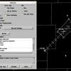
Quincy Posted June 10, 2013 Share Posted June 10, 2013 Here's the Watch graphic: Link to comment Share on other sites More sharing options...
NaoPos Posted June 10, 2013 Share Posted June 10, 2013 Probability of 2 or more tornadoes Mod (60%) Probability of 1 or more strong (F2-F5) tornadoes Low (20%) Wind Probability of 10 or more severe wind events High (80%) Probability of 1 or more wind events > 65 knots Low (<5%) Hail Probability of 10 or more severe hail events Low (10%) Probability of 1 or more hailstones > 2 inches Low (<5%) Combined Severe Hail/Wind Probability of 6 or more combined severe hail/wind events High (>95%) Link to comment Share on other sites More sharing options...
HM Posted June 10, 2013 Share Posted June 10, 2013 The degree of moisture near/south of the warm front will be enough (in combination with lift/shear) for a tornado. Our main potential is probably with this first line / round associated with a weak vort max, on the edge of an approaching LLJ. If a second area gets going behind this over VA/MD, it would come much later in the day and likely not pose a threat here for tornadoes. Today is all about advecting...not getting the sun to come out (unless you are far enough south of the warm front). Link to comment Share on other sites More sharing options...
MGorse Posted June 10, 2013 Share Posted June 10, 2013 Never fails. I go out chasing in the Plains and we've got a 5% TOR at home. Looks like it could be a surprise set-up in MD and VA. Surprise set up? Link to comment Share on other sites More sharing options...
greg ralls Posted June 10, 2013 Share Posted June 10, 2013 Possibly an interesting cell about to move from Delaware into Pennsylvania right now? Edit: Nevermind, doesn't look very good now. Link to comment Share on other sites More sharing options...
bluehens Posted June 10, 2013 Share Posted June 10, 2013 Possibly an interesting cell about to move from Delaware into Pennsylvania right now? Just heavy heavy rain in that cell but no thunder or lightening. Link to comment Share on other sites More sharing options...
greg ralls Posted June 10, 2013 Share Posted June 10, 2013 Just heavy heavy rain in that cell but no thunder or lightening. Yeah, I edited my post to reflect that it didn't look so good...probably just as you were replying. Link to comment Share on other sites More sharing options...
NaoPos Posted June 10, 2013 Share Posted June 10, 2013 interesting looking feature: Link to comment Share on other sites More sharing options...
DiehardFF Posted June 10, 2013 Share Posted June 10, 2013 Looks like Bucks is just out of the watch. Very cloudy here aswell. Link to comment Share on other sites More sharing options...
Quakertown needs snow Posted June 10, 2013 Share Posted June 10, 2013 the one at norristown heading towards my work location, building a little Link to comment Share on other sites More sharing options...
greg ralls Posted June 10, 2013 Share Posted June 10, 2013 the one at norristown heading towards my work location, building a little Dumped some very heavy rain here in King of Prussia. Link to comment Share on other sites More sharing options...
NJHurricane Posted June 10, 2013 Share Posted June 10, 2013 Sun coming close to poking out through otherwise mostly cloudy skies here in National Park NJ....even just 20 minutes of sun is gonna make it real steamy Link to comment Share on other sites More sharing options...
Quakertown needs snow Posted June 10, 2013 Share Posted June 10, 2013 Dumped some very heavy rain here in King of Prussia. dumping here at work, lansdale area lots of mini rivers. Link to comment Share on other sites More sharing options...
iceman56 Posted June 10, 2013 Share Posted June 10, 2013 the one at norristown heading towards my work location, building a little Looks like B5 and Y7 have a bead on my garden just in case there are any plants not already drowned... Link to comment Share on other sites More sharing options...
Quakertown needs snow Posted June 10, 2013 Share Posted June 10, 2013 tornado warning sw Link to comment Share on other sites More sharing options...
Harbourton Posted June 10, 2013 Share Posted June 10, 2013 14 degree difference between Lakehurst Naval Air Station and Mercer County Airport. Wind is still east here at 69 degrees. Link to comment Share on other sites More sharing options...
greg ralls Posted June 10, 2013 Share Posted June 10, 2013 Wow, look at all of this stuff coming from the southwest. My commute from KoP to Collegeville gets underway in about an hour, and I'm already thinking of just heading to Rock Bottom in the King of Prussia Mall or something to delay my departure. Link to comment Share on other sites More sharing options...
Quakertown needs snow Posted June 10, 2013 Share Posted June 10, 2013 more hits/downpours pending Link to comment Share on other sites More sharing options...
MGorse Posted June 10, 2013 Share Posted June 10, 2013 14 degree difference between Lakehurst Naval Air Station and Mercer County Airport. Wind is still east here at 69 degrees. The temperature reading at Lakehurst (KNEL) is incorrect. There was a thread about it before. Link to comment Share on other sites More sharing options...
SouthernNJ Posted June 10, 2013 Author Share Posted June 10, 2013 PHL TDWR picking up some rotation near Gap and Atglen at the Chesco/Lanco border. Link to comment Share on other sites More sharing options...

Recommended Posts
Archived
This topic is now archived and is closed to further replies.