SouthernNJ Posted May 11, 2013 Share Posted May 11, 2013 This is for discussion or observation of convective elements moving through the area. Not many events so far this year. Perhaps a few stronger storms today. Link to comment Share on other sites More sharing options...
SouthernNJ Posted May 11, 2013 Author Share Posted May 11, 2013 A few strong storms crossed North Central Jersey, and now an intense storm is near Williamstown and Sicklerville, producing a lot of lightning. Link to comment Share on other sites More sharing options...
SouthernNJ Posted May 11, 2013 Author Share Posted May 11, 2013 A storm with a supercell structure was about 15 miles SW of Toms River...moving toward Lacey and Bayville. Looks nice for this neck of the woods. Link to comment Share on other sites More sharing options...
SmokeEater Posted May 11, 2013 Share Posted May 11, 2013 Pretty good size power outage in Franklin Twp. from that storm that moved through Williamstown, along with a few wires calls in Monroe Twp. I had just gotten back to the firehouse from a Disaster Drill at ACY, so I couldn't go after it, even though it was 5 miles away, lol. Link to comment Share on other sites More sharing options...
Absolute Humidity Posted May 11, 2013 Share Posted May 11, 2013 1.15 in the bucket so far. Lots of downpours with thunder and lightning with no wind at all. Link to comment Share on other sites More sharing options...
NaoPos Posted May 11, 2013 Share Posted May 11, 2013 Damn river killed off these storms approaching delco Link to comment Share on other sites More sharing options...
SmokeEater Posted May 11, 2013 Share Posted May 11, 2013 More cells incoming down here, they keep forming around BWI, pushing east. Link to comment Share on other sites More sharing options...
SmokeEater Posted May 11, 2013 Share Posted May 11, 2013 Cell coming out of Buena. Link to comment Share on other sites More sharing options...
SmokeEater Posted May 11, 2013 Share Posted May 11, 2013 Here's one from earlier, down at our drill at ACY, when one of the many drenching storms moved in. Link to comment Share on other sites More sharing options...
greg ralls Posted May 11, 2013 Share Posted May 11, 2013 Double rainbow over Collegeville at 7 PM. Link to comment Share on other sites More sharing options...
tombo82685 Posted May 12, 2013 Share Posted May 12, 2013 i took this thursday, a little late but a nice picture Link to comment Share on other sites More sharing options...
Quakertown needs snow Posted May 12, 2013 Share Posted May 12, 2013 no power since 6:45pm Link to comment Share on other sites More sharing options...
hockeyinc Posted May 12, 2013 Share Posted May 12, 2013 Here's one from earlier, down at our drill at ACY, when one of the many drenching storms moved in.ImageUploadedByTapatalk 21368314266.952783.jpg Smoke.... Where was the drill at???? The old Bader Field, or the airport outside of town??? Link to comment Share on other sites More sharing options...
SmokeEater Posted May 12, 2013 Share Posted May 12, 2013 Here's one from earlier, down at our drill at ACY, when one of the many drenching storms moved in.ImageUploadedByTapatalk 21368314266.952783.jpg Smoke.... Where was the drill at???? The old Bader Field, or the airport outside of town??? Actually at AC International in EHT. Simulated plane crash with 200 patients/victims. Was bad enough I got ridiculously drenched on the tarmac in full gear and a pack for 2 1/2 hours, I felt really bad for the 100 or so people playing victims, lol. Link to comment Share on other sites More sharing options...
SmokeEater Posted May 14, 2013 Share Posted May 14, 2013 See text for tomorrow for most of the area. ...UPPER OH VALLEY/DELMARVA... WEAK MID LEVEL HEIGHT FALLS WILL SPREAD ACROSS SERN CANADA/GREAT LAKES REGION INTO THE UPPER OH VALLEY LATE IN THE PERIOD. WHILE ASSOCIATED SFC LOW/LARGE SCALE FORCING WILL SPREAD WELL NORTH OF THE CNTRL APPALACHIANS/DELMARVA...TRAILING FRONTAL ZONE WILL ADVANCE TO A POSITION FROM SYR TO PIT BY 16/00Z WITH N-S WARM FRONT EXPECTED TO ORIENT ITSELF ACROSS THE HUDSON VALLEY DURING THE LATE AFTERNOON. VEERED WLY FLOW WITHIN THE WARM SECTOR SHOULD ALLOW A BIT MORE MOISTURE TO ADVANCE ACROSS THE OH VALLEY INTO THIS REGION BUT REMAIN CONSIDERABLY DRIER THAN SEVERAL 12Z MODELS SUGGEST...LIKELY RISING ONLY INTO THE 50S. AFTERNOON HEATING SHOULD CONTRIBUTE TO DESTABILIZATION ACROSS PA SUCH THAT ISOLATED THUNDERSTORMS COULD DEVELOP AHEAD OF THE COLD FRONT. CONVECTION THAT EVOLVE ACROSS THIS REGION WOULD SPREAD SEWD TOWARD THE DELMARVA WITHIN STRONGLY SHEARED BUT WEAKLY UNSTABLE ENVIRONMENT. FOR THIS REASON IT APPEARS 5 PERCENT SEVERE PROBS FOR LOCALLY STRONG WINDS WILL SUFFICE ACROSS MUCH OF PA INTO THE DELMARVA. Link to comment Share on other sites More sharing options...
NaoPos Posted May 14, 2013 Share Posted May 14, 2013 low cape, high shear environment? Could be worse i suppose. Pretty nasty cap in place tomorrow as well. I'd be surprised if we didnt see a slight risk tomorrow for the area. Link to comment Share on other sites More sharing options...
NaoPos Posted May 14, 2013 Share Posted May 14, 2013 PS= Nam is probably overdone with instability. IF not, its something to keep an eye on tomorrow. Link to comment Share on other sites More sharing options...
Thunder Road Posted May 15, 2013 Share Posted May 15, 2013 PS= Nam is probably overdone with instability. IF not, its something to keep an eye on tomorrow. I've been on the road all day and so I haven't looked at anything yet, but those are same damn good parameters for our side of the Appalachians. (You'd be surprised how many tornado days - regardless of area of the U.S. - are low CAPE/high shear days.) Link to comment Share on other sites More sharing options...
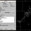
Thunder Road Posted May 15, 2013 Share Posted May 15, 2013 Earl Barker's model Skew-T page calculates a lot of indices for you: But the site's GUI is god awful, so I've red-boxed some of the more useful parameters. They're actually quite good for our area. (0-3 km CAPE of 25.0 J/kg is probably more or less just "average," but whatever.) Wind field would support eastward-propagating clusters/line segments (quickly though, ~35 kts) that would be probably be hail-producers. There isn't *quite* enough turning for supercells, imo, but it's close. Two problems though: One is that it's the NAM, so all of those parameters (or at the very least, the thermodynamic ones) are likely overdone. Second is that there's no forcing. It appears that there's a surface pressure trough down the East Coast not associated with any temp/moisture gradient, and some sort of frontal boundary stretching from the Low in Canada westward across OH, IN, and IL. And of course there's the warm front, which the NAM has pushing through KPHL 21z-00z, along with the associated frontal inversion. But within the warm sector itself, there's not much going on, which is why you see the NAM composite reflectivity showing a whole lotta nothing. (The warm sector is actually not capped, or at least, not with an unbreakable cap. The lack of convection really is just due to the lack of forcing, imo.) Maybe there'll be one random storm that be a 3/22/1955 redux, haha. Link to comment Share on other sites More sharing options...
NaoPos Posted May 31, 2013 Share Posted May 31, 2013 Day 3 slight risk: SPC AC 310756 DAY 3 CONVECTIVE OUTLOOK CORR 1 NWS STORM PREDICTION CENTER NORMAN OK 0256 AM CDT FRI MAY 31 2013 VALID 021200Z - 031200Z ...THERE IS A SLGT RISK OF SVR TSTMS ACROSS THE NORTHEAST/MID-ATLANTIC STATES AND NEW ENGLAND... ...THERE IS A SLGT RISK OF SVR TSTMS ACROSS SOUTHWEST TX/SOUTHEAST NM... CORRECTED FOR GENERAL TSTM AREA ...NORTHEAST/MID-ATLANTIC STATES AND NEW ENGLAND... A MID/HIGH LEVEL SPEED MAX IS EXPECTED TO SHIFT NORTHEASTWARD OVER THE NORTHEAST STATES/NEW ENGLAND ON THE PERIPHERY OF AN UPPER TROUGH PIVOTING OVER ONTARIO/QUEBEC AND THE GREAT LAKES REGION. WHILE SHOWERS/SOME TSTMS MAY ACCOMPANY THE COLD FRONT EARLY SUNDAY...POCKETS OF STRONGER DESTABILIZATION ARE PROBABLE AHEAD OF THE FRONT...ALTHOUGH WEAK MID-LEVEL LAPSE RATES MAY TEMPER THE OVERALL DEGREE OF DESTABILIZATION. EVEN SO...MLCAPE ON THE ORDER OF 1000 J/KG OR GREATER WILL BE SUFFICIENT FOR STRONG/SEVERE TSTM DEVELOPMENT AND INTENSIFICATION INTO THE AFTERNOON. AS STORMS MATURE...STRONG DEEP LAYER SOUTHWESTERLY WINDS...ACCENTUATED BY AS MUCH AS 35-50 KT BETWEEN 2-6 KM...WILL SUPPORT THE DEVELOPMENT OF ORGANIZED/SUSTAINED CLUSTERS OF STORMS INCLUDING BOWS. DAMAGING WINDS WILL BE THE PRIMARY HAZARD...ALTHOUGH SOME SEVERE HAIL/PERHAPS A TORNADO THREAT MAY EXIST AS WELL. ... ..GUYER.. 05/31/2013 Link to comment Share on other sites More sharing options...
NaoPos Posted May 31, 2013 Share Posted May 31, 2013 Something going against us is timing. The better forcing doest arrive till 0z-9z Sunday night Into Monday am. In sure there will be some chances with a lee side trough, but the timing with this screams "N&W" of the city for best chances of severe. Link to comment Share on other sites More sharing options...
phlwx Posted June 1, 2013 Share Posted June 1, 2013 Day 2 slight, 30% ABE-RDG-LNS, N & W of there. 15% in the city Link to comment Share on other sites More sharing options...
NaoPos Posted June 1, 2013 Share Posted June 1, 2013 Fwiw, Nam brings in some showers and storms later today. Garden variety at best.. Around 0z timeframe . Link to comment Share on other sites More sharing options...
NaoPos Posted June 1, 2013 Share Posted June 1, 2013 Nice little thunderhead going up looking North from the stadium Link to comment Share on other sites More sharing options...
NJHurricane Posted June 1, 2013 Share Posted June 1, 2013 Couple rounds of fun on the latest hi-res NAM Link to comment Share on other sites More sharing options...
phlwx Posted June 1, 2013 Share Posted June 1, 2013 If the NAM (either hi res or op) is right, tomorrow after 4 PM looks like it'll be pretty stormy. Link to comment Share on other sites More sharing options...
Thunder Road Posted June 2, 2013 Share Posted June 2, 2013 Carnage for all of I-95 from NYC to WAS at 22z on tonight's SPC WRF: The NSSL WRF, not shown, is significantly less impressive, but it also has the idea of multiple lines tomorrow evening (although most are broken/scattered, and on this particular run Philly and immediate burbs miss out). Link to comment Share on other sites More sharing options...
phlwx Posted June 2, 2013 Share Posted June 2, 2013 30% wind 95 N/W, 15% hail. Slight risk generally N/W of NJ Turnpike. NAM hi res is generally after 5 PM in the city, earlier west, with threat. Link to comment Share on other sites More sharing options...
Thunder Road Posted June 2, 2013 Share Posted June 2, 2013 15% for Wind and Hail was pulled all the way to the coast, but the 30% Wind was cut off north of NYC with the 1630. Discussion didn't specifically mention why the 30% was pulled back, but it seems that more cloud cover down here limiting instability was what prompted them to do it. Link to comment Share on other sites More sharing options...
NaoPos Posted June 2, 2013 Share Posted June 2, 2013 New outlook. 30% wind jumped N&W, 15% wind and hail chances...not expecting much other than garden variety. Link to comment Share on other sites More sharing options...

Recommended Posts
Archived
This topic is now archived and is closed to further replies.