TellicoWx
-
Posts
2,632 -
Joined
-
Last visited
Content Type
Profiles
Blogs
Forums
American Weather
Media Demo
Store
Gallery
Everything posted by TellicoWx
-
Virga Monster has been winning the battle here..still dont have the first flake/pellet lol
-
Reports of all bridges on Hwy 72 heading east out of Huntsville, AL have iced over
- 618 replies
-
- 2
-

-

-
- observations
- obs thread
- (and 1 more)
-
Noticed that...with the early arrival would think that cuts totals (but how can base anything off modeling with CAMs this far off except RAP lol). Was suppose to get a break in precip, but line looks pretty continous across southern border
-
Apparently not Virga, if so way ahead of schedule
-
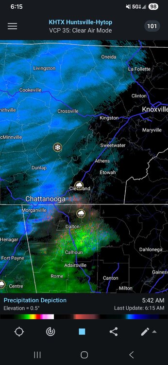
Reports of sleet in Cleveland
-
And some of the pieces that normally protect my area gets weakened or taken away.
-
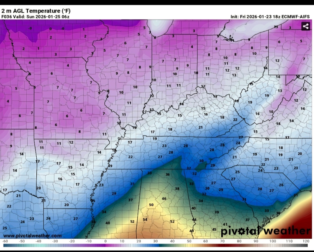
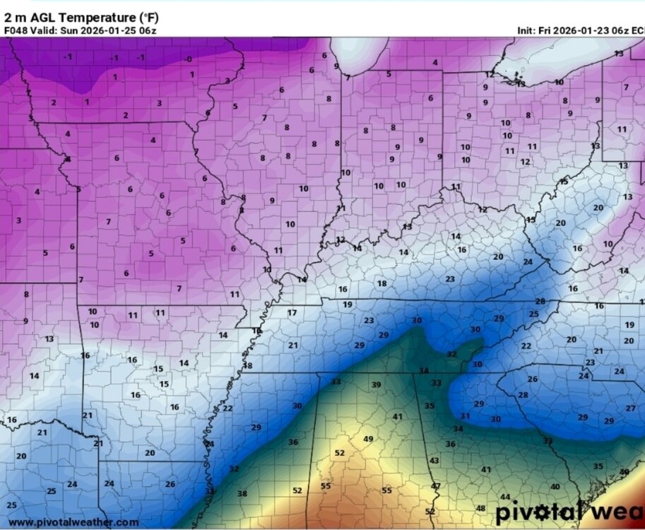
18z Euro AI vs 6z Euro Ai at same timeframe...definitely trending toward the HP tongue wrapping around the southern end of valley

-
I've went from .1" before hitting freezing at 6z to .5" on the 18z...Euro AI Edit..QPF total
-
Not sure if it was mentioned at 12z, but looping 18z Euro AI at hr 36..it is now slower bringing my area above freezing
-
@nrgjeffnot at all saying it's wrong for Chatty btw, just it doesn't make sense here for the foothill/mtn.
-
The earlier chart made more sense as far as here in Monroe Co...New one upped the totals for Tellico and the Skyway which would be almost unheard of if it happened. If it was a model output, it would honestly go in the trash bin here.
-
@Scottie16 A typical front takes 45 mins to an hour to make the trip from Sweetwater to Tellico
-
If you wanna watch in real time...use Wunderground PWS site. I can but I'm at work. Some of the stations update every 10 seconds, it's what I use for real time obs
-
Lol...shows how often I read them
-
MRX not do an AFD around 4pm today? Noticed ice cumulation map changed
-
The 2015 ice storm at one point the RGEM was only one that showed the threat. That storm was when I started following it with the other runs
-
Lol...accidentally hit the wrong time hour looking on this current setup and about fell out of my chair....then realized it wasn't a certain year in the 1990's
-
On lunch, but looked back at old photos. Took a pic of my little girl in Madisonville with trees down behind her and everything coated in about .25" of ice...timestamp says Feb 18, 2015. This setup has been reminding me of it for several days. Large part of county lost power for almost a week. It really stands out now, due to same wording was used then, as MRX is using now for Monroe Co. (We were excluded then from Ice Storm Warning and alot of residents let their guard down). There is a ridge between Tellico and Madisonville that seems to bank the downslope winds back toward Tellico...prolongs the cold air retreat NW of there. Forecast all the way until the event started was WWA (less than 0.10"). CAMs resolution doesn't pick this ridge up well...I know of their current projection map, they seem to have forgot this. Hopefully I'm wrong.
-
I can tell you 100%.... Any global that shows ice up on the Skyway, the resolution isn't good enough. Any CAMs that show ice the placement of the resolution is off.
-
Takes a thousand puzzle pieces to come together to get an ice storm in the valley (esp. Southern valley)
-
Honestly think should have used the nw zone of Monroe Co for ice storm warning
-
For east tn folks, this setup is where know your climo plays the biggest. Like I know that Tellico has realistically less than a 10% chance of significant icing (just way where situated), I know if I drive 5 mins up 68 into the Notchey Creek/Mt Vernon area their risk grows substantially (past history of power going out there in ice setups)
-
Really need these HiRes CAMs to get in range. While Globals are great at overall setup over the valley, their resolution is just not sharp enough during ice setups due to the million microclimates in the valley. While the QPF output on the hrrr may not be close to accurate, can definitely get more detailed view of where the cold is being trapped.
-
Memphis went from 0.5" snow on 6z vs 6" snow on 12z hrrr
-
Know HRRR is still outside it's range, but each run keeps slowly inching the snow line a little south each run