TellicoWx
-
Posts
2,632 -
Joined
-
Last visited
Content Type
Profiles
Blogs
Forums
American Weather
Media Demo
Store
Gallery
Everything posted by TellicoWx
-
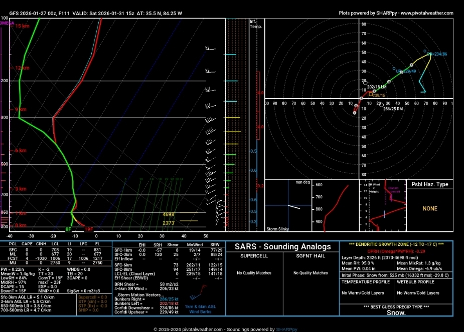
Decent analog...globals struggle with deep cold and low levels being saturated
-
I agree..vort is 50-100 miles east of where CMC has it most the eastern Valley loses the lift needed. The surface low off the coast only offers maybe some better moisture transport to the 850. Think we are 100% dependent on the 850...surface LP is just too far off (unless the whole setup can go negative tilt and phase together sooner)
-
We saw the effect of trapped moisture with just enough lift last night and this morning..now place that DGZ near the surface and instead of mist you get nickles and dimes
-
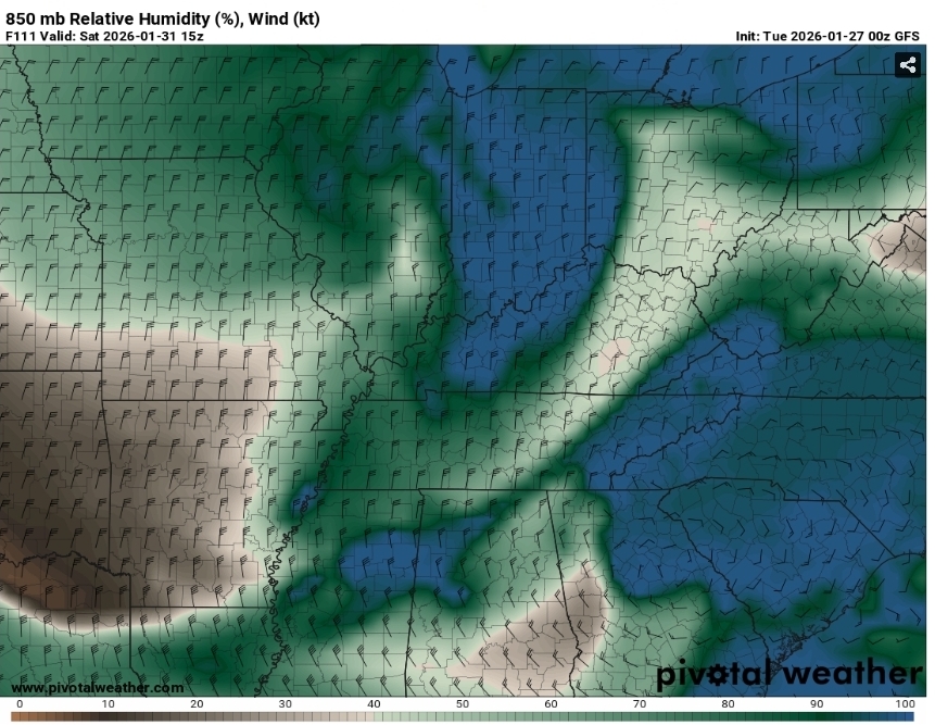
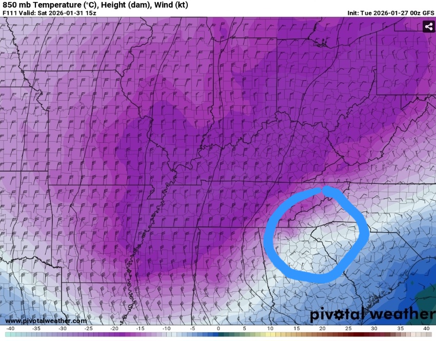
Take where the 850 vort is placed on the GFS and overlay that onto the CMC snowfall map...you can see the where the forcing is breaking out the snowfall.
-
GFS joined the others somewhat on the general placement of the 850 vort (circled in blue)...lift=somewhat of a check. DGZ near the ground=check (mountains aiding in the lift). 850 saturated and trapped in valley=check. Any minor change in that 850 vort placement will light fuse so to speak for the GFS (was really close). Now just hold those ingredients for next 4 days lol. The approach of the center of the lobe of cold air alot will also help enhance the lift by squeezing everything out.
-
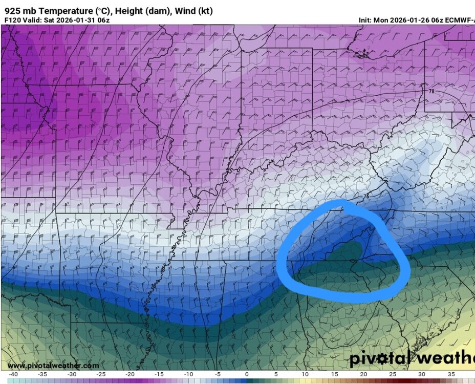
One thing to note is the DGZ is going to be very close to the surface. The difference in solutions run to run is dependent upon where the 850 vort passes when dropping south out of Canada. If the winds veer at 850 from the NW instead of N, NNE then the lift mechanism needed would be the mountains/plateau. Moisture is in place, just need something to lift the parcels.
-
So you're telling me there's a chance lol
-
Would make sense...it and Euro AI typically run neck and neck from the limited verification scores
-
And that's where the AI adaptation comes in to play...AI enhanced systems can add those pieces of the equation back in without consuming large amounts of computing power compared to the traditional system
-
I've tried to figure that problem out for years...personally, I think it has to doe with the grids and physics engines for the upper air pattern. The closer you get alot of times the 500 pattern slowly ticks west..like the physics engine is too fast advancing leads to the old saying "models keep kicking the can down the road" in the LR. When they got rid of truncation and went physics based, they had to figure out a way to not consume enormous amounts of energy to run the system...so as the models advance in time, they generalize and remove some of the physics equation involved which leads models being to quick in upper air pattern. Just theory been working on.
-
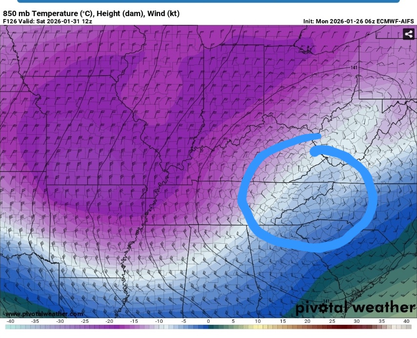
850/925 vort circled of the 6z Euro Ai...this is the big puzzle pieces to me
-
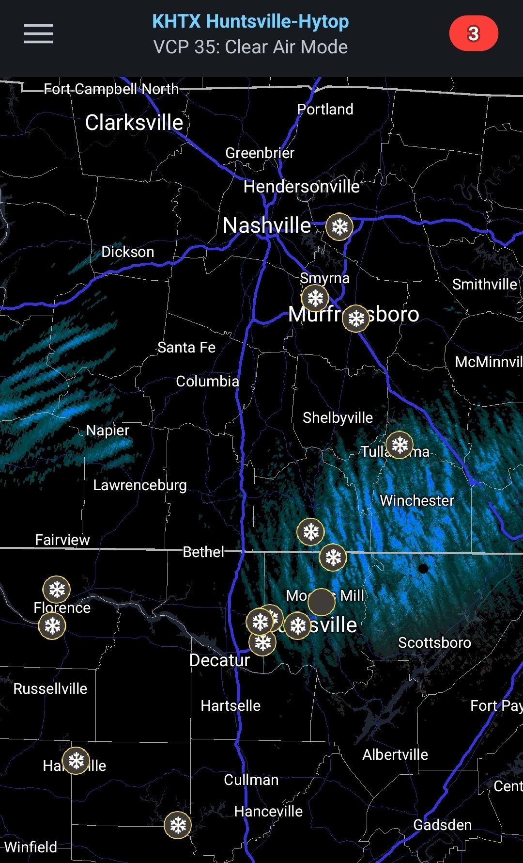
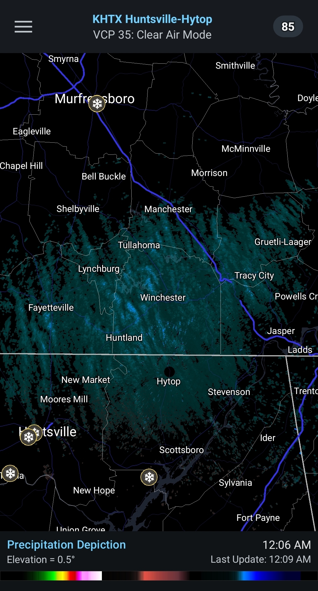
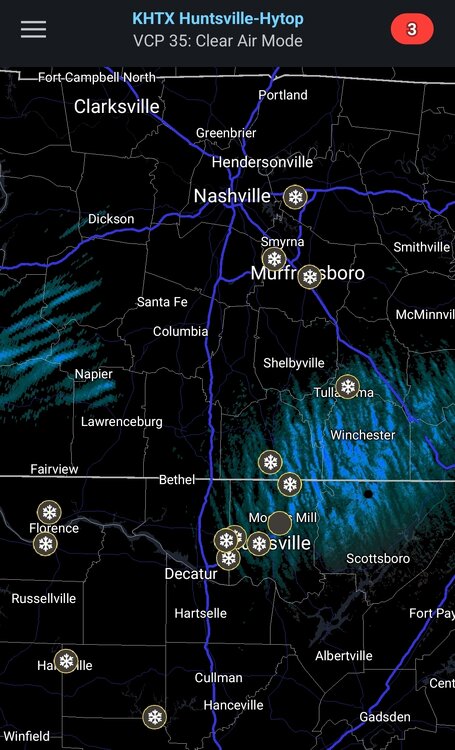
Ummm...what is HUN radar picking up. Snow streaks to west are moving sw to NE...ones at radar are moving NNW to SSE...
- 618 replies
-
- 4
-

-
- observations
- obs thread
- (and 1 more)
-
Definitely freezing drizzle..trees starting to get that glistening look to them
- 618 replies
-
- 1
-
-
- observations
- obs thread
- (and 1 more)
-
Shhh...dont wanna scare it away this time lol
-
Know plateau can sometimes dry things out on this side, but HUN radar seems to be "thickening up" in the lower atmospher

- 618 replies
-
- 2
-
-
- observations
- obs thread
- (and 1 more)
-
Just checked deck and elevated surfaces turning to slush..31.7. Heavy drizzle/micro snowflakes/mist..not sure what to call it lol
-
Glad you atleast got power back
-
Picked up almost quarter inch (.23) since 630 under no radar returns
- 618 replies
-
- 1
-
-
- observations
- obs thread
- (and 1 more)
-
Not sure to call it heavy drizzle or light rain here...its still going.
- 618 replies
-
- 2
-
-
- observations
- obs thread
- (and 1 more)
-
HUN has now put out a WWA for their area until 1 am
- 618 replies
-
- 3
-
-
- observations
- obs thread
- (and 1 more)
-
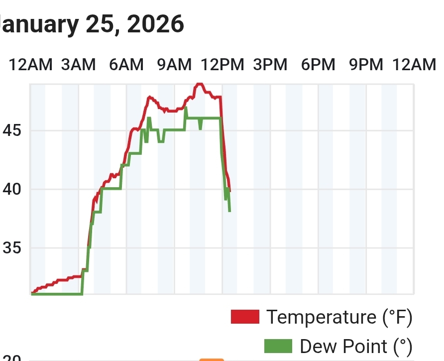
Been almost constant light rain here for last couple hours (no radar returns). If it had been this consistent last night icing would have been bad. Cold front moved thru about 30 mins ago, temp dropping quickly now.
- 618 replies
-
- 5
-
-
- observations
- obs thread
- (and 1 more)
-
Light drizzle/mist here currently..not good for area roads tonight
- 618 replies
-
- 1
-

-
- observations
- obs thread
- (and 1 more)
-
Temp starting to crash on the mountain..bye bye 50's.
- 618 replies
-
- 1
-
-
- observations
- obs thread
- (and 1 more)
-
Yeah, not as drastic but Tellico was 51 when I left for work, Madisonville was 33 when I got there.
- 618 replies
-
- 2
-
-
- observations
- obs thread
- (and 1 more)