TellicoWx
-
Posts
2,632 -
Joined
-
Last visited
Content Type
Profiles
Blogs
Forums
American Weather
Media Demo
Store
Gallery
Everything posted by TellicoWx
-
March 11th-13th Winter Weather Event. Winter's last gasp?
TellicoWx replied to Windspeed's topic in Tennessee Valley
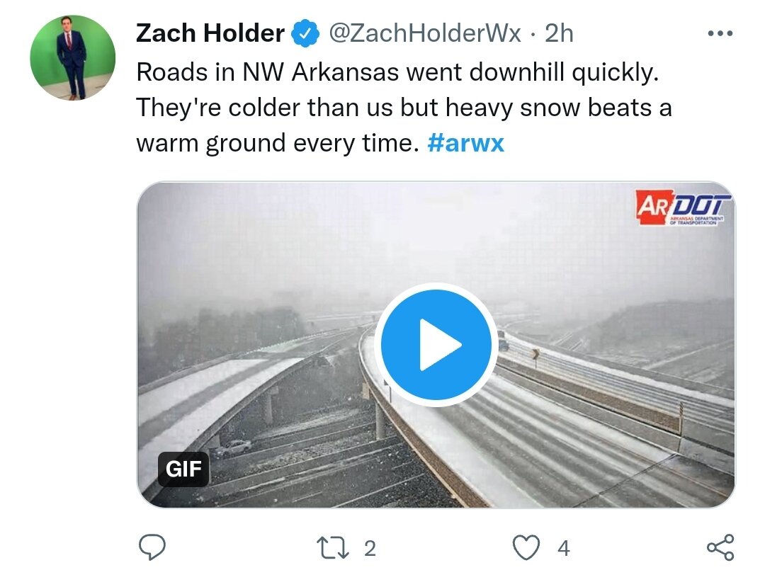
I49 in NW AR is being closed...6z GFS/HRRR seem to have had the best handle there for what it's worth. Nam 3k did very poorly. Understatement of the year for those folks..alot of wrecks reported. Was near 70 yesterday.
-
January 28th-29th Clippers/NW Flow Obs/Last Minute Forecasts.
TellicoWx replied to John1122's topic in Tennessee Valley
Ended up getting about a 10 min shower..got a dusting in the grass. Thats actually decent for this type system. -
January 28th-29th Clippers/NW Flow Obs/Last Minute Forecasts.
TellicoWx replied to John1122's topic in Tennessee Valley
Up on Skyway and Coker Creek do ok in these, town very rarely scores -
January 28th-29th Clippers/NW Flow Obs/Last Minute Forecasts.
TellicoWx replied to John1122's topic in Tennessee Valley
I'm at home in Tellico..not even a flurry lol. Sweetwater is snowing...snow on sides of the road and parking lots are white. -
January 28th-29th Clippers/NW Flow Obs/Last Minute Forecasts.
TellicoWx replied to John1122's topic in Tennessee Valley
Lol, I can't even buy a flake today -
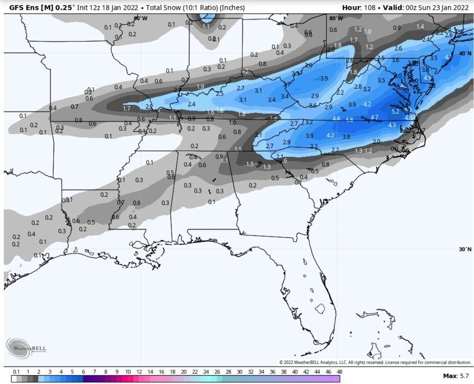
12z CMC pops a low (day later) that is on a similar track as the GFS.
-
So far all 0z modeling looking a little better (NAM, RGEM, ICON) for NW flow areas
-
Definitely a better run for the NW flow folks...can also see the embedded streaks of heavier precip in the 0z 3K.

-
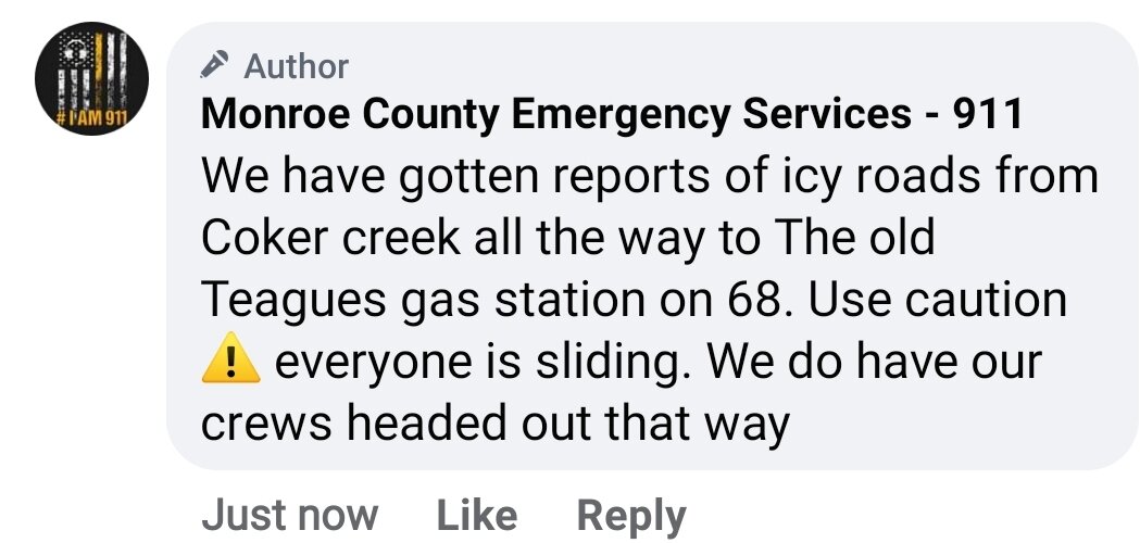
Very light freezing drizzle here...really messing up roads. Car flipped on the Hwy 411 bridge in Vonore
-
Roads here are iced over
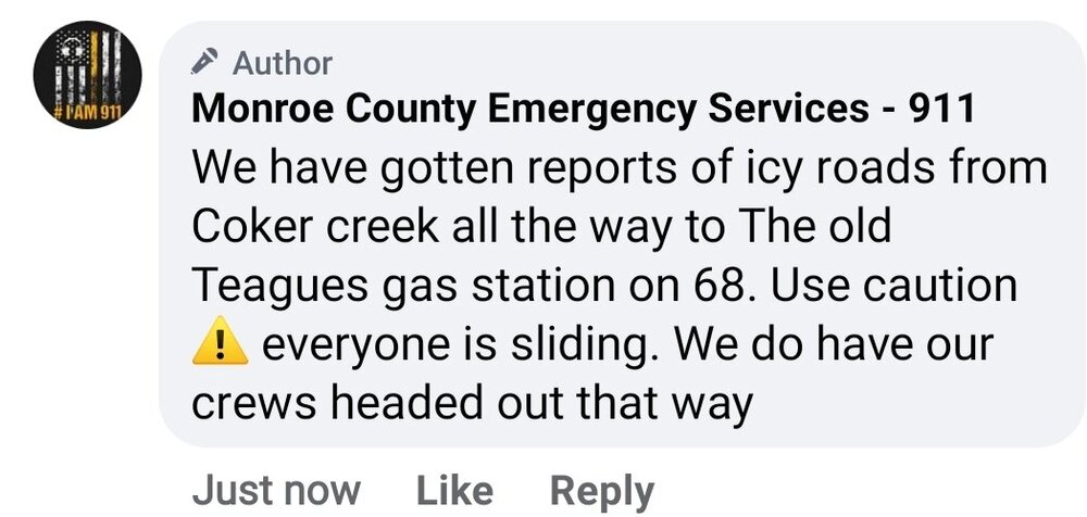
-
Picked up a quick dusting on elevated surfaces
-
Radar isn't picking it up, but have a moderate snow shower going here in Madisonville
-
Thanks John...and if you watch the last frame all 3 pieces of energy (Southwest, N. Plains, and ours) jumps back west almost exactly the same distance. Almost like it shifted the entire upper air pattern over NA in unison.
-
If you watch the 500mb vort map, you can follow the northern energy digging south. Earlier runs it digs thru the OH River valley. 0z digs it back into MO. Short range has been digging it to OK. Further west/southwest it can dig. The better odds of 1) able to spin a LP sooner (more west than currently) 2) increases the interaction with the energy over the south west.
-
GEFS jumped the energy as well...another jump like that and the GFS will look more like the short range models, and bring alot more into the game.
-
GFS is struggling right now...jumped ever piece of energy 150 or so miles west in North America @69h
-
GFS digging SW a little more, not sure how much it will help
-
MRX going to ride the NBM again
-
It and the NAM dig the northern energy more SW, allowing them to pickup the southern energy. GFS misses the connection but trails weakened form of the energy behind the initial (2nd wave). Euro misses and squashes the 2nd.
-
Something similar is what I believe is the most probable outcome (but who know, changes in 500 from run to run is bad right now). Not much separation in energy, depends on how far SE the initial front pushes/orientation and then multiple day overrunning with the waves following along the stalled front. Just don't buy any amped solution right now, week LP popping maybe.
-
12z GEFS increased valley thru Sat evening vs 06z.
-
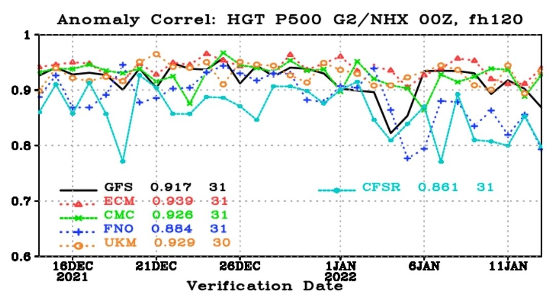
Think we are going to have more than the usual run to run variability in the short to medium range...so much energy in the 500 pattern coming up. Typically when you trend loop the 500 on models, they smooth out somewhere in the 60hr-84hr range. Currently it's in the 30hr-48hr range (GFS on the lower end). Model verification 120hr scores are starting to show this as well, with GFS currently not doing so well.

-
It had the areas right all way from AR to MS to TN, but was low to very low (depending on area)
-
Yeah thats another thing that surprised me..it moves at very slow increments up and down. It nearly doubled from 18z.
-
Good example of how conservative it is on accum maps, look at the KY/IL/IN area. Most models right now have at least a 2" swath thru there for the mid week system. But the NBM only puts out .5". So for it to be putting out 2" amounts in our area 5 days out seems like pretty loud honking from it.