

WxWatcher007
-
Posts
36,051 -
Joined
-
Last visited
Content Type
Profiles
Blogs
Forums
American Weather
Media Demo
Store
Gallery
Everything posted by WxWatcher007
-

Major Hurricane Melissa - 892mb - 185mph Jamaica landfall
WxWatcher007 replied to GaWx's topic in Tropical Headquarters
Yeah no recent microwave passes to confirm. Still, this is probably the most robust it’s looked yet. -
Major Hurricane Melissa - 892mb - 185mph Jamaica landfall
WxWatcher007 replied to GaWx's topic in Tropical Headquarters
It’s off to the races now. -
Major Hurricane Melissa - 892mb - 185mph Jamaica landfall
WxWatcher007 replied to GaWx's topic in Tropical Headquarters
This is such a sensitive track and intensity forecast. Just a few miles south or north would make a huge difference in intensity even though the catastrophic rainfall looks highly likely. -
Spooky Season (October Disco Thread)
WxWatcher007 replied to Prismshine Productions's topic in New England
For a beginner, is there a particular make/model that you’d recommend? -
Major Hurricane Melissa - 892mb - 185mph Jamaica landfall
WxWatcher007 replied to GaWx's topic in Tropical Headquarters
It’ll be crazy to see the transformation in 72 hours. Not as dramatic as Gabrielle, but dramatic nonetheless. -
Spooky Season (October Disco Thread)
WxWatcher007 replied to Prismshine Productions's topic in New England
Actually thinking of getting a snowmobile. Not sure where to start. -
Spooky Season (October Disco Thread)
WxWatcher007 replied to Prismshine Productions's topic in New England
After the decade that’s been we should be used to that by now. Yeah, but let’s see if that disappears at 00z. -
Major Hurricane Melissa - 892mb - 185mph Jamaica landfall
WxWatcher007 replied to GaWx's topic in Tropical Headquarters
They can but the environment is still exceptionally conducive for RI, and HAFS has been excellent in sniffing out the high end solutions. Milton being a prime example from last season. -
Spooky Season (October Disco Thread)
WxWatcher007 replied to Prismshine Productions's topic in New England
Nice to have something to track either way. A C4 getting pulled into Maine was never on the table. Hybrid at best, modest to strong nontropical coastal at worst unless that signal dampens. -
Do we know why that is?
-
Spooky Season (October Disco Thread)
WxWatcher007 replied to Prismshine Productions's topic in New England
Both ops kick Melissa with a very strong coastal low. Sub 980mb on both the GFS and Euro verbatim. -
I missed on Melissa by 12 hours, but this one is exactly what I talked about in Caribbean risk. It’s a powder keg.
-
Major Hurricane Melissa - 892mb - 185mph Jamaica landfall
WxWatcher007 replied to GaWx's topic in Tropical Headquarters
-
Spooky Season (October Disco Thread)
WxWatcher007 replied to Prismshine Productions's topic in New England
If that trough were cutting off near the Great Lakes, we’d really be in business. But that doesn’t look to be on the table. Too progressive and it gets kicked, so that makes all this a much lower likelihood from the start. -
Spooky Season (October Disco Thread)
WxWatcher007 replied to Prismshine Productions's topic in New England
If the EPS is right, we're squarely in the ballpark for some sort of hybrid or "TC guts" as Tip puts it. But what happens in the Caribbean has a huge impact on whether this is kicked or captured in some fashion, and that is a legitimate unknown right now. Location and speed will matter. There's going to be a lot of uncertainty in the coming days--more than usual, but it's hard to look at the EPS and GDMI and not be modestly intrigued. Again, pure tropical is a pipe dream IMO. If people are expecting that, close the shades. If we're talking hybrid though, nobody needs the center riding over their head for a highly impactful storm in New England or Atlantic Canada. A C3 or C4 wrapping into a substantial trough in the east would do, even if it's just off the coast (though if it's captured it'll come NW/NNW).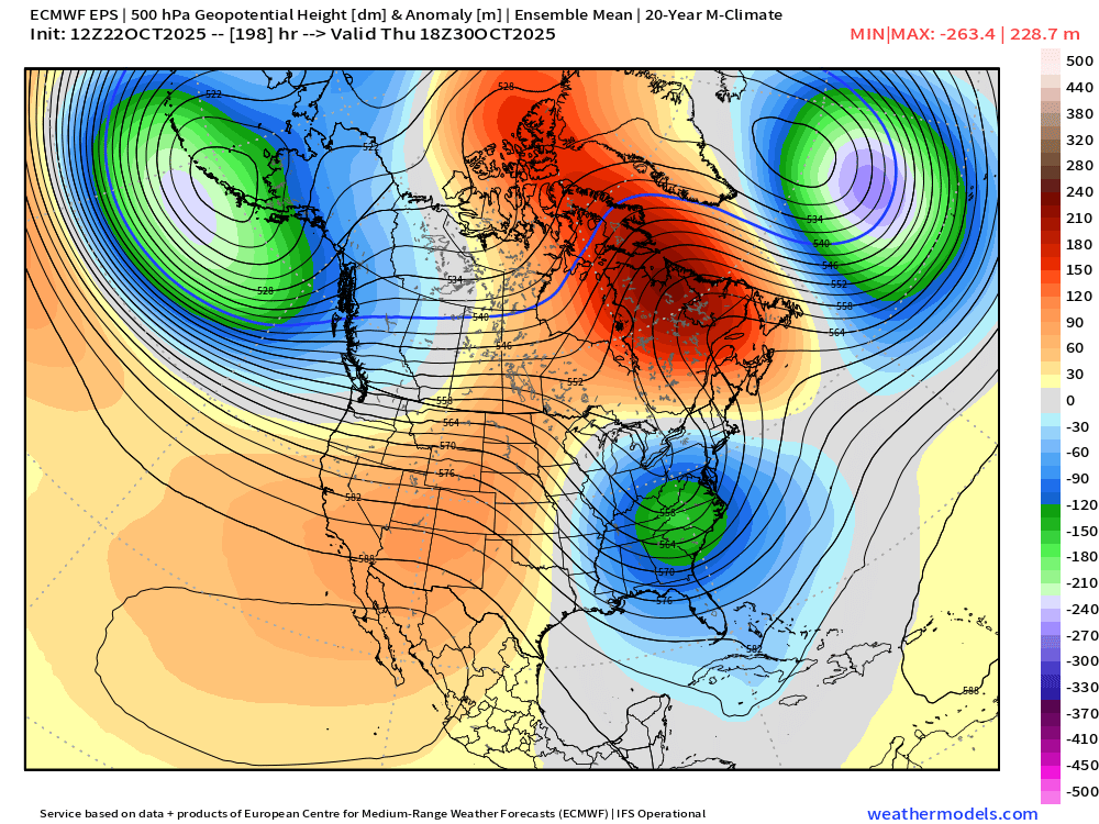
-
Spooky Season (October Disco Thread)
WxWatcher007 replied to Prismshine Productions's topic in New England
To Tip’s earlier point, irrespective of what happens with Melissa, there is a strong storm signal on the EPS. If there is any tropical infusion it’ll be a hell of a hybrid for us or Atlantic Canada. There are some absolutely nuclear solutions across guidance. -
Spooky Season (October Disco Thread)
WxWatcher007 replied to Prismshine Productions's topic in New England
Let’s get this inside 5 days before we’re talking about wind -
Spooky Season (October Disco Thread)
WxWatcher007 replied to Prismshine Productions's topic in New England
Clearly a lot to sort out but this might be interesting. October is still hybrid season.. -
Spooky Season (October Disco Thread)
WxWatcher007 replied to Prismshine Productions's topic in New England
Meanwhile, the euro and hurricane models continue to go nuclear in a few days. Jamaica is in deep trouble. -
Spooky Season (October Disco Thread)
WxWatcher007 replied to Prismshine Productions's topic in New England
Yep. A hell of a winter storm just over the border into Canada though verbatim. -
Spooky Season (October Disco Thread)
WxWatcher007 replied to Prismshine Productions's topic in New England
I’ll never forgive T-Blizz for complaining his way to a jackpot in the 2022 blizzard while I was shoveling pixie dust. -
Spooky Season (October Disco Thread)
WxWatcher007 replied to Prismshine Productions's topic in New England
Maine sent back to the days of being the Massachusetts Bay Colony. -
Major Hurricane Melissa - 892mb - 185mph Jamaica landfall
WxWatcher007 replied to GaWx's topic in Tropical Headquarters
Tropical Storm Melissa Discussion Number 5 NWS National Hurricane Center Miami FL AL132025 1100 AM EDT Wed Oct 22 2025 While Melissa continues to produce bursting convection on satellite imagery, with very cold cloud tops down to -95C, there is little evidence these convective bands are wrapping around the center. West-northwesterly shear of 20 to 25 kt is currently preventing the low-level and mid-level circulation centers from aligning. This downshear tilt with height has also been observed by the latest Air Force Reconnaissance mission, which reported significant winds at the surface in their most recent 850 mb center drop. The initial intensity for this advisory is held at 45 kt, taking a blend of recon observations which had a peak wind of 52 kt at 850 mb, and satellite intensity estimates from TAFB, ADT, and D-MINT. The wind field of Melissa also remains very asymmetric, as evidence of a recent 1040z RCM-1 Synthetic Aperture Radar pass showing the bulk of tropical-storm-force winds east of the center. The tropical storm has slowed down to a crawl this morning, with the estimated motion at 300/2 kt. The track forecast remains challenging today, and strongly related to the storm's structure in the short-term. For the next 12-24 hours, Melissa is forecast to move very slowly to the northwest as it attempts to move into a weakness produced by an broad upper-level trough centered over the Bahamas. Whether or not it turns more rightward into this weakness is related to the vertical depth the various model guidance is depicting. The 06z GFS run, which is the model that has been on the right side of the guidance envelope for days, shows a more vertically coherent system over the next 24-48 hours, and causes Melissa to abruptly turn northeastward over the next 48 hours. While this appears to be an outlier solution, the Google DeepMind ensemble mean (GDMI) also shows this northeastward motion, and a significant fraction of its ensemble members show the Melissa making landfall on the Island of Hispaniola. However, the remainder of the track guidance, including the ECMWF and its ensemble mean, suggest that Melissa will remain misaligned and move more slowly north-northwest over the next couple of days. The NHC track solution slightly favors the latter scenarios, lying just east of the ECMWF mean, out of respect of the reliable GDMI aid. After about 60 h, mid-level ridging begins to build back in to the north, and most of the guidance responds by showing a sharp turn westward, albeit still at a snail's pace. The overall track guidance, GFS and GDMI excluded, has shifted left this cycle beyond 72 h, and the NHC track was shifted in that direction, but not as far south and west as the HAFS-A/B regional models. It goes without saying, this is a very challenging track forecast. The intensity forecast has its own share of challenges. At least in the short-term, vertical wind shear is expected to persist between 20 to 30 kt, and will likely prevent Melissa from becoming fully aligned and taking advantage over the very warm 30-31C sea surface temperatures. After about 48 hours, the GFS and ECMWF-based SHIPS guidance shows the shear decreasing gradually, but the timing on when the system becomes more vertically coherent varies among both the global and hurricane-regional model guidance. Most of the guidance shows significant or even rapid intensification in days 3-5, and the NHC intensity forecast was raised once again during this time frame, but not as high as the HCCA or hurricane-regional models due to continuity constraints to the previous forecast. The day 5 forecast now shows Melissa becoming a major hurricane, and further upward adjustments may be necessary in subsequent cycles. The intensity forecast is also more uncertain than usual, in large part related to the track uncertainty. Key Messages: 1. Melissa is expected to produce heavy rainfall across portions of the Dominican Republic, Haiti, and Jamaica through this weekend, bringing a risk of significant flash flooding and landslides. 2. Hurricane conditions are possible in the southwestern peninsula of Haiti where a Hurricane Watch is in effect. A Tropical Storm Watch is in effect for Jamaica. Preparations to protect life and property should be completed by Thursday. 3. There is significant uncertainty in the track and intensity forecast of Melissa. Interests elsewhere in Hispaniola and Cuba should continue to monitor the latest forecasts. FORECAST POSITIONS AND MAX WINDS INIT 22/1500Z 14.4N 73.6W 45 KT 50 MPH 12H 23/0000Z 14.8N 73.9W 45 KT 50 MPH 24H 23/1200Z 15.2N 74.3W 50 KT 60 MPH 36H 24/0000Z 15.6N 74.4W 55 KT 65 MPH 48H 24/1200Z 16.0N 74.4W 55 KT 65 MPH 60H 25/0000Z 16.3N 74.6W 60 KT 70 MPH 72H 25/1200Z 16.5N 74.9W 70 KT 80 MPH 96H 26/1200Z 16.6N 75.8W 90 KT 105 MPH 120H 27/1200Z 16.4N 77.4W 105 KT 120 MPH $$ Forecaster Papin -
Spooky Season (October Disco Thread)
WxWatcher007 replied to Prismshine Productions's topic in New England
Sorry, didn’t mean to derail the thread… -
Spooky Season (October Disco Thread)
WxWatcher007 replied to Prismshine Productions's topic in New England
Yeah the shear is unquestionably there currently and will remain, I don’t doubt that, but in a few days as Melissa shifts west and the ULAC becomes the predominant feature, that’s when the window for explosive development is most likely. Still not a guarantee, but looking increasingly likely. Ironically, it’s the 20-30kt of shear now that is keeping Melissa from becoming vertically aligned that will probably lead to a further west track. Melissa can’t muster a sprint into the weakness to its north. From the latest NHC forecast The intensity forecast has its own share of challenges. At least in the short-term, vertical wind shear is expected to persist between 20 to 30 kt, and will likely prevent Melissa from becoming fully aligned and taking advantage over the very warm 30-31C sea surface temperatures. After about 48 hours, the GFS and ECMWF-based SHIPS guidance shows the shear decreasing gradually, but the timing on when the system becomes more vertically coherent varies among both the global and hurricane-regional model guidance. Most of the guidance shows significant or even rapid intensification in days 3-5, and the NHC intensity forecast was raised once again during this time frame, but not as high as the HCCA or hurricane-regional models due to continuity constraints to the previous forecast. The day 5 forecast now shows Melissa becoming a major hurricane, and further upward adjustments may be necessary in subsequent cycles. The intensity forecast is also more uncertain than usual, in large part related to the track uncertainty.


