Ellinwood
-
Posts
6,210 -
Joined
-
Last visited
Content Type
Profiles
Blogs
Forums
American Weather
Media Demo
Store
Gallery
Everything posted by Ellinwood
-
 Temps got knocked down several degrees IMBY (to lower 60s)... 1-hour temperature change plotted. Some time to recover this afternoon but we'll see.
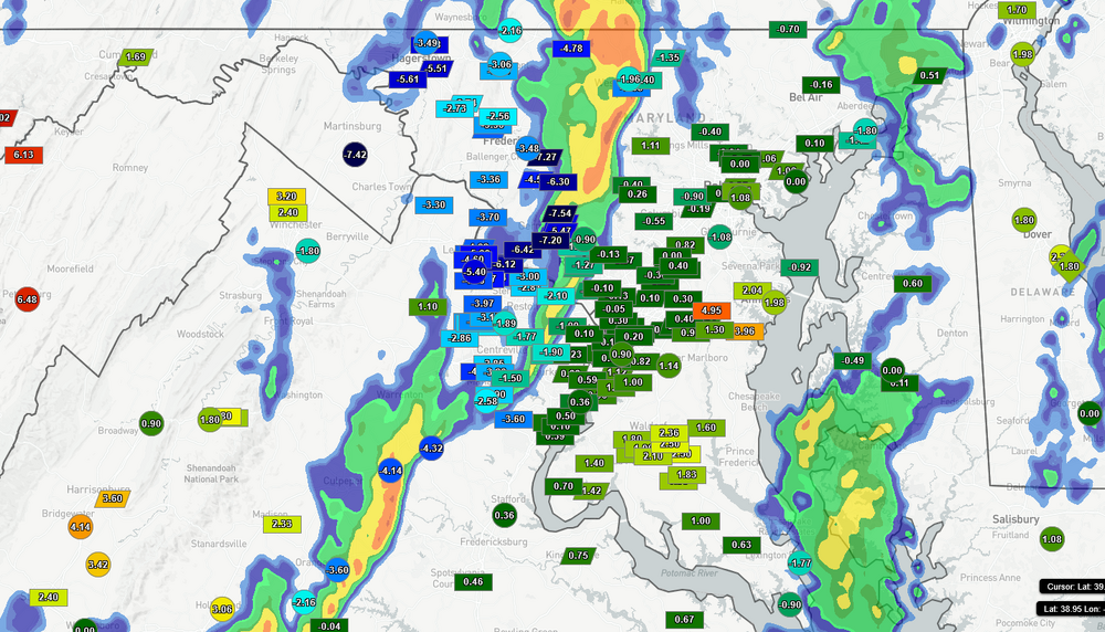
-
I live near there and got basically the same picture. Good wind-driven rain but no lightning. Clarksburg circulation went over my MIL's apartment but she's okay (nothing to report apparently).
- 1,093 replies
-
- 2
-

-
- severe
- thunderstorms
- (and 1 more)
-
Man I didn't realize so many Mid-Atlantic severe peeps are on the Doom-And-Gloom Express (based on last night's posts). Need to reprise my role of hype man for these events.
-
Highly dependent on the setup, but for tomorrow I'm looking for CAPE >500 (with closer to 1000 for the higher-end scenarios). I'd emphasize that this isn't a GO HIDE ALL AFTERNOON scenario so much as you don't want to be caught out and about if/when the storms roll through. The higher-end stuff will probably be pretty localized.
- 1,093 replies
-
- 5
-
-
- severe
- thunderstorms
- (and 1 more)
-
I was on the fence about messaging my kid's teacher saying I was gonna get my kid out early (we walk to/from school) so now I'm glad I don't have to make that decision myself
- 1,093 replies
-
- 5
-
-
- severe
- thunderstorms
- (and 1 more)
-
I need to post more. the tl;dr is I could care less about the tornado potential since the wind is the big story and I ain't chasing no storms going 50+ mph through this region. Doesn't seem like an "everyone gets hit" setup but the more potent stuff looks like it's gonna hit hard where it hits.
- 1,093 replies
-
- 13
-
-

-
- severe
- thunderstorms
- (and 1 more)
-
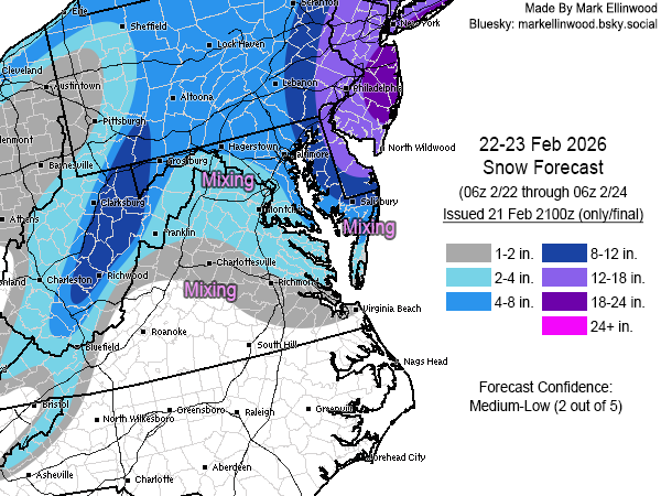
Feb 22nd/23rd "There's no way..." Obs Thread
Ellinwood replied to Maestrobjwa's topic in Mid Atlantic
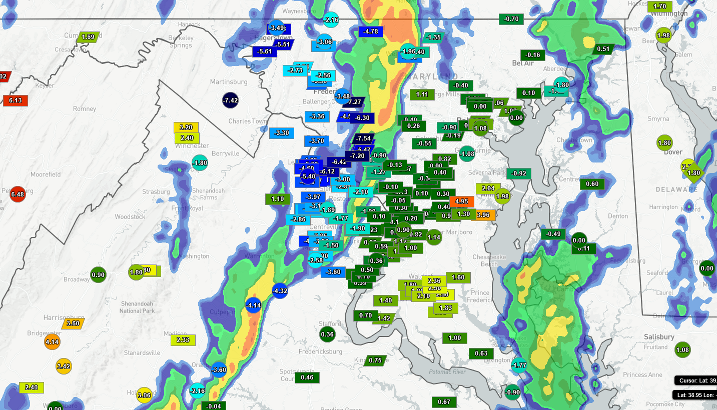
Road accumulation is just starting in Germantown. Around 0.5" on grass and elevated surfaces. -
lol I was just making a post when I saw the notification from this one Didn't deviate from the NWS much with my forecast... just some tweaks here and there. Won't bother going through the caveats because y'all know them, mainly the marginal surface temps and the lack of good rates inland.
-
Got 6" of snow in Germantown, MD before changing over to sleet around 8:45am... about 1-2" less than I wanted to see before the changeover across the region. Snowblower doesn't get used often but am glad I have it. Looking for 1-2" of sleet through this afternoon now. 14F and sleet is silly
-
January 24-26: Miracle or Mirage JV/Banter Thread!
Ellinwood replied to SnowenOutThere's topic in Mid Atlantic
Been a minute since I semi-regularly lurked a storm thread (mostly because our winters have been junk with respect to snow). Glad to see the forum hasn't changed -
Jan 24-26 Weekend Snow and Sleetfest Model Thread Part Tres
Ellinwood replied to H2O's topic in Mid Atlantic
Made more significant adjustments in the mountains and pulled back totals around the coast and the DMV region a little. Gonna be interesting to see how quickly things change over to sleet, but we all know that leaning earlier vs later is the way to go 90% of the time.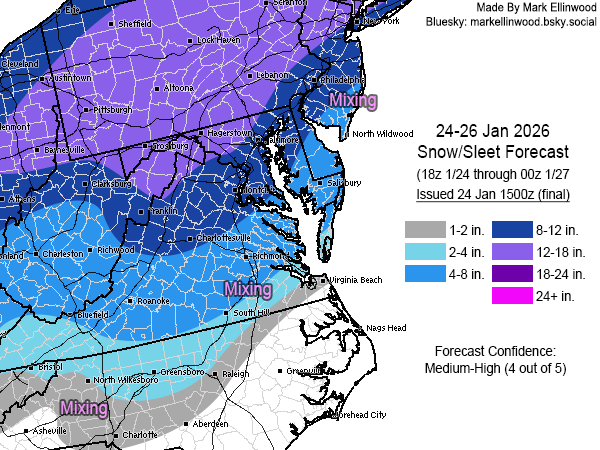
-
Mostly good ratios and strong cold air that we haven't seen ahead of a storm like this in quite some time. Sorry for being vague but I've never been one to write it all out since I'm usually too tired or burned out from work to write it.
-
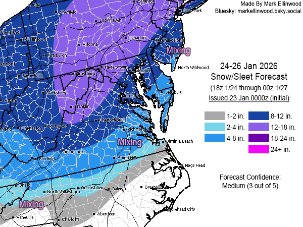
Initial snow+sleet forecast... main issue will obviously be the mixing that comes in on Sunday, mainly along and east of I-95. Very excited as my kid is 6 and has not seen a 6"+ snow event.
-
Had a little RASN in the morning and 10 minutes of flurries in the afternoon. Would rather have 0" than 1" of bs that I have to shovel with the cold coming in. Got 0.5" yesterday at least, before it all melted.
-
Can't write "what went wrong" until the storm's over Also it's not more of a "what went wrong" as it is uncertainty in the forecast and forecasters choosing which way they wanted to go. If nearly every model shows one solution and then that doesn't even come close to reality, that's when I look into it more.
-
Was hoping the models would bring the PM snow more in line with my track, but looking more like now this will be lower-end/under my forecast in the DMV region. I wasn't really relying on this morning's activity to do much south of the MD/PA border, but would have liked to see at least a coating IMBY by now instead of rain/mix.
-
Final map for Sunday... only notable change was to drag the 1-2" contour southward into the Raleigh metro region. Richmond northward is essentially the same as the initial forecast with just a few very minor adjustments.
-
First crack at Sunday... went pretty aggressive with a strong lean on the Euro+GFS AI guidance given how crazy consistent they've been with the track+QPF, with much less consistency among the traditional models. Southern and eastern areas dealing with some surface temp issues while western edge could change drastically if the system ends up weaker/more progressive than my forecast. Lower than normal confidence with this map.
-
I'm on board for today... think tornado potential is decent up to the MD/PA border.
- 1,378 replies
-
- 11
-
-

-
-

-
- severe
- thunderstorms
- (and 2 more)
-
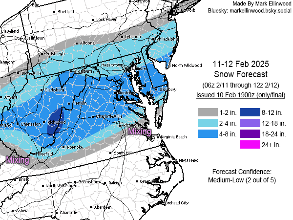
Snow forecast for February 11-12... lots of uncertainties with precip types on the south end and QPF amounts on the north end, and some areas could suffer rate issues during the afternoon. As a result, forecast confidence isn't that great.
-
1/19 - The Roulette Wheel 29 Black Storm - OBS
Ellinwood replied to DDweatherman's topic in Mid Atlantic
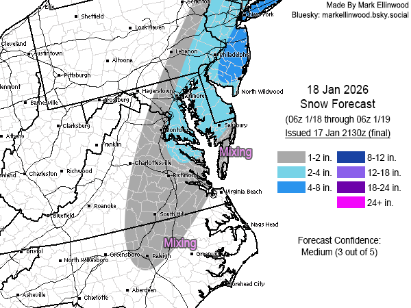
Final snow forecast for tomorrow. Good ratios where the snow can insta-stick mainly NW of I-95, with surface temp and snow rate concerns on the south side of the accumulations (especially during daylight hours).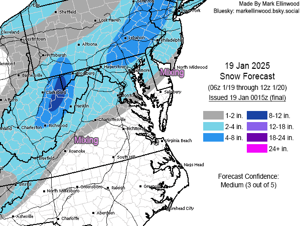
-
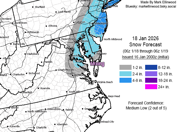
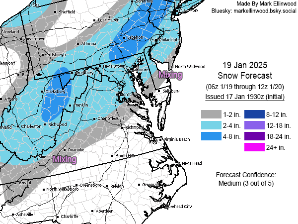
Snow forecast for Sunday. South side dealing with marginal surface temps and there could be accumulation issues if the rates aren't good enough during the daylight hours. QPF also a concern across the whole region as it will depend on coastal strength and track.
-
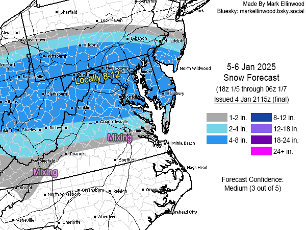
Final forecast as I will be too busy to work on it tomorrow. Shifted everything a bit south overall, especially east of the Appalachians. Still not buying huge snow totals on the south side given the mixing issues.
-
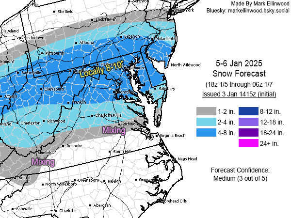
Initial snow forecast for January 5-6 (late Sunday into Monday). Favoring the cluster of more northern solutions overall, with some mixing issues showing up from D.C. southward (but not before a decent amount of snow). Euro's more southern track is certainly something to keep an eye on. Main concerns are with potential mixing in the southern areas cutting into totals, and sharpening up the northern gradient once there's better confidence in the track.
-
Yessir all is well. Will be getting a map together late morning.