Winter Wizard
-
Posts
689 -
Joined
-
Last visited
Content Type
Profiles
Blogs
Forums
American Weather
Media Demo
Store
Gallery
Everything posted by Winter Wizard
-

The last hurrah? Putting all the eggs in the Tuesday 3/14 basket
Winter Wizard replied to Ginx snewx's topic in New England
Haven’t had time to look at anything since, but this is my first call map from this morning. Should be a fun one for most of you!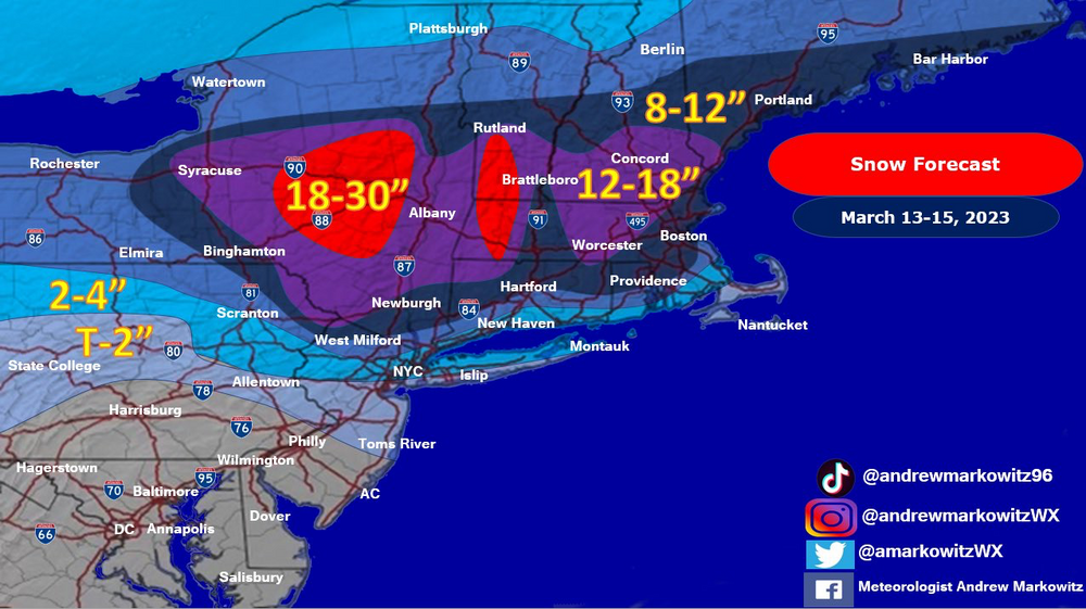
-
The last hurrah? Putting all the eggs in the Tuesday 3/14 basket
Winter Wizard replied to Ginx snewx's topic in New England
Way too bearish IMO. Big storm incoming. -
The last hurrah? Putting all the eggs in the Tuesday 3/14 basket
Winter Wizard replied to Ginx snewx's topic in New England
You basically have the full repertoire of outcomes on the table here...I suspect we're seeing the classic progressive GFS bias and Euro overamped bias at play here. Way too early to have any confidence in a call, but need to closely watch the interaction between the two streams: if the northern stream comes racing ahead then this will be a late bloomer scenario. If the southern stream races away then you get a much stronger storm initially and inland runner is on the table. Both scenarios seem equally plausible at this point, in my opinion. -
Even out there I see concerns with snow growth on the soundings. Certainly will continue to see wobbles in either direction, and I'm not saying that's the apt solution, but it shows just how quickly this threat can fall apart by only a slight margin of error.
-
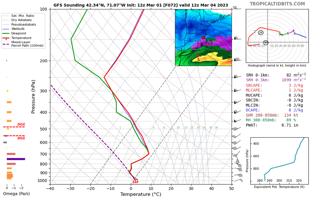
Gotta say this sounding isn't doing very much for me...not only do you have the warm nose within a margin of error, degree wise and temperature wise, but snow growth is unimpressive after an initial front end burst. Would exercise caution about using the Kuchera map here, as usual.
-
Feb 28th-March 1st long duration Miller B threat
Winter Wizard replied to George001's topic in New England
This was my map from this AM, no major changes after looking over today's guidance. If anything, would trim eastern Mass some (T-2 for the immediate coast and the Cape).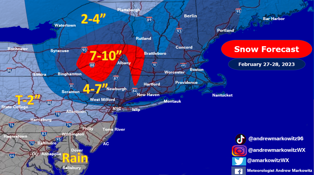
-
Feb 28th-March 1st long duration Miller B threat
Winter Wizard replied to George001's topic in New England
Lol you kind of get the worst of both worlds on that Euro, most of the region misses out on the WAA thump then the confluence shunts the coastal low to the southeast. NNE is smoking cirrrus. -
Feb 28th-March 1st long duration Miller B threat
Winter Wizard replied to George001's topic in New England
I actually thought the GFS was an improvement, farther N and W with the primary low and then weaker confluence to the north provides a bit more coastal enhancement. That's still good for a widespread 6-12", in this winter I certainly would be happy with it. Would be a quick mover though without any mechanism to slow it down, unlike those wild solutions from yesterday. -
Feb 28th-March 1st long duration Miller B threat
Winter Wizard replied to George001's topic in New England
A warning event is still very much on the table for most of the forum and would be a huge victory with how the winter has gone. There have been clear modes of failure with this one to prevent it from becoming a big dog. -
Feb 28th-March 1st long duration Miller B threat
Winter Wizard replied to George001's topic in New England
I don’t have reanalysis handy, but how does this setup compare to 2/9/15? -
Feb 28th-March 1st long duration Miller B threat
Winter Wizard replied to George001's topic in New England
Primary is still nuking over Lake Ontario at that point. -
Feb 28th-March 1st long duration Miller B threat
Winter Wizard replied to George001's topic in New England
Cut that Kuchera map down by at least half, front end is going to be paste. Back end, sure, you'd see 12-15:1 ratios most likely. Even though it's a very nice run for the Pike region, I don't think it does much to quell concerns: you get a quick front end thump and then you're banking on fickle IVT snows from a late developing coastal. Flow is still very progressive. -
Feb 28th-March 1st long duration Miller B threat
Winter Wizard replied to George001's topic in New England
Looks like the east leaning members converged back to the west. Going to introduce p-type issues near the coast if that holds. -
Feb 28th-March 1st long duration Miller B threat
Winter Wizard replied to George001's topic in New England
Yesterday's runs were Goldilocks solutions and I don't think it's surprising at all that if you adjust the timing and positioning of certain features, all of a sudden the ceiling becomes much lower. Not saying this is a similar progression as what we saw in mid-late December, but it's a good reminder that the setup can be textbook but if certain pieces are misaligned, then it won't come together. All in all, with how this winter has gone, I don't think you can complain about a 6"+ mean with this lead time. -
Feb 28th-March 1st long duration Miller B threat
Winter Wizard replied to George001's topic in New England
I would be much more concerned about a whiff north than missing south. The primary decays a bit too late for me to feel comfortable and the tendency this season has been to weaken confluence over Canada. -
It's a pretty bizarre evolution and IMO the primary decays a bit too late for my liking. Having the -NAO and pivoting 50/50 Low certainly does raise the bar for if/where this develops.
-
Agreed, this does not look close to December in terms of magnitude of the blocking. NAO is much more meaningful for Europe than the US anyway. Certainly strong agreement that Canada will be chillier than normal but not sure how much of that will seep into the US besides the Upper Midwest and the Rockies.
-
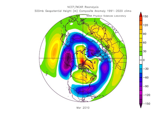
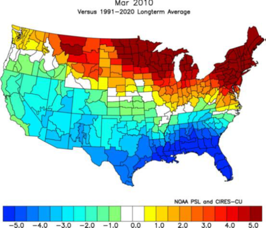
March 2010 is a great example of how a -NAO block in March far from guarantees a cold pattern developing. If you look at the other cold/snowy March cases recently that had NAO/AO blocking, it was because there was help in the Pacific domain. Currently I'm hard pressed to see the Pacific working in the East Coast's favor for the foreseeable future.
-
The 2/23 threat definitely has legs in New England, IMO. Key difference from December is now we'll have the 50/50 this time in addition to the -EPO and an east-based NAO block. You can certainly thread the needle with that depiction but the timing is delicate: if it comes in too soon, then this will be sheared and suppressed, but too late and this is another cutter.
-
The event of the season - 2 days of hell!
Winter Wizard replied to Go Kart Mozart's topic in New England
For reference, at this time on 2/13/16, BOS was 12 degrees https://www.wunderground.com/history/daily/us/ma/east-boston/KBOS/date/2016-2-13 -
The event of the season - 2 days of hell!
Winter Wizard replied to Go Kart Mozart's topic in New England
I feel decently confident in saying that with the delayed movement in the front, BOS will go below -10 tonight. -
You can still score a decent overrunning event if things align correctly, but those usually favor New England. Does not scream KU though without those features.
-
The upcoming pattern certainly seems like December deja vu. EPO block rivaling December's (which has trended stronger every day since 0z Thursday) will dump the extreme cold into the N Rockies and Plains but will struggle to make it to the East Coast until probably the end of next week thanks to the SE ridge. Then there will be a few days below average, but as blocking retreats, we return to the canonical Nina pattern and I think the Northeast torches yet again while the West is cool and stormy. If things align, I think there could be a good opportunity to score something in the 2/2-2/7 timeframe as the Metro rides the boundary between polar cold to N and W and the lingering SE ridge, but after that, I don't see much to be enthused about.
-
At first glance, I could see this playing out similarly to the Super Bowl storm last year, which clocked the South Shore, in a high end scenario. Certainly have a pronounced FGEN signal but soundings show a good amount of dry air in the mid-levels.
-
IMO the cold period, if it does happen, wouldn't be until the 28th or so. I suspect the back end of January follows a similar progression to December where the West cools down first once the Asian-Pac jet relaxes, likely around 1/20, then slowly progresses eastward. After that, Nina climo generally favors a return to a -PNA pattern and strong SE ridge for February. It isn't pretty.