hudsonvalley21
-
Posts
4,072 -
Joined
-
Last visited
Content Type
Profiles
Blogs
Forums
American Weather
Media Demo
Store
Gallery
Everything posted by hudsonvalley21
-
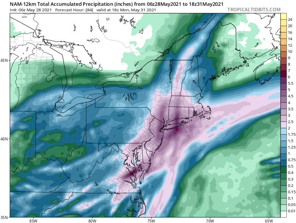
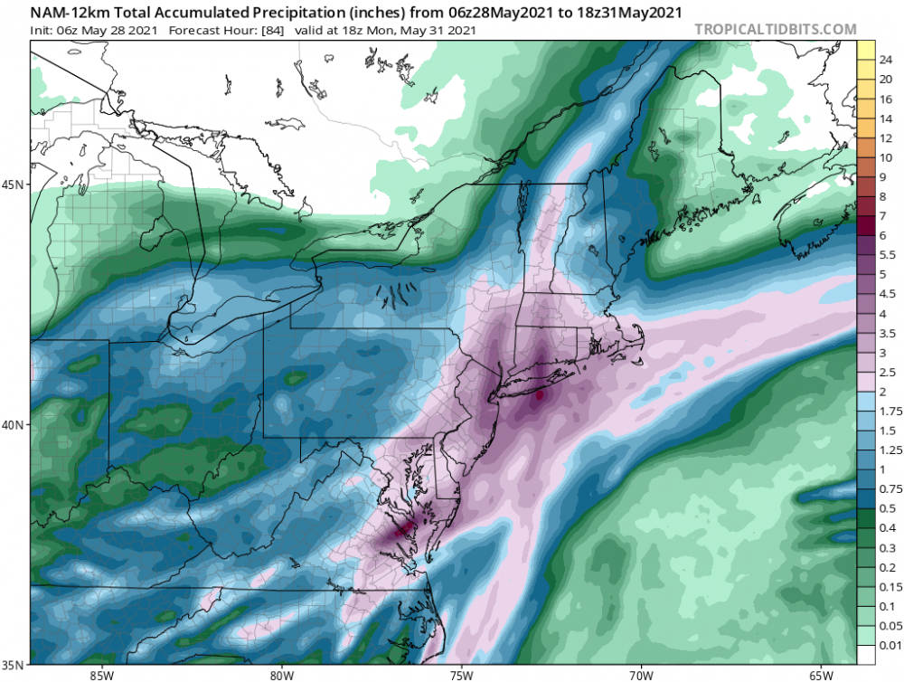
1.10 so far up my way.
-
1.10 in the bucket so far.
-
06z NAM says super soaker
-
Got me beat .05 here.
-
90/64 here. Watch now up, with the s/w surface flow no marine influence should knock down what development happens up in our region. Severe Thunderstorm Watch Number 206 NWS Storm Prediction Center Norman OK 245 PM EDT Wed May 26 2021 The NWS Storm Prediction Center has issued a * Severe Thunderstorm Watch for portions of Western Connecticut District Of Columbia Delaware Maryland New Jersey Southeast New York Eastern Pennsylvania Northern Virginia Eastern Panhandle of West Virginia Coastal Waters * Effective this Wednesday afternoon and evening from 245 PM until 1000 PM EDT. * Primary threats include... Scattered damaging wind gusts to 70 mph possible Isolated large hail events to 1 inch in diameter possible SUMMARY...Thunderstorms are expected to continue to develop over parts of Pennsylvania and spread eastward across the watch area through the evening hours. Damaging winds will be the main threat with the strongest cells. The severe thunderstorm watch area is approximately along and 65 statute miles north and south of a line from 45 miles northwest of Staunton VA to 5 miles south southeast of Lakehurst NJ. For a complete depiction of the watch see the associated watch outline update (WOUS64 KWNS WOU6).
-
0.91 in the bucket for the 2 day event total.
-
DCA: +2.1 NYC: +2.0 BOS: +1.8 ORD: +1.9 ATL: +1.1 IAH: +2.6 DEN: +2.7 PHX: +2.0 SEA: + 0.6
-
Over this way last night had 0.18 with only a rumble of thunder. Event total ( includes last nights ) 0.24 as of 6am.
-
1.05 is the total here
-
1.05 is the total here.
-
0.87 as of 10:30 pm.
-
0.87 as of 10:30 pm.
-
0.58 here. 45/43 currently.
-
0.58 here. 45/43
-
I’m going to put away the snow shovels to help this thing along

-
Total of 0.20 in the bucket since noon Friday thru noon today.
-
0.20 in the bucket since noon Friday thru noon Monday (today)
-
Horse farms were often visited by many folks to take from their compost piles for garden use and that was back in the 70’s that I remember. The farmers were more than happy to get rid of it.
-
Hope you not finding it on the bottoms of your shoes. And I’m not referring to the twigs
-
Yup big difference. I was at my daughters home in Goshen yesterday and it’s just starting to turn green there with little growth.
-
Walt’s post from the April thread, No thread on my part but three more opportunities for snow lurk in our subforum. later tonight ne PA/nw NJ, probably no big deal tho 1/2" possible higher terrain ne PA. Then the 9th-11th (next Fri-Sun), Potential for a pretty big long duration periodic rain event (1"+) with wind (40kt) for a part of the sub forum coast with high terrain wet snow possible. Ensembles don't favor snow, certainly nothing like the 00z/3 EC snow depth forecast (just nw NYC). There's even something during mid month? Keeping an eye on it. Figure future modeling will shrink the snow, not sure the sizable storm will disappear in what appears to me to be a favorable blocking pattern for a slow mover somewhere along the Mid Atlantic Coast.
-
Walt has mentioned it in the April thread that we have a few more shots at some possible wintery type events in the next couple of weeks. As for the wind events what a year for multiple spring cleanups.
-
That’s what happens when you get old. By the way where’s my blanket.
-
Should I jinx it and say I’m bringing out the lawnmower?