Sydney Claridge
-
Posts
533 -
Joined
-
Last visited
Content Type
Profiles
Blogs
Forums
American Weather
Media Demo
Store
Gallery
Everything posted by Sydney Claridge
-

Severe Weather 5-6 through 5-9-24
Sydney Claridge replied to cheese007's topic in Central/Western States
The area between I-70 in Kansas and I-40 in Oklahoma has really lit up with supercells now. It's only a matter of time before we start seeing this tornado outbreak begin in earnest. We have two tornado-warned cells in northwest Oklahoma now, one by Waynoka and now the cell east of Mutual. -
Severe Weather 4-25 through 4-28-24
Sydney Claridge replied to cheese007's topic in Central/Western States
PDS tornado warning in the Sulphur area states that “First responders need to prepare for additional tornado impacts immediately!” I have never seen such wording in a tornado warning before. They had another tornado go through earlier, so that goes to show you how dire this situation could be. -
Severe Weather 4-25 through 4-28-24
Sydney Claridge replied to cheese007's topic in Central/Western States
The last of the visible satellite is showing a decent initiation attempt along the Red River with this storm. Obviously the best severe potential is further west, but it still needs to be watched closely. I’m pretty sure these initiation attempts might be associated with the LLJ given their south-to-north movement.
-
Severe Weather 4-25 through 4-28-24
Sydney Claridge replied to cheese007's topic in Central/Western States
The storm that has gone up over the Tioga, TX and Whitesboro, TX areas north of DFW needs to be watched closely. It is not (yet) severe, but the reflectivity and echo tops look to be increasing. If it can strengthen as it moves into southern Oklahoma, it is completely isolated. -
Severe Weather 4-25 through 4-28-24
Sydney Claridge replied to cheese007's topic in Central/Western States
It looks like there might be some attempts at storm initiation over the DFW area, but I’m not sure if something will emerge from that. -
Severe Weather 4-25 through 4-28-24
Sydney Claridge replied to cheese007's topic in Central/Western States
The Eppley livecam on WOWT was just hit by a tornado that touched down at Eppley. -
Severe Weather 4-25 through 4-28-24
Sydney Claridge replied to cheese007's topic in Central/Western States
Looks like some of the neighborhoods on the north side of Elkhorn, around Arbor View Elementary, were hit, based on the movement of the velocity signature and debris ball. EDIT: WOWT live stream just mentioned gate-to-gate shear of around 200 MPH, 100 in one direction and 105 in the other. -
Severe Weather 4-25 through 4-28-24
Sydney Claridge replied to cheese007's topic in Central/Western States
A very concerning scenario unfolding in the western suburbs of the Omaha metro. -
Severe Weather 3-31 through 4-3-24
Sydney Claridge replied to cheese007's topic in Central/Western States
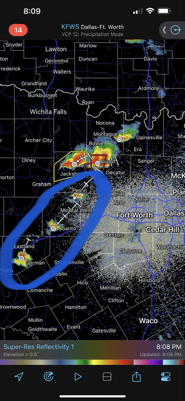
The storm between Springtown and Boyd bears watching as it moves into the DFW metro area. The hail intensity on radar seems to be increasing.
-
4/1-4/2 severe threat (southern portion of subforum)
Sydney Claridge replied to largetornado's topic in Lakes/Ohio Valley
The High Risk on March 2, 2012 did get into Ohio, with the 15% hatched (and MDT) encompassing the Columbus metro, but the sigtor threat didn't really materialize north of the Ohio River Valley in the state of Ohio. I'm getting flashbacks to that day looking at the model runs and SPC outlook, although SPC currently has the greatest risk for tomorrow outlined northeast of where they had the highest risk on 3/2/12. It looks like this CIPS analog run is showing 3/2/2012 (3/3/2012 at 0z) as the top analog for tomorrow, interestingly enough. -
Severe Weather 3-13 through 3-16-24
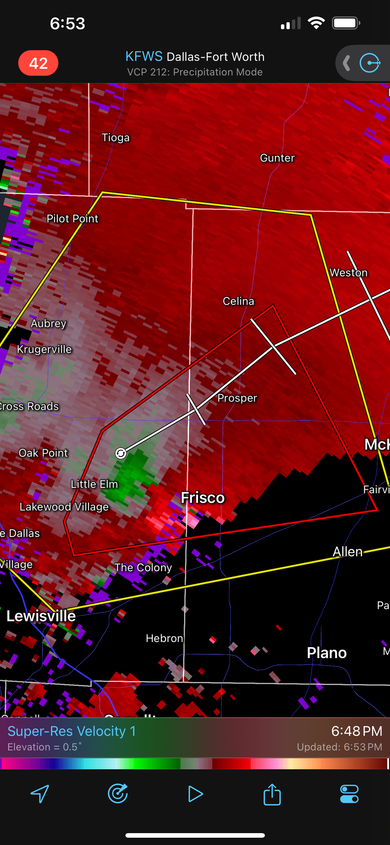
Sydney Claridge replied to cheese007's topic in Central/Western States
We have a tornado warning in the Frisco, TX area now. Somewhat broad rotation but it bears close watching; the hail is a huge threat regardless of any tornadic activity, though.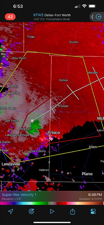
-
Severe Weather 3-13 through 3-16-24
Sydney Claridge replied to cheese007's topic in Central/Western States
It’s also pretty interesting to see all of this happening near a radar site, too. The storms over the Kansas City metro also bear watching; the atmosphere there (per SPC Mesoanalysis) also seems primed for potential tornadic activity. Fortunately those storms seem to be behaving themselves (rotation-wise), but I did notice some weak rotation around Shawnee. It’s not really “behaving” though; there’s a hailstorm in the KC metro now. -
Severe Weather 3-13 through 3-16-24
Sydney Claridge replied to cheese007's topic in Central/Western States
Looks like they have. This looks like some serious rotation near Alta Vista, KS: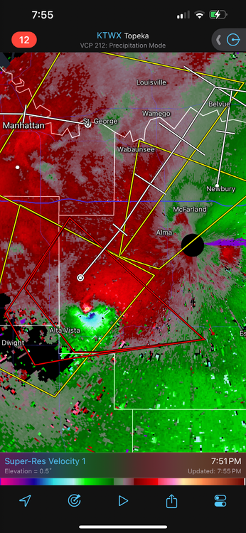
-
Texas 2024 Discussion/Observations
Sydney Claridge replied to Stx_Thunder's topic in Central/Western States
It’s 75 here in Fort Worth today! Absolutely beautiful. Seems like we’re expected to see highs in the 70s through Thursday, with rain (and thunderstorms) returning Friday. -
Severe Threats: Winter 2023-2024
Sydney Claridge replied to Chinook's topic in Central/Western States
Tornado confirmed near Coldspring, TX, per tornado warning text and KHOU livestream. EDIT: spotter-confirmed. -
I agree. The center of the eye looks to be onshore now.
-
I noticed a Flash Flood Warning for east-central Ventura County, issued at 420 PM PDT, that mentioned rockslides and mudslides along California Route 150. Obviously, Hilary's precipitation alone can do this, but shaking saturated ground could trigger slides when they might not otherwise occur.
-
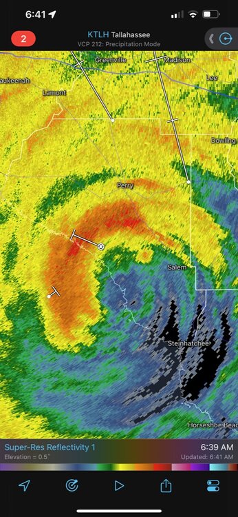
15/8/4
-
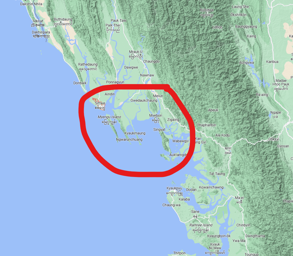
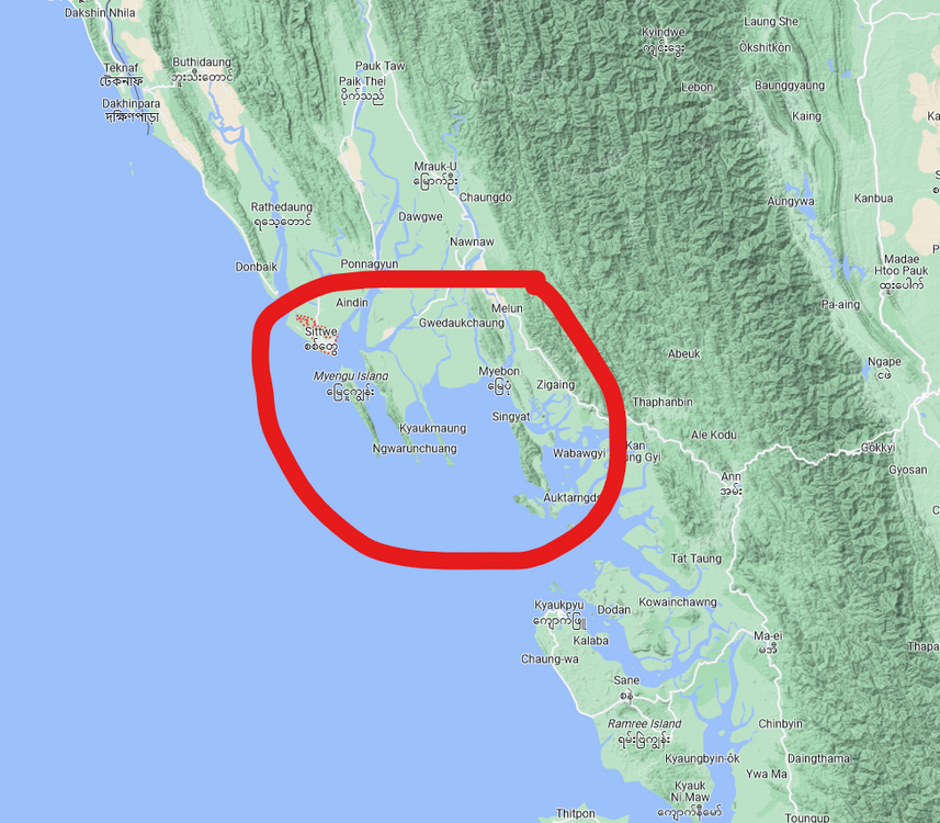
The orientation of the coastline in the Sittwe area definitely has me concerned about locally-enhanced storm surge. Mocha's strength and motion, along with the overall orientation of the coastline, are reminding me of Hurricane Ian, although there are great differences in topography (notice the hills and mountains running parallel to the coast). Those lowlands are in big trouble. I've extremely concerned about any humanitarian crisis that will follow Mocha's landfall. EDIT: it looks like I'm not too far off with respect to the highlighted area of concern, at least according to this forecast.
-
If at least one of these storms can manage to turn supercellular, I wonder if it could become a concern for the DFW metro?
-
Severe Weather 4-25 through 4-28-23
Sydney Claridge replied to cheese007's topic in Central/Western States
Might want to extend this thread into the 28th; we have another severe thunderstorm threat on Friday it seems. (cheese007 made the edits while I was posting this) SPC is mentioning a large hail threat (30% hatched, hence the ENH), along with some tornado potential especially in north TX if storms don't get undercut (currently 5% on the outlook). DFW dodged a bullet yesterday (4/26), so we'll have to see if we can do it again tomorrow (4/28) or if our luck will run out; I know some of the model runs in the run-up to yesterday were showing the activity closer to and over DFW. I always get a little concerned when there's a localized severe storm threat centered on DFW.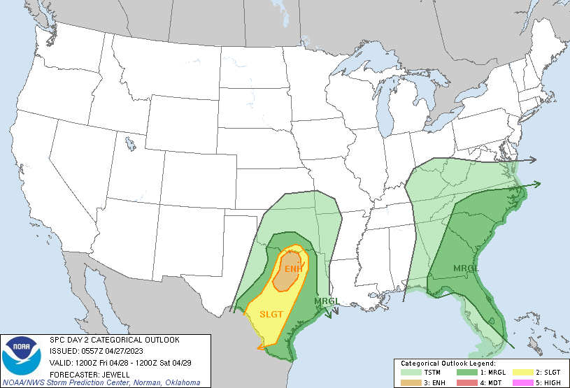
-
Severe Weather 4-2-23/4-3-23
Sydney Claridge replied to weatherextreme's topic in Central/Western States
Possible rotation trying to form in the Newark and Rhome areas? Seems like the Tarrant/Denton county line needs to be watched very closely just in case.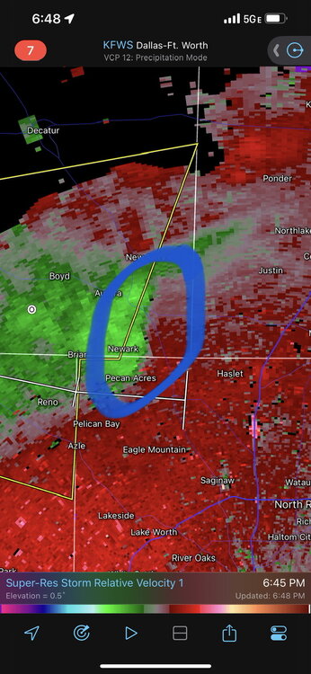
-
Texas/Oklahoma Discussion & Obs Thread 2022
Sydney Claridge replied to It's Always Sunny's topic in Central/Western States
There's a severe-warned storm along the US 59 corridor NE of Victoria and SW of Houston (near Edna) that looks ready to take advantage of the warm sector. -
January 2nd and 3rd Severe Weather Threat
Sydney Claridge replied to DanLarsen34's topic in Central/Western States
Although (obviously) I expect the greatest threat for severe thunderstorms to be east of DFW, I am starting to wonder about our risk on Monday. We are on the edge of the outlined D4 risk after all, and recent Euro (12z) and GFS (12z; waiting on the 18z) runs suggest the potential for a severe risk around noon; obviously this time frame can change! While morning severe is unusual, after the December 13th tornadoes I'm a little more alert to things like that. -
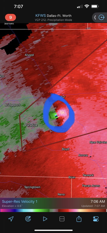
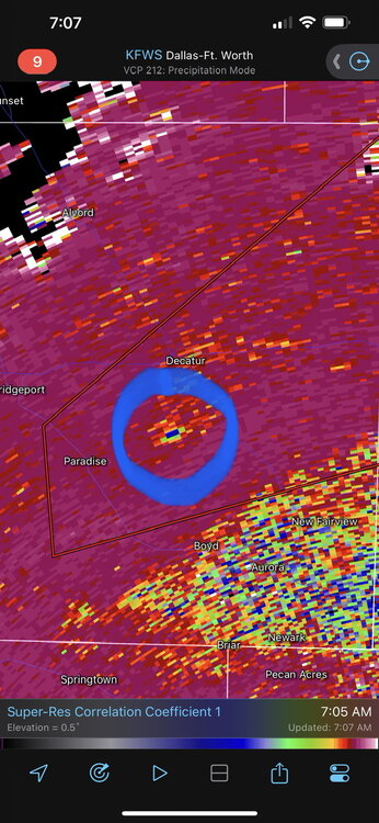
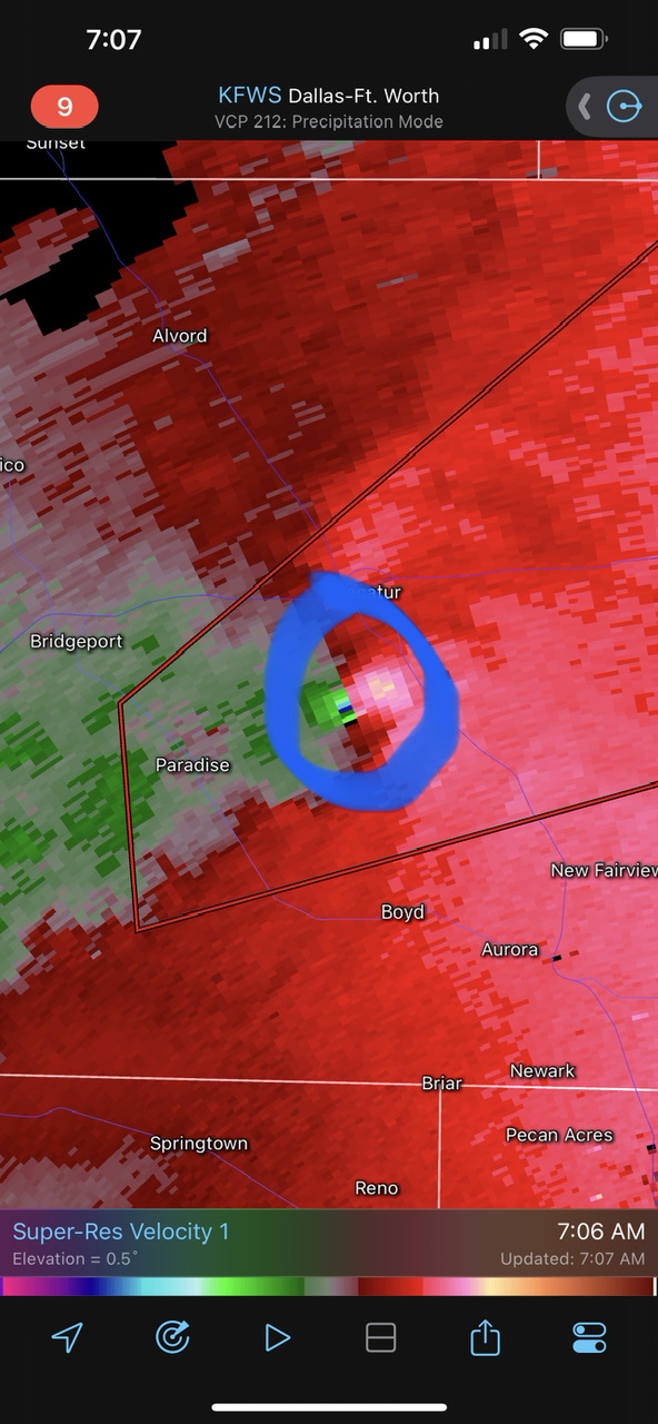
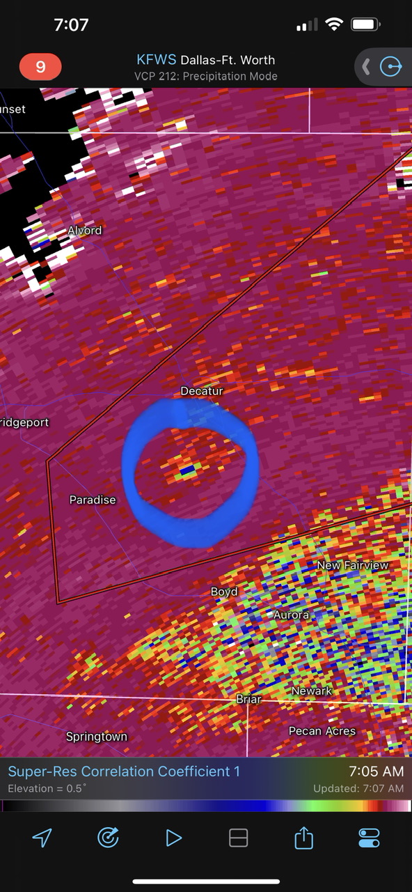
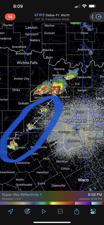
This is a concerning situation for areas in southern Decatur and south of Decatur.