
.png.2082198afdafcedf9ad03f1d6dfb7336.png)
HIPPYVALLEY
-
Posts
32,714 -
Joined
-
Last visited
Content Type
Profiles
Blogs
Forums
American Weather
Media Demo
Store
Gallery
Everything posted by HIPPYVALLEY
-
.thumb.png.4150b06c63a21f61052e47a612bf1818.png)
At least it's something - Jan 16th Snow/Sleet/Ice OBS Thread
HIPPYVALLEY replied to The 4 Seasons's topic in New England
Crappy growth but still light snow in Greenfield. -
At least it's something - Jan 16th Snow/Sleet/Ice OBS Thread
HIPPYVALLEY replied to The 4 Seasons's topic in New England
Fun place to hang out, live music etc. Beer is just ok. The double bottom IPA, Belgian Wit and Hurricane Porter are decent. -
At least it's something - Jan 16th Snow/Sleet/Ice OBS Thread
HIPPYVALLEY replied to The 4 Seasons's topic in New England
Despite the unimpressive radar it has been absolutely dumping here the past hour. Must be in deformation band. Eyeballing 3-4” at the brewery. I’ll measure in a bit. -
At least it's something - Jan 16th Snow/Sleet/Ice OBS Thread
HIPPYVALLEY replied to The 4 Seasons's topic in New England
Hopefully radar fills a bit to the west. Mainly just -SN all morning here in the great NW. 1” down. Forecast range was 3”-6” here so it would be nice to at least hit the low end of that. -
At least it's something - Jan 16th Snow/Sleet/Ice OBS Thread
HIPPYVALLEY replied to The 4 Seasons's topic in New England
Bad idea, just sit tight since it will be winding down. -
At least it's something - Jan 16th Snow/Sleet/Ice OBS Thread
HIPPYVALLEY replied to The 4 Seasons's topic in New England
But can Mt Tolland get some ice for the love of God? -
At least it's something - Jan 16th Snow/Sleet/Ice OBS Thread
HIPPYVALLEY replied to The 4 Seasons's topic in New England
Oh, sorry to hear. lol Only .50” so far but I can see why they’re closed here, timing is not good and the roads are definitely snow-covered. Cold temps don’t help because snow is packing onto roads nicely. -
At least it's something - Jan 16th Snow/Sleet/Ice OBS Thread
HIPPYVALLEY replied to The 4 Seasons's topic in New England
Yeah, every school district in W MA canceled. -
At least it's something - Jan 16th Snow/Sleet/Ice OBS Thread
HIPPYVALLEY replied to The 4 Seasons's topic in New England
Mostly virga in Greenfield so far. Light dusting on the cars. 20/18 -
We have an obs thread:
-
I like the mocking nature of crows.
-
Lol, yes actually. Still using my fall avatatr, need to switch to winter mode.
-
Yeah, interesting and odd week of model watching, looks solid for the interior.
-
-
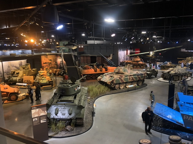
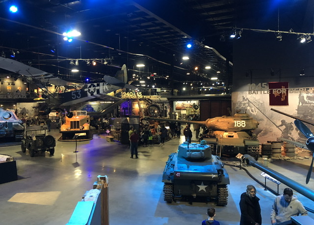
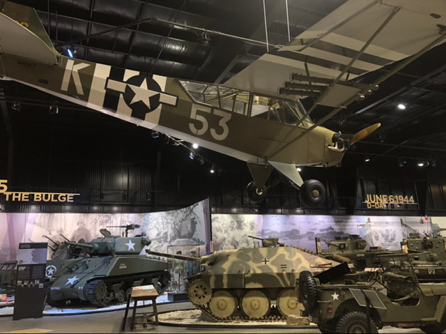
Apparently even bigger in the summer when they open up the other building and do live outdoor demonstrations.
-
I took the kiddo to the American Heritage Museum in Hudson, MA today. What an amazing collection of military vehicles. Mind boggling really, highly recommend if you are a military buff or even mildly interested. It's relatively new and all cultivated from a private collection. Incredible and under the radar, there were maybe 40-50 other people there.
-
Mmmm, give me the IV drip.
-
Fully overcast in Greenfield now.
-
Isn’t that where the ICON went also?
-
14.25”
-
You must have more than that or are you counting since you moved there?
-
If we get a couple tomorrow I will be a few inches below 1/3 total season average.
-
It’s tough because there have been and are a number of chances but still need everything to break right.
-
Yeah, I had at least quarter inch on the driveway at the peak and then it just evaporated 15 minutes after it ended.
-
Crazy that your area is generally the jackpot zone no matter what the set up is.


