Typhoon Tip
-
Posts
43,577 -
Joined
-
Last visited
Content Type
Profiles
Blogs
Forums
American Weather
Media Demo
Store
Gallery
Everything posted by Typhoon Tip
-
Active mid December with multiple event potential
Typhoon Tip replied to Typhoon Tip's topic in New England
See… the GFS has a speed bias. It’s subtle but real. But a model that carries on with that sort of tendency would see this kind of shredding scenario at least excuse to do so - put it this way ...it’s like it “enables” its bias? I think so and I think that’s why it’s almost unable to slow that down. But we’re seeing as we’re getting closer now 60 hours out a subtle improvement; I think we’re going to see that more so going forward clicks towards the euro. I don’t know if it’s gonna go all the way to the NAM or anything like that crazy but - -
Active mid December with multiple event potential
Typhoon Tip replied to Typhoon Tip's topic in New England
Yeah GFS has been trying to speed up the rate of decay of the short wave… I’m sure you know this but most models see it as completely absorbed into the flow and losing identity all together by 48 hours leaving New England ... it’s just the GFS wants to do it right away with instant gratification-LOL -
Active mid December with multiple event potential
Typhoon Tip replied to Typhoon Tip's topic in New England
This has always been precarious… I mean that’s a foregone conclusion and built in. I’m curious what Chris ( Occeanwx. ) thinks… He mentioned this 0 z cycle as crucially losing sensitivity issues related with being fully on board for the full cycles and shedding the old signals out ...remember we only need to flip a degree or two polarword and everybody gets cashed in. A goodly bit of the storms morphology has always had the look of dependency on I ts own in situ mechanics as described and discussed at length yesterday -
Active mid December with multiple event potential
Typhoon Tip replied to Typhoon Tip's topic in New England
60105968913 15318 130430 32999395 That is NAM gridded data for Logan... ~ 10” in 6 hrs in sustained 30 kt wind at 29F Looks like 2” in the intervals right before that ... That’s as far out as the grid goes ... 60 hrs. Prolly significant more looking synoptically at the interval after ..Guessing another 4-6” by the look of it. Jesus. 12 hrs of mood flakes after. Maybe longer. Wow region transforms into deep winter -
Active mid December with multiple event potential
Typhoon Tip replied to Typhoon Tip's topic in New England
Too bad the skill isn't so hot ...because the NAVGEM at 18z trended boldly toward pan-dimensional CCB ... Capital district, to NYC to PVD to PWD to CON ...SE VT ... whole region... 8+ suggestion. And another thing that occurs to me.. .this is going to generate 25 mph gusts .. may 32 in the interior, and probably 40 at the hill tops, and coastal plain ...and if snows even an inch an hour in this profile we may have a blowing/exaggerate visibility issue -
Active mid December with multiple event potential
Typhoon Tip replied to Typhoon Tip's topic in New England
My whole thing is I feel like I'm acting in double-standard if I continue to condone bigger snow amounts... My biggest contention was the data assimilation issue but that seems atoned for now more completely and ... much to chagrins it really hasn't mattered to the GFS and in fact, the other models are trying to collapse toward it - That's not refutable... Having said that, the only thing that holds out for me is that the wind max at 500 mb is running right up and over the edge of that polar/arctic air mass vertical slope and that's likely to draw a pretty significant up glide flow of air into it, because the restoring mass cannot come from the cold side as easily - path of least resistance... warm/theta-e air climbs the slope and that's pretty much why you see the deep navy blue band in the models that have more in the way of impact - I mean there's a logic to those solutions that I think the GFS could be missing here... As far as the other guidance collapsing ..that can be explained by the dampening of the over all wave ... causing a weaker low which would mean S track...fine as a correction considering the dampening motif is sort of late to the part the last day .. day and half of runs. Be that as it may, all models including the GFS run a 70 kt 500 mb jet core right over the polar dome and that simply has to cause isentropic lift and a snow burst I think - What a cluster f!!!!! god damn I'll be glad when this headache over and we "get to" start worrying about this one ...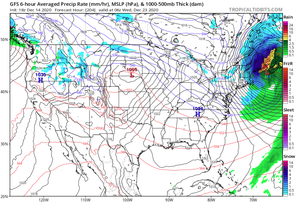
-
Active mid December with multiple event potential
Typhoon Tip replied to Typhoon Tip's topic in New England
This whole thing is almost like a warm frontal wave.. . The QPF "walling" front load look is classic for isentropic burst, and then the CCB is weak sauce, ...followed by storm evac with almost nill backside CAA ... Thicknesses are higher behind the system than at onset - but ...still low enough that should the lagging trough and wind maxima passing underneath need-require easterly anomalies .... blah blah ongoing under-the-radar grits and flurries perhaps... -
Active mid December with multiple event potential
Typhoon Tip replied to Typhoon Tip's topic in New England
heh...not sure what you're after with this question - but I was saying I sucked relative to the countable competition ? - whatever -
Active mid December with multiple event potential
Typhoon Tip replied to Typhoon Tip's topic in New England
I may swing by there in a moment of curiosity .. but, the appeal of the game has become passe' I was dormitory champ in college ... as I had a life - clearly ... But that was like a Japanese fighting fish in the tank full of guppies... I wasn't "that" good, not really. My precog was maybe 5 or 7 moves on a good day, which was enough for that setting. I did okay online at speed chess .. but I think I capped my skill and wasn't exactly polymathic with the board and to really be a name in that world you gotta be one of those cats that walks up and down a panel of active games taking turns kicking assess of throngs of people simultaneously ... I never lost to "fool's mate" but never bothered to learn many openings..I just always did well with king or queen's pawn then night to bishop two ...and wait for the aggression of the other side to expose and oops and commence chopping them apart. -
Active mid December with multiple event potential
Typhoon Tip replied to Typhoon Tip's topic in New England
No way! -
Active mid December with multiple event potential
Typhoon Tip replied to Typhoon Tip's topic in New England
I really, really liked that "Queen's Gambit" on Netflix - well written .. I guess it was based upon an actual novel/period piece from the mid century last. The producers/directors did an uncannyingly superb job at shining on that era's decorum thru cinema - you could almost smell the carpeting and old ashtray odors in the gaudy art-deco 1960s lobby's - ya know? And the costuming and acting was sooo on point for like 1966 hubris mixed with that fake politeness from that era of America - And the chess was fun!!! My close friend and I used to hang out on Game Colony . com back in the day... Jesus that's like 18 years ago now - my god. But we were still young-ish then and would play speed chess through beer goggles until 2 .. 3 am sometimes... We always played our best game right at 3 beers... Her thing in the show was tranq's. Something about passing through that phase of inebriation ... it dulled distracting clutter from the mind, but was just before the synapses gapped too largely hahaha... Man ... we got to 2,800 hundred once with my guy, "TakeMyPoints" - it was a great way to ensure games. You'd open a room and wait ... and some 1800 Kasporavian wannabe cloaking narcissist would happen by and take the bate every time. Zomb! We ended up taking his/her points most of the time... One time ( at band camp!) the person was threatening to go to the site admins because we falsely named our selves - man, ...the idiocy you get on those sites ... beautiful - -
Active mid December with multiple event potential
Typhoon Tip replied to Typhoon Tip's topic in New England
Yeah.. more than less - sorry ..I don't mean to be priggish I just have years of internet experience and typically more the 2 back and forths for some reason results in an hour you desperatately wish you could have back - lol... It's not that I went to x y z... I happen to be right - period wave interference is a real phenomenon in fluid mechanics and when you introduce a new wave to a system of dynamics ..it changes it intrinsically - it has nothing to do with me being arrogant or having gone to Brown... I am actually humble and agreeable much of the time.. but I don't like to yield to fake news - hahaha... kidding a little -
Active mid December with multiple event potential
Typhoon Tip replied to Typhoon Tip's topic in New England
I was just looking over the UKMET and the Euro from 72 hours out to the end of their respective runs... It's funny - it reminds me how sometimes a line of awesome thunderstorms in the summer seems like it can't miss ... then, the outflow out paces the initial axis ... and triggers a new line just to your east, and the original line then starves ... you get shit - the na na na-na effect We'll probably do okay and get something for someone somewhere out of this.. .whether it's just the NYC subforum or up our way ...whatever, but, that wave careening into the MV goes out into the region S of NS long after our system has been completely negatively destroyed from the flow, and then it generates a new storm too far E to even get NS ... It's like a metaphor for thunderstorm line robbing - -
Active mid December with multiple event potential
Typhoon Tip replied to Typhoon Tip's topic in New England
the cyclone we see IS a response to the jet mechanics associated with the S/W - what you say has no logic or Meteorological/physical understanding ( then..). those jets in question are different because of the interference - so yeah..in fact, it IS causing the GFS handling the cyclone - the cyclone isn't coming from nothing - ..it's there BECAUSE of the GFS fields in the GFS - sorry... I can see this is going to aggravate you and I'll step out now ... I'll just say, you need to bone up how cyclones develop and why. What you said, bold is precisely and exactly wrong - -
Active mid December with multiple event potential
Typhoon Tip replied to Typhoon Tip's topic in New England
Not sure what you mean - what is? The lead wave nearing the upper MA there is not nearly the same size and presentation as it was days ago, and that's the point - the following wave over the MV is shortening the wave lengths and compressing the field and is a detriment and is negatively interfering - same interference pattern... may vary in details, the the essence is still the same. -
Active mid December with multiple event potential
Typhoon Tip replied to Typhoon Tip's topic in New England
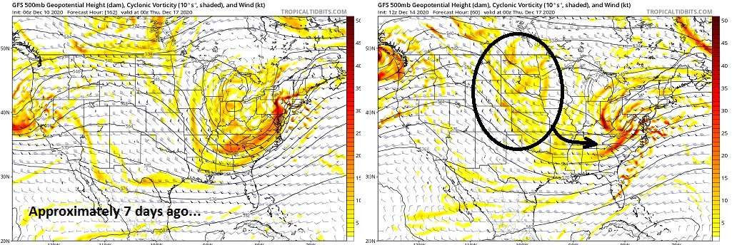
Here...I'll help elucidate the point ... both really, yours and my previous re the higher degree of morphology of flow structures in these Neptunian patterns... Here is the present 12z, 60-hour GFS' 500 mb set up ... courtesy of Tropical Tidbits compared to 'Prev' going back 12 or 14 some odd clicks... note these difference back then, to what has emerged since and is being modeled on this 12z version for that particular time - pretty clear what's f*ed this up for us good and proper: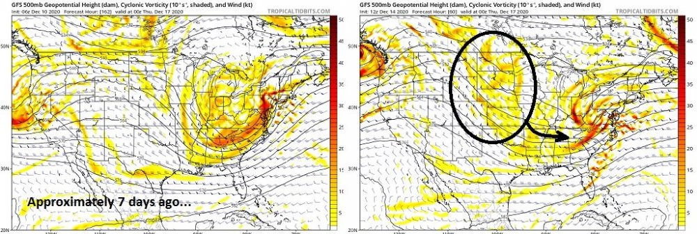
-
Active mid December with multiple event potential
Typhoon Tip replied to Typhoon Tip's topic in New England
For anthropomorphic kicks and giggles ... ... in a way it would be poetic justice in the event of a GFS coup - We spent the better part of a month recently, clearly in outcry over the apparent decay in dependability of the operational Euro model.. How it 'just wasn't the same anymore' this, or it's been 'wretched' that ... I admit, I engaged in some of that myself. In fact I still argue it wasn't very good in the tropics by actual proven empirical data/verification .. Even in this thread, when the GFS was huge the other day, wasn't the Euro less leading that run? If we go back, I'm pretty sure that huge GFS solution ...what was that 7.. 8 cycles ago now, it had like 25" inches in the interior. Yeah, Saturday's 18z ...etc..etc... I think the Euro was less and I recall some posters ridiculing the Euro in that same mantra... There's always hyperbole - yes yes ...of course. But, there was more than than mere expression a month ago when/where there was palpable deriding in a culture of doubt over the Euro ... So now, we sans the GFS in outcry ...and have to eat shit and accept a the Euro because it has more - "while" the Euro ticks S... ho man - that's delicious -
Active mid December with multiple event potential
Typhoon Tip replied to Typhoon Tip's topic in New England
Know what'd be somethin' ? What if this thing ends up actually low end/Advisory ... and while licking prognostic wounds and dodging the usual assortment of subversive sour-grape motivated trolling practices... people are distracted from seeing the next wave becoming substantive. That latter wave is quite coherently interfering badly with this thing and has been getting more so annoying in that regard.. Maybe as it comes in to the Br. Col coast, 'magine if it ends up coming in hugely powerful...? Shit..probably what happens is this wave ends up 4-6" ( not bad - won't complain...) but it'll sweep the testosterone seaward so the next one just wants to go to sleep... And we get one of those "Miller D" - dry Nor'easters ... otherwise known as "coastal Dunce storm" ... 980 mb 70 naut Mi SE ACK with flurries all around it ... You know, that ICON model does show another cyclogen over the ocean between Hatteras and Bermuda toward Friday because of this, which is a correction toward more of that... See, jokes aside ..this fast progressive stuff is also highly mutable and you can get these morphologies seemingly out of nowhere - hence the lower deterministic value when one is suffering this pattern. The whole week still could be a work in progress.. I'm not predicting anything just sayn' -
Active mid December with multiple event potential
Typhoon Tip replied to Typhoon Tip's topic in New England
I keep hitting this phrase in my internal monologue - 'it's a race' It really is... I mean, the GFS is right - if perhaps 'too fast'. This thing is pancaking ... en route to being squashed out of existence by a "failed 50/50's ability to back slow the flow" - don't get me started on that NAO's typical absentee fatherhood on this mo' fugga ... I'm partial to blame too - haha... Anyway, hey, ...least I said there was a possibility on page 1,000,000... ( about a billion pages ago...) that it was possible the progression wins and well... too early to completely rule it out but you're odds are fleeting at best for slower solution to happen... Anyway, it's really again a matter of rate of decay versus does this have mechanics enough to still get the deed done as the wave's swan song? I think the GFS is too fast - owing to it's speedy progressive nature ( anyway..) it's sort of like getting to that shearing aspect too quickly - .. .On the other hand, I could see the UKMET being too conserved the other way. Course of least regret? (GFS + UMKET)/2 * cosmological constant of electron double-split uncertainty principle = X -
Active mid December with multiple event potential
Typhoon Tip replied to Typhoon Tip's topic in New England
Mm. Ya know ... people who engage in this distraction are really after the cinema the weather charts offer; and there is a story and thematic arc there, just like any story that gets told… And it takes a good deal of one’s imagination hence “design“ to turn those pages. In a sense I think most of the people that are hobbyists and Meteorologists .. are all like designers – or at least carry that trait in common… -
Active mid December with multiple event potential
Typhoon Tip replied to Typhoon Tip's topic in New England
Just another perspective ..but fwiw, here's my bullet point analysis: * the total tropospheric wave space is deamplifying as it is moving thru.. * the GFS is uniquely qualified to snif this sort of phenomenon ..because it carry's on with a bit of progressive ( sort of ..)/ speed shearing bias, anyway... Therein, it may rush the delta(dampening)/dt process. * the NAM ( using that as a dipole scenario... ), tends to carry on with a longer term NW bias and amplitude tendency - it may be it's non-hydrostatic/ in situ pseudo adiabatic management offering nuanced additional latent heat feeds into roll out ridges... blah blah...That forces backward and it curls more NW with no compunctions in achieving majestic storm intensity whle doing so, viola! Storm blossome 20" totals in a "very realistic" 4 hour span ... * I think a compromise may be in order. * As an ongoing 'reasonable'/consistently useful deterministic method: when one or the other major player guidance types does not budge, most of the ends results in those cases end up exhibiting vestiges ( more and less) of why that guidance did not budge... that's code for watch - the GFS won't be "completely" wrong here. And the fact of the matter is...it's not already ? * It's not - the hemisphere suffers from speed surplus in a progressive pattern which ( oddly enough ) ( as an aside...that garland of progressive rip is winding around underneath - at least as far as the GEFs have it - a strong negative AO phase ... Hmm, the two are in contention. It's interesting... ) ... So, anyway, for now I think there is enough evidence not to auto-toss the GFS when trying to be objective here. I would also question big totals...while not discounting the idea of a more significant impact, because there is till some uncertainty in the 'sensitivity' of the system morphology due to what is still presently relaying off the Pacific out west into the trough. -
Active mid December with multiple event potential
Typhoon Tip replied to Typhoon Tip's topic in New England
I don't know ... is there an official metrical sort of definition to event minor vs moderate vs major event ? I remember in the 1980s into the mid 1990s.. .back in TWC days of "weather cinema monopoly" ... and even the local TV weather personalities would refer to minor events at 2-4" .. .moderate as 4-6" and anything > 6 was major... Now, seems that's hugely contingent upon conditioning of culture/society ...sociologically adaptive - long words for the fact that we hand out 10" snow bombs like Pez candies since 2000 so ... Maybe that scale - subjective or not ... -- needs to be redressed. Haha... I think a "new scale" that is acclimated and more relative to modernity at present, might be anything 3" has to be achieved before entrance into the minor lounge. Say 3-5" is a minor event... 6-10" is a moderate event... and > 10 is major. It's not just snow board climate and acclimation, either... Tech in snow removal and maintenance makes those lower values sort of outmoded - so there's a practical angle on this too. I have seen 14" of snow between 1am and 2 pm more than just a couple of times since 2000, and was able to drive around on fairly communicable roadways ... and other traffic day in the lifing it - -
Active mid December with multiple event potential
Typhoon Tip replied to Typhoon Tip's topic in New England
Yup! - boom I can see you and et al were on to this facet overnight so no need to get into large vs smaller scale destructive interference sermons, ... but as I was cursory evaluating the guidance, overnight ... ..As far as this social media/public depot goes...there has been a tendency to ignore and/or not consider either way, exactly "why" the GFS was doing what it has been ...In lieu of chasing turns of phrase that protect the heavier snow chances and/or chastising it for being less entertaining - Lol... There was a nuanced ...I wouldn't call it 'nod' so much as a 'hm...' behind pursed lips look over at the GFS by the other guidance... That ICON ( which I still am uneasy and lack personal confidence in using due to ( lack of experience + it's C- handling on the last ...)/2 ) , really tried pretty hard to show the wave damping that the GFS has been insisting, as being more neggie interfering.. In fact, both runs now dampen our beloved S/W spacing to nothing S of Maritimes - someone post yesterday some excerpt taking from somewhere else .. how this was a scenario where the whole structure was "...increasing in strength so that is why the GFS was wrong" ...uh no.. Even the Euro was normalizing that wave down leaving...I think there's a lot of invention of plausibility and that we suffer fake news in here just that same ... Lol again... Anyway, all guidance at this point have a goodly mass of isohypses impinging/bullying into the backside, back through the mid lat's of Apallachia ... into Thursday and even Friday. You know...if that gets a bit more ( and several GEFs members are already flagging this ...), we end up with some kind of 800 to 700 mb easterly jet that stays sort of in position post this thing's eject seaward. Even if weak sauce, it's doing so in a saturated or near saturable column... Could be good for a band or two or broken patches of on-going Currier&Ives holiday parade detritus ... I disagree with the Euro and GGEM that the pattern goes banal and uninspired afterword. It seems the model battle is really that these two higher resolution Global numerical solutions are consummately attempting to offset the sped up Hemisphere anywhere beyond 4 days... I think the 4-D variable system/smoothing is a brilliant concept but it's outmoded in a hurried environment that is proving even chanllenging to the teleconnector statistics - the wave spacing is adaptive to the faster flows and it's sort of taking relative EPO and NAO and PNA mode derivatives ...and allowing wrong weather to happen relative to each... I'm definitely seeing some weirdness in the tele signal --> verification tendencies as not behaving quite as tight and cuddly as decades ago... One reason for that is that the faster flow doesn't appear to allow, or situate patterns for long enough - the residences are moving on... and, lengthening R-waves cause them to "split" which also disrupts the mass continuity ...leading to unusual statistics... But I'm pretty sure you've stopped reading this by now so ...sorry -.. I only mention it because this thread technically did mention something could be in play late next weekend - Anyway, for those that are still reading, the short is that the GFS is probably not as off as it was meme'd to be over the last 30 hours since that one juggernaut solution the other day - when attitudes toward it were "surprisingly better" - gee... I suspect the compromise is in order, until this immediate 12z run ...18z, and 00z are absorbed into the processing - there is still wind momentum in the mid troposphere feeding off the Pacific ...so just because the trough isohypsotic nadir is nearing Vegas, it's still getting fire hosed into the backside...and probably safest course of least embarrassment regret until more of that is actually sampled... Hell, for all we know, ...the 12z runs suddenly help enthusiast - ... I almost/also wonder if the wave mechanics causing that sag Thu/Fri lag ...might also be over assimilated? In same vein ...it could prove under assimilated... and then we got a problem... -
Active mid December with multiple event potential
Typhoon Tip replied to Typhoon Tip's topic in New England
? ...uh, no - -
Active mid December with multiple event potential
Typhoon Tip replied to Typhoon Tip's topic in New England
Yeah I’m not feeling that either frankly I’m thinking 6 to 10 for now ... lollipop for teens under impossible to predict meso axis’. Option for a more robust when the relay continues to succeed and I don’t think these meso versions going so significant here as the relay gets started is mere coincidence. You know the northside ens/model smear usually does not end well for S outliers. Just Sayin. ...If the relay comes in weak sauce then the GFS gets lucky for lack of better word.