

Typhoon Tip
-
Posts
43,481 -
Joined
-
Last visited
Content Type
Profiles
Blogs
Forums
American Weather
Media Demo
Store
Gallery
Everything posted by Typhoon Tip
-
Yeah..it's been doing that with the last several cycles, that handling downstream/ N Atlantic ... I mentioned it to Will earlier - . You know, there is a climatology on Lakes cutters preceding transient NAO blocks over the D. Straight ..which makes sense as any vertically stacked bomb heading toward James Bay will tend to wrap a planetary wave decay into those higher latitudes up there... viola! Heights blossom for at least a while until it all disperses. But in this case, the GFS is trying to establish an actual R-wave redistribution out of it. Not sure - ... could be that it's just magnifying that - it's like the physics are the edge of the visible plain makes the moon look scary huge coming over the horizon - somethin' like that...we'll see. The GEFs do not represent that NAO handling in their mean/tele's last night or the previous night. Now, ...doesn't mean this isn't going to happen. Sometimes the higher res/normalized versions will precede the ensemble mean ... and then the latter catches on. It's a phenomenon more likely witnessed when there is cross-guidance, operational agreement. The ensemble means et al then gather around the operational consensus ...sort of in reverse order. I don't have any idea what the Euro and GGEM and UKMET are doing with the NAO domain, tho...
-
Don't get me started again ...
-
Yeah, I added that right after/edited - had forgotten 2002 ..
-
A bit of preoccupation for XMas when there's other things in the foreground to consider - I don't think it's even snow on the ground for those grousing - it's really about 'feeling' sad about anything that doesn't resemble a Curry&Ives setting out of window for Wassailers on Xmas eve, 'nogs and hot totties and cinnabuns on Xmas morning ... just has to have snow globe aggregates and icicles. Like those scenes in "Funny Farm", with Chevy Chase and Madolyn Smith ... Firstly, that's about 5% yearly return rate on that when considering the 30-yr climate aggregate... Out of the last 20 years, 1 Xmas timed that... 2017.. when we registered 6"10" and not even ubiquitously - I think it was too warm for that in Boston and SE zones... Maybe 2002 - I dunno I wonder why/how folks became so conditioned to where they feel sort of 'cheated' or 'violated' if/when the Rockwell setting fails to set in due timing... 2/3rds of all Xmas' I've lived through in my tenure on the planet at this latitude, between the Great Lakes and New England ...failed to put snow in the air, and on the ground with 27 F rosy cheeked Wassail weather. Interesting... In fact, it's actually cheating the Dr. Dew types to go the other way - NAM's pretty bad as a guidance - to put it droll - beyond 36 hours ... we all know that - but, it's ending frames did tend the mid levels toward a steeper correction for the 22nd. Again... cannot stress enough, ..these flat fast flows off the Pacific ...when the underlying PNA is +.25 and trying to rise... tends to later corrections, and we're seeing this in the Euro through 18z yesterday/overnight ...I think these next 24 hours in particular are an interval to watch as we are nosing these waves off the Pac and into the denser physically realized sondes
-
Yeah, I was a bit nonplussed that they'd pull the trigger on a new technology solution during that storm yesterday ... that's an odd operations call if you ask me. I haven't delved into that new product, but I don't like it for PC so far... We'll see when the weather turns active again how it performs. I don't know if perhaps that is intended to be easier/boot-strap -able for remote tech. It's clear the technology is increasingly adaptive to a phone and portable -device world. It may be the case,.. I am noticing that as these new variance GUIs emerge, their compatibility with PCs .. you can tell there is a silent incompatibility ... The usage is quirky if not awkward ...sometimes lags and gaps in web-based rendering... etc... We're going to bottle neck technology and humanity intelligentsia I'm afraid along with it... such that when the Carrington Event strikes, it makes sure it is whole scale, swift and particularly holocaustic - ...
-
I'm not even finger's crossed for that ... More like considering that as a real correcting need. I've stated my case a few pages ago/yesterday - quickly again... the longer term atmospheric tendency toward progression and speed, does not lend to a slowing down, full-latitude continental breadth, curved flow structures - That's the base-line contention. Yeah, I guess ... persistence is like the Law - it doesn't work in extreme situations. That's code for admitting it could still happen - saying correction possibility means the meridional amplitude variation is still on the table. Beyond that.. .there are other clues, like ..the PNA from the GEFs is neutral-positive, not positive. That's a subtlety in the interpretive usage that also does not really support huge N/S curvilinear loading. The signal there is to maintains a west to east correction tendency ( or vector ). You know... we put down a band of historic snow yesterday, but the important and (perhaps scary if we wan't to get into it) one is, pun on purpose, 'under the radar'. 30+ " of snow over that vast an area was verified in 12 hours! It is not just the d(Q)/dt, it is the * mass! That's got to be some kind silent record, if not damn close. Lot of storms of lore and yore put down hip height snow, but to do so at that speed and short duration ...over the state of Nebraska.. That said ?? We're not getting out of a warm sector...It's a matter of weather it's rotted polar air that is of the 52/38 variety, or as you say 54/53 S windy white noise through barren tree tops in strata streeted misty rains... I give it 50/50 shot of either version. I don't think said persistence is related to the pattern in situ, as it has been a multi-modal, multi-seasonal/decadal thing at this point... It's persisted through Ninas and Ninos and -AO and +AOs and EPOs of both ilk and NAO too... and is caused by a separate issue altogether - but don't have to broach what that is, just knowing that it's likely to at least factor, probably should give an extra consideration to persistence in this case. As a quick afterthought ... one could wonder fairly if a bigger meridian structured ordeal would also just gestate in and out of existence quicker, too - ultimately limiting the time spend in the car wash - How about the extended GFS though - man...that 00z guidance loaded the last 7 days of that run with sweet pulsing -3 SD west base NAO ...that's the way you want NAO, pulsing!
-
that’s likely good enough with marginality working with sufficient dynamics but are the 500 Millo bar charts available for that?
-
It is ... but it was similar to the 06z GFS it’s not like it’s unprecedented over recent guidance cycles And recent pattern behavior, and other signals suggest that should watched. Just sucks because we’re in this flat P nap neutral positive PNA that’s really fast so really subtle nuanced variances in the momentum coming off the PAC can mean a quick hitting thing or nothing at all blah blah
-
We do ? we've been talking about it for days ... I know I know..
-
Or is right at the threshold and can't get any more indicative or it has to - it's really right on the edge --.. I'd say if we can grab a hold of those isopses leaving the MA out over the open Atlantic and get 'em into 'bent' configuration (while of course conserving the appeal of those two precarious phasers- even a little on the next run ) we're probably headed for something
-
Ok, ...wee bit embarrassed - where are y'all seeing the 18z Euro ?
-
Yeah...I fear coming off as an optimism bunny lately but unfortunately ...we are in a mode where that sort of look is not really fitting with the longer term/persistent progressive nature to the hemisphere. That fast nature is both multi modal but also multi seasonal and goes back systemically for years at this point.. I don't "think" it yields just in time to allow that deep full latitude curvi-linear flow structure that moves the N-S length of the continental middle latitudes ... But, anomalies nested inside anomalies ... do take place from time to time. That just means... fast flow, then it slows for transiently, the back to fast flow - that transient slow down becomes an anomaly relative to the longer termed signal ... Sparing a long sermon - it I think a flatter variation of that is favored by said persistence and also.. the because implicit teleconnector, PNA, is neutral positive from the GEFs... Haven't seen the EPS PNA derivatives but (GEFs PNA + said persistence)/2 = something less dramatically deep and wound up ... We could cut, but it would be a flatter trajectory and not likely foisting a misty DP anomaly and southerly gale with it... More likely sharp c-fropa type ... I would look for that as the more plausible correction for now. However, before even getting there ... if the 22nd (~) system were to get more intriguing it's probably have a transitive influence on whatever happens next ..so, it's all fluid at that moment.
-
The EPS was 3 to 5 dec deeper with the 120 hour axis nearing the MA Tuesday and a tick more aggressive with a GOM surface response- ... Very fast flow and we are not sampling all the material players over the open Pac quite ideally just yet.. But will be in cycles over the next 36 hours, particularly into Saturday... 22nd may be a late correction owing to these wave spaces ejecting off the Pac inside of a only 2,K naut mi width of mid latitude degrees at unusual pacing .. traversing the country at ludicrous speeds.. This is a candidate to do a three cycle correction abruptly toward a neg tilted but open, quick cyclogen ... NJ model lowl... Or, we could wavering flatter by the night runs Saturday into Sunday. For now as Will mentioned, we are sort of wondering about the S stream as a seeder wave serving to place hold/time right with that N/stream fisting southeast out of the Lakes to maybe subsume. But, it's also possible that just like this wave in the MV today, that served as today's 'kicker'/damper, also started calving backward a bit against the flow and digging ...the N/stream may follow the same behavior. It's already a potent jet... Then we don't need to phase/subsume as much because the N stream my yank the atmosphere around on it's own as a correction too - Lot can modulate between now and Sunday's runs -
-
Yeah, too bad that is: - the JMA - any model at 192 hours ... but, I will say... the Euro, GGEM, and this above? They are in tolerance distance for 'agreement' considering the extended. Just for fun though, if this had a 216 hour panel, that would probably be a 957 mb low E of NJ. That is absolute hyper perfect subsume scenario, with that arctic polar jet just dangling precariously while the southern stream plays tag with it.
-
Thing is, I agree with what Will hinted, as a general theme in/and/of awareness over the planetary hemisphere - the flow doesn't really support those uber N-S ( meridian) looks. It goes against the persistence canvas, which favors less Y and more X coordinate stretching. It's not to say things can't relax. Anomalies relative to on-going anomalies, nested ..etc.. I just think the "correction vector" - or where to look for the correction tendencies if you will, that should be pointed toward less full-latitude phasing - certainly not so early in the continent. This sort logic worked for the system prior to this one, even if it was a dynamics bust - or maybe it was the one before that ? either way, those were originally destined to Chicago and neither really went that far west..
-
Hmm ..funny you mentioned this - I was just gonna pop off a paragraph about how the GGEM looks like a staggard progression of the Euro's tastiness there - There could certainly be some 'useful speculation' above the background noise to watch for ... I agree, 22nd-ish ... albeit a long shot but interesting trends, and we'll wait to see what Saturday's relay off the Pacific does ( or doesn't ) for that... But the latter event "might" just have a bit of Archembualtian vibe to it - I almost wonder if we'll see this subtle +PNA handling at CPC continue to emerge over the next few days, because sometimes the deterministic solution will hint prior to the ensembles - it's rare but sometimes...
-
That end frame on the Euro is a prelude to something interesting on the EC... With the obvious caveat emptor in stride that we have almost no hope of that setting up that way ( lol ..), notice the heights over Florida are both less than 582, and there are larger distances opening up in the isohypses between Texas and S of Bermuda... The flow is very compressible there, and we see a lot of ejected mid stream PV gunk about ready to potentially phase with that seeder southern streamer in S TX, ...I bet that whole business would be fun -
-
Adding to Will's Euro ... ...that D6 is different now too.. It's showing less in the way of full-latitude N/Stream dominance resulting in a Buffalo route ... That's a "quasi" 50/50 there too - if transitive actually, if that upper MW wave were a tad weaker that would be better, because in that notion it likely rolls more E and probably does an NJ model job on the upper MA/NE regions... extrapolating - we'll see how the D7 --> makes me a liar, but this D6 doesn't strike me as a total loss in that time range ...
-
yeah...no sense getting into a huge re-iterative babble ...but here we go again. This is all coming off the Pac regardless of model at a low curvature, high speed amplitude pattern... which is code for not being really in the wheel-house set up for any guidance. Sampling/assimilation "almost" screwed the pooch on today's system, but we managed to hold the wave mechanics long enough to get (... fascinatingly) an isolated historic result out of seemingly less - very interesting actually.. Anyway, we'll be relaying Saturday for next Tuesday's shenanigans ... plenty of time to bring this into emergence and then f-it all up lol
-
We're hoping she doesn't... Sorry I don't/didn't mean to just interject that and turn this into another pandemic diversion ... man, I'm sure I share in this desire to see this just be accepted into the cultural pathways so we can cultivate new drama from new headlines ( yes...that's sardonic, but we are "sick" of this damn thing, with all due puns intended...) Yeah, no - like many aging Boomers ...they didn't live their lives with the life-style advantages we have... We don't just benefit from nutritional availability, we have science and know-how about what not to do. My f'n parents smoked for like 30 years...and ate confection isolated sweetened beverages and cherry pies, because they were proud of mid century main-stay provisions to the masses their generation put together so that those of us alive today could benefit from their mistakes as we witness their elderly decay - it's sad... They enjoyed there lives the best they could.. and now, we put our parent in the Earth for all kinds of varied reasons, ...not just the "pandimensional hysteria," and sometimes prematurely when comparing/ased on our generation(s)'s life expectancy ... So, she has other underlying pre-existing..blah blah-blah blah blah like so many... + age .. So she starts up with sudden and weird symptoms a week ago and is bed ridden as of yesterday ...and in Michigan, where they are handing out diagnosis like candies from an exploded Pinata ... she can't go to an ER/hospital because that's doom - she's definitely liable to catch it there... So she is in wait of a stressed out medical infrastructure to send a PCP that does in home stops when there are so few left available - f what a cluster f man! Meanwhile...I'm scared shitless of being orphaned for some reason - and I think it's because I'm desperately lonely and ugly and evolution has apparently slated me for discard - heh... not being totally serious...It's just that when one life's gestation goes deeper into with middle age, and they don't have certain needs fulfilled... watching the possible palliative stages of one's parent's lives unfold before them ... really hones what they are missing - especially when their mother's voice is slurring and crackling, when she's asking them, 'have you found a g-friend,' with an ounce of found cheer. you get it -
-
Ho man - what an epic Boxing Day mess in that GGEM cinema - ...and that is coming from a model with a consummate warm boundary layer in that range...
-
GGEM looks pretty sharp at 500 mb around the 22nd too - more so than the 00z ... It's also got a touch of 'Miami rule' look though, having it's PV fields slopping backward across the N gulf that way...
-
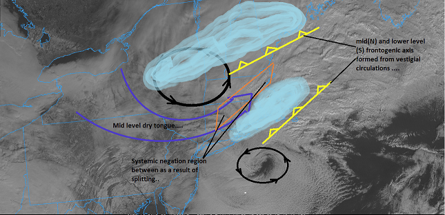
Sorry I haven't circled back on my '20th - 23rd' suggestion from the other day - with this thing and my Mom apparently having the C-19 ( being tested for it...) it's been a bit harrowing ... But, I still think those days are on the table - though perhaps even less obviously so as this one we rejoice in ( or not...), today. The 06z GFS would be snowing over SE sections compensating for warm ptype fetish in cold thickness/and obtuse BL thermal dynamics in falling precipitation - the other aspect with that 50 mb low trajectory other synoptic events cannot really be precluded - Now...having seen much other guidance, but the CPC PNA does show that subtle PNA rising so ... and this all hearkens back to the GEFs individual member suite from five days ago, that showed a more robust presentation over eastern N/A mid latitudes then... 12z seems to carry it too - Thing is, ...we are still in a neutral -positive overall fast flow pattern... Low curvature amplitude, but very amplified in the W-E coordinate alone.. .This is always problematic for timing and placement with this Pac assimilated waves... I mean, this one we're getting today ...was in fact, ultimately victimized by wave-space robbing as the MW ordeal is crowing and kicking it alone, and lift the flow up the E actually limits the today's wave space could have even amplified - it was a late arrival correction to the modeling over three days immediately leading ? if folks recall, and we had to scramble a bit to decide what would happen. The cold rich anomalous arctic air being place, cause today's to split open - I annotated some art work to describe this in the obs thread if anyone's curious... I see this next [admittedly, probably miss, sure ...] as still having some uncertainty where we cannot rule it out entirely as being a clip across the region... The wave mechanics end as another quasi -southern stream, and it is unclear it if gets, damped out, pulled ne into an eventual phase, or left behind... If that were not enough - the N/stream alone is precariously close enough to do an NJ model low type ... Haven't looked at the surface but the 500 mb 12z looks rather "clipper deepening" toward the 23rd.. These mechanics don't get sampled until Saturday's cycling so ... here we go again!
-
Better fall rates have resumed here in Ayer after our run-in with the verified albeit hinted if not wantonly ignored ( hahaha ) gap this morning... I threw this together for those who may feel jaded by this event - sometimes it helps to have the explanation...and I'm sure others may have some analytic ideas to add...
-
I suppose I could have said "Meteorological thesaurus free" ... otherwise, "twitisspheric" culture is doing wonders for the base-line reading/comprehension storm - yeah


