Typhoon Tip
-
Posts
44,568 -
Joined
-
Last visited
Content Type
Profiles
Blogs
Forums
American Weather
Media Demo
Store
Gallery
Everything posted by Typhoon Tip
-
With a last gasp effort, winter 20-21 refuses to give up the ghost
Typhoon Tip replied to moneypitmike's topic in New England
The convective sequencing idea has merit as phenomenon in itself. I'm not entirely sold it is primary in why this event did not snow more above NYC, along ALB to BOS. That region averaged .6 to .9" of rainfall... which is still 70 some-odd percentile of the QPF - however, I would point out that that could be explained without 'convection robbing' For one thing ... convection explosions seed latent heat exhaust downstream. That tends to fix/correct heights higher immediately astride along the right side of the storm tracks. This can cause cyclones to track NW of guidance ... albeit more or less demonstratively so. I mean it can be subtle. But here's the thing ... this was losing cyclogenic kinematics as it was moving E on whole ... devolving into an open baroclinic field. There really was "less or even no cyclone to correct" So perhaps ... if there was no convection at all.. the ANA aspect would have lingered longer ? yeah maybe... But that may be too difficult to parse out anyway. I would also point out that models typically over dose ANA QPF to the surface, too long and much - I wonder ... if there is a standard error ANA, and if this events 'missing' QPF ...I bet it closer to the model bias. -
With a last gasp effort, winter 20-21 refuses to give up the ghost
Typhoon Tip replied to moneypitmike's topic in New England
Giving or taking - -
It actually looks like a locked pattern with multiples going that way. It may not be people’s interest area around here but I’m wondering what that might mean for our convection season as we get closer to May. I think the south east ridge is going to make a presence more often than not this spring is where I’m going with that - I’m inclined to watch around April 1 for a cut off, too. Bowler
-
With a last gasp effort, winter 20-21 refuses to give up the ghost
Typhoon Tip replied to moneypitmike's topic in New England
Okay. You win. I’m all that. -
With a last gasp effort, winter 20-21 refuses to give up the ghost
Typhoon Tip replied to moneypitmike's topic in New England
I did ? ... one has vastly more profound aspirations than seeking credit in that sense, in here. I said "WE" as in the collection of all, specifically to avoid that context interpretation - so.. you clearly have an agenda to read in ( the wrong way..) to get that conclusion. Look, folks should not have gotten their hopes up for this storm - ... your bringing that up sounded a bit like a redirect of your own anguish by finger wagging everyone else, as though we were not listening to that sort of advice. But we did already ... get it? maybe that interpretation was wrong? fine - but that's a typical antic in here, and THAT is vastly more annoying than someone who bothers to write paragraphs. -
I think if it works, ... don't f with it, then... right? I mean, so people are getting in ahead - who cares. If it ain't harming anything, we're closer to herd immunity .. or whatever it is called when it's a combination of self-resolved and vac populous - actually... come to think about it.. .what's the difference ... Anyway, a year ago roughly two weeks before thanks giving I was stricken for a week... 4 to 5 days of which put me through a sequence of symptom progressing that pretty much was identical to the COVID-19 package. But, ...no, it wasn't recognized on the global stage until a month later, mid Dec of 2019 - I can't believe we've really just passed through a whole year of this shit.. Might be the fastest perceived year of my life - weirdest too for other personal reasons. Now, China leakage ... I read somewhere that China is admitting this thing or it's ancestral root was in circulation in the general public much earlier in 2019. Rumor has it ( so it is likely untrue...) that up in Ireland/Isles they are exhuming bodies and finding that C-19 was present in corpse that also succumb to "strange illness" earlier that year. ... As usual ... I'm digressing. My point was going to be, I wonder if some of us had this? I'm < 55 and by western civility standards in ridiculously good shape...so, I'm a likely candidate to self-resolve. I had fever, dry cough, and fatigue and headache... lost of appetite... and my gourmet coffee tasted bland. Other than that ... I actually didn't eat much other than three donuts over the course that week. But it was bad. I was in pools of sweat at night.. wobbling down the stairs in the morning. Couldn't regulate body temp.. Then on D3 the cough got a little wet and lung gurgling kicked in... but it only last 1 day, and both it and the dry cough rather abruptly disappeared by day 5 and by D6 I was out.
-
...A time like this in this particular social-media mise-en-science ... is like attempting to moderated a cat fight dressed in dog costume. Particularly in a sensy motif brought about by a last season mercy snow event that busted - it was like not an exit hurrah at all. It was like the scene in "Airplane," ...where Leslie Neilson's character was trying to cinema-trope slap the hysterical female passenger into calming down, and when asked to step away ... he hesitates, and steps back in to get that one extra slap in - Love that ... hi - larious ... continuing the metaphor, as Leslie fades out the camera then pans down a line of people waiting to take turns on her, boxing gloves, ... baseball bat, even a crescent wrench, samurai sword and guns - that's summer for many. But, this winter is Leslie Neilson, and the hysterics of winter ending with this way is the extra slap being received. LOL
-
With a last gasp effort, winter 20-21 refuses to give up the ghost
Typhoon Tip replied to moneypitmike's topic in New England
I seldom want to get into the grading wrangle but what time I've given to it - I think this year fairly falls below average in grade... less than a C ? My philosophy is more adhering to climate. IF we get at or around average ... that's a C... If we go above average ... etc etc... but, in pure numerology - landing on climate should really be a 100 ...I give in want as a failing...I know - It's a subjective scale of course... people in the public ambit need to have their agenda fullfilled and that's fine. But, if someone needs to get 65" to get a C ...and still reserves the right to grouse and call it grudging... all I can say is, man - glad I never took Calc II under the yolk of that teacher's grading policy. Anyway, I set at 53.5" for the year I believe .. .I think that's 5 less than average if it ends like this - I mean ... I would never on March 18 think it does out of hand in this butt-boned capital of the world. But ...I don't care for snow much going forward, full disclosure so... D+ is what it is if so. Fine - -
With a last gasp effort, winter 20-21 refuses to give up the ghost
Typhoon Tip replied to moneypitmike's topic in New England
Don't read them, then - don't want to cause you any anxiety or undue stress in the matter - lol. jesus - no...your being douchy this Why, was someone abasing/impuging Bouchard ? .. -
Funny... the Euro stalls the 2-m temp 55-59 across the area on Sunday and ... that just does not fit a-priori or existential awareness of what that does at this time of year. It should be mid 60s minimum - and 70 would be nicked over back patios and driveways. I'm willing to nod to lack of mixing being close to the centroid region of the high pressure bubble... and that might not realize the BL being that tall, but even the 925 mb adiabat is 64.. 65 at HFD that afternoon. I think it stops adiabat at 900 mb or something and doesn't render it to the 'real' surface? but then why would that call that the '2-m' ? I dunno -
-
More than less, yup - but, I also add that the increasing, ...at the other end, dimming, that begins to accelerate in either direction on Feb 8 then Aug 8... - adds to it for coinciding an actual empirical physical metric like the actual sun power. On May 8 that acceleration begins to actually slow through June 21 and tho we lose through Aug 8, ...it speeds up markedly then.
-
It always occurs to me ... Dec 21st ithe shortest day of the year.. that's all that is. It happens to be the solstice. Maybe the meaning of winter is misnomer'ed over the course of history. But as a climate distinction, it lapses that date enough in either direction depending on the given year's vagaries of the patterns ... There's nothing really magical other than to say, 'shortest day of the year' - doesn't mean much else. Calendars? Human invention.
-
I've been told by several who've been vaccinated that they were lax at best re any sort of background screening and mostly - they don't really check - It's not like you're being glowered at, "where's you papers..." outside of Stalingrad circa 1939 ... They ambled in and claimed they have a-b c job or x-y or z co morb and it was sit here and get poked - I mean, there's lists sure... criteria for who gets what based upon whatever - but you know, it's a logistical infeasibility to expect every tom dick and suzie marry to provide some kind of proof of ailment passport
-
Jeez ..lol, I mean that's only one legit paragraph otherwise .. a sprinkling of 5 or so sentences - Yeah I know... hey, that took me 5 minutes to type - and no ..in case anyone is wondering, I am not on my phone at a food pavilion in a Mall or waiting on someone curbside for a ride. I work from home and sometimes days are slow - like today... I thought that was funny - ... 'pissed off hornet looking to sting anything in blurry sights' ... made me laugh typing that -
-
With a last gasp effort, winter 20-21 refuses to give up the ghost
Typhoon Tip replied to moneypitmike's topic in New England
We've been talking about too, for several days... Just sayn' -
... seasons change when they do... Kind of an oxymoron to say "..We done" and then suggest a couple more days - which is it ? lol ... I know what you meant though. For me, spring begins on February 8th every year. Winter begins on November 8th ... Why, because I derive pleasure from annoying people... but also, Nov 8 thru Feb 8 is the solar mimimum of the year. That's when the solar insolation power of the sun dish-pans ...even on sunny days ( for example ...) snow packs are resistance at 40 N latitude... Minimum's duration of course is shorter south, and longer N of our latitude and so on and so on.. The max around here is May 8th through August 8th...and that is summer in my crazy world. Everything in between those is spring/autumn, respectively... That's if going by like Math and actual celestial mechanics of astro physics - ... But, we here on Earth as mere mortals have this pesky bias of being drilled into what effects/affects at a sensible level - ...to our senses, climate lag dictates the seasonal changes ...as ultimately directed by what can be felt and is observable, therein. Warm weather returns ... buds swell...confused hornets come out of winter slumber addled and pissed off because they haven't had their morning coffee and set to 'dry stinging' anything in their blurry sights - hate that. But all that usually doesn't really get going until that first April true 4 days of 70 with nighttimes staying well above freezing.. (Usually just before the orchard killer blue urinal cake snow event .... but that's another annoyance altogether )
-
I'm telling ya ... other hobbies haha... Nah, I don't think people were complaining about busted this or that last October when it snowed a legit snow event prior to Halloween by a couple of days. Obviously -...allowing for folks to vent their hyperbole. We get it ... but just sayn' we can't always get what we want in this recenty "invented culture" made possible by internet technology plus forecast modeling/graphical cinema. You know...we've talk about this 'conditionalizing' aspect in the past, but it seems apropos in this moment here. Like, what an amazing stroke of fated timing - that we would see the advent of the internet and the ability, in itself, to formulate that culture as described there, at precisely the same 25 years the climate has gone completely bonkers and have been throwing out +4 SD cold(hot), dry(wet), calm(windy), rain(snow) events like Pez dispensers. I mean, what if we had this ways and means to formulate this internet society of weather cinema enthusiasts ...in a dearth of active climate? I just wonder - would people grouse the same way? I don't think so...because having not been exposed to regular snow threats in October ( ) ... they wouldn't be so quick to negate that experience when constructing any such personal impression ...like not getting fun out of this - in other words, spoiled. Lot of elegant rhetoric ...condensed to one word - But it's not just weather...The whole internet and access to information and "event drama" ...is a saturating high. And looking out the window at actual reality ...? It's unbearable uninspired compared to the drug e-psychotropic realm inside of the manufactured reality of modern tech... But I'm digressing... This in here, what we do ? it's just our version of suffering the same saturation/'over-stimulus' ...and folks not only have trouble putting it down, they start to believe the stimulus is the real 'reality' and stampede the Capitol - in that metaphor, we outrage and mere normalcy
-
With a last gasp effort, winter 20-21 refuses to give up the ghost
Typhoon Tip replied to moneypitmike's topic in New England
It's funny ... I like the use of the word 'synergistic' ... things are sometimes 'favored' to happen - It's like you have a separate 'emergence vector' - it doesn't exist until aspects are put into motion. ...Like we've all been through times where it just seems to always snow; contrasting, it never can. And these will take place despite ongoing indicators, too. Snows with bad teleconnectors ...it just finds a way. Or, like the antithesis... We have been in a +AO mode now for two weeks, with an NAO that is neutral positive, in a flat PNA... in a La Nina spring, and we can't warm up no matter what? Maybe next week will change some of that... "maybe it won't" Anyway, we have been suffering a kind of 'de-evolutionary' tendency in system integrity for the entire cold season... Routinely, features and phenomenon of the D8s and on ... invariably come into mid range as a less impressive system... sometimes then failing to even get to short range before it seems the passage of time itself caused it to minor out - like the models just had a cool idea but got bored and abandoned it... haha. Obviously that's joking but ... this system seems to have done that to us again. Even though it sort of did it later. Check this...I might be wrong, but wanna say back when this system was D7 it wasn't really much of anything then... This did that song and dance of minoring out in shallower time it seems - the NAM lied with its NW bias as usual, and then the Euro thought it would be funny to deliberately f with heads by putting up a couple of agreeing cycles - it was a perfect storm of misdirection LOL. Either way...here we are again, and it seems to parlay negatively - there's some sort of negative synergy going on to 'cancel' these things. Almost like a count-down decay rate going on with all systems: d(cyclone)/dt exceeds actual time, system becomes null before it gets to reality. If that rate is slower than time... use the decay rate to determine what it will be when the time arrives - less. -
With a last gasp effort, winter 20-21 refuses to give up the ghost
Typhoon Tip replied to moneypitmike's topic in New England
Yeah ...there's that too, Scott - add that to the till of bad model handling. All though, convective "robbing" as the euphemism goes, isn't really quite yet in the model skill - I wouldn't think? I mean, talk to us when they know precisely what cumulus cloud will become a cumulonimbus ... maybe at that level of godly prescience ...the models will "see" WV choking and desiccation ... Perhaps the models had a chance to save some face with a 2.4" er ...say, but then their being blind to the 'where' convection and therefore not having any remote clue on how that would in turn modulate matters ... ooph It seems this might be the straw the broke the modeling back - -
Operational Euro seems to have subtly bumped back optimistically for mid, next week... but it may not be enough for coastal zones. Saturday and Sunday still look like gem days - ...late recovery Saturday with longish day, high sun and general synoptic evolution. I mean... relative to what probably those days 'should' be like on March 20 and 21 of any given year - heh. Now that we are within a couple of days of Saturday, the Euro gets cute with details. It is displaying the 21 thru 00z 850 mb temp layout with 'hole-punching' ... +1C islets amid a sea of 0 C... that is happening because of boundary layer cycling ... a nice demo of unabated post Equinoxial sun's intensity forcing the air mass... I have seen it be 58 F over a solid snow pack in late February, with light wind, open sky sun and 0 C at 850 mb. Saturday is a candidate for exceeding MOS .. but it may be a late high. The key there is unabated solar - that high pressure centered White Plains -ish NY and destined to E of CC over those next 48 hours is offering means to mute the ocean cold from pouring inland for one, and it becomes a pure 'nape' and perhaps outright mild. Sunday probably exceeds 70 F in the deeper interior I bet .. Thanks to high pressure, slacked gradient with still open sky and 850s' securely > 0 C... However, folks withing 20 miles of the south and east coast, heh - that high is retreating in a bit of shitty direction frankly. I mean ... it won't be cat pawing at 38 F exactly... but one should expect a gradation of mild appeal ... pretty steeply sloped into pissed of chill in a Euro total evolution. Figure 47 at Logan, and 71 on the lee side of the hills. The ocean/harbor SSTs being seasonally at a nadir any air motion from that source ...see ya. It will abruptly destroy any gossamer March "warm up" ... If future guidance backs off that over produced vortex off the U.S. SE coast ( which looks over baked to me given to the mid levels as an aside ..) then the retreating high may do so ... 100 clicks S; that would stem onshore wind and in fact, may get it more SW ..such that Metrowest isn't as annoyed. I just you can't depart high pressure straight E - as a spring nape/warm enthusiast and avid nerd .. I can honestly say, I hate that. The wind will go perpendicular to the gradient beneath the elevation of the Prudential Tower all the way out to the Worcester Hills when that happens. I've seen it be 45 F at Logan under 588 heights in late May because the high position was due E Boston. Tuesday+ ... forget it... That is like almost bona fide windy out of the SE penetrating the whole region. Partly to mostly sunny and UNpleasantly robbed from the previous signal that looked like we were getting a nice 4 days balm .. Having said that, is is not as bad as it looked for this aspect, as was the case in 12z yesterday so ... perhaps this can trend less annoying. In March in SNE? Nah...
-
With a last gasp effort, winter 20-21 refuses to give up the ghost
Typhoon Tip replied to moneypitmike's topic in New England
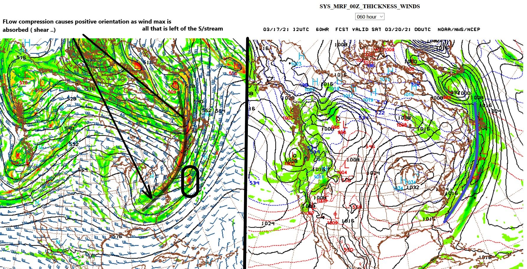
Not trying to rub it in and/or toot horns ( I swear ..) but this was cautioned through both serious content ( and trolling snark - ha...) Seriously tho, it was ....ever since the get go. I won't lie tho - it is/was difficult at times to be aggressively against the models. For one, duh... But, if it were ever so obvious, I probably just wouldn't post - it's hard enough to assess whether people are even reading, if -necessarily- one's contribution happens to be contrarian, conserved if (unfortunately ...) circumstantially uninspired ... to put it nicely. Often that effort appears ignored ... One can get into distinctions .... like whether this is shutting off faster, vs not really shunting south ... but those two are causally interconnected frankly. The problem with this is the term "shunting" - it's really maybe not the best adjective to describe what is taking place. What is really happening is negative or destructive wave interference between the S/stream and the N/stream... This was/had been evidence in the guidance for days actually. I - personally - am not sure why the runs were fighting so hard to overcome those larger synoptic scaffolding problems in trying to build an event that was weakly going to be riveted together ..because of that stream interference scheme; it was there all along, and these latter couple of model cycles - to me - are kind of like 'no shit' to the models. I think it's a bad model performance as the real focus here - by all.. Euro...NAM ... GFS frankly gets a subtle nod because it was flatter - maybe - but I also think that's not because it's physics are superior; it is by ongoing bias convention "too fast" in a fast flow...which sometimes defaults it to looking right - it's very confusing with that thing. As a result, you take the 12z position and cyclone systemic structure, of all guidance 00z run, and then look at it at 30 hours ...then by 48...60 ...across that expanse of time starts out as a classic Norwegian Model low at the front... and at the end, it is a cold front. As was once stated in "Plains, Trains, and Automobiles," ... "You're going the wrong direction!" The whole system response to the negative interference was decay the system to an open baroclinic field, from a closed one... Which is kind of interesting because that is the exact antithesis of the typical behavior for systems approaching and leaving our longitude... Anyway, one can call that 'shunting' but what it really is more precisely is 'deconstructing' cyclonic kinematics ... and so the storm decays into an open wave and then ultimately a residual front. I see these recent model runs that are moving the precip off/ narrowing, faster, as just getting in closer to the limitations in space and time and the storm is seen as weaker, period. But keep in mind... we're talking within the virtual universe created by these guidance tools - these are all distinctions that are relative to that framework. There is still a reality that needs to cooperate -I mean, aspects rear from the unknown and cause 'out of the blue' things to happen from time to time... There's no way to hold the models or interpretation in the best of deterministic/objective approaches very accountable in those weird scenarios. -
With a last gasp effort, winter 20-21 refuses to give up the ghost
Typhoon Tip replied to moneypitmike's topic in New England
Yeah I mentioned earlier that the Nam and the euro were moving together in that regard. That makes it seem more systemic in nature i.e initialization controls. Although I wasn’t aware it was 18 versus 12z or whatever but I guess that makes sense if it is -
With a last gasp effort, winter 20-21 refuses to give up the ghost
Typhoon Tip replied to moneypitmike's topic in New England
I'm not sure I see where the N/stream helps ... it appears to be in negative interference overall... It's not 'phasing' - it's compressing the flow ( negative ) and that is speeding up factor and the wind max/jet structures of the S/stream end up absorbed into it and lose identity. That is way the deeper layer ( 500mb ) evolution shows it sloping back SW positive in rotation like this, The cyclone in OH becomes a cold front SE of Nova Scotia - Contrasting if the N/stream was late arriving assist - that would be stem wound low and not just a cold front escaping across the N Atl.
-
With a last gasp effort, winter 20-21 refuses to give up the ghost
Typhoon Tip replied to moneypitmike's topic in New England
yeah this is another example in why suspending the model initialization arm of operations at NCEP was a brilliant move ... heh, kind of like the dissolution of the pandemic arm of the CDC 15 months prior to needing the pandemic arm of the CDC - ...I mean, that scale and degree of boobery is what drive frustration to the brink of conspiracy belief system - my f'n god -
With a last gasp effort, winter 20-21 refuses to give up the ghost
Typhoon Tip replied to moneypitmike's topic in New England
So ...frankly I am a bit surprised the Euro came in that robust - It is interesting that the Euro and NAM have been sort of yawing NW then back SE ..in tandem across these last last 5 model cycles. That seems to suggest the variance is not so much being attributable to specific model bias' ( although they got them..), but perhaps more so with initialization/data ingest as more likely the culprit. The NAM spent some part of the overnight with nothing - let us not forget that. And the Euro also struggled to hold onto its earlier 12z, 4-6" advisory -type result, too. So, yeah...movement en masse suggest the cause is broadly systemic - That said, this really occurs to me upon deeper reflection .. it just simply comes down to rate of decay of the southern stream as it arrives. Everything I mentioned earlier in the day when I was struggling to troll and failing - I guess they're on to me ...hm - is still true. The total system is attenuating in that regard. But, correctly timing the rate of decay - that's bigger ball of wax; it seems that could be explained by runs getting 'that much' better ( or at least different..) data initialization. The impetus being...strong/> momentum gets the goods further N. The suppression is coming... but that may wait that much longer while a bigger stone rolls by in the stream underneath - metaphor... I don't believe over land is an assimilation issue ... that seems to be more a sensitivity that arises from whether small pixels of wind max are missing or sampled -