

Typhoon Tip
-
Posts
44,568 -
Joined
-
Last visited
Content Type
Profiles
Blogs
Forums
American Weather
Media Demo
Store
Gallery
Everything posted by Typhoon Tip
-
Yeah, I don't know if the 'huge' will verify ... but, this looked to me like a late-ish correction candidate, all along ... toward less y-coordinate depth ( amplitude in terms of trough depth ), which then would open the possibility of more of an easterly fix in short terms, but also less snow where it snows ( terrain enhancing, notwithstanding ..) I mentioned this the yesterday or the day before and here we are... I suspect the other guidance bumps east and also reduces snow totals from those lofty 12-15" typically inflated snow products. They're just too 10:1 without any situational awareness built into them - they don't modulate for anything other than some very basic input metrics ..blah blah... but since no storm has just those baser aspect in play, those products 'll never be more than 40 to 70%tile to me. But ...hey, 70% is pretty good when scores that high - so... for that, we can justify ogling 30" layouts and dream through a long exhale. lol Anyway, I see the NAM may be overdoing things...but, should this ablate by say 6 dm in the core heights, and stretch or move slightly more on a NE trajectory as opposed to NNE in response, I wouldn't be surprise. The flow leading is still fast ...and this whole thing seemed to really be asynchronous in the guidance. The Euro was defintely weaker with the surface response in the 00z run, and also less impressive in said vertical depth, too - I thought that might be the late correction unfolding. We'll see
-
Yes! ...and, this particular sovereignty ( as in the good ole U S of Assholes) has been institutionally gutted across multiple agencies - not just NWS ... If not directly, indirectly, all 'institutions,' that took multiple generations to scaffold and create a resilient vitality for our society, have all been detrimentally squeezed. Yeah .. and that's not just liberal spiel. THAT'S THE REAL F* DEAL and the metaphoric cliche' is unfortunately apropos: when inmates run the asylum ... And it'll probably take 10 or 20 years to un-f* the damage caused by this last 4 years of lunacy - and labeling it 'lunacy' is not this popularized gaslighting expression. Brief digression: I've grown tired of individuals, and groups ... integrating wholes, ...becoming increasingly reliant upon that expression to hide from the fact that they may be wrong - sometimes you are, and just because something toys at one's subconscious truth, doesn't make it gaslighting... IT MAKES YOU F'ING WRONG, ASSHOLES. The last administration was like a bomb - it took years to build the cathedral, and nano-seconds for the chemical reactions of Semtex to level it all to rubble - only ...a fairer, proportional metaphor might be a strong seismic event doing some rather significant foundation cracking. But that is what the immediate/ previous "idiot"syncratic rule was to the cathedral of America's institutional might and vitality - a destructive influence. Historians will be harsh some day - by our standards of today. They will call it that - case closed. They won't be saddled by any influences of the here-and-now, low brow lost connectivity to any circumstances that challenge false belief systems - you need that to keep a system's health in check. Ha, that turn of phrase is an insidious irony for the last 18 months, huh? Free to actually call a cigar a cigar - something that the present delusion of modernity seems to avoid, their academic writes will be separated from present era faux reality, by the indifference maker of time. They won't care - they'll call it what it was. *C* ERA They will portrait the day unsympathetic to this orb of energy that shines down upon our societal stage its light of "indispensable" mood of the hour ... Meanwhile, we were oblivious to the "comet impact" outside the theater house. Eventually, we will be forced to get humility and realize ...real fast, what is real, and what really matters. Said future historians will be on the other side of that dystopian fire-wall. And they will label this something like the great era of enabled faux belief at a social crisis level. (Dim virtuosity and immorality + Lack of intelligence) * enabling coefficiency = chaos factor Lol, I love dystopian ranting hahaha
-
Depends on what one wants I suppose... If they wanted impressive weather modeling cinema of any kind, no. Everything the Euro does beyond D 5 ( in general ...but especially in April variability) should be taken very lightly ... Still, it has a blue/elevation snow signal on D10 ... I would have thought that would have got at least someone to explain to us why that can happen - ... I'm noticing (tedious) that the last 24 hours -worth of Euro and GFS run cycles have been adding subtle wind momentum coming off the Pacific, trajectory over the arc of the fragile ridging underneath. Such that by 72 hours ... the stream over southern Manitoba to lower Ontario (500 mb) has sneakily increased by 5 to 10 kts, compared to the runs two days ago. It's crucial if that is true - the Pacific has been routinely over assessed all season long ( and perhaps going back early years ...it's just the first year I have noticed it this bad). Those wind packets are scheduled by present cycle -guidance to arrive, Friday, over land - this whole situation is very sensitive to subtleties therein. In all ... I don't think we are getting out of this spring without a couple ..three interludes of -NAO ... I think ( theoretically ) that the advent of those blocking periods is a "non-linear wave dispersion" effect from an erstwhile fast hemisphere that then enters a reduction in kinetic velocity due to gradient abandonment - the embedded wave mechanics get stranded in that sense, and they pile up ( completing the metaphor). But the where dictates how it effects us... We can have a -NAO over east of 55W out there, and the wave lengths are such that it means nothing to us...and we open up to more westerly flow weather types. Or, it can orient west ..and the opposite happens like the Euro insists - although 12z yesterday was interesting. Or, either in relative amplitude can cause anomalies that way too... I know of no method that can precisely nail down the variation that becomes destiny.
-
For the record ...that Euro run's on an island as far as I can tell - ... EPS more likely It's summer in that run's D7 , 8 , 9 , and , 10 - four days of 80+ with elevated lows no doubt. Here in NE the run is boundary gaming ... But the whole structure over the mid latitude continent strikes me as typical Euro taking whatever it's managing on D4.5 and doubling amplitude by D9... blowing up a heat dome. It's the warm enthusiast's eye-candy run, no different than then a Jan 20th 12z D8 look on the EC.
-
What lens are y'all avoiding/seeing through then ... Should stick out how massively hot the Euro just exploded on D8.5-10 ... not a single comment - Granted ...D8 isn't reliable. No lol But that is a full on proper SW/Sonoran heat release event in the Euro... EML with under riding thermally charged 850 mb layer... It's hilarious how it runs that into a -NAO for an epic war -
-
I think of next week as very negotiable after that 'pivot low' moves SE and seaward. Yeah ...that opens up Wed to nape perhaps... but anything after that isn't confident enough one way or the other to really 86 the week and so I wasn't really even thinking about it - not really taking a 222 hour chart seriously any April. GGEM looks better and more continental flow oriented fwi-not-w ... Fwi-also-not-w, the GEFs mean indicates the operational is depthty/west outlier for that closed thing.
-
I keep hemming and hawing over getting a station - heh... Some Met, huh - But, I live kitty corner to d-town Ayer, which has a density of Davis -type home stations tied into Wunder' already,... I got like 7 or 8 of them within a mile and half of my home, so what's the point. They're all reasonably well calibrated, too, seeming to average pretty closely to equidistant KFIT to KASH NWS sites, so it's accurate just to take the mean - still it'd be nice to have one's own (hem), ... but is it really necessary ( haw)? Laziness will probably decide for me ...
-
Of course ...what are we talking about tho - My biggest fear is not having to suffer a protracted persistent week(s) long April imprisonment scenario... I'm just sayn' this GFS run doesn't appeal that bad. That's the southern end of the trough bumping into the -NAO blocking and pinching off... then it pivots south. It's an extra day .. day and half, then we're out. I call that more normal spring butt boning as opposed to the Turkish prison scenario of 1987 ... or May 2005. All this 12z run did was take away one of the days in the positive column and gave it back to the neg - Besides, if the trough comes along as a little attenuation in mechanical strength it may not close off so deeply either - I mean we're getting the NAO .. I'm just wondering who much it really ends up more west or east in nature. Obviously that would have big impacts as to how the local eddy behaves -
-
Not seeing the same thing as the Euro frankly - And that doesn't have quite the same multi-day constraining drab misery to it either... 24 hours of pivot passed and we COL the column under April sun with 554 dm thickness? I'll take that...
-
Meh... looks cloudy/misty-mild ahead of sharp cold front punching east through the afternoon. who's to know precisely when that passes through Boston ... probably 20 Z Looks like 57/54 with total cloud with passing light rains sprizters ... then, 46 F with a gusts 40 mph out of nowhere ... 38 F by 7 or 8 oclock and a Fenway Park stadium left only occupied by the distant murmur of a city outside it's confines ... as though any human presence couldn't wait to get the hell outta there when those conditions kicked in... Take me out to the ball-game
-
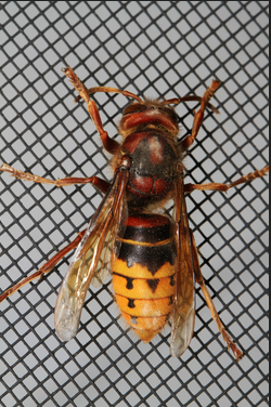
Just saw one of these gals doing helicopter recon outside my living room window..
-
I've been chirping about the operational GFS ... seeming to back off the amount of rhea whirl impact for a couple of days - been a persistent trend to do so. Now, the actual telecon layout has essentially halved the magnitude of the previous cold hemispheric signal they were carrying on with over the last two night's worth of computations. The AO's mean looks to only kiss neutral SD, where as prior all members were down to -2 SD ... and this same sort of correction has taken place in the NAO handling, too. Not sure what that will mean for us over the eastern Lakes/SE Canada and NE... upper M/A regions per se, but at least the operational GFS is getting - perhaps - some modest support from the polar index cluster. PNA is still correcting from -2 or -3 to neutral toward week two, which could mean anything really ... In January, that's enough correction in that index to send something across N/A ... not sure about April. All the while, the flow appeals to me to be relaxing - almost like the seasonal flash over the hemisphere that does seem to happen at some critical time in the models every spring. We seem to lose 2 or 3 ... maybe 4 isohypses in the full hemispheric integration from subtropics to 70 N ... by D10. It's like Roulettes ... where ever we are when the gradient music stops, we're stuck with it at the blazing speed of residual decay rates - hopefully, we're not taking three weeks to spin down some west Atlantic piece of shit
-
Meh Weeklies schmeeklies... I wouldn't trust them, or the GEFs based teleconnectors for that matter. Best April approach is to take everything with increased incredulity and skepticism, period, for anything out in time. The teleconnectors tend to be more stable over the long haul, in terms of signals and so forth and relative reliance - more so than the operational trends, simply by weight of all those members in the consensus. The higher resolution souped-up operational versions tend to be more accurate as island solutions in a sea of plausibility - it's just the the ensemble mean ( telecon number), tends to hide the correct island from time to time. Kind of the way to look at it.. But that seems to break-down in the cruelest month. One needs to remember... circa March 20th to May 2nd's ... we pass through the time of year where Satan sits at the quantum uncertainty control panel for the weather vagaries. The UN-physical seems to happen in lieu of metaphysical events that only look reasonable, ... he, or most probably a "she" uses rational saneness to conceal their presence while come hell or high water, succeeding in their ultimate goal of soring up your butt. That's why I was attempting to assess the spring all along more so by utilizing the La Nina under-pinning ENSO ( ...which is/has proven so far irrelevant so not sure why I employed this idea...), combined with the HC. Here's the rub on the HC expansion hypothesis stuff. Albeit caused ultimately by a warming world, ironically it may be causing these mid to late spring blocking deals we've been enduring in recent years. They seemed to happen in both warm(cool) ENSO...so there's something else is doing this. I think that tendency to do that has always been the case, when winters determinant patterns terminate toward more seasonal entropy of ensuing summers ... The April stalled west Atlantic REX couplet vortex climate, under modestly identifiable positive anomalies up there... all that, is not an atypical spring dilemma. I remember some doozy miserable Aprils in the 1980s... We'd get these stalled vortexes S of NS that wobbled west and then went out to sea, then wobbled right back in 3 days later.. bringing grapple squalls that mangled aggregates before ending as light rain, and shallow CB-walled horizons. Heh...it's actually rather nostalgic putting it that way. We haven't seen 'that' flavor lately... May 2005 was similar ... Anyway, the speeding westerlies wind winters, associated with the expanded HC induced gradient increase, is making that slosh-back block response more noticeable ( perhaps...) I have a feeling ... if we were to take this into the lab, and recreate the atmosphere ( simplified) around a like -thermally driven wave guided fluid system, subject it to gradient induced velocities, then... suddenly suspend the velocities, the blocking nodes would temporarily blossom there too - as a non-linear wave result. See, one cannot look at a geopotential height anomaly products, ... happen to NOT see yellow orange and red, and think that means the HC expansion stuff is not reflecting in the system. The "warmth" has already been converted to kinetic motion - that is the velocity that we've been observing as increased(ing) over the last 20 years. The "machinery" of the atmosphere, .. on whole, in the winter, turns thermal gradient potential energy into mechanical energy of wave translations, scaffold' along by the balanced base-line raging wind speed. The anomalies of the geoptential medium won't show this if at point X it is only 3 dm taller than normal - insidiously subtle - while the wind passing through that location is ludicrous speed. Anyway, the La Nina spring has a longer termed correlation ( that probably is obliterated by the HC .. seems so - ) for warmer than normal springs. But it seems this terminating block blossoming, ephemeral as it may be, is winning... Hopefully we can "get lucky" and end up in a COL between pinned vortexes and bootleg nape and warmth that way. I just hate cold after March 20... it challenges my patients...
-
I was thinking about the DP/wv physicality anyway ...as in regardless of the marine shits or Chicago shats - That's been a very noted and tightly observable bias across the whole globe ... as in, the planetary systemic atmosphere everywhere ... that elevated anomalies are more ballast in the lows at night staying high. That is a CC consequence... up goes the thermal storage capacity of the atmosphere, that increases water vapor content through blah blah --> inexorably ..that keeps night time drop off values elevated.. I don't know or see how or why that stops, just so that a product like that can look like 3 PM warm balm ( necessarily ...) ... folks need to remember when looking at charts like that: the above aspect is in play, perpetually ... everywhere, at all times, so keep that in mind. That 'inferno' could just as well be tepid warm anomalies by day, and soothing +12 at night where it's 28 F for normal anyway, making the "inferno" a caressing 38
-
You realize that just because you said this… the national guard’s gonna have to be called in for melting streets and bowing railroad tracks ... nice goin’
-
Actually ... I had yesterday's 12z run up ... I guess that's D3 --> 4 .. different then. That may actually perform on whole though the usual suspects of over zealous snow total print outs apply
-
I expect it to "tick" east and get lighter ...both. It's passing from it's weird correction - which causes over amped results over eastern N/A in general... - time, into it's better performance ( < D5 ) over the next couple .. few cycles. And in tandem with that ... the models et al have routinely shallowed troughs and made them more progressive - we all know that at this point. But, if that all ended up 1/3 or 1/2 those quantitative results, and also smeared E to be almost more of an up-slope event, I personally would not be shocked - in which case, a summit or two over performs ( probably. )
-
Ya know what tho ? ...it's a relative win if that's the case. I have seen whole summers succumb to bad rhea patterns ... WHOLE summers. 2000 anyone? That is bar none, the worst summer I can ever recall. I mean it was like 64 and drizzling every day in July or something... I think the warmest it was that year was five days of bush burning weather in October.. made 78 to 82 for a week of tinder leaf smell - finally... Anyway, I guess a -NAO pushed out 13 days has that much more higher sun angle to help offset - barring a 2000 moving in next door.
-
No off like a light switch here .. but alleviating significantly. Only counted one deeper howl and flailing tree canopy gust last hour and there are moments now when it's just a light breeze - this should be done by sun down -
-
It seems to me whenever the runs relax the flow... they flop big blocks up N...but then as the period nears, they speed back up in small amounts and it topples them... Now the GFS waits to relax the flow and has blocking out in the gaga range... It's probable that we will have to go through 'some' sort of -NAO absolute terminus to the season ...
-
12z operational GFS actually blasts the whole rhea away and out ... Sets us in to continental flow at all levels D7-9..10... Oh, I'm sure the Euro blue cakes us -
-
c'mon ... we can't trust those CNBCs and CNNs. All due respect ..the woman was completely emotional and did not offer much purer analytics to that. Just the kind of aspect those news orgs feast about because they didn't have to spin or invent to doom - it was done for them! Look - not preaching to you just sayn' ... - it behooves those c*sucker informatica orgs to doom-scroll because when people are locked down and/or fearing ...what do they do? They thumb-swipe phones and mouse click PC interfaces ...glued. The day and era that telecom figured out how to turn a thumb swipe or a mouse clicks into money...even if pennies per action, .. we were doomed alright! Doomed to ever get an honest or optimistic spin on anything they are supposed to be "informing" - they manipulate masses just as Machiavellian and immorally as the recent incendiary rhetorical, demagogue wannabe they relentlessly attached, ever did - believe me, I am not a supporter of said asshole. Not even remotely ...but I saw the hypocrisy plainly. And they know full-well the average J.Q. Jane or Jerry is just not really objectively equipped enough to adjudicate their information in a balanced sort of way that protects them from being manipulated. CNN is particularly toe-nail curling... I catch them headline doom-bombing all the time- just get the clicker or thumb swiper into the page That = cha ching cha ching in a system of economics that's got no compunctions about using fear to fetch dollars.
-
Yeah that's fascinating actually - this is mentioned out of the side of the previous CDC directors mouth in the interview with that Sonjay Gupta ( CNN medical correspondent ) ... Former directors personal opinion is that this thing originated in a Wuhan laboratory - that was one of the aspects he danced around, that it's biological presentation in the population is perhaps "too novel" 1 ... it was not doing what new viruses typically do; they have to go through thousands of generational failed iterations before they figure out the right combination to unlock targets and proliferate in a new species. This one? boom - no iterations required... Whole world gets sacked within 3 months of 'newness' 2 ... just because that was so, it probably was an accident - we do this all the time in our laboratories across research ambits all the time, where we alter infectious agents to make them more virulent, so that we can study the infection process more efficiently ... they may have/probably were doing the same thing, and then someone got on their sleeve and the 4 months later no one's getting laid again - apparently .. f! 3 ... I heard that - my own opinion - and I thought it immediately offered some explanation as to why there is no clear pattern of who gets it and doesn't. "Intuitively" that seems to make sense - which is a euphemism for not being a genetic engineer so wtf do I know. But ... if they were tailoring a virus for some particular acute attack sequencing for experimental research, and hit some recessive trait ... you got that trait, your the 40 year old marathoner with a big dong vitals close to intubation while someone else's sister gets a head-cold.
-
We got forsythia bud swelling ... as much as can be discerned. They are small anyway.. But the lilac buds opening. There are some other random undergrowth shrubbery that appear triggered, and fields around town are green tinting. Major over hang tree/canopy types are still asleep. Although there some Dutch elm that look like they may be flowering, but those are mid growth ones in my town - they don't make it to old age before they succumb to the disease native to that species.


