

Typhoon Tip
-
Posts
44,477 -
Joined
-
Last visited
Content Type
Profiles
Blogs
Forums
American Weather
Media Demo
Store
Gallery
Everything posted by Typhoon Tip
-
I'm not insensitive to your particular interest area in following this/engagement ...etc, so this is just fwiw ... But, I would be careful using any GFS solution as a standard practice, for any range beyond ~ D4. Particularly in spring...when the flow is concomitantly attempting to relax and elevate heights ...the GFS is unique UNqualified to get that memo... heh The model maintains a pretty coherent N/stream bias - speed and dominance therein, ablates ridge signals too liberally ... as well, stretches trough into the x-coordinate ( w-e); and it is an error that I have noticed only gets worse the further out in time. It seems to have an issue with lowering heights too far N of the westerlies ...and then that means the gradient is overdone ... and the balanced wind ( we call those geostrophic wind fyi ) speed up accordingly. That creates a base-line biased feed-back on its self, such that it worsens farther out in the extended ranges. That said, I have personally been entertaining the notion of a cut-off/West Atlantic ..marginal type deeper solution potential around the 1st of April, anyway. I also wonder if April is destined to be way above normal after that. And if it doesn't happen...we may really have seen the last snow chance - ...I do this every year on a personal note, and fail ...I try to say when, "That! that was the last snow I'll see ..." and I always have to have it dawn on me later on. I didn't know that time to even ask if those squalls would be it last week - We'll see
-
19 to 55 so far ... Impressive 36 change/rise from 6:35 am bottom -out
-
Nice! ... I admit to this being one of my personal weird little fetishes, how far we can get the temp to rise from daily nadir to apex. The most I have ever seen in my life was not even attributed to a radiational cooling to open sky insolation - like tomorrow's forcing will come from. It was in January 1994, when it was 9 F at dawn with pixie flakes and tiny aggies flitting down... By 7:45 that evening it was 63 with S winds gusting to storm force with kelvin-hemholtz waves of cold steam rollin' off snow banks.... Granted, that's UML/ Merrimack Valley in NE Mass/Lowell ... Maine has their own climate and I am not frankly sure what kind of diurnals are standard deviation extremes ... At either region, this is the time of the year to put up some big radiation - insolation relay variances though. When you get kinetically primed air masses with low DP ( rotted polar basically...), then equi-sol... But 42 ... man, that's impressive.
-
Kind of a geek alert but the overnight, tonight to about 21Z tomorrow could rival any of the larger diurnal changes we've seeing across the last year. I think I recall a couple in Feb that were 32-ish... but tonight? First of all, that's going to suuuuuuuuuuuuck major lemon balls - who in the world would want 15 F decoupled cold on the Equinox when there is no snow to protect, and pretty much nothing on the determinant horizon that resembles a chance for a nary flake? Even winter enthusiasts probably would say, 'I'm crazy - not stupid' to that f loo-loo look tonight. My god what a dick punch. I mean I'm looking around ...DPs like 5 for f sake. You gotta be kiddin' me... But tomorrow's parameters send the temp to 60 and bust MOS I'm think... or so - I mean above MOS in general. If we can get into the upper teens tonight, that's a interesting diurnal spread. In fact, all these days look that way coming up - although none will be as cold as tonight
-
Amazing how there's no statistical outliers on that list -
-
With a last gasp effort, winter 20-21 refuses to give up the ghost
Typhoon Tip replied to moneypitmike's topic in New England
Subtracting the Euro's coherent amplitude bath its suddenly applying to trough out of no where D7 into 8 ... the entire run otherwise really looks very spring-like here. -
Zippo trace of spring in flora above or ground level out here along Rt 2 in N-central/NE Mass... Usually be early March, forsythia shrubbery's been fooled into at least bud swelling but we got nadda. Suspect that changes by mid week. The difference between today and tomorrow will be very noticeable. 42 struggle, tomorrow should bust NWS MOS 55-58 coverage to 60 - although I'm seeing less of that on these sort of synoptic days. I wonder if the 'brain'/database is catching up finally.. unknown. Anyway, looks like 58 to 68 until at least Tuesday ...then we'll see if that lingering thing off the SE coast drills a Labrador vomit hose inland mid week... I think overall..this may be the last of 'this' kind of cold, though. The atmospheric agency has sent the memo to the other butt-bone office to tell them they can take over how/when/why we get porked going forward. Lol..
-
Doesn't seem so on the surface, no. But, I'd caution for the general reader: -- the HC expansion does not = warm winters and no snow. What it does equally is screwing with patterns and teleconnection correlators, and f'ing everything with too much velocity toward unexpected results... Meanwhile, the AO was dominate this year. Considering the La Nina/EL Nino/general ENS and the AO have a longer term, noisy correlation that if anything is vaguely negative, that more so suggests that either can be dominate without necessarily controlling the other. Cold Jan/ Feb may have been provided through the polar circuitry and the flow still was fast overall - so that's more of a smoking gun for gradient up underneath, persisting. I guess eventually if that expansion continues... sure... we may start seeing - perhaps - these climate bands moving N up the eastern seaboard. That's predicated by climate modeling by the end of X - years. As a separate note, there are a lot of empirical measured aspects that are exceeding the CC models ( timing -wise), too... just sayn'... Plus, thresholds? I mean, folks say things "we'll be DC winters here in 20 years" ...and then someone heavy-handedly corrects them that it will be safely 100 years from now and outside their lives, and the usual mantras of evasive tactical shit to me... when the fact of the matter is, that person doesn't know! We could cross the threshold that no one saw coming and boom, we be f*ed. Anyway, this is an evolving aspect of climate change. It's effects/ observability in the environment of course will vary ... year to year, based upon other aspect globally going on.
-
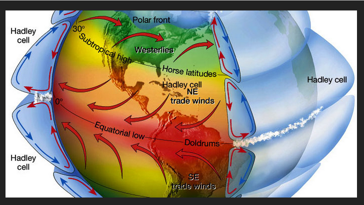
My hypothesis, it's actually the HC expansion curse that strikes ... 'what the f does that mean?' Firstly, this may be long for some - but there isn't really a way to present this material 'quickly' as it is multifaceted and complex. So, if reading and engaging is not your interest, you've been advised. Hadley Cell is the amorphously boundaried circulation associated with rising deep tropical air that in turn moves polarward at very high altitudes, where it then begins to move downward. The physical volume of the HC region you see in the anime above has been measurably expanding in recent decades... owing - it is believed - to climate change and warming total ambient atmosphere: https://science2017.globalchange.gov/chapter/5/ This has all kinds of ramifications and forcing at mid latitudes, but for brevity ...expanding into the subtropical latitudes by insidiously small amount, actually "compresses" the gradient every N of there, because the boundary of the HC is not a "curb" in free air/space. The integrate slope between 30 N and 70 N is steeper than 50 years ago. As an aside ...this is why commercial airline traffic have seen a marked increase in air/land speeds ...even setting records, on flights traversing over oceanic basins over the last 20 years with increased frequency. When traveling W to E in a fast maelstrom, the jet moves faster than the streamline velocity to maintain lift - but if the streamline is moving at 200 kts already, the airline ends up moving in relation to the stationary land at 200+ 400 = almost sonic speeds. I think I read once of a flight between LGA and Heathrow up in London 3:45:00! SO ...this is the real October curse - how? It is because as the summers are relaying the torch into autumns, the flow is speeding up ahead of the previous climate model that was in place prior to the last 20 years of "hockey stick" climate. In that prior time, we had more nebular flows in autumns. These transported comparatively shorter lived "cool" snaps as opposed to full-on snow supporting synoptic outbreaks Those then backsided these 'Indian Summer' etc - just a matter of time before the cancel culture hits that naming convention ... Then, the colder heights of winter gathering mass would service mid latitudes later on. That was the 'basic' sort of seasonal expectation. But, with the speeding up flow..this is establishing earlier season pattern tendencies that are non-nebular. And, because by virtue of just coming off the N.H. warm season, there is a natural tendency to build heights over western N. America as the Pacific flow impinges against the super-synoptic/geographical circumstance of the continental forcing ... Perennial North American Pattern ( which is not the same as the Pacific North American - ), gets a boost ...which then leads to the PNA getting early season exaggerated. Cold loading become proficient earlier mainly Canada; but, given our particular geographical constraints that favors our tapping those air mass in events... See where all that's going..? Next thing we know...we have cold transports at usually early dates setting up actual snow shots across the bow, as opposed to mere cool snaps, as the harbingers of winter... A similar seasonal lag effect is happening at the other end, too... where the flow is lingering fast into spring, and as March sun sweeps back N and starts cooking the hemisphere..something similar takes place ... we get late pattern augmentations supporting cool transports in April and May - but it's not as abrupt as the October/Novemeber autumn version...etc. These are not every year occurrences in transition seasons. They are increasing frequency -related matters. But, this does not parlay to winter - either direction. What is happening is, the hemisphere then finds it's winter gradient/ R-wave tendency, and that then effectively wipes out that transient seasonal lag effect... and that pattern in the ensuing winter may or may not support snow for entirely different pattern related reasons. You have to consider October and the winter as mutually exclusive in that sense. But we are human... and humans tend to seek and find patterns in nature, ...so much so, that if there isn't really one, they will latch onto plausibility to make sense of it all... So, it snowed in October, ..the winter was bad, two points make a pattern. But there not really related really in this hypothesis of transition seasonality.
-
With a last gasp effort, winter 20-21 refuses to give up the ghost
Typhoon Tip replied to moneypitmike's topic in New England
The convective sequencing idea has merit as phenomenon in itself. I'm not entirely sold it is primary in why this event did not snow more above NYC, along ALB to BOS. That region averaged .6 to .9" of rainfall... which is still 70 some-odd percentile of the QPF - however, I would point out that that could be explained without 'convection robbing' For one thing ... convection explosions seed latent heat exhaust downstream. That tends to fix/correct heights higher immediately astride along the right side of the storm tracks. This can cause cyclones to track NW of guidance ... albeit more or less demonstratively so. I mean it can be subtle. But here's the thing ... this was losing cyclogenic kinematics as it was moving E on whole ... devolving into an open baroclinic field. There really was "less or even no cyclone to correct" So perhaps ... if there was no convection at all.. the ANA aspect would have lingered longer ? yeah maybe... But that may be too difficult to parse out anyway. I would also point out that models typically over dose ANA QPF to the surface, too long and much - I wonder ... if there is a standard error ANA, and if this events 'missing' QPF ...I bet it closer to the model bias. -
With a last gasp effort, winter 20-21 refuses to give up the ghost
Typhoon Tip replied to moneypitmike's topic in New England
Giving or taking - -
It actually looks like a locked pattern with multiples going that way. It may not be people’s interest area around here but I’m wondering what that might mean for our convection season as we get closer to May. I think the south east ridge is going to make a presence more often than not this spring is where I’m going with that - I’m inclined to watch around April 1 for a cut off, too. Bowler
-
With a last gasp effort, winter 20-21 refuses to give up the ghost
Typhoon Tip replied to moneypitmike's topic in New England
Okay. You win. I’m all that. -
With a last gasp effort, winter 20-21 refuses to give up the ghost
Typhoon Tip replied to moneypitmike's topic in New England
I did ? ... one has vastly more profound aspirations than seeking credit in that sense, in here. I said "WE" as in the collection of all, specifically to avoid that context interpretation - so.. you clearly have an agenda to read in ( the wrong way..) to get that conclusion. Look, folks should not have gotten their hopes up for this storm - ... your bringing that up sounded a bit like a redirect of your own anguish by finger wagging everyone else, as though we were not listening to that sort of advice. But we did already ... get it? maybe that interpretation was wrong? fine - but that's a typical antic in here, and THAT is vastly more annoying than someone who bothers to write paragraphs. -
I think if it works, ... don't f with it, then... right? I mean, so people are getting in ahead - who cares. If it ain't harming anything, we're closer to herd immunity .. or whatever it is called when it's a combination of self-resolved and vac populous - actually... come to think about it.. .what's the difference ... Anyway, a year ago roughly two weeks before thanks giving I was stricken for a week... 4 to 5 days of which put me through a sequence of symptom progressing that pretty much was identical to the COVID-19 package. But, ...no, it wasn't recognized on the global stage until a month later, mid Dec of 2019 - I can't believe we've really just passed through a whole year of this shit.. Might be the fastest perceived year of my life - weirdest too for other personal reasons. Now, China leakage ... I read somewhere that China is admitting this thing or it's ancestral root was in circulation in the general public much earlier in 2019. Rumor has it ( so it is likely untrue...) that up in Ireland/Isles they are exhuming bodies and finding that C-19 was present in corpse that also succumb to "strange illness" earlier that year. ... As usual ... I'm digressing. My point was going to be, I wonder if some of us had this? I'm < 55 and by western civility standards in ridiculously good shape...so, I'm a likely candidate to self-resolve. I had fever, dry cough, and fatigue and headache... lost of appetite... and my gourmet coffee tasted bland. Other than that ... I actually didn't eat much other than three donuts over the course that week. But it was bad. I was in pools of sweat at night.. wobbling down the stairs in the morning. Couldn't regulate body temp.. Then on D3 the cough got a little wet and lung gurgling kicked in... but it only last 1 day, and both it and the dry cough rather abruptly disappeared by day 5 and by D6 I was out.
-
...A time like this in this particular social-media mise-en-science ... is like attempting to moderated a cat fight dressed in dog costume. Particularly in a sensy motif brought about by a last season mercy snow event that busted - it was like not an exit hurrah at all. It was like the scene in "Airplane," ...where Leslie Neilson's character was trying to cinema-trope slap the hysterical female passenger into calming down, and when asked to step away ... he hesitates, and steps back in to get that one extra slap in - Love that ... hi - larious ... continuing the metaphor, as Leslie fades out the camera then pans down a line of people waiting to take turns on her, boxing gloves, ... baseball bat, even a crescent wrench, samurai sword and guns - that's summer for many. But, this winter is Leslie Neilson, and the hysterics of winter ending with this way is the extra slap being received. LOL
-
With a last gasp effort, winter 20-21 refuses to give up the ghost
Typhoon Tip replied to moneypitmike's topic in New England
I seldom want to get into the grading wrangle but what time I've given to it - I think this year fairly falls below average in grade... less than a C ? My philosophy is more adhering to climate. IF we get at or around average ... that's a C... If we go above average ... etc etc... but, in pure numerology - landing on climate should really be a 100 ...I give in want as a failing...I know - It's a subjective scale of course... people in the public ambit need to have their agenda fullfilled and that's fine. But, if someone needs to get 65" to get a C ...and still reserves the right to grouse and call it grudging... all I can say is, man - glad I never took Calc II under the yolk of that teacher's grading policy. Anyway, I set at 53.5" for the year I believe .. .I think that's 5 less than average if it ends like this - I mean ... I would never on March 18 think it does out of hand in this butt-boned capital of the world. But ...I don't care for snow much going forward, full disclosure so... D+ is what it is if so. Fine - -
With a last gasp effort, winter 20-21 refuses to give up the ghost
Typhoon Tip replied to moneypitmike's topic in New England
Don't read them, then - don't want to cause you any anxiety or undue stress in the matter - lol. jesus - no...your being douchy this Why, was someone abasing/impuging Bouchard ? .. -
Funny... the Euro stalls the 2-m temp 55-59 across the area on Sunday and ... that just does not fit a-priori or existential awareness of what that does at this time of year. It should be mid 60s minimum - and 70 would be nicked over back patios and driveways. I'm willing to nod to lack of mixing being close to the centroid region of the high pressure bubble... and that might not realize the BL being that tall, but even the 925 mb adiabat is 64.. 65 at HFD that afternoon. I think it stops adiabat at 900 mb or something and doesn't render it to the 'real' surface? but then why would that call that the '2-m' ? I dunno -
-
More than less, yup - but, I also add that the increasing, ...at the other end, dimming, that begins to accelerate in either direction on Feb 8 then Aug 8... - adds to it for coinciding an actual empirical physical metric like the actual sun power. On May 8 that acceleration begins to actually slow through June 21 and tho we lose through Aug 8, ...it speeds up markedly then.
-
It always occurs to me ... Dec 21st ithe shortest day of the year.. that's all that is. It happens to be the solstice. Maybe the meaning of winter is misnomer'ed over the course of history. But as a climate distinction, it lapses that date enough in either direction depending on the given year's vagaries of the patterns ... There's nothing really magical other than to say, 'shortest day of the year' - doesn't mean much else. Calendars? Human invention.
-
I've been told by several who've been vaccinated that they were lax at best re any sort of background screening and mostly - they don't really check - It's not like you're being glowered at, "where's you papers..." outside of Stalingrad circa 1939 ... They ambled in and claimed they have a-b c job or x-y or z co morb and it was sit here and get poked - I mean, there's lists sure... criteria for who gets what based upon whatever - but you know, it's a logistical infeasibility to expect every tom dick and suzie marry to provide some kind of proof of ailment passport
-
Jeez ..lol, I mean that's only one legit paragraph otherwise .. a sprinkling of 5 or so sentences - Yeah I know... hey, that took me 5 minutes to type - and no ..in case anyone is wondering, I am not on my phone at a food pavilion in a Mall or waiting on someone curbside for a ride. I work from home and sometimes days are slow - like today... I thought that was funny - ... 'pissed off hornet looking to sting anything in blurry sights' ... made me laugh typing that -
-
With a last gasp effort, winter 20-21 refuses to give up the ghost
Typhoon Tip replied to moneypitmike's topic in New England
We've been talking about too, for several days... Just sayn' -
... seasons change when they do... Kind of an oxymoron to say "..We done" and then suggest a couple more days - which is it ? lol ... I know what you meant though. For me, spring begins on February 8th every year. Winter begins on November 8th ... Why, because I derive pleasure from annoying people... but also, Nov 8 thru Feb 8 is the solar mimimum of the year. That's when the solar insolation power of the sun dish-pans ...even on sunny days ( for example ...) snow packs are resistance at 40 N latitude... Minimum's duration of course is shorter south, and longer N of our latitude and so on and so on.. The max around here is May 8th through August 8th...and that is summer in my crazy world. Everything in between those is spring/autumn, respectively... That's if going by like Math and actual celestial mechanics of astro physics - ... But, we here on Earth as mere mortals have this pesky bias of being drilled into what effects/affects at a sensible level - ...to our senses, climate lag dictates the seasonal changes ...as ultimately directed by what can be felt and is observable, therein. Warm weather returns ... buds swell...confused hornets come out of winter slumber addled and pissed off because they haven't had their morning coffee and set to 'dry stinging' anything in their blurry sights - hate that. But all that usually doesn't really get going until that first April true 4 days of 70 with nighttimes staying well above freezing.. (Usually just before the orchard killer blue urinal cake snow event .... but that's another annoyance altogether )


