

Typhoon Tip
-
Posts
44,264 -
Joined
-
Last visited
Content Type
Profiles
Blogs
Forums
American Weather
Media Demo
Store
Gallery
Everything posted by Typhoon Tip
-
I had a buddy that toured the station back in '95 I think it was, and he told me that when he walked into the studio and Mark wheeled around in his chair, he had that look, but was wearing Hawaiian patterned shorts, and the 'cast was waste up - and while they were there...he did the report like that. And his demeanor was otherwise like a burn-out ... 'Yo dudes, wuz up' lol I could see that with that mullet look. Thing I remember about that storm ...among many aspect, is that while it was happening ...knowing that Wed had that temp recovery look to it. That was up in my UML weather lab days... I think it nudged 60 the end of the week. It was like a cocoon storm - hiding from the inevitability of spring inside a transient winter fantasy... I mean by then my gears are switched normally? And I prefer not - but I will play the hypocrisy card if the situation warrants and that one more than did, and so once inside the bubble ... knowing how short lived that would be kind of tainted that. But, like we've said...those diabatically assisted spring deals... I don't think you can get that in DJF? Just like we've often mused 'what might have been,' of that 1992 December legend ... I don't think Brockton Mass can get 5.5" of rain and then a foot of snow and have that been ALL snow - I dunno... If it did, that would have been 50" to 60" at/of 10::1 ... I wonder if they'd still be without power. No sea level storm has ever done that and I wonder if colder profiles - it makes some physical sense to think that cold holds less water so ... you may not geophysically be able to do it.
-
Lol... yeah, just title the thread, ...while we're at it
-
I really don't wish to be all that engaged in any drought discussion ... However, just as an observation and experience: I feel the next 3 ...maybe 4 weeks will be key in setting us up the rest of the way this summer - unless we do like a June 1998 thing.. The total soil moisture and longer term moisture deficits states are crucial to seasonal resilience. When there is an abundance of arlier/warmer spring conditions , sans "April showers" normal, that climate leads to top layer issues accelerating ... pretty fast as early as late May per my own experience. April rain is more than an affectation... Sometimes this happens with earlier warmth prior to continental green up - green up adds atmospheric moisture, clouds and thunder follow were moisture is present. Pretty easy arithmetic there... But when desiccation abounds prior to green up, this has a nasty negative feed-back on soil moisture ...setting the gears toward a beige lawn by the 4th of the July, as well as crop/gardening problems.. But this is no reasons to play volleyball with U.S. DS charts all summer long either.. Obviously, 70/ 25 dp ...sucks water out of anything - including the earth... This can happen prior to reservoir depletion, which res level reduction doesn't kick in - in my own experience - until August, provided the previous year was sufficiently wet to get them at capacity prior to the onset of the warm spring in question. Basically ...there is a lot of lag facets to this hydro shit. We don't have a warm spring .... yet. What we have is the expectation of one, with perhaps 2 days and counting - if we negate the lows last night and priors... These diurnal averaging policies do a warm pattern a disservice at this time of year. But, it can be warm, we just need the anti-stein events to punctuate over the course of these 3 or 4 weeks
-
This could be truly hot summer ... wow - the lower RH free rise variety -
-
I remember clearly last week when we were scoping out this nape pattern ...the Euro's 2-meter temps were consummately in the 50s ... We've been 62 to 67 over patios, driveways and downtown thoroughfares this whole go and will remain so.. Anyway, given the synoptic set up of parameters and evolution by the Euro, it's 72 2-meter could also error that much Thurs -
-
It does, Kev - yup.. That 00z Euro run has over-performing 2-m written all over it. It's got that surged warm-sector look, where the 10C 850 isotherm gets kissed on the coarser charts ( PSU ) by the +12C running up parallel and very close to the 10 C isotherm, packed in ... With multiple pressure lines situated not hugely close but close enough, it's like the perfect SW flow flag wobbling to mix the atmosphere too. 850 mb may actually be the boundary layer depth. That's code for maximizing the +12C down to the surface, then including the 2-m slope part of the sounding? Mm yeah probably puts up an 82 F at BDL if that model and that look for Thursday ~ 21Z is precisely correct, which ...there are other models. But the Euro being inside of 4 days on that? heh... good luck. .. Either way, I'd hit that mid 70s that day for a good chunk of everywhere S of Albany to Brian.
-
What an amazing correction for PF to Phinney land on this GFS run.. . Puts a band of heavy snow QPF for 9 hours through that corridor as near as 108 hours...after days of runs that trended into southern Canada too - haha...
-
In a sense if it : ...it's trying to offer a spring like blue-bomb potential, but it is doing it along a CC climate adjusted N latitude. ...Miller B's from Upstate NY to Gray Maine/GOM is fun for Montreal I guess... That's what the GFS appears to be after - but Climate Change thing is half-hearted snark too. But forgetting that humar, the V16 and the operational runs have been displacing a spring event N of typology for whatever reason. The problem I have with both are still what I pointed out yesterday - seeing as people give a shit what I think...haha. Whatever, read this don't read this: The Euro over amps, as a flash correction it applies going from mid to extended range. This feature looks suspiciously like it is doing that ... It takes what looks more like a negative node between the ridge signatures ( day 5) ...and converts it into hemispheric torsional presence .. 'why'? It really gives it a structural sort of curvature boost by the D6 to 7 relay going from the upper MW to the OV/90W region. Where then of course it has all that structure going into D8 ..boom! But it may all be fabrication over the previous 40 hours ...setting that into motion and as an aside, I think that is EURO product problem that may be more endemic to just eastern N/A due to our continental/PNAP feed-back... It positively interferes with their famed systemic 4-D variable ..extra double top secret correction scheme. That's why those of us over here in the U.S. know to be incredulous about the "dreaded D8 Euro" bombs. ( the same group that seems to always forget that when the chart comes out of course haha) The GFS has a problem on balance of being too cold on the polar side of the westerly(s) jets ... It's probably got ongoing dynamics problems because all graduates since 2000 achievement factulties are scaffolded by a combination of iPhone look ups and cheating on exams... So, whatever their charge, their razor sharp geophysical understanding causes too much height falls in the vicinity jet maxes .. Whereby it then it too ends up with a self-manufactured surplus of cold heights... --> too much gradient --> speeds up the flow --> progressive bias results. Seriously... because of its bias, at this time of year that particular model will be badder - heh... I mean spring's modulate baroclinic gradient... filing cold ..etc... It fighting that, nutating away from seasonal progression in lieu of its ongoing biased gradient offset. But here's the insidious thing - the HC shit appears to imposing more gradient in the seasonal means, anyway... So, this bias of the GFS cluster is operating in an enabling sort of system... In other words, the flow is fast anyway and has verified that way... dedacal at lengths at this point, too. ENSO warm...cool... nada ...didn't matter. The telecon layout from the GEFs actually signals a cut-off 'bowling ball' or 1997 look though. So, ...these cons above are not targeted at whether a system will be there to monitor - I think the signal stands for its self in that regard. But how/what to suspect of those models in that time range.
-
Two aspects stuck out to me on that 25 mile ride yesterday ... The still waters of the regional ponds and lakes were like mirrors. That's unusual in our climate moving through mid to late afternoon. The diurnal solar hammer usually sends enough BL cycling vibrations to stir up at least ripplet shimmering but they were totally smooth reflectors. The other aspect is that despite taking out the Rockhopper ... you could hear their horny song penetrte the knob whir of that bike's tire type. I remember thinking about momentarily weird ironies, of riding a Rockhopper, with that happening... which compares an effect of the Rockhopper against an organism that prefers to hop along on rocks. lol
-
It's actually a monthly late, while also being extreme - both distinctions.. interesting. Typical - have fam members that are heavily into the maple - this kicks in around Feb 20 each year up along and N of Rt 2's inland climate zone, where it's 49/24 type stuff. This year we those cold snaps that seem to belay matters ... But here's the thing that makes this interesting is that pure statistics were not unusually cold for Feb at most major climate sites. HFD was -1, but ORH/Logan were both modestly positive by decimals... So it's like paradoxical in that sense - somehow achieving normal February and the foliage believing it was too soon to be normal. Looking at the dailies, it appears the numbers are classically lying about what took place, ...lost in averaging the low temperature may be pulling much of the weight there. Anyway, they don't typically have to wait until the end of March and/or diurnal spread as large as 65/24 to get the sap spigots running.
-
This is true ( bold ..) I've been largely staying out of it - frankly, because I'm being douchy and don't want it. LOL But here's the thing - objectively: - All the deterministic models, regardless of which have been routinely over-amplifying everything their physics see at those longer leads.. They may be all doing so for their own reasons. It seems the Euro takes whatever it's handling at D4 and adds a third more amplitude to it on D7 ... Then, spends the next 3 cycles eroding it back. The GFS on the other hand as an N/stream hemispheric monster intent ..services troughs with too much feed-back, and that perhaps is two different reasons those models end up with too much D8 amplitudes... Not sure. - Seasonality is a factor. If correcting for Euro flash correction scheme adding too much, and assume the GFS is a "Good For Shit" model because they keep f'ing "upgrading" it to an ever worse propensity to 'hide global warming' ... ( kidding out of frustrating ), the sun/hemispheric changes can at time un-seat these amplitude looks for that reason alone. I have seen countless large modeled trough closures end up cirrus whirls for having the models maintain too much deep layer baroclinic parametrics ...it's like they don't integrate the solar modulation aspect properly most of the time in Springs. But, big nasty cold events do happen through April... It seems to be timing is crucial in getting the deeds down; the cold insert needs to happen sort in a critical window, or the whole structure falls victim - we're in that time of year after the Equinox... Deterministically ...these are offsets. In favor? The NAO is rising as the PNA is showing a couple of camel bumps out there. That is actually a likeable telecon layout. The flow wants to lift in latitude, but the PNA may deposit meaningful wave in there... and that may close it off. Come to think of it I actually mentioned that to PhineasC a few nights ago in passing ...so it's been sort of out there -
-
- that's funny ...I forgot about that old index finger rule. right - Mt Washington We used to employ that down here actually, for whether 101 has a shot at Logan - I mean ... barring other bs like cloud timing and wind direction, MWN needs to be about 72 F at dawn MWN - I 'think' it was something like this. There's others... Like, you look for 22 kts 850 mb from S as to whether the 32 F penetrates the interior down here in SNE in SWFE' or icing scenarios.... That's from the old days of Taunton NWS back in Walter's late 1980s ... But it works in general whenever there's denser air mass lodged E of the Berks and Whites ..- there's probably exceptions but just as a general rule. S at 25 kts at 850 mb and no matter what, icing ends... 21 kts, they're extending advisories because it lingering longer... Or, BD air masses gobble up the extra day and tediously aggravate because people were told the warm front would blast back through.. lol
-
I'm not insensitive to your particular interest area in following this/engagement ...etc, so this is just fwiw ... But, I would be careful using any GFS solution as a standard practice, for any range beyond ~ D4. Particularly in spring...when the flow is concomitantly attempting to relax and elevate heights ...the GFS is unique UNqualified to get that memo... heh The model maintains a pretty coherent N/stream bias - speed and dominance therein, ablates ridge signals too liberally ... as well, stretches trough into the x-coordinate ( w-e); and it is an error that I have noticed only gets worse the further out in time. It seems to have an issue with lowering heights too far N of the westerlies ...and then that means the gradient is overdone ... and the balanced wind ( we call those geostrophic wind fyi ) speed up accordingly. That creates a base-line biased feed-back on its self, such that it worsens farther out in the extended ranges. That said, I have personally been entertaining the notion of a cut-off/West Atlantic ..marginal type deeper solution potential around the 1st of April, anyway. I also wonder if April is destined to be way above normal after that. And if it doesn't happen...we may really have seen the last snow chance - ...I do this every year on a personal note, and fail ...I try to say when, "That! that was the last snow I'll see ..." and I always have to have it dawn on me later on. I didn't know that time to even ask if those squalls would be it last week - We'll see
-
19 to 55 so far ... Impressive 36 change/rise from 6:35 am bottom -out
-
Nice! ... I admit to this being one of my personal weird little fetishes, how far we can get the temp to rise from daily nadir to apex. The most I have ever seen in my life was not even attributed to a radiational cooling to open sky insolation - like tomorrow's forcing will come from. It was in January 1994, when it was 9 F at dawn with pixie flakes and tiny aggies flitting down... By 7:45 that evening it was 63 with S winds gusting to storm force with kelvin-hemholtz waves of cold steam rollin' off snow banks.... Granted, that's UML/ Merrimack Valley in NE Mass/Lowell ... Maine has their own climate and I am not frankly sure what kind of diurnals are standard deviation extremes ... At either region, this is the time of the year to put up some big radiation - insolation relay variances though. When you get kinetically primed air masses with low DP ( rotted polar basically...), then equi-sol... But 42 ... man, that's impressive.
-
Kind of a geek alert but the overnight, tonight to about 21Z tomorrow could rival any of the larger diurnal changes we've seeing across the last year. I think I recall a couple in Feb that were 32-ish... but tonight? First of all, that's going to suuuuuuuuuuuuck major lemon balls - who in the world would want 15 F decoupled cold on the Equinox when there is no snow to protect, and pretty much nothing on the determinant horizon that resembles a chance for a nary flake? Even winter enthusiasts probably would say, 'I'm crazy - not stupid' to that f loo-loo look tonight. My god what a dick punch. I mean I'm looking around ...DPs like 5 for f sake. You gotta be kiddin' me... But tomorrow's parameters send the temp to 60 and bust MOS I'm think... or so - I mean above MOS in general. If we can get into the upper teens tonight, that's a interesting diurnal spread. In fact, all these days look that way coming up - although none will be as cold as tonight
-
Amazing how there's no statistical outliers on that list -
-
With a last gasp effort, winter 20-21 refuses to give up the ghost
Typhoon Tip replied to moneypitmike's topic in New England
Subtracting the Euro's coherent amplitude bath its suddenly applying to trough out of no where D7 into 8 ... the entire run otherwise really looks very spring-like here. -
Zippo trace of spring in flora above or ground level out here along Rt 2 in N-central/NE Mass... Usually be early March, forsythia shrubbery's been fooled into at least bud swelling but we got nadda. Suspect that changes by mid week. The difference between today and tomorrow will be very noticeable. 42 struggle, tomorrow should bust NWS MOS 55-58 coverage to 60 - although I'm seeing less of that on these sort of synoptic days. I wonder if the 'brain'/database is catching up finally.. unknown. Anyway, looks like 58 to 68 until at least Tuesday ...then we'll see if that lingering thing off the SE coast drills a Labrador vomit hose inland mid week... I think overall..this may be the last of 'this' kind of cold, though. The atmospheric agency has sent the memo to the other butt-bone office to tell them they can take over how/when/why we get porked going forward. Lol..
-
Doesn't seem so on the surface, no. But, I'd caution for the general reader: -- the HC expansion does not = warm winters and no snow. What it does equally is screwing with patterns and teleconnection correlators, and f'ing everything with too much velocity toward unexpected results... Meanwhile, the AO was dominate this year. Considering the La Nina/EL Nino/general ENS and the AO have a longer term, noisy correlation that if anything is vaguely negative, that more so suggests that either can be dominate without necessarily controlling the other. Cold Jan/ Feb may have been provided through the polar circuitry and the flow still was fast overall - so that's more of a smoking gun for gradient up underneath, persisting. I guess eventually if that expansion continues... sure... we may start seeing - perhaps - these climate bands moving N up the eastern seaboard. That's predicated by climate modeling by the end of X - years. As a separate note, there are a lot of empirical measured aspects that are exceeding the CC models ( timing -wise), too... just sayn'... Plus, thresholds? I mean, folks say things "we'll be DC winters here in 20 years" ...and then someone heavy-handedly corrects them that it will be safely 100 years from now and outside their lives, and the usual mantras of evasive tactical shit to me... when the fact of the matter is, that person doesn't know! We could cross the threshold that no one saw coming and boom, we be f*ed. Anyway, this is an evolving aspect of climate change. It's effects/ observability in the environment of course will vary ... year to year, based upon other aspect globally going on.
-
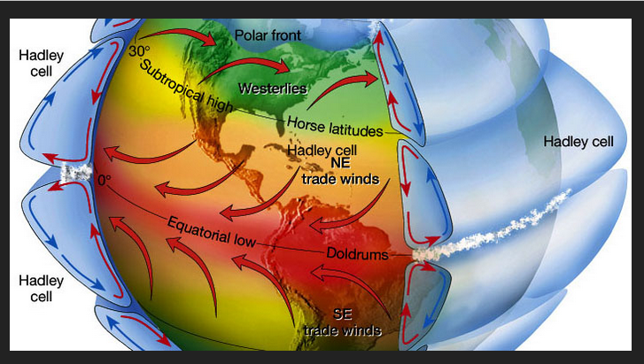
My hypothesis, it's actually the HC expansion curse that strikes ... 'what the f does that mean?' Firstly, this may be long for some - but there isn't really a way to present this material 'quickly' as it is multifaceted and complex. So, if reading and engaging is not your interest, you've been advised. Hadley Cell is the amorphously boundaried circulation associated with rising deep tropical air that in turn moves polarward at very high altitudes, where it then begins to move downward. The physical volume of the HC region you see in the anime above has been measurably expanding in recent decades... owing - it is believed - to climate change and warming total ambient atmosphere: https://science2017.globalchange.gov/chapter/5/ This has all kinds of ramifications and forcing at mid latitudes, but for brevity ...expanding into the subtropical latitudes by insidiously small amount, actually "compresses" the gradient every N of there, because the boundary of the HC is not a "curb" in free air/space. The integrate slope between 30 N and 70 N is steeper than 50 years ago. As an aside ...this is why commercial airline traffic have seen a marked increase in air/land speeds ...even setting records, on flights traversing over oceanic basins over the last 20 years with increased frequency. When traveling W to E in a fast maelstrom, the jet moves faster than the streamline velocity to maintain lift - but if the streamline is moving at 200 kts already, the airline ends up moving in relation to the stationary land at 200+ 400 = almost sonic speeds. I think I read once of a flight between LGA and Heathrow up in London 3:45:00! SO ...this is the real October curse - how? It is because as the summers are relaying the torch into autumns, the flow is speeding up ahead of the previous climate model that was in place prior to the last 20 years of "hockey stick" climate. In that prior time, we had more nebular flows in autumns. These transported comparatively shorter lived "cool" snaps as opposed to full-on snow supporting synoptic outbreaks Those then backsided these 'Indian Summer' etc - just a matter of time before the cancel culture hits that naming convention ... Then, the colder heights of winter gathering mass would service mid latitudes later on. That was the 'basic' sort of seasonal expectation. But, with the speeding up flow..this is establishing earlier season pattern tendencies that are non-nebular. And, because by virtue of just coming off the N.H. warm season, there is a natural tendency to build heights over western N. America as the Pacific flow impinges against the super-synoptic/geographical circumstance of the continental forcing ... Perennial North American Pattern ( which is not the same as the Pacific North American - ), gets a boost ...which then leads to the PNA getting early season exaggerated. Cold loading become proficient earlier mainly Canada; but, given our particular geographical constraints that favors our tapping those air mass in events... See where all that's going..? Next thing we know...we have cold transports at usually early dates setting up actual snow shots across the bow, as opposed to mere cool snaps, as the harbingers of winter... A similar seasonal lag effect is happening at the other end, too... where the flow is lingering fast into spring, and as March sun sweeps back N and starts cooking the hemisphere..something similar takes place ... we get late pattern augmentations supporting cool transports in April and May - but it's not as abrupt as the October/Novemeber autumn version...etc. These are not every year occurrences in transition seasons. They are increasing frequency -related matters. But, this does not parlay to winter - either direction. What is happening is, the hemisphere then finds it's winter gradient/ R-wave tendency, and that then effectively wipes out that transient seasonal lag effect... and that pattern in the ensuing winter may or may not support snow for entirely different pattern related reasons. You have to consider October and the winter as mutually exclusive in that sense. But we are human... and humans tend to seek and find patterns in nature, ...so much so, that if there isn't really one, they will latch onto plausibility to make sense of it all... So, it snowed in October, ..the winter was bad, two points make a pattern. But there not really related really in this hypothesis of transition seasonality.
-
With a last gasp effort, winter 20-21 refuses to give up the ghost
Typhoon Tip replied to moneypitmike's topic in New England
The convective sequencing idea has merit as phenomenon in itself. I'm not entirely sold it is primary in why this event did not snow more above NYC, along ALB to BOS. That region averaged .6 to .9" of rainfall... which is still 70 some-odd percentile of the QPF - however, I would point out that that could be explained without 'convection robbing' For one thing ... convection explosions seed latent heat exhaust downstream. That tends to fix/correct heights higher immediately astride along the right side of the storm tracks. This can cause cyclones to track NW of guidance ... albeit more or less demonstratively so. I mean it can be subtle. But here's the thing ... this was losing cyclogenic kinematics as it was moving E on whole ... devolving into an open baroclinic field. There really was "less or even no cyclone to correct" So perhaps ... if there was no convection at all.. the ANA aspect would have lingered longer ? yeah maybe... But that may be too difficult to parse out anyway. I would also point out that models typically over dose ANA QPF to the surface, too long and much - I wonder ... if there is a standard error ANA, and if this events 'missing' QPF ...I bet it closer to the model bias. -
With a last gasp effort, winter 20-21 refuses to give up the ghost
Typhoon Tip replied to moneypitmike's topic in New England
Giving or taking - -
It actually looks like a locked pattern with multiples going that way. It may not be people’s interest area around here but I’m wondering what that might mean for our convection season as we get closer to May. I think the south east ridge is going to make a presence more often than not this spring is where I’m going with that - I’m inclined to watch around April 1 for a cut off, too. Bowler
-
With a last gasp effort, winter 20-21 refuses to give up the ghost
Typhoon Tip replied to moneypitmike's topic in New England
Okay. You win. I’m all that.


