

Typhoon Tip
-
Posts
44,488 -
Joined
-
Last visited
Content Type
Profiles
Blogs
Forums
American Weather
Media Demo
Store
Gallery
Everything posted by Typhoon Tip
-
Actually CNN bandied a headline - but they tend to spin dourly as base-tactic ... - that 34% of COVID 'recovery' are saddled with 'brain disease' typical of that org to scare people into clicking mouses, or thumb swiping their phones, by not providing context ... just telling you there's a cricket in our panties .. so tfwiw - folks can look that up and test its veracity.
-
Yeah ... no way . In "CTE years" that's runner up for oldest living -
-
Yeah... I as looking at that NAM FOUS data/grid numbers from 00z last night... It just cannot warm up in that model - I don't know...I never noticed a "cold bias" per se in that source, but then againI don't in fact know why anyone would care to dissect it - lol... I do - admittedly - use it for some conceptual aspects at < 36 hours. I just didn't see T1 only 13C over the eastern Mass coastal plain as very realistically. Way too cold. And I looked at the MOS ( MET ) form 12z yesterday and it had 61 F for maxes today at KFIT, 'ASH and BED... Yeah, maybe BED if the s-breeze kicks in, but otherwise these sites pinged 60 at 8:45 this morning... But it's not just the NAM. The Euro's D7-10 ...c'mon. I realize the -NAO and so forth but still ... is that 850 layout really believable ? It's not even that it has that look, it's maintaining the cold profile/850 anomalies WITHOUT ever advecting new cold in ... basically, S of 50 N and E of 110 W, everywhere across the CONUS is kept at -1 850 mb temps for days of open April sun annihilating the planet. Bullshit is more likely... Then the GFS ...ugh. That's just got a cold bias and deepens heights on the polar side of the westerlies...everywhere, always...starting D 3 or 4 and gets worse out in the extended - such that it hasn't yet seen seasonal change as far as I can tell. It runs out of its way to cancel seasonal advancement altogether. I suspect if we do get a category 4 heat wave this summer ... the GFS will be the last model to see it coming. SO, :15 prior to noon here in Ayer and the five home stations within 2 miles of here are all 68 to 70 already. Yeah, 61 - I think though there is something somewhat unique about this set up/synoptic. We are technically top heavy in the surface pressure pattern ...with higher surface pressure N of Maine nosing down... Since MOS has robust database/climo aspect to it, it's probable that history had us in a lot of easterly taint under this sort of set up ? speculation - ... but here we are rather interestingly calm for so early of date, given to that set up, so here in the interior we may be above the climate typology there .. We are not getting the Labrador cold life sucker flow - I have to think though that a BD is going to slam some screen doors as we've come to joke, at some point over over the next three days... We are completely synoptically exposed to the vulnerabiliy in this look - surprised it hasn't already happened.. Also, anyone else notice the difference in the handling of that NAO block in the 00z guidance. Seems there "might" be the very beginnings of dismantling the -NAO there...but we'll see .
-
Ha, good post, Will! Mike Rowe, famed "Dirty Jobs" host and now voice-over specialist/narrator for various informational genre of entertainment, was interviewed years ago by 60 Minutes. He was projecting a problem, ... predicting that over coming decades America could find its self in a kind of infrastructure crisis, because the stigma you describe. Think future tenths: An anathema and 'shade' culture of looking down noses upon a certain ilk of occupations ... led inexorably to a history of abandoned maintenance practices - or inability to keep up with normal deterioration rates even... And well here we are ... We are still, for all our conceits in modernity and technological bliss, wholly reliant upon lever, cogs and grease. Just musing here while I wait for a break job ... boring. But from trains to shipyards, to heavy machinery, really the vast array of physical components that ( sorry for the cliche ) most carry on in their busy lives having long become complacent or oblivious to altogether. Us wannabe doctors and lawyers, or investment rock-star Wall Street investors, artists or celebrities, fervor on disconnected from the fact that the foundation for those "society echelons" is still paved by "adult Tonka Truck" drivers. Otherwise, the galas ...the appreciation narcissism cannot happen - little tongue-in-cheek jab there. He was saying back in the last 1990s, kids can graduate from high school right into certificate trade program that doesn't require a suicide failure to get the 1450 SAT scores. They are pretty much guaranteed to make 80K +/ yr by 5 years of as a HE operator ... There's basically a pie-chart of occupations needed to operation society, and the popularity tries to make money by not occupying any of those pie slices -it's kind of shameful really. Yet, we shame those gigs -or use to... I almost blame the television culture of the 1970s and 1980s for that. I can remember the portrayal constantly fed, igniting a culture mode/stigma against those jobs. I can remember "Hollywood" always had the plumber ring the door ... he dangled blunted cigar from a scruffy unshaven second chin, and when he spoke .. it was dolt-accented four letter terms - all the way through them decades. Meanwhile, "Secret Of My Success" was appealing to an already celebrity driven culture, idolizing manicures and chiseled facial features, along with a certain presumption of sagacity ... that was sort of granted, not earned, if you rang the door with good looks and polo shirt ... perhaps best described as an out and out elitism. We laughed during Saturday Night Live's "Wayne's World" whenever they bowed with with hands out stretched and chanted, "We're not worthy- we're not worthy" Ah yes the "effete plumber" - proooobably fails that sort of vision of being one of the ones that is "worthy". LOL There's a reason why the super bowl add back in 2004 or 2005 was a hit. It's portrayal has been repro'ed many times in peregrination but I keep seeing vestiges of it ever since. I don't remember the product...but the ad itself depicted guy standing on the side of the road leaning on his Porsche ...you know, clearly broken down. The setting was out there ...like really out there in the vast oblivion of empty plain. Just him, his inoperative status symbol, and the two lane road. A semi truck emerges and picks the guy up ... "You nee a lift?" And after some fragments of dialogue designed to seal the watchers presumption ...,the driver espouses, "...Oh this? Nah, this isn't my job, I'm a retired billionaire [ enter occupational ways and means here ]. I just do this because I like the peace and serenity of the open road and helping people." The old exotic billionaire romp. It's still a juxtaposition mechanism that works to this day, because we still come from that effete underpinning.
-
word I just don't like 'saving money' as a turn of phrase, because it kind of pads their greed - accidentally - in good intent. LOL seriously though... if that much wealth gets transferred ... that's going to piss a lot of people off and we'll start to see ( getting sort of visionary macro-socio-perspective here ) some sort of genera paradigm shift in sociopolitical/econ structural push... Trust me.... Tsars do fall
-
Yeah...I've been opining the "real intent" hidden behind a guise of other virtue argument, aspect...all afternoon - I realize I have a learning disability to end posts within one sentence so perhaps it's missed. Lol nah it's all good.
-
Yeah... I like this cynical take too - follow the money - if it's cost effective for sociopathic CEO's and other 'captains of industry' to pad their already interminable wealth with yet 30 someodd% transferred from overhead budgets, they'll be first in line to cry before the 'congress of public opinion' to ensure no one sets foot on premises again. LOL But ...we're going to be cyborgs probably... Worse yet, we'll be cyborbs, THEN the A.I. "super agency" has a direct programmable interface conveniently in place to subjugate our slavery when the time comes - ... I can see the conceit and enginuity of man "oopsing" us into that culdesac... Man, the dystopia knows no bounds, huh. wow.. Kidding to some degree - ...at least I think.
-
Imagine that sci fi novel... ? Some completely unknown reaction that time bombs a spermicidal castration event, ...and all vaccinated men of the developed world's ballz up and fall off - Ha heh... ah... right - not funny. No Talk about the meek inheriting the Earth! ...then these "Mad Mad World" tribal amazonian men emerge from the "bush" to find all these super horny females that would prefer not to be lesbians. Nice - I'd buy that book -
-
This may come across as bit of a 'fringe' perspective ... But from orbit ... I worry about the growing dependency - I mean this whole WFH mode of society, one that is surely going to happen ( it's just not realistic to think returning to the previous model will take place..), could also just be another step along the way of assuring a dark destiny. Talking species level events here. This pandemic? No ...we sent our lives through this whole thing more because we could. It was a choice, for better or worse. When a Carrington Event, or some who-knows-what cosmic bomb really goes off ... all this bottle-necked dependency of our species upon technology ... puts us in a bad, bad place. I think this is probably almost trope concern at this point, ..but, Fermis Paradox is spelled out right now - we're seeing 'how' any species that evolves the capacity to see its self from outside, inherently evolves its own demise. THAT is why we don't see Star Trekkian intergalactic communities of advancing species out there - too few survive that 'great firewall test' I think I read an intelligence report excerpt once. It assessed a pan-globular disassociative event of that caliber would claim an immediate 1/3 population biomass within the just the first 30 days. Talking all counts, mind you - that includes the sick and maimed and abandoned very young, a population group that contrary to our choice not to admit, are only with us because of their dependency on social structures. Then, on-going incalculable social duress and conflict over dwindling resources takes the rest... Way out there some semblance of familiarity leads to acceptances ...leads to adaptive response to the primitive return state -... So the longer termed correction > 70%. Which imagine, leaving 20% of 7.5 billion ...it's creepy to dimensionalize that way but that's still a lot of people. Who knows what will trigger that ... James may lay out a comet impact. Personally I think a cocktail of calamities is inevitable ... probably a slow cooked, forced reduction in population as a cozy euphemism... But the culmination forces our hand, or our removal - pick. Say pollution breaches a threshold and the oceans stop fixing oxygen, coincident with an Iceland VEI of 8 ... just when the Earths orbit ...or magnetic field flips... WHILE the sun happened to choose then to throw a super X scaled flux. A college professor and I were once considering, all the advances that have 'hockey-sticked' population and brought lives the way we know them, has happened in the last 300 years, and it took the prior ~ 8,000 years of relative natural quiescence prior to that 300 years, to allow the latter to happen. Tail about the enabled! I do suspect that there is some gaming in the complaining about returning to the office, based upon what Scott was talking about ..and just wanting to preserve that is the real intent behind what's likely going to be hotly debated. But it's like that cautionary fable expose' in "Charlie Wilson's War" - great film! "On his sixteenth birthday the boy gets a horse as a present. All of the people in the village say, “Oh, how wonderful!” The Zen master says, “We’ll see.” One day, the boy is riding and gets thrown off the horse and hurts his leg. He’s no longer able to walk, so all of the villagers say, “How terrible!” The Zen master says, “We’ll see.” Some time passes and the village goes to war. All of the other young men get sent off to fight, but this boy can’t fight because his leg is messed up. All of the villagers say, “How wonderful!” The Zen master says, “We’ll see.” Obviously the moral of the story is that it is easy in the here and now to presume the outcome has a good finality to it, but the truth about reality is that it is always changing, and "bad" can emerge as a consequence, so don't be so quick to judge a circumstance/situation.. or course of action, as the best choice.
-
I almost suspect folks really don't want rain and want it giddy utopia love fest weather at all times, ... free of charge, but hide their disenchantment behind a reverse psychology/ bargaining thing. 'too bad the pattern doesn't look conducive - ' ummmm which makes that preposterous ... LOL It's all good... but, that shit aside. I think of April as zero confidence in sustaining anything other than a blue balls ... couple of balm days of 70, and it's (symbolcally...) as though it's our fault the weather kissed our napes, so for punishment it has to flog us with a week(s) of 39 mist to atone for our sin.... Heh. So long as April is more likely and often going to be a shit show weather month - I almost just would rather it rain the whole way and be miserable ...than,... oh, the 25th of the month, it explodes into an early summer - but, we dream -
-
Is there a particular reason why folks 'want' no rain ?
-
And I think that is unavoidable given the evolution in the total blend of the technological acumen - heh... I mean ...that blocking node that evolves over NE QUE and the western Maritime region pretty much WILL send a BD reality check to Atlantic Georgia ...anyone with a modicum of realistic perspective would think -
-
Humans are deceptive ... in this case, 'guisers' They hide their desire for ease and comforts behind a guise of that concern, a film of virtuosity, purported by a fear of safety aspect - when what they are really after, but feel they need to be dishonest about ...is not having to smell bad breath in a company meeting, and listen to some other workoholic drone on about quarterly mission statements - answer to bosses they loathe in person. Or deal with other people they have to pretend are part of a corporate 'family' in general. To mention, commuting and giving 45 - per average per capita - hours a week to interior of one's car, or public hustle and bustle of T-stops...etc...etc... in other words, they've found comfort doing their gigs as societal shut-ins and they fear losing it, so instead of being honest, ...they lie, and hide behind that nonsense... And the beauty of it is, since we live in a 'WOKE' era now...we are not allowed to challenge other people's 'feelings' or we're shaders - brilliant!
-
dry begets dry, as the old saying goes
-
Seems pretty uniform in every direction - what you see is what you'lll get. Being proximal to the Bay ... they may be chillier than out in metrowest and further ... seabreeze. Probably upper 50s low 60s
-
Some posts over recent pages touched on this a little... At first I tended to a smidge of attitude about the logic of consignment practices myself, I mean considering the average household. For the bell curve of population density ... the vast majority of household do not come along with state of the art ventilation systems like you get in these 750,000 $ luxurious baronial modern homes up therein N. Westford Mass... Whatever the numbers are, but 70...80...90 % of median edifices are like the grid layout housing of the San Fernando Valley, ... Or worse yet, "the projects" of common vernacular ..etc, up through lower mid class apartment complexes ...perhaps built 20 years standards, and probably most likley do not provide ICU ventilation filtration ( obviously). These are homes where ventilation is achieved by opening a window. Moreover, they cannot leave those vulnerabilities unattended, not for very long given to the travails of 'common socioeconomic stressing' - to put it nicely. SO, those environments in fact "concentrate" pathogenic agents - that seems to be in paradox wrt open "distancing" physical settings. In the latter sense, one might immediately suspect spreading out, huh - that is what lowers concentration from parts per thousand toward millions ... or billions. Considering the theoretical particle load requirement for C-19, it seems less is best. But that's the 'surface logic' ? 'lockdown' ensured what? Well, ...I think it all still just comes down to the original concept of needing to slow the rate transmission through an otherwise nakedly vulnerable population. We can't forget, the medical infrastructure ...and science for that matter et al, was immediately assessed as inadequate. I can picture the seen. The room smells of old coffee in a pall tinged by stale cologne, together not completely damping out the sterility of a typical Pentagon Nat security conference room setting. It's closed-door session with WHO representation, "So what you are telling me is that as bad as I think this is, it's much worse, or -" "I'm trying to impress that you don't know - you cannot make assumptions based on those exmples. SAR 2003... the Flu, 1918. Irrelevant. This is unknown vector, sir, and considering where this appears to have originated --" "Uh, hold on. Wait right there. I must interrupt to remind the members of present meeting and to any party privy to or affiliated to this information, this cannot be made public - go ahead. You were saying" "Ah...right. So early indications, this caries a very real chance to cripple society." "OH c'mon - cripple." "Quite please. Please... people, let her finish" Stronger exhale precedes, "What we are suggesting is a messy event, sir" fashioning double quotations in the air. Chuckles reverberate. "Excuse me - I'm sorry. Uh "Messy" ? "It's, ah, what we refer to as an M - S - E event ... uh, a modern setback event. Basically, it could very well bring the Industrial civilities of the world for that matter back to before --" "Relax. Relax. I get it. Despite the incredulity of the others," panning his eyes across the retinue briefly, "You sold me at 'considering where it originated.' "Okay. Okay. I'm on the same page - you're talking about panic and social order." "You have to understand," the head of Sociological Stability Research Division intercedes, " ...We are already dealing with self- propagating force in culture and society, already nearing a break-point where social trust cannot be restored, and --" "Oh god" They had to give medicine and science a chance to catch up. Offering no advice given the novel nature and the early infectious rates, when mass media was only offering dour dystopian fear scenarios with images of intubation and other horrors, ...panic was also a concern - no doubt. Break down of social order becomes a national and perhaps Global security risk..It domino dimensions. Hind sight being 20/20 has it's advantages, but it is too easy to forget the utter conundrum of unknowns faced 18 months ago. There was also going to have to be an assumption of 'process of discovery' built into this. I mean, the hint there was in the term, 'NOVEL' when this was first described. Novel SAR-CoV-2 virus ...etc... So to be fair. Yeah, the poor household that succumbs ..but that is a control - sort of - environment that is thus containable ...because when quarantine is implement, containment can take place... spread in the total population is slowed and those infrastructures can keep up.
-
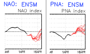
I guess folks need the modeled nice day(s) to time ... landing on an actual weekend day ... otherwise not worth mentioning. LOL. Yeah, can't say I blame anyone that hasn't 'cashed in' on the Pandemic WFH movements and was stuck still commuting to the inspired mise se science of florescent lighting, the murmur of a printer, and some distant barely audible conversation as the only aspects that break into silent rage of getting in a deliverable on time. For those of us that have been working at home ... it's going to be windows open and birds arguing over who gets the hen. Today, tomorrow and Friday ... at least west and N of I-95, these should all have window open afternoons. They are all top 20, maybe top 10 contender gems Fri/Sat. Saturday does look like MEX MOS is like dabatbase brain numbed and horrible. That sun and those synoptics on top of one another will generate some heat in the sheets for us. 76 F with light offshore wind, and even a DPs into the lower 50s too...etc. Next week toward mid month ? yikes - The GEF -based PNA has been flagged for 10 days with stalwart consistency to rise from -2 to +2 SD while the NAO nadirs ... that's a large telecon converged signal. Either one solo would lend ... but in tandem that starts stacking the odds. It's also a duet song and dance we never once observed spanning the last 4 months when in principle we really wanted to. It is what it is. I've been saying along that seasonal modulation/ .. damping is ongoing, and is an offset factor. It may keep whatever takes place on the palled side. However, we have celebrated(suffered) bigger winter events during April 15 to May 1 - duh.. It's not a matter of 'can.' It's a matter of diminishing return rate, but eventually they do occur. I've looked over some of the bigger April events in history. A common denominator/ .. behavior that took place in all: an inject of cold took place closer to the actual 'main' cyclogenesis while it was developing - I think crucial timing sort of 'synergistically' favored the colder results. You know? 'more than the sum of the cold parts' caused a result that over performs.. I suspect these yore and lore jobs got some of that advantage. ..interesting. But most important, that sort of delicate timing cannot really be resolve at D7-10 range ... About all we can do is rely upon the layout to detect whether probability is situated to do so - if past could ever serve as any sort of model. Having these in tandem as the ides of April are nearing, is just such a layout in my mind. If I had been monitoring this look back in March I would have a thread going for early risk assessment as it is.
-
Lol I know its like sign me up to be poked as many times possible for one vaccine yayyy
-
Can you choose the 1 or 2
-
Biden’s trying to mandate all states open to vaxing all ages by Apr 16?
-
keep in mind ... "suspect" is not a declaration or anything ...lol The context of that is more of suspicious of the Euro's scale and degree of toaster bathing - ... I will say, so long as the PNA is positive/rising, and the NAO stays negative, at any point a substantial impulse could avail of that and it all goes south really quite - I mean the scaffolding for it is in place. It's almost like we are dodging bullets and getting sort of lucky, relative to +1 PNA/ ... -2 west based NAO The Euro appears to send a BD down over the weekend too...it's just that it's merged into the on-going top-heavy pressure pattern ( higher pressure N of Maine already..) so it's a bit obscured in there. One would expect a BD might get sent down with that block getting stronger over NE Quebec. It's a lot of confluence and a BD should really evolve given time... I could see us being laze faire with near hammock glut afternoons and then... duh duh dunnnnn - time to slam some screen doors and snap flags to rudely re-introduce the planetary spring curse. Lol
-
Not to be a semantic noog but ... that 'switch,' in that context you use ...sort of implies the opposite of 'winter won't die' ?? I don't see this as diametrical to that - which would mean 70 to 80 and summery ... which we have had March's and April obscenely warm like that ... mainly sprinkled about the statistics since the year 2000. On that .. prior to 2000, I personally NEVER saw that happen. I have, since 2000, experienced three springs that held warm anomalies startlingly high at all times, and more than a handful that at least had an intra-seasonal run in with exotic heat for so early in the season. Not sure what's up with the climate that's not changing Being dyck there a little ... But you get my meaning - Anyway, this spring seems ... pretty darn average frankly. Oh, it'll be above average to some degree, ... perhaps atoning for the CC footprint. But not outlandish like those mentioned above ( save that one warm period a month ago maybe ... )... By and large, not terrible misery misted, and not eerily hot either. We still have April to go... and frankly May is not guarantee around our region of the world either. But just sayin' so far -
-
Little uneasy in saying this ... buuuut, the latter mid and extended range may get forced by the sun to be less miserable. This typically happens in spring. If a given scenario is coming along without necessarily strong enough anomalous forcing, the mid and extended dour looks will tend to end up not as bad once said range is in short. 2005 May? April 1987 ? ... those are examples where said forcing WAS substantively powerful enough to block the sun so to speak... And the S.A.D. putrescence was so dour as to challenge the very endurance of man for having achieved that, too - But that 00z Euro operational is coughing up hair balls in that look... Strikes me as more residual and I bet the model smooths some of that out as it near/future guidance. That weird neg tilted trough at D8.5-10 that only has 2 contours around it...probably doesn't really have enough actual mechanical energy to dictate the surface pressure pattern from Bermuda to Chicago when push comes to shove. This week did that ? You man recall ... 7 day ago, the Euro had us in a rhea wheel of real 38 F misty shits .. with light rain and wet snow ( non sticking variety ) for days... As this time arrived, gradually aspects designed less putrid. Now look what this turned into. The vortex become gradually less obtrusive and stalled, weaker really ... and tomorrow thru Friday could be 64 to 72 with high April sun by day, though an open emerald blue sky. You'll look down the street and see the air shimmering and with light wind. These could be candidate top 10 qualifier afternoons. Meanwhile the nights may even stay above freezing - kind of reminds me of those nape days last week, only 15 milder at night. Those were nuts! We had one day here ... 19.4 was the low at 6:35 a.m., and it was 64 average among the home-stations within a mile or two of town at 4 pm. Sun set, 41 immediately.. ... as an aside, we are limping into green up here in the interior ( at least in Nashoba 'nighttime cold hell' Valley). I 'm sure down along the S-SE Coastal Plains you're further along. Really the shrubbery buds are sluggishly opening, lawns and fields are sort of greener. However, I am noticing the 200 year old maple, corner to my property, it's buds are starting to swell just a little. I suspect all these various prominences will accelerate(d) their intentions of life by week's end. I have noticed over the years - really accelerating green-up is more about keeping the nights above freezing.
-
Oh... heh Pittsburg NH
-
Heh...makes me nervous that there are observations in various dimensions of the physical geography, at global and local scales, that were not supposed to be "real"ized until much later - as in 2070 ...etc. I don't recall what climate papers/ .. models, and/or consortium of scientist out among the greater ambit for which to cite for the general users of this social-media ...no, but, recall reading that turn of phrase in numerous areas from Coral Bleaching, to ice loss ...and various other observational metrics in between. So, tfwiw I suppose... but when you/we say "unrealistic," ( and I agree in principle that higher end cataclysms may be as unlikely as the lower end, just the same... ) ..the problem is in the middle sufffix: "real" Since there are physical observations that are beating the climate models to the punch ( so to speak ..), I am losing confidence in our notions/judgements of what is and is not realistic vs merely plausible.
