

Typhoon Tip
-
Posts
44,568 -
Joined
-
Last visited
Content Type
Profiles
Blogs
Forums
American Weather
Media Demo
Store
Gallery
Everything posted by Typhoon Tip
-
I used to make fun of you for this .. .but then it become too easy when considering ( specifically ) that choice of word syntax - lol..
-
I have a 250 year old Maple kitty corner my property that looms authoritatively over all others. Oh they try to compare and act like they're celebrities too, but they are just part of its entourage. Over the years I've lived in this house much longer than I ever wanted to ... I have used "General Sherman" as my pet name for its majestic scaffolding so vast as to provide it's own ecological kingdom ... Probably the perfect setting for a children's book, with a squirrel family, and "Mr tuck" the wood pecker..., and scary part of town where the honey bees are too temping to keep teenagers off of sweet drugs...be leery of society pitfalls and getting 'stung' heh I don't really think the 'blooming' part of spring is happening until that guy says, and he does so by the crack of the bud. They are not cracked, but they are huge! I don't see it holding back over today and tomorrow.
-
Today is intensely beautiful to the point of NWS creating a new category, and warning civility with it ... not to operate heavy machinery while under the influence of the ambience. It's like either this weather, or it's metaphor: girl/guy of one's dream, blanket, field of aromatic flowers, wine, cheese and bj's ... It's hard to believe that thickness as are really still 538 to 545 dm out there. With pop-corn cu and intense irradiance-scorching nape sun spot lighting in splashes as it cleaves in between them upon my lonely stage. It seems like it should be 552 DM with leaf bloom out there. Lawns green and growing, tho. I think there must be some convection already possible. With the sun continuing to add thermal energy to the bottom of a thickness column that resides under lower heights like this - that's sort of an indirect way of flagging instibility in the column. Low DP thermal instability ... light shower, single pop of thunder and modest toned-down microburst tendency
-
... But, perhaps that's about the change. A couple months ago I speculated on a warmer than normal spring. At the time I stated three plausible factors/or questions contributing: -- La Nina climatology -- HC expansion hypothesis ( could go either way ...) -- Whether or not these two factors would constructively or destructively interfere. In purer La Nina: ... you know, when I go back and just look at the coarse .. yet real monthly ENSO means going back to 1950s, https://origin.cpc.ncep.noaa.gov/products/analysis_monitoring/ensostuff/ONI_v5.php, and noting/comparing them to very warm spring/spring synoptic warm events over eastern N/A ... -ENSO appear to correlate there just based on a cursory scan of the data. -.5 to -2.0 ENSO in the 3.4 .. and adjoining basin notwithstanding, but some notables1976 April... 2012 April ...just to name a couple. 1976 was insane! The UML station at me alma mater put up a five day heat wave of 90 to 96 ... and looking through the data at the location, it wasn't a fluke episode as an island to the season. They were 70s if not 80s carrying on and on, and just seem to sort of seamlessly fade into mid summer that year. This year was similar in the ENSO spectrum... yet it doesn't seem sensibly to be doing the same sort of thing. Obviously it has not been 90 - ha. I think this is an HC spring again ... much like the dominant signal over the past 7 years... with disruptive early warmth fleeting 'momentary synoptics' not sustained, then failing to episodic or prolonged -NAO / .. blocking periods that regressed April and May at times. It would appear diurnal minimums skew the temps higher, and confuse/obfuscate the truth of what's going on. HC doesn't mean warm heights per se... the energy, in winter, is mechanical as fast flow; then when that seasonally terminates, the atmosphere responds during that d(gradient) period time ...with blocking... 'continental folding -over' causing super-synoptic 'tucking' over east N/A mid latitudes.. You have to almost understand non-linear wave mechanics as an emergent tendency more so than an actual visible weather chart footprint. Tendencies are why we get NE flow down the coastal plain from Maine - that's an example of in situ tendencies that 'favor' an outcome, and given any excuse to realize... the tendency dominates. I think when the Pacific is averaging a faster flow and then it tries to abate ... as it passes through some velocity/mass-balancing phase ...we pass through tendency for trough evolution over Ontario-Quebec and tucking E flow into the M/A... Think of it as an invisible Kelvin Hemholtz wave where the atmosphere is trying to get to that structure - Intensely hypothetic and speculative but I think it's an intriguing idea... "Hadley Cell expansion and plausible effects on hemispheric basal mode circulation during transition season" - that's the title of your paper. That all said... I surmise "IF" there is value to that - as in real .. heh - I think it is "partially" masking the ENSO spring climo. The 00z GFS offers 70s and 80s D8 to 11 .. 12 as obviously highly negotiable ... The 06z was even more impressive, with 90 suggested D10.5! ... The GEFs -based telecon spread neutralizes the NAO ( as has been the case for days in the nightly computations) ...while the PNA at least transiently demos a concerted dip to -2 ST out there D 7 -14. Meanwhile, the EPS spatial/synoptic mean is more like the GEFs in that regard, signaling that the operational Euro may be over-zealous with its conserving and/or introducing additional curved trajectories to the look from D7 to 12. I suspect that D10 meandering low is not going to be there - despite the 1980s in older poster's thoughts and nostalgia for New England springs... it's not the quite there because of the latter, but by convention of the Euro tending to slow and anchor flows an operational bias. I think all these deterministic methods suggest a significant warm up is out there to end the month.
-
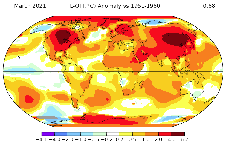
Yeah we didn't do terribly yesterday and you ... well, ' I ' .. .could really tell the diurnal 'stretching effect' is now here. It's not a real thing, but it's something I notice. When the days lengthen temperature may plateau ~ 12 to 2pm in atmospheres that are really cool profiled and not very supportive of mild ... just by thermal soundings at dawn alone on those days. But we have the sun! It's almost like it wants to do the winter high timing, where the high is 11:45 am ...and then the afternoon holds or falls but seldom rises without some other synoptic means. Between now and perhaps the first couple of weeks of September the sun is holding it up. The temp is trying to ruin summer and depress people ( haha) but is in a tug-o-war in that plateauing thing. But insolation finally wins and lags the temp up for another 3 or 4 somewhere 3:30 to 5 pm. Gives the allusion of protracting the afternoon that way. Perhaps more an affect, rather than an effect of longer daylight but .. concomitantly, longer light still means more heating -so ... On November 21st, without synoptic intervention or some other offset, the sun alone is done by 11:40 am... but it's closer to 5:30 pm in May 21... somethin' like that. And word on the above normal - man.. I posted in consternation over that subject matter just yesterday, providing NASA's March global temperature anomaly publication/annotation to help elucidate the weird disconnect that is occurring between the actual experience of March and April so far, compared to what is being empirically measured in the temperatures? It's amazing really ... April is flaring in with +2 to + 3 at all four climo sites around SNE for April, while all I can remember for some reason is being annoyed by cool wind on the nape and having to ( grudgingly enjoy) live through a 1:7 year type April snow event. It's like an inferno spring without feeling any warmth. interesting
-
Lol, right on schedule - still waiting on the La Niña spring
-
Looking over the various ens means and oper. tenors /.. telecons, Thurs trough may be the last body blow ... things seem to favor more benign troughs, N stream contraction polarward leading to more seasonal oscillations after.
-
It almost seems immoral to add that excessive single point winter skewing piece of like metaphysical lie to till
-
It’ll devolve from primary media to a cottage industry ... but it won’t go away entirely for reasons cited here - if the proportions are similar there’ll be millions that’ll provide enough for ‘boutique’ ... eventually There are other formats to consider like dinner theaters like Chunkies and so forth - those kinds of places… People have to get their kids outta their houses one way or the other ... the list goes on ...there’s gonna be lots of reasons why people want these kinds of outlets so there will always be at least some demand enough to keep a few options accessible. ... but the age of theaters providing the only means for the silver screen experience are over.
-
This is really bizarre ... ...It's hard to know where perception/acclimation and acceptance fails, and truth and reality take over. Having suffered March - really does not seem to support this, but - it's real... And the unique method of belying continues to deceive ... because the first 15 days of April are ~ +2 to 3 (ave) between the 4 majors in SNE, above normal... with a [ perhaps ] 1:6 or 7 year return rate snow event tucked in there. - I dunno. I just don't recall March 'feeling' sensibly anywhere close to that orb fire ball over N/A like that. I mean ...these are in whole degrees C
-
Nope ... ... this region of the planet shall remain the only cold hole relative to the CC footprint/ .. global warming for EVER ever ever
-
I think the story about Texas new case count plummeting to COVID-19 relative era record lows after they've relaxed their mask and distancing/ sheltering aspects is intriguing. It seems there are other claims surfacing ... all of which are beginning to evince that many measures being 'mandated' if not imposed by force of anathema/'shade' if one doesn't, were not well- foundationed if perhaps ever necessary. I remember wondering months ago ... it seems almost paradoxical: how is encouraging family's to hunker down and swap air in median household tech ventilation, in and around typical rural pathogenicity ... consistent with spreading out and social distancing? that seems to be a contradiction in terms.. Meanwhile, we have seen case spikes at holidays and week's aft as though doing that 'helped' the spread, not hindered it as intended - or thought and imposed... etc. I mean I think I get it - ...if it sweeps through household than maybe 5 to 6 people get it, then it stops there...but if those infected were spreading it outside the home... that means 50 to 60,000 in viral propagation/dispersion modeling and all that.. . I guess, but Texas seems to dispel that very convincing logic - suggesting it's not true some how for some way. Then, recently CDC/ .. science states that it is actually hard to catch C-19 off a door knob and so forth. .. People were Lysol spraying their produce ... probably at expense of their own sperm count doing that - lol.. heh. These contact surface transmissions are extremely poor and inefficient, and one individual has like a 1::10,000 chance of getting a dose sufficient enough to make them ill.. It seems there are a lot of aspect about this that 'novel' - as in new and unknown ... - were guess work? I can't say I blame - until we know ...we don't. But I just find it all intriguing. And of course hindsight is 20/20
-
You know ...a-heh, I came in here to plunk in an entirely different observation, but your write up is too 'softly' disturbing, as much as it is captivating - namely because it hearkens to a recent study I was reading over in the Earth link of Phys.org's encyclopedia of various paraphrased scientific papers. It was regarding a slow moving apocalypse ( maybe ...), one that no agency or individuals of ubiquity really are even aware - not popularized yet by big media's telling us what we should care about ... give it time. But apparently ... males of Industrial extraction, globally .. regardless of racial or ethnic distinction, have shrinking testicles, penises, and sperm counts. Yup ... But their lawns or Ireland dreams - ha ha, call it the Ireland Revenge for the Irish Curse - The study ( and there are more...) focus on ambient/environment pollution from anthropomorphic, western civility activity spanning generations ...and apparently as you are intimating, having a cumulative non-degenerative presents in the background biota is now impacting on male reproductive health - it's probably not just humans, common sense and biological awareness notwithstanding... just find your comments interesting ( bold above ..); although it may not ( or may ..) be involved/linkable to this other arena of science, it all still eerily hearkens to the ills and poor forsights of human ingenuity spanning the past century's hockey-stick leaps of "advancement" - it's like we've advanced our own demise, while we continue to assume and conceit in our "conquering" nature's domain - fascinating. Don't tell the hipsters that "Gaia" isn't onto us - we have a population over -abundance of abusing mouths and Industrial farters ... so, cut their nuts ... population corrects. Piece of cake - But enough with the gaslighting sermon - So the snow that fell for this recent event is all but completely vanquished already from the lawns and fields around town here in Ayer, but all these area expanses .. it seems as the snow receded it exposed a flashing over to this amazing emerald green - really pops! There's something about that snow that was the "real" fertilizer - ironically... - just like a magic potion. It's really amazing that noticeable difference. I've heard of the expression, "Farmer's Gold" growing up in the Midwest ... pertaining to snow events in April but wow -
-
Exactly ... sort of reminiscent of that October deal last year - tho I am not saying it's a redux or an analog or anything.. . The key is synoptic overturning mid deck to surface behind that lifting wedge - and if there's some evap neggie CAPE, that'll certainly help that set up too - But the timing .. yeah good point. I didn't look too closely precisely on frontal timing so -
-
Ends Severe ? ... early prelim looks like a wind risk with huge diabetic destabilization and intruding mid level jet toting hgt falls
-
It’s like there’s a histrionic pandemic more than anything
-
RE UFOs All the Pentagon is saying is the video isn’t faked It seems there’s a tendency to think that means there are extra terrestrial objects flying around in the sky but all they’re really saying is yes ... it’s legit as a video and it is unidentified what is being filmed after the fact - nothing else.
-
I realize few like to engage in this subject matter - as it typically goes largely ignored ... but, this actually adds empirical evidence to my spring winter lagged 'continental folding' pattern hypothesis. It basically is that Pac velocity surplus entering western N/A as the continental gradient from 70 N to 35 N begins to seasonally break down, that's triggering a hemispheric scale quasi Kelvin-Hemholtz wave effect that arcs/tends to B.C.... then tucks at super synoptic scales E of mid latitude points and drills SE Canadian thicknesses down ... But it's transient. By later on in May and June - it actually helps explain why these NW NE heat waves have been happening... The folding ridge arc settles S as the Pac gradient lessens ...The conveyor aligns over those regions and draws early SW eml air over that region ...while we see a weird tendency to counter balance that flow with a quasi polarward displaced E trade coming into the MA ... DCA is concomitantly colder that BTV pretty frequently in recent years too just by anecdotal memory but don't hold me to that.. Anyway, our location/SE Canada, in geographic space in relationship to the hemisphere/plantery spatial dimension, favors us cold because we are in the cross hairs... might also help explain why since 2000 ...NOAA's state of the climate monthly publications indicate that ~ 2/3rds of the months in the data represent a relative cool anomaly in or at least near the eastern N/A circumvallate. Perhaps in short ... as the advisers of climate change have noted in modeling all along, CC and warming atmosphere has offsetting cold holes that tend to counter intuitively go against the integral - we may just be one of those regions.
-
Lol... ho man... I was just reviewing the 500 mb run up to that d10 Euro ... that thing's trying to put a single season snow total down in one event. ...at the end of April no less... The hilarity would know no bounds if that was like a 1::784 year deal ( so basically it's never happen since white man stole the continent ) that dropped 70 inches...bringing the seasonal snow total to the snowiest year ever in history ...specifically to this particular winter's complete shit show ? man...
-
Not that anyone is in a present frame of mind to take this in at this point but ... the GEF telecon is warm - not the Euro look. ... End winter and escape to summer enthusiast have at least that going for them -
-
They've been radically more frequent since 2000 ...
-
you know what ...I think yeah - it was within two days of one month from the solstice ... not sure which direction.
-
Really should be the last one ... LOL There's been appreciable snow events into May ... and the definition of "appreciable" changes relative to absurdity. Like, ...I recall peering down from my 3rd floor window down upon Chestnut Street ... living in Waltham back in 2002, during wind swept mix of large cat paw rain drops and the occasional mangled bow-tie noodle sheeting down the street. May 20 2nd One month before the Solstice? Yeah ...that certainly qualifies as appreciable by shear insult ... That's the latest relative to calendar while at less than 1,000' elevation, along the 40 to 45 N latitudes that I recall sniffing snow. That event actually was putting down 2-3" in some of the Worcester Hills if memory serves - surprised that isn't talked about as much. Anyway, the notion cannot be completely withstood with that sort of thing, but we ARE definitely also on the curve of lessening returns. Plus, this always seems to happen and it's annoying ...albeit a petty observation of me ( shame...). But we're bathed in misery mist and snow for lucky folks at an obnoxiously late date, and the Euro ALWAYS does this - picks that psycho-babble moment when all these user strings are pulled by the present cold system like so it's 'totally possible,' to put out an unlikely look that way - just so we can play the 'pretend we're not hoping game' delusion. I really am not though. Man...
-
Wee ... the U.S. is lit up like a "death"mas tree ! ... not sure how anyone can be proud to be an American - or be dubbed sane if/when hiding from that truth behind politically obscuring dogma - evasive. End life, is not a state of mind. "Merry deathmas ... too youuuuuuuu"
-
yeah... as Scott mentioned a while ago, the 'inundation' phase may be past by the storm's life cycle,... now separating into a banded affair more so on rad and when it's mid April ...those attenuation regions may not do well - we aren't here. ..heh. When we maxed this beyotch ...circa 10 am, we were borderline S+ for a stint, and the temp made its way down to 32.X ... but since, we keep lulling on rad and ground truth has been light snow tending to fall more and more like white rain, and the temp has bulged to 35 ... So, if you're lucky enough to be in a band, cheers, but this isn't being fairly distributed as spring cruelty seldom ever is anyway - LOL


