Typhoon Tip
-
Posts
44,568 -
Joined
-
Last visited
Content Type
Profiles
Blogs
Forums
American Weather
Media Demo
Store
Gallery
Everything posted by Typhoon Tip
-
I write science fiction and have been published and I can tell you ... it is actually difficult to premise a sci-fi tech that out gawks the actual shit we are seeing these days - so... that 'fail' is not hard to do. ahahaha But yeah... how about, "Cryopocalypse" lol But I like 'sanitizing theater' .... Phin and I were musing a couple weeks ago about this "virtue signaling" shit ... You know, pulling up a mask when someone eye-balls you from the other side of the gym or hall as you pass by. It's a sub-class of the same affectation people feel they now have to do to deflect nosy self-appointed cleanliness nuns. I bet their kids never masturbate and grow up sociopaths, too.. OH yeah ...a great deal of hygienic awareness and sanitation is necessary - I'm not saying people should eat an Italian sub with black cake under their fingernails or anything ... but the 'obsessive compulsive' nature of it is a distinction that ... actually science is beginning to materialize, may cause more harm then good.
-
Personal conjecture .. so tfwiw: A slow death ... in fact, it may not entirely go away. There is likely ( imho) to be residual, elevated readiness that to some appears to teeter with compulsion ... - it won't be a perspective and practice shared by everyone or their affiliations, evenly, either. So there's that joyous vitriol to look forward to. So it's a bit of hypothesis but there seems to be a smoldering aspect of "social distrust" about this whole thing, as well. Most that possess a modicum of realism are well passed the lunacy of whether this thing was real or not. But ... they don't trust the media, and by media that includes all. The "Industrial Media Complex" ( I euphemistically refer..), to social medias like, well, this one and et al... Nor do they really trust the urban rumor mills, either. How can we? That probably doesn't lend to believing the risk is ultimately ever going to return to any pre- C-19' perception and practice, no. That's one factor among many... The other aspect is being warned by environmental science that we are probably passing over a threshold. Over-population, festering amid Climate-Change-forced biota drift/ species migration... These combine for loading unfamiliar infectious agencies at a faster adaptation rate than the new environment is capable of responding. And that 'out-pacing' is the whole loss of that battle. Those lend to new pathogenic scares, in the least ... if not unleashing new pathogenicity. And frankly.. that's not scare tactics - that's real. So some readiness and preparedness has to be remain in vigil - That probably doesn't mean we need to be fastidiously running around after everyone and lowering fertility with weird chemicals and causing tumors as germaphobic dim wits, no. That level of extremeness may ease off - ...in fact, much of that may never have been necessary ...
-
It's one of those days where every time you look at this image above... say once per half hour ... it looks discernibly better ( as in clearer ), yet, the sky over you never seems to change and the sun has no direct shadows. ...it's like deliberately waiting to the last possible gasp of cloud to make sure it's maximized the depth of butt banging the afternoon - lol
-
In southern New England ?
-
-
Even down in north -central PA it's doing this... You can see a stationary cloud production axis and the resulting saturated ceiling layer is a shit streak blotting out the sky over NYC some 150 miles away
-
It's comical ... we get a bust to keep it cold today ... and tomorrow, the NAM will be right! thus... we always "GET" to be cold - yay! just what we wanted - lol
-
Lol... I almost want to split my residency between ... any-f'um-where-else but here from mid April until late October, then return for winter. I bet if you took our specific location and compared it to every other point around the hemisphere at this latitude, we would find that this shit only happens here
-
If that convection doesn't form like the NAM has for overnight ... as I annotated above ... it may bust the other direction tomorrow - long shot.
-
Looping the hi res vis ...the cloud production is clearly elevation caused - these have an obvious orographic forcing aspect to them. It seems perhaps the low level resolution/ topographical featuring is the reason for the error/bust by models ... we have a WNW flow bumping over the elevations blah blah. Even the NAM's meshing missed this effect: https://weather.cod.edu/satrad/?parms=subregional-New_England-02-24-1-100-1&checked=map&colorbar=undefined
-
If you're interested... It's because the dew points are still relatively low ... much lower than the ambient air temperature when the rain starts. As the rain falls into a dry air mass, the evaporation off the particles cools them down to freezing ( wet bulb temperature ..) prior to completely evaporating, so you're left with a sleet particle despite the temperature being relatively warm. It's a phenomenon ... not hugely uncommon in spring... I've seen rain with bouncing sleet pellets while as mile as 52 F temperature ... if it persists... the air temp will saturate down to say 37 and just be light rain - losing the evaporative cooling the cooler temperature, counter-intuitively no longer creates the ice.
-

-
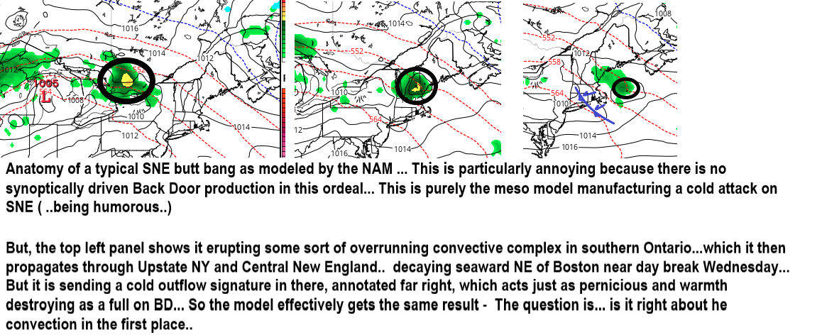
Heh 00z NAM back S and cold Wednesday
-
Super moon is sick tonight. 7% bigger than normal seems like a small number but when you’re talking about a celestial object that has a way being a rather imposing result. I mean it’s like right there.
-
I seldom trust any icon of our celebrity fabrication driven culture. The real heroes are always drubbed up out of the silent sectors of sacrifice ... and the interviewee couldn’t care less whether they’ve caught a moment of charisma. They have work to do Betterment of humanity and the better part of valor have nothing to do with magazine covers and 60 Minute’s biopics. Having said that ... whether Elon is somehow masterfully conning the entire world or not remains to be “Socratically reviewed” ... but his company is physically placing humans in orbit ... etc He is in the least proven by air apparent to be a curator of talent and tech for those achievements
-
Cursory surmise on that ... it’s a disadvantage when needing to move quickly when the whole social structure has to move in an en masse... i.e bureaucratic limitation is obviously going to be speed. Contrasting ...free markets with a common vision ending up at a non-competitive goal ( or ~ less competitive )... rare as that may be, will be faster for being unencumbered during the entire life cycle of product evolution to delivery.
-
Wed may yet be warm S of ~ KMHT
-
Internet did that ...
-
18z American guidance attempted to edge N with the wavy front Wed ... Friday. NAM now ops to drop it down Friday and drill a humid rainy messy low circulation straight through, ... but the GFS takes Friday's low up the St L. Seaway and really sends us soaring first dp mid or upper 60s under 80s style warm sector. Then next week, the GFS goes flat ..all fields and really whisks the front/ .. air mass rapidly out and replaces with above normal heights/ flat ridging by D8-10 ... 582 dm IND-LGA ... Typical at that range, it has trouble loading warm thickness into the higher heights so suspect that 558 dm ends up 564 D7 ish... Different look overall then the Euro's cold 850 mb insert -
-
Too bad we don't have an evac mechanism aloft because that 0-3 ... perhaps 6km on Wednesday looks pretty positive in the direction shear... Noting Logan with 160 to 180 Deg and an LI -1 with -4 over LGA at 24 C in the T1 down that way, and ALB now popped to 20 on this 18z NAM ...so the w-boundary is fiddling in the run and could end up a slightly N... SRH ...
-
Funny ...I couldn't find hand sanitizers after the run on the markets last spring... SO, I went on line - I found this organic hyper concentrated shit that's fragrance free and got all tough and manly and had 6, 12 oz containers of it delivered. I still have 5, 12 oz containers unopened and the one lingering, 10 oz full container ... having never contracted Covid-19 in the 18 months of this vacation from pragmatism. Stuff smells like a industrial "tumorigenic" solvent used by hazmat encased cleaners of O-rings from the Space Shuttle rocket testing days... holy hell is that shit bad. And supposedly this is organic, in big gaudy it's safe letters because of the word organic. like... I thought carbon present in molecules determines organic and I started wondering ... - ...snake venom is organic .. Mayo, nuero, cyto and necro toxins... . So is the dreaded tetra-dutoxin from Box Jellyfish for f'-sake. I wasn't thinking things through, and as much as I have fun chastising and impugning, I too was pretty heavily swept away in the early histrionics I guess.
-
Man, that was 10 years... blink -
-
I've turned the phrasing recently ... ... the moment in time the "Industrial Media Complex" figured out a way to turn thumb swipes, mouse clicks, and television channel pings into money ... we were doomed - .. it's one big festering din of bate-and-switch enquivocation and lies, and the profit only happens once the headline is crossed ... The whole system needs a Carrington Event The funny thing about that is that it would almost be okay ... if the mass ballast of population learned the 'cry wolf' lessen and yeah yeah yeah'ed it. But this modern era is exposing that trophy culture is the biggest lie of all, because the majority is too stupid not to fall for headlines.
-
Mm hm ... it says that 10 minutes after filming this ... internet pornography arrived -
-
I'd be happy if it we got some sun and crispies... CB's are fun stuff when bubbling around. One thing that is different about this warm frontal/stationary stall them days is that we don't see a very convincing +PP N of the boundary? If we did ...we could go ahead and assume NE/E shit spritz, but the low levels may not be transporting that way.